Discover extraordinary places shared by our community of travelers
Córdoba
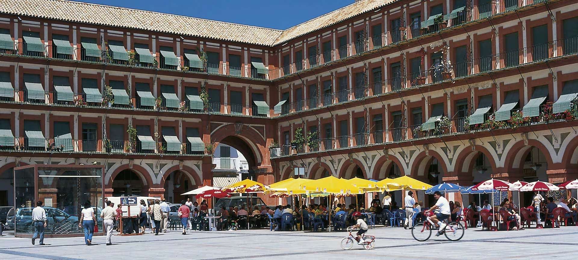
## Description Plaza de la Corredera is one of Córdoba’s most iconic and historically rich public squares, offering a unique blend of architectural charm, cultural legacy, and vibrant local life. Unlike other Andalusian plazas, Corredera stands out as the only rectangular main square in the region built in the Castilian style, reminiscent of Madrid’s Plaza Mayor. Its symmetry, arcaded buildings, and colorful facades make it a picturesque and inviting space for both locals and tourists. Constructed between 1683 and 1687 by architect Antonio Ramós Valdés, the plaza was commissioned by the city’s corregidor, Francisco Ronquillo Briceño. Over the centuries, it has served many purposes—from bullfighting arena and public market to a site for autos-da-fé and even executions during the Spanish Inquisition. Today, it’s a lively hub filled with cafés, restaurants, and artisan shops, where visitors can enjoy a coffee while soaking in the atmosphere. A little-known fact: during renovations in the 20th century, Roman mosaics were discovered beneath the plaza. These are now housed in the Alcázar de los Reyes Cristianos, offering a glimpse into Córdoba’s ancient past. Another curiosity is that two buildings in the square—the Mercado de Sánchez Peña and the Casas de Doña Ana Jacinto—predate the plaza itself and break its otherwise uniform architectural style. ## Location Plaza de la Corredera is located in **Spain**, in the **Andalusia region**, within the **city of Córdoba**. It sits in the historic Axerquía neighborhood, just a short walk northeast of the Mezquita-Catedral and the Roman Temple ruins. ### How to Get There - **By Foot**: If you're exploring Córdoba’s historic center, the plaza is easily reachable on foot from major landmarks like the Mezquita or the Jewish Quarter. - **By Bus**: Several city buses stop nearby, including lines 3 and 7. The closest stop is “San Andrés.” - **By Taxi**: Taxis can drop you off directly at one of the plaza’s entrances. - **By Car**: Parking in the historic center is limited. It’s best to park in a nearby garage and walk. Its central location makes it a perfect spot to pause and enjoy the city’s rhythm. ## Tips - **Visit in the Morning or Late Afternoon**: These times offer the best light for photography and a more relaxed atmosphere. - **Try Local Tapas**: The plaza is lined with bars and restaurants serving traditional Andalusian dishes—salmorejo, flamenquín, and local wines are must-tries. - **Look for the Mosaic Plaque**: A small plaque commemorates the Roman mosaics found beneath the square. - **Explore Nearby Attractions**: Combine your visit with stops at the Julio Romero de Torres Museum or the nearby Roman Temple. - **Attend a Local Event**: The plaza occasionally hosts concerts, markets, and festivals—check local listings for current events. - **Respect the Space**: While lively, the plaza is also a residential area. Be mindful of noise and local customs. ## Conclusion Plaza de la Corredera is a vibrant and historically layered square that captures the essence of Córdoba’s cultural and architectural heritage. Whether you're sipping coffee under its arcades or exploring its storied past, it offers a memorable and authentic experience in the heart of Andalusia. ## FAQ **1. Is Plaza de la Corredera free to visit?** Yes, the plaza is a public space and open to all visitors at no cost. **2. What is the best time to visit the plaza?** Spring and autumn offer pleasant weather and fewer crowds. Early morning and late afternoon are ideal for photography. **3. Are there guided tours available?** Yes, many walking tours of Córdoba include the plaza as a stop, often with historical commentary. **4. Is the plaza wheelchair accessible?** Yes, the square is flat and accessible, though some surrounding streets may have cobblestones. **5. Can I eat at the plaza?** Absolutely. There are numerous cafés and restaurants with outdoor seating. **6. Is it safe to visit at night?** Yes, the plaza is generally safe and well-lit, though it’s always wise to stay aware of your surroundings. ## Links - [Plaza de la Corredera – Spain.info Overview](https://www.spain.info/en/places-of-interest/plaza-corredera/) - [Plaza de la Corredera – Wikipedia Entry](https://es.wikipedia.org/wiki/Plaza_de_la_Corredera)
GemVoyage Team • World
Kutaisi
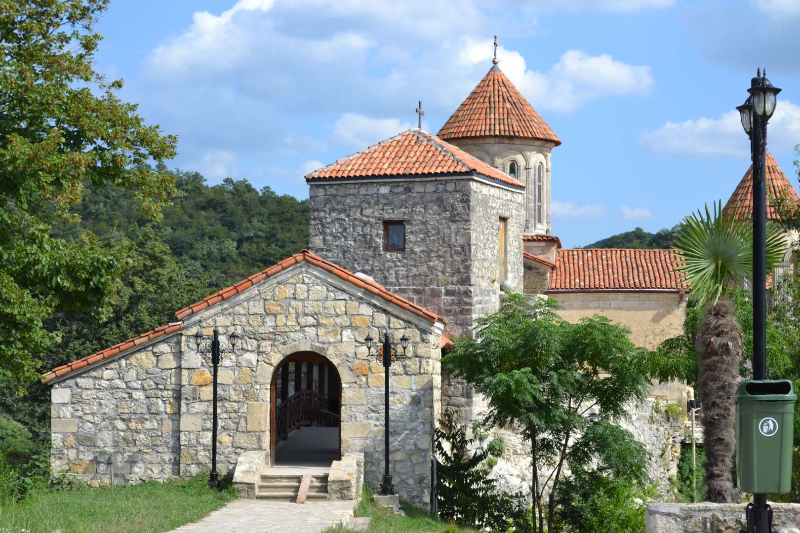
## Description Motsameta Monastery is a hidden gem nestled in the hills of western Georgia, just outside the city of Kutaisi. This 8th-century Georgian Orthodox monastery is revered not only for its spiritual significance but also for its breathtaking location—perched on a cliff above the winding Tskaltsitela River, whose name translates to “Red Water.” The river earned this name from a legend tied to the monastery’s origins: two noble brothers, David and Constantine Mkheidze, were martyred during an Arab invasion, and their blood is said to have turned the river red. The monastery, whose name means “Place of the Martyrs,” was built to honor these brothers, and their relics are preserved in the crypt beneath the church. According to local lore, crawling under the crypt and making a wish may lead to it coming true—a tradition that continues to draw pilgrims and curious visitors alike. What makes Motsameta truly unique is its intimate scale and serene atmosphere. Unlike the more famous Gelati Monastery nearby, Motsameta feels like a quiet retreat, surrounded by dense Colchic forest and echoing with the sounds of nature. The monastery’s architecture is classic Georgian, with arched windows, stone walls, and a red-tiled roof that glows warmly in the sunlight. A little-known fact: there’s a legend of a secret tunnel connecting Motsameta to Gelati Monastery, used during times of war to protect monks and relics. Though the tunnel remains a mystery, it adds to the allure and mystique of the site. ## Location Motsameta Monastery is located in **Georgia**, in the **Imereti Region**, near the city of **Kutaisi**. It’s situated about 6 kilometers northeast of the city center, making it easily accessible for a half-day trip. ### How to Get There: - **By Car**: From Kutaisi, it’s a 15-minute drive through scenic countryside. Taxis and rental cars are readily available. - **By Foot**: Adventurous travelers can hike from Gelati Monastery to Motsameta through forest trails, enjoying panoramic views along the way. - **By Tour**: Many local tour operators offer combined visits to Motsameta and Gelati, often including historical commentary and transportation. The road to the monastery winds through forested hills, offering glimpses of the river and valley below—a journey as rewarding as the destination. ## Tips for Visitors To make the most of your visit to Motsameta Monastery, consider these helpful tips: - **Visit in the Morning or Late Afternoon**: These times offer the best lighting for photography and a more peaceful atmosphere. - **Wear Comfortable Shoes**: The path to the monastery includes uneven terrain and steps, so sturdy footwear is recommended. - **Respect Local Customs**: Modest dress is appreciated, especially when entering the church. Women may be asked to cover their heads. - **Bring a Camera**: The views from the cliff and the monastery’s architecture are incredibly photogenic. - **Combine with Gelati Monastery**: Visiting both sites offers a fuller picture of Georgia’s medieval religious heritage. - **Make a Wish**: Don’t miss the chance to crawl under the crypt and take part in the local tradition. ## Conclusion Motsameta Monastery is a tranquil and spiritually rich destination that blends history, legend, and natural beauty. Whether you're drawn by its sacred relics, its dramatic setting, or its quiet charm, this monastery offers a deeply rewarding experience just outside Kutaisi. ## FAQ **1. Is there an entrance fee to visit Motsameta Monastery?** No, entry is free for all visitors. **2. How long does it take to visit the monastery?** A typical visit lasts 1–2 hours, including time to explore the grounds and enjoy the views. **3. Can I visit Motsameta and Gelati Monasteries in one day?** Yes, they are close to each other and often visited together. **4. Is the monastery accessible year-round?** Yes, though the forest trail may be slippery in winter or after rain. **5. Are guided tours available?** Yes, local guides and tour companies offer historical tours that include Motsameta. **6. Is the monastery suitable for children?** Yes, but supervision is recommended due to the cliffside location and uneven paths. ## Links - [Motsameta Monastery – Georgia Travel Guide](https://georgia.travel/motsameta-monastery) - [Motsameta Monastery – Wikipedia Overview](https://en.wikipedia.org/wiki/Motsameta_monastery) - [Motsameta Monastery – Imereti Tourism Info](https://georgia.to/en/places-to-go/imereti/motsameta-monastery/)
GemVoyage Team • World
Cairo
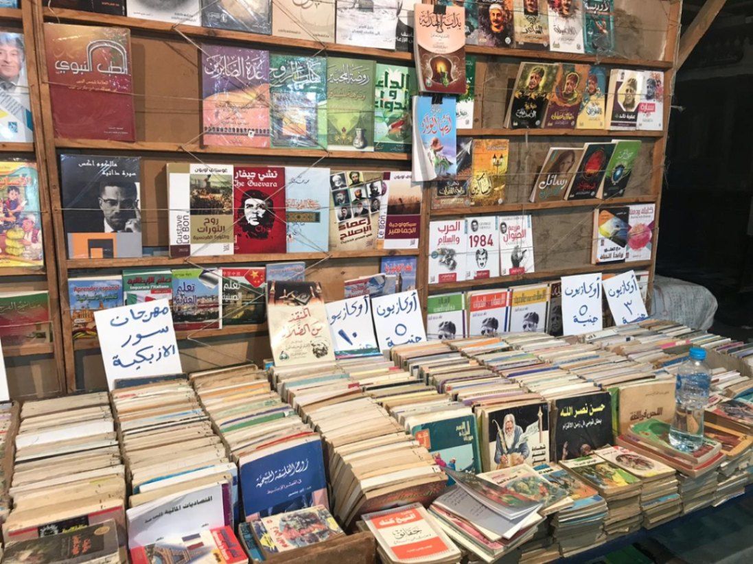
## Description Al-Azbakiyya Wall Book Market, known in Arabic as سور الأزبكية, is one of Cairo’s most distinctive and culturally rich attractions. Located near the historic Azbakeya Gardens, this open-air book market has long been a gathering place for readers, students, and collectors in search of affordable books and rare printed materials. The market is famous for its rows of simple stalls and tables stacked high with books covering every imaginable subject, from classical Arabic literature and religious texts to modern novels, academic works, and children’s books. What makes Al-Azbakiyya Wall Book Market unique is its role in preserving and circulating literary heritage at accessible prices. Many of the books sold here are second-hand, out-of-print, or rescued from private libraries, making the market a haven for hidden literary gems. A lesser-known fact is that some vendors specialize in vintage magazines, old school textbooks, and early 20th-century publications that are difficult to find elsewhere. Another interesting detail is that the market becomes especially lively during the annual Cairo International Book Fair, when sellers temporarily relocate to fairgrounds while maintaining the spirit of the original market. Beyond commerce, Sur Al-Azbakiyya represents Cairo’s deep-rooted intellectual culture, offering visitors a chance to engage with the city’s literary soul in an informal and welcoming setting. ## Location Al-Azbakiyya Wall Book Market is located in **Egypt**, in the **Cairo Governorate**, within **central Cairo**. It is situated near **Ataba Square**, close to the Azbakeya Gardens and within walking distance of several historic and commercial areas. The market is easily accessible by public transportation. The **Ataba Metro Station** serves Lines 2 and 3 and is the most convenient way to reach the area. Numerous buses and minibuses also stop nearby. Due to heavy traffic and limited parking, public transport or walking from nearby districts is strongly recommended. ## Tips * Visit in the morning to browse comfortably before the area becomes crowded. * Take your time and explore multiple stalls, as prices and selections can vary widely. * Bargaining is common and generally expected, but should be done politely. * Bring cash in small denominations, as most vendors do not accept electronic payments. * If you are looking for rare or academic books, ask vendors directly—they often keep special items tucked away. * Be mindful of your belongings, as the area can be busy. ## Conclusion Al-Azbakiyya Wall Book Market is a living cultural institution that reflects Cairo’s love for knowledge, literature, and learning. Whether you are searching for rare books or simply soaking in the atmosphere, it offers a unique and deeply local experience in the heart of the city. ## FAQ **What kind of books can I find at Al-Azbakiyya Wall Book Market?** You can find a wide range of books, including Arabic literature, religious texts, textbooks, novels, magazines, and children’s books. **Are the books new or used?** Most books are second-hand or older editions, though some new and reprinted titles may also be available. **Is the market open every day?** The market is generally open daily, though hours may vary and some stalls close on Fridays. **Can tourists who do not speak Arabic visit?** Yes, visitors are welcome, though knowledge of Arabic helps when browsing and negotiating. **Is photography allowed?** Photography is usually allowed, but it is polite to ask vendors before taking photos. ## Links * [Wiki page](https://ar.wikipedia.org/wiki/%D8%B3%D9%88%D8%B1_%D8%A7%D9%84%D8%A3%D8%B2%D8%A8%D9%83%D9%8A%D8%A9)
GemVoyage Team • World
Cairo
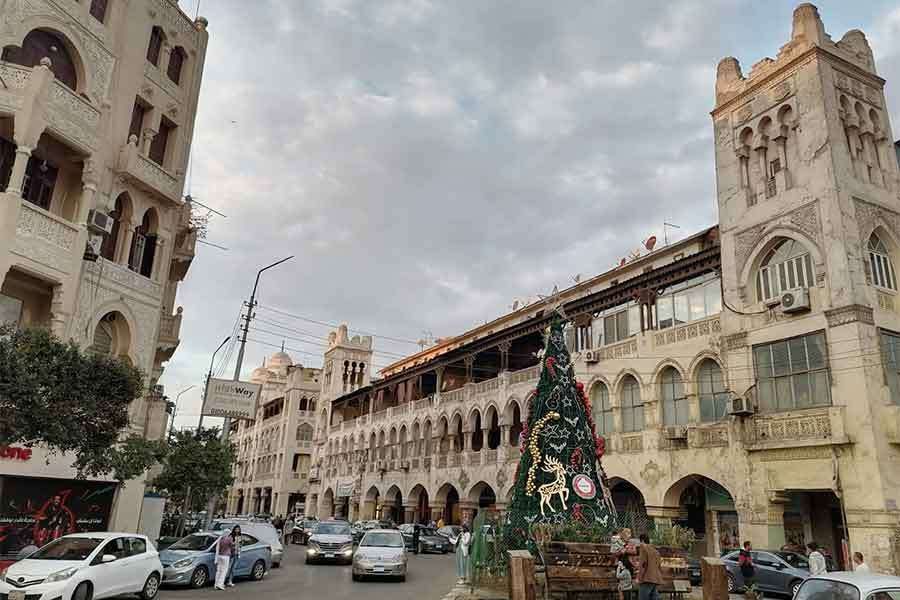
## Description **El Korba Square**, located in the historic district of **Heliopolis (Masr El Gedida)**, is one of Cairo’s most architecturally distinctive and socially vibrant urban spaces. Unlike the medieval fabric of Islamic Cairo or the colonial density of Downtown, El Korba represents a **unique fusion of European town planning, Moorish revival architecture, and early 20th-century cosmopolitan lifestyle**. It is widely regarded as the **ceremonial heart of Heliopolis**, a neighborhood originally designed as a modern garden city on the northeastern edge of Cairo. The square is surrounded by a remarkable collection of **arcaded buildings**, balconies, domed corner towers, and cream-colored façades that form one of the **largest continuous ensembles of Heliopolis-style architecture in Egypt**. This architectural style blends **Islamic motifs, Andalusian arches, Art Deco symmetry, and European urban planning principles**. The result is an environment that feels at once North African, Mediterranean, and unmistakably Cairene. El Korba’s importance is not purely visual. It functions as a **social engine**. Cafés, pastry shops, restaurants, cinemas, and boutiques line the arcades, creating a space that is active from morning until late at night. Families stroll in the evening, students meet for coffee, office workers pass through during the day, and wedding photographers stage shoots beneath the arches. The square is not a preserved museum zone. It is a **living city room**, constantly shifting in rhythm and purpose throughout the day. Historically, Heliopolis was founded in **1905 by Belgian industrialist Baron Édouard Empain**, who envisioned a modern city in the desert connected to Cairo by electric tram. El Korba became the **symbolic downtown of this new settlement**. Its arcades were designed to provide shade, promote walkability, and unify commercial activity within a visually coherent framework. This concept was decades ahead of its time in Egypt and remains one of the district’s most successful urban legacies. A little-known fact is that several of El Korba’s buildings were originally constructed with **private rooftop gardens and internal ventilation corridors**, engineered to cool interiors naturally before widespread air conditioning. Another lesser-known detail is that the square once hosted **open-air orchestras and formal social promenades** in the early 20th century, modeled after European city squares. Atmospherically, El Korba carries a powerful sense of **nostalgia mixed with everyday vitality**. It is one of the few places in Cairo where early modern urban planning still shapes daily behavior: people walk, sit, linger, watch, and return repeatedly. The square holds emotional weight for generations of residents who associate it with first dates, family outings, late-night conversations, and childhood memories. Unlike Cairo’s grand monuments, El Korba’s beauty lies in **repetition and continuity rather than singular spectacle**. Its arches frame everyday life. Its balconies observe the street silently. Its cafés serve as informal civic institutions. Together, they create one of the rare public environments in Egypt where architecture, commerce, and community remain structurally aligned. ## Location **El Korba Square** is located in the heart of **Heliopolis**, in northeastern Cairo. **City:** Cairo **District:** Heliopolis (Masr El Gedida) **Governorate:** Cairo Governorate **Country:** Egypt The square sits near the intersection of **Baghdad Street, Al-Ahram Street, Ibrahim Al-Laqani Street, and El Merghany Street**. ### How to Get There: * **By metro:** * Take **Line 3** toward **Adly Mansour** and exit at **Heliopolis Square Station** or nearby stations, then walk or take a short taxi ride. * **By taxi or ride-hailing:** The most convenient option from anywhere in Cairo. * **By car:** Available, but parking is limited and traffic is often heavy in the evenings. * **By bus or microbus:** Many public routes serve Heliopolis directly. El Korba is easily combined with visits to **Baron Empain Palace, El Merghany Street, and Heliopolis Sporting Club**. ## Tips * **Visit in the evening:** This is when the square is most vibrant and socially active. * **Daytime is best for photography:** The building details show clearly in natural light. * **Choose arcaded seating:** Many cafés offer shaded outdoor seating under the historic arches. * **Expect traffic at peak hours:** Especially between 6 p.m. and 10 p.m. * **Walk slowly:** El Korba is best experienced on foot, not as a transit zone. * **Try local dessert cafés:** Traditional Egyptian pastry shops are a major highlight. * **Respect the residential nature:** Many upper floors are still private homes. * **Avoid weekends if you prefer quiet:** Fridays and Saturdays can become very crowded. ## Conclusion **El Korba Square** is the emotional and architectural center of Heliopolis, a space where **early modern urban vision still shapes daily life in contemporary Cairo**. With its graceful arcades, steady pedestrian rhythm, and deep social memory, El Korba offers something rare in Egypt’s megacity environment: **a walkable, human-scaled public square that works both historically and socially**. ## FAQ **1. What is El Korba Square known for?** It is known for its **Heliopolis-style architecture, arcaded buildings, cafés, and vibrant social life**. **2. When was El Korba developed?** It was developed in the **early 20th century**, shortly after the founding of Heliopolis in 1905. **3. Is El Korba tourist-friendly?** Yes, though it remains primarily a **local social hub rather than a mass tourism site**. **4. Is there an entrance fee?** No. It is a **public square open at all times**. **5. Is El Korba suitable for families?** Yes. It is especially popular for **evening family walks and casual dining**. **6. Can El Korba be visited with Baron Palace on the same trip?** Yes. They are located **within short walking or driving distance of each other**. ## Links * [Egyptian Ministry of Tourism](https://www.experienceegypt.eg/en)
GemVoyage Team • World
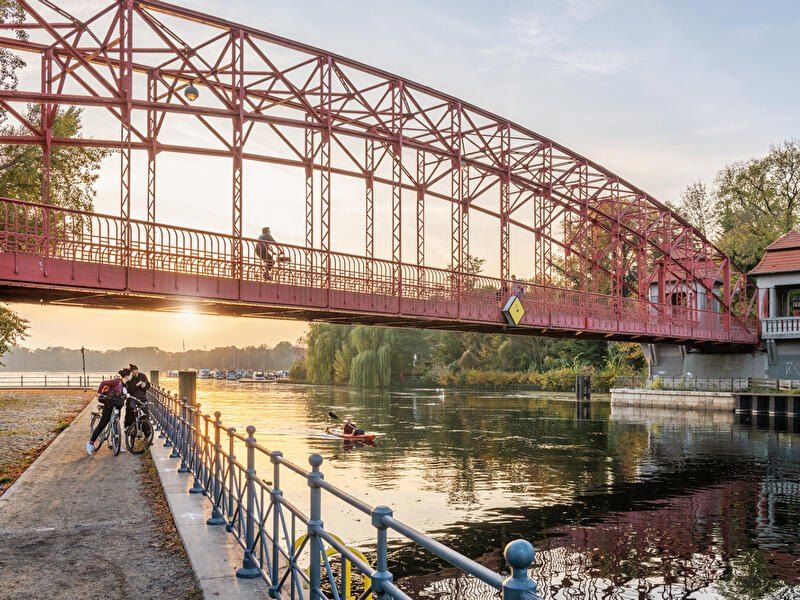
Berlin
## Description **Tegeler See** is one of Berlin’s largest and most beloved lakes, offering a rare combination of **deep forest landscapes, wide open water, historic promenades, and recreational freedom** within a major European capital. Unlike the carefully curated parks of central Berlin, Tegeler See feels **expansive, natural, and quietly powerful**, a place where the city dissolves into wind, water, and tree canopy. The lake stretches across the northern edge of Berlin and forms part of a much larger **interconnected water system** linking rivers, canals, and smaller lakes. Its shoreline alternates between **elegant promenades, dense woodland, sandy bathing areas, hidden coves, and small harbors**, giving every section a distinct character. On one walk you might pass joggers and cyclists near cafés, and moments later find yourself alone on a forested shoreline with only birds and passing sailboats for company. What makes Tegeler See especially unique is its **scale and visual openness**. The lake is wide enough to feel almost coastal in certain sections. Wind patterns shape large ripples across the surface, and on clear days the sky reflects endlessly into the water. Sailboats, paddleboards, kayaks, ferries, and swimmers all share the same space, creating an ever-moving ecological and recreational system. The western and northern edges of the lake are bordered by the **Tegel Forest (Tegeler Forst)**, one of Berlin’s largest continuous woodland zones. This forest contains long hiking paths, wildlife corridors, thick pine stands, and historic hunting routes that once served Prussian royalty. This direct interface between **urban lake and protected forest** is one of Tegeler See’s defining strengths. Few European capitals offer this scale of natural immersion without leaving city limits. From an urban perspective, the lake is closely tied to the borough of **Reinickendorf** and the historic district of **Alt-Tegel**. The Alt-Tegel promenade along the eastern shoreline functions as a social spine, lined with restaurants, ice cream shops, boat docks, beer gardens, and terraces overlooking the water. This area transforms in summer into one of Berlin’s most relaxed outdoor social scenes, blending families, cyclists, couples, and long-term residents. A little-known fact is that Tegeler See was once part of the **Havel River’s natural floodplain system**, and its modern form is the result of long-term hydraulic engineering dating back centuries. Another lesser-known detail is that the famous German poet and philosopher **Gotthold Ephraim Lessing** once lived near the lake, and the nearby Tegel Palace was home to the Humboldt family, including **Alexander von Humboldt**, one of history’s most influential natural scientists. Tegeler See’s emotional identity is shaped by **seasonality**. In spring, the forest releases fresh green layers and migrating birds return. Summer brings swimming, paddleboarding, lakeside dining, and long evening sunsets. Autumn covers the surrounding hills in gold and copper tones. Winter transforms the lake into a minimalist landscape of cold light, mist, and silence, occasionally frozen at the edges. Unlike Berlin’s central landmarks, Tegeler See does not present itself as a destination of spectacle. Its appeal is built on **duration rather than intensity**. People do not come for a single photo; they come to spend hours walking, reading, boating, cycling, swimming, and simply existing beside water and forest. It is one of the few places in Berlin where **time visibly slows down**. In a city often defined by density, history, and cultural pressure, Tegeler See functions as a **pressure valve**. It absorbs excess motion and releases calm. ## Location **Tegeler See** is located in **northwestern Berlin**, primarily within the borough of **Reinickendorf**, near the historic district of **Tegel**. **City:** Berlin **State (Region):** Berlin **Country:** Germany **Primary Area:** Reinickendorf / Alt-Tegel ### How to Get There: * **By S-Bahn:** * Take **S25** to **Tegel Station**, then walk 10 minutes to the lakeside. * **By U-Bahn:** * Take **U6** to **Alt-Tegel**, which places you directly at the main promenade. * **By bus:** Multiple bus routes connect Tegel with central and northern Berlin. * **By bicycle:** A well-developed bike network connects Tegeler See to the city center. * **By car:** Parking is available but is limited on busy summer days. The lake is easily combined with visits to **Alt-Tegel old town, Tegel Forest hiking trails, and the Havel River network**. ## Tips * **Visit on weekdays if you prefer quiet:** Weekends can be very busy in summer. * **Walk both the promenade and the forest side:** Each offers a completely different experience. * **Bring swimwear in summer:** Designated bathing areas are popular and well maintained. * **Sunset is the most atmospheric time:** Especially from western shoreline viewpoints. * **Boat rentals are widely available during the warm season.** * **Dress for wind:** The open water creates noticeable temperature shifts. * **Combine with Alt-Tegel dining:** Lakeside restaurants are a core part of the experience. * **Winter visits are underrated:** The silence and mist create a dramatic, cinematic mood. ## Conclusion **Tegeler See** is Berlin at its most expansive and elemental. It is where the city trades architecture for horizon, traffic for water movement, and density for breathing space. By uniting forest, lake, promenade, and history into one continuous landscape, Tegeler See offers a version of Berlin that is **slower, wider, and deeply restorative**. ## FAQ **1. Is Tegeler See suitable for swimming?** Yes. Several **official bathing areas** operate during the summer season. **2. Can you rent boats on Tegeler See?** Yes. **Paddleboats, kayaks, and small sailboats** are available for rent. **3. Is Tegeler See family-friendly?** Yes. It is widely used by **families, cyclists, walkers, and swimmers**. **4. How long does it take to walk around Tegeler See?** Walking the full perimeter can take **2.5 to 4 hours**, depending on pace and route. **5. Is Tegeler See good in winter?** Yes, especially for **quiet walks, photography, and forest exploration**. **6. Is there wildlife around the lake?** Yes. The area supports **water birds, foxes, deer, and diverse forest species**. ## Links * [Visit Berlin](https://www.visitberlin.de)
GemVoyage Team • World
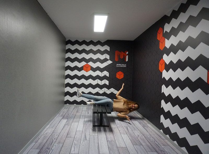
Milan
## Description The **Museo delle Illusioni – MDI** in Milan is a contemporary museum designed to challenge the viewer’s understanding of **vision, perception, spatial logic, and cognitive bias**. Unlike traditional museums that focus on historical artifacts or fine arts, MDI operates at the intersection of **science, psychology, and interactive entertainment**, offering an environment where visitors actively participate in the experience rather than observe passively. The space is filled with **optical illusions, perspective rooms, rotating installations, holograms, paradox structures, and sensory challenges** that push visitors to reconsider how the brain interprets visual information. Every room is intentionally constructed to distort scale, depth, orientation, and movement. The museum’s core idea is simple but effective: **what you see is not always what exists**, and the brain can be easily misled when context changes. What differentiates Milan’s MDI from similar illusion museums elsewhere is its emphasis on **sleek design and technical precision**. Installations are engineered with high production quality and clean aesthetics consistent with Milan’s reputation as a design capital. The lighting, angles, and surfaces are calibrated to deliver strong photographic effects, making the museum particularly popular among visitors who enjoy **creative photography and social media content**. Many exhibits demonstrate foundational principles of **Gestalt psychology, neuroscience, and geometry**, though without overwhelming visitors with complex scientific language. The goal is to make scientific concepts **intuitive, experiential, and playful**. By physically stepping into illusions, visitors experience cognitive phenomena that are normally confined to textbooks or laboratory experiments. A little-known fact is that several rooms in the museum use **forced perspective techniques** originally borrowed from early film production and Renaissance stage design. Another interesting detail is that some of the illusions at MDI come from a global research network of visual-perception experts who continually update the installations based on emerging cognitive science findings. Emotionally, the museum operates on a gradient between surprise and curiosity. Children laugh at rooms where gravity seems reversed, adults puzzle over patterns that appear to move, and groups experiment with depth tricks to produce impossible photographs. The museum’s strength lies in its ability to make **intellectual play accessible**, bridging the gap between learning and entertainment. MDI is not a large museum, and it does not intend to be. Its impact comes from **concentration, novelty, and careful choreography**. A visit typically moves quickly, but the density of experiences ensures that visitors remain mentally engaged throughout. In a city known for design excellence, the Museo delle Illusioni offers a refreshing and contemporary counterpoint: an environment where **visual culture becomes an interactive game**, and where perception becomes the main exhibit. ## Location The **Museo delle Illusioni – MDI** is located in the central area of Milan, close to major attractions and easily accessible on foot or by public transport. **City:** Milan **Region:** Lombardy (Lombardia) **Country:** Italy **Address Area:** Near **Porta Venezia** and the **Corso Buenos Aires** district ### How to Get There: * **By metro:** * **M1 (Red Line)** to **Porta Venezia**; the museum is a short 5–7 minute walk. * **By tram:** Various tram lines stop along Corso Venezia and Via Palestro. * **By bus:** Several city buses serve the area around Porta Venezia. * **By car:** Parking is limited and often busy; public transport is strongly recommended. * **On foot:** The museum is easily combined with strolls through **Giardini Indro Montanelli** and nearby galleries. Its central location makes it convenient to pair with shopping, dining, or museum visits in the same outing. ## Tips * **Pre-book tickets:** The museum is popular and time slots fill quickly, especially on weekends. * **Bring a fully charged phone or camera:** Many installations are designed for interactive photography. * **Visit during off-peak hours:** Early afternoons on weekdays offer the best conditions for photos without crowds. * **Expect a short but dense visit:** Most people spend **45–75 minutes** inside. * **Some illusions require participation:** Be ready to pose, experiment, and move around. * **Families will find the space especially engaging:** The illusions work well for children and adults alike. * **Check for rotating exhibits:** Some temporary installations appear seasonally. ## Conclusion The **Museo delle Illusioni – MDI in Milan** delivers an intelligent, playful, and visually rich exploration of how the mind constructs reality. With its polished installations, scientific underpinnings, and strong interactive component, it stands out as one of the city’s most modern cultural experiences. It offers not only entertainment, but also a clear reminder that **perception is fundamentally subjective**. ## FAQ **1. How long does a typical visit take?** Most visitors spend **about one hour** exploring the installations. **2. Is the museum suitable for children?** Yes. It is highly **family-friendly**, with exhibits designed for all ages. **3. Do I need to book in advance?** Yes. **Online reservation** is recommended to secure preferred time slots. **4. Can I take photos inside?** Absolutely. Photography is encouraged, and many rooms are designed for it. **5. Is the museum accessible?** Most areas are accessible for visitors with reduced mobility, though some illusions may be difficult to experience physically. **6. Is it crowded?** It depends on the time and day. **Weekends and holidays** are the busiest. ## Links * [Museo delle Illusioni – Milan Official Website](https://moimilano.it/en/)
GemVoyage Team • World
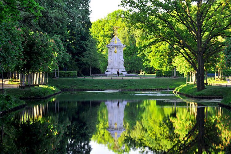
Berlin
## Description Großer Tiergarten (commonly called the Tiergarten) is Berlin’s largest and most beloved inner-city park—a leafy, varied landscape of walking paths, ponds, monuments, and quiet glades sitting at the historic heart of the city. Once a ducal hunting ground, it evolved over centuries into a landscaped public park designed for civic leisure and grand promenades. Today, the Tiergarten provides a verdant contrast to Berlin’s urban fabric: classical statues, the iconic Victory Column (Siegessäule), and gardened lawns mix with dense tree stands and serene waterways. What distinguishes the Tiergarten is its adaptability: it serves as a place for brisk joggers, picnickers, history buffs, and families alike. Hidden corners contain wartime memorials and modern sculptures, while open meadows host festivals and local gatherings. A lesser-known fact is that parts of the park were extensively redesigned after World War II and partially replanted to counter wartime damage, which explains the deliberate blend of older avenues with mid-20th-century layout decisions. ## Location Großer Tiergarten is located in central Berlin, within the Mitte borough and adjacent to important city landmarks such as the Brandenburg Gate, the Reichstag, and Potsdamer Platz. The park stretches roughly from the Brandenburg Gate in the east toward the Bellevue Palace in the west. Getting there: Tiergarten is highly accessible. Most visitors arrive via Berlin’s U-Bahn or S-Bahn (Brandenburger Tor station, Tiergarten station, or Potsdamer Platz). Buses and trams also serve nearby stops. Cycling is an excellent way to traverse the park—bike rental stations are plentiful, and dedicated paths make for a pleasant ride. If arriving by car, use nearby parking facilities at major crossroads, though public transport is recommended. ## Tips - Plan a walking loop: Combine a visit to the Brandenburg Gate, stroll through the Tiergarten, and finish at the Victory Column or Bellevue Palace. - Rent a bike: The park is large and easier to explore by bicycle; watch for pedestrians on mixed-use paths. - Bring a picnic: Large grassy areas are perfect for relaxing; be mindful of local rules about barbecues and cleanup. - Visit different times: Morning for joggers and birdwatching; late afternoon for softer light and fewer crowds; summer evenings often have informal gatherings or small concerts. - Check memorials and monuments: Allow time to see the Soviet War Memorial, the Bismarck statue, and other historical markers—each has its own backstory worth exploring. - Accessibility: Main routes are generally flat and wheelchair-friendly, but some wooded paths can be uneven. ## Conclusion Großer Tiergarten is a green heart in the center of Berlin: historically layered, naturally restorative, and culturally active. Whether you seek a peaceful walk, a cycling route, or a place to sit and watch Berlin life unfold, Tiergarten delivers a balanced urban park experience with historical depth and modern vitality. ## FAQ Q: Is the Tiergarten safe to visit after dark? A: Central areas and main paths are generally safe, but as with any large park, avoid isolated areas at night and use common-sense precautions. Q: Can I cycle in the Tiergarten? A: Yes. Cycling is popular and convenient with dedicated paths; always yield to pedestrians and follow local cycling rules. Q: Are there guided tours of the Tiergarten? A: Guided walking and bike tours that include Tiergarten are available through various tour operators; check Berlin tourism listings. Q: Is the Victory Column accessible to the public? A: The Victory Column is open to visitors who want to climb to the viewing platform; check opening hours and ticketing information. ## Links - [Visit Berlin – Tiergarten information](https://www.visitberlin.de/en/place/grosser-tiergarten)
GemVoyage Team • World
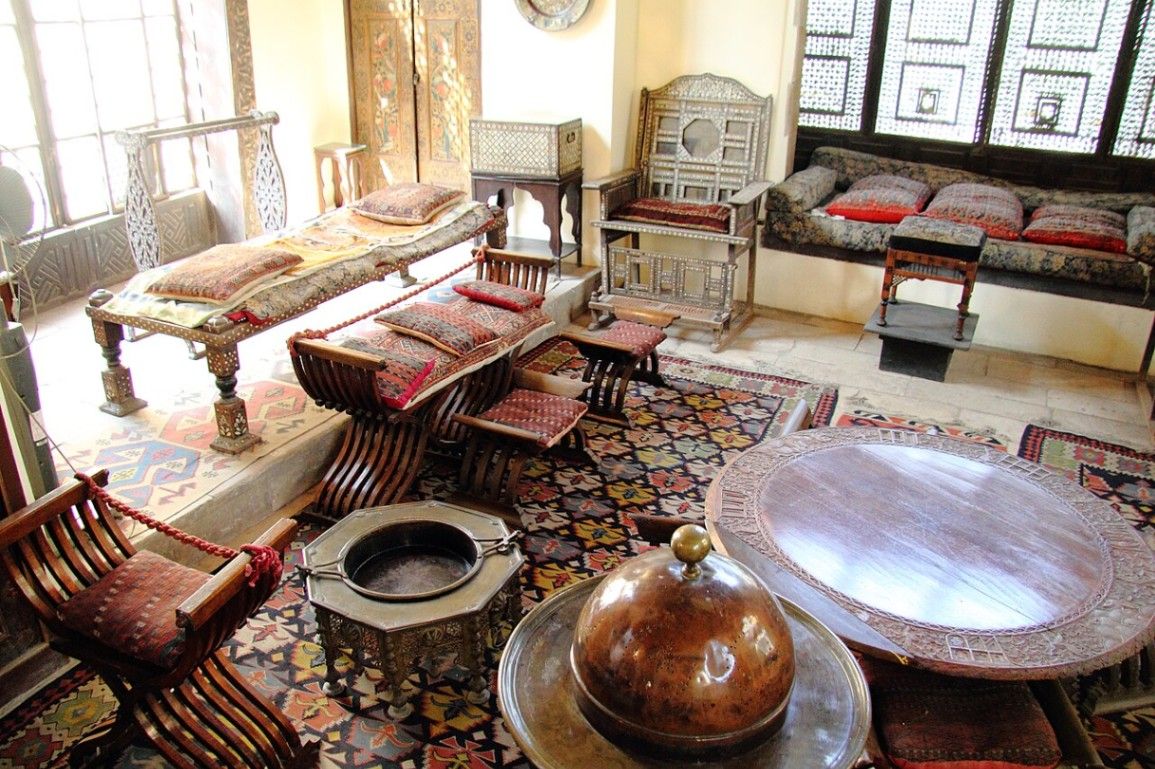
Cairo
## Description Tucked away in the heart of historic **Cairo**, beside the magnificent **Ibn Tulun Mosque**, lies one of Egypt’s most enchanting and well-preserved heritage houses — the **Gayer-Anderson Museum** (Arabic: **بيت الكريتلية**, *Beit al-Kritliyya*). This remarkable museum offers a captivating journey into the world of **Islamic architecture, art, and domestic life**, transporting visitors back to the golden centuries of Cairo’s past. The museum is named after **Major R.G. Gayer-Anderson**, a British army officer, physician, and passionate collector who lived in Cairo in the 1930s. Fascinated by Egyptian and Islamic culture, he restored and furnished two adjoining 16th–17th century Ottoman-era houses — **Beit al-Kritliyya** and **Beit Amna bint Salim** — creating a living museum that preserves the elegance and sophistication of old Cairo homes. Inside, the museum unfolds as a labyrinth of **beautifully decorated rooms, wooden mashrabiya screens, marble courtyards, and intricately carved ceilings**. Each space tells a story: from the **Harem Room** with its intimate lattice windows, to the **Persian Room** adorned with exquisite carpets and calligraphy, and the **Damascus Room**, with its painted wood panels imported from Syria. The collection itself is a treasure trove — **antique furniture, carpets, glassware, manuscripts, Islamic ceramics, and artworks** gathered from Egypt, the Middle East, and beyond. One of the most striking displays is the **Pharaonic Room**, showcasing Gayer-Anderson’s fascination with ancient Egypt, including a replica of the famous **Gayer-Anderson Cat**, whose original is housed in the British Museum. A lesser-known fact is that the house is believed to be built on an ancient **Nilometer** (a device used to measure the Nile’s water levels), and local legends claim it once stood on the site of a **temple to Hathor**, the ancient Egyptian goddess of love and beauty. The building itself also served as a filming location for the **James Bond film “The Spy Who Loved Me” (1977)**, giving it a touch of cinematic fame. With its combination of **Islamic elegance, artistic detail, and historical charm**, the Gayer-Anderson Museum remains one of Cairo’s most atmospheric — yet often overlooked — attractions, offering a rare glimpse into Egypt’s layered cultural identity. ## Location The **Gayer-Anderson Museum** is located in the **Sayyida Zeinab district** of **Cairo**, Egypt, right beside the **Ibn Tulun Mosque**, one of the city’s oldest and most beautiful mosques. **Address:** Ahmed Ibn Tulun Street, Sayyida Zeinab, Cairo, Egypt To get there: * **By metro:** Take the **Cairo Metro Line 1** to **Saad Zaghloul** or **Sayyida Zeinab Station**, then a short taxi or tuk-tuk ride to Ibn Tulun Mosque. * **By taxi or ride app:** Simply tell the driver *“Beit al-Kritliyya near Ibn Tulun Mosque.”* It’s a well-known heritage site. * **By walking:** If you’re exploring **Islamic Cairo**, it’s a 15–20 minute walk from **Sultan Hassan Mosque** or **Al-Rifa’i Mosque**. * **By tour:** Many guided tours of Islamic Cairo include the museum as part of their itinerary. ## Tips * **Visit in the morning:** The museum is quieter and cooler in the early hours, allowing for a peaceful exploration of its rooms and courtyards. * **Pair your visit with Ibn Tulun Mosque:** The two sites are adjacent, and their architectural harmony makes for an ideal cultural outing. * **Take a guided tour:** The museum’s exhibits are best appreciated with context — a local guide can explain the symbolism behind each room and object. * **Photography:** Allowed in most areas (check current policy), but flash is often prohibited. Bring a camera for the stunning interiors. * **Look for the mashrabiya windows:** These wooden lattice screens were designed for privacy and ventilation — an essential feature of Islamic domestic architecture. * **Wear comfortable shoes:** You’ll walk through narrow staircases and multiple levels, so flat shoes are recommended. * **Visit nearby sites:** The **Citadel of Salah al-Din**, **Sultan Hassan Mosque**, and **Khan el-Khalili Bazaar** are all within short driving distance. ## Conclusion The **Gayer-Anderson Museum** is one of Cairo’s most captivating cultural landmarks — a living time capsule of Islamic art, architecture, and tradition. Blending Egyptian, Ottoman, and Persian influences, it embodies the cosmopolitan soul of Cairo through centuries of history. Whether you’re an art lover, a history enthusiast, or simply a curious traveler, wandering through the rooms of **Beit al-Kritliyya** is like stepping into another era — one where craftsmanship, elegance, and storytelling merge beautifully under the Cairo sun. ## FAQ **1. Who was Gayer-Anderson?** Major **R.G. Gayer-Anderson** was a British officer and collector who lived in Cairo in the 1930s and transformed two Ottoman-era houses into the museum we see today. **2. What is special about the museum?** It combines **Islamic architecture, antique collections, and traditional Egyptian home design**, offering an authentic look at life in old Cairo. **3. When was the museum established?** The houses date back to the **16th and 17th centuries**, and the museum officially opened to the public in **1945**. **4. Where is the museum located?** It’s beside the **Ibn Tulun Mosque** in the **Sayyida Zeinab district** of Cairo. **5. What are the museum’s opening hours?** Typically open daily from **9:00 AM to 5:00 PM**, though times may vary during Ramadan or national holidays. **6. Can I take photos inside?** Photography is generally allowed for a small additional fee; flash photography may be restricted in some rooms. **7. What nearby attractions can I visit?** The **Ibn Tulun Mosque**, **Citadel of Salah al-Din**, **Sultan Hassan Mosque**, and **Khan el-Khalili Bazaar** are all close by. ## Links * [Egyptian Ministry of Tourism and Antiquities – Official Site](https://egymonuments.gov.eg) * [Gayer-Anderson Museum Information](https://egymonuments.gov.eg/museums/gayer-anderson-museum)
GemVoyage Team • World
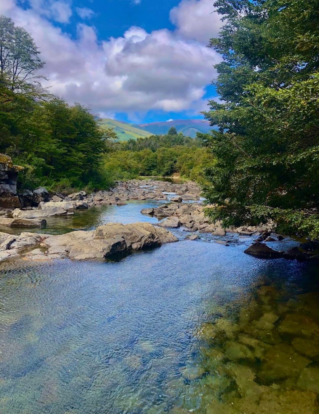
Neuquén
## Description Nestled within the heart of Argentina’s Patagonia, **Cascadas del Río Hermoso** is a breathtaking natural wonder that captivates visitors with its unspoiled beauty. The waterfalls are part of the Río Hermoso, which translates to “Beautiful River,” and the name is no exaggeration. Surrounded by dense forests, clear mountain air, and the soothing sound of rushing water, this destination offers a perfect blend of serenity and adventure. What makes Cascadas del Río Hermoso unique is not only its picturesque setting but also its relative tranquility compared to more popular sites like Iguazú Falls. Here, you won’t find large crowds or bustling tourist infrastructure—just raw, pristine nature. The waterfalls are small to medium in size, cascading down in multiple tiers, forming natural pools that invite visitors to rest and reflect. A little-known fact is that the river is fed by meltwater from the Andes, meaning that the water levels and flow change significantly with the seasons. Another detail often overlooked is the region’s rich biodiversity: the surrounding forests are home to species such as the Patagonian woodpecker and the elusive pudú, one of the world’s smallest deer. For nature enthusiasts, Cascadas del Río Hermoso is a rare opportunity to encounter untouched ecosystems. ## Location Cascadas del Río Hermoso is located in **Argentina, in the Neuquén Province of northern Patagonia**, within the boundaries of **Lanín National Park**. The closest town is **San Martín de los Andes**, a charming Patagonian village known for its alpine-style architecture, lakes, and outdoor activities. To get there, travelers usually fly into Aviador Carlos Campos Airport, just 20 km from San Martín de los Andes. From the town, the waterfalls can be reached by car via **Ruta Nacional 40** and then **Ruta Provincial 63**, which winds through stunning Andean landscapes. The trip itself is a highlight, with panoramic views of lakes, mountains, and valleys. Renting a car is highly recommended, as it allows for flexible stops at scenic viewpoints along the way. ## Tips * **Best Time to Visit**: Late spring to early autumn (November to March) offers the best weather and water flow. Winter can be beautiful too but access may be more difficult due to snow. * **What to Bring**: Comfortable hiking shoes, layered clothing (Patagonia weather is unpredictable), water, snacks, and a camera. * **Respect Nature**: Since this is a less-visited area, maintaining its pristine condition is important. Avoid leaving trash and stick to marked trails. * **Combine Your Trip**: Consider combining your visit with nearby attractions like Lake Lácar, Chapelco ski resort, or even the famous Seven Lakes Route. * **Local Guides**: Hiring a local guide can enrich your experience with stories about the region’s history, culture, and flora and fauna. ## Conclusion Cascadas del Río Hermoso is a tranquil, hidden treasure in Argentina’s Patagonia, offering visitors a rare chance to connect with untouched nature. Surrounded by forests, wildlife, and the pure waters of the Andes, it’s a destination that rewards travelers seeking peace, adventure, and authenticity. ## FAQ **1. How difficult is the hike to Cascadas del Río Hermoso?** The hike is considered easy to moderate. Most trails are well-marked and accessible, making it suitable for families and casual hikers. **2. Is swimming allowed in the river or waterfalls?** Yes, swimming is possible in some of the natural pools, especially during the summer months, though the water can be very cold due to glacial origins. **3. Are there entrance fees?** Since Cascadas del Río Hermoso is part of Lanín National Park, a small entrance fee may apply, depending on the season and visitor category. **4. Can I visit Cascadas del Río Hermoso year-round?** Yes, but accessibility varies. Summer and spring are ideal, while winter may present challenges due to snow-covered roads. **5. Are there facilities near the waterfalls?** Facilities are limited. Visitors should bring their own supplies, although San Martín de los Andes has plenty of options for food, lodging, and equipment rentals. ## Links * [Neuquén Province Tourism](https://www.argentina.travel/en/province/neuquen)
GemVoyage Team • World