Discover extraordinary places shared by our community of travelers
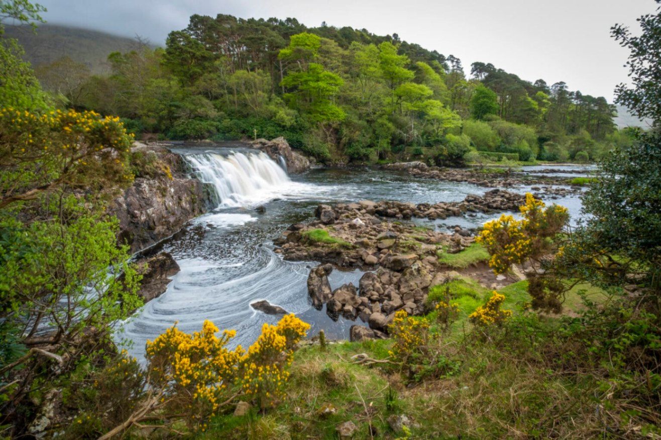
Connacht
## Description **Aasleagh Falls** is one of Ireland’s most quietly dramatic natural sights, where freshwater from the Connemara mountains meets the tidal waters of Killary Harbour. Unlike towering waterfalls designed to impress through height alone, Aasleagh Falls is defined by **movement, light, and setting**. Its power and appearance change constantly depending on rainfall, tide levels, and weather conditions, making every visit slightly different. The waterfall is formed by the **Erriff River**, which descends rapidly over smooth rock shelves just before flowing into Killary Harbour, Ireland’s only fjord. At high tide, seawater pushes upriver, partially submerging the lower cascades and creating a rare visual effect where fresh and saltwater interact. At low tide, the falls appear more forceful and exposed, revealing multiple channels and textures in the rock. What makes Aasleagh Falls particularly special is its **sense of isolation and scale relative to its surroundings**. Backed by rugged mountains and often framed by mist or low clouds, the falls feel far removed from modern life despite being accessible by road. A lesser-known fact is that the area around the falls has long been a **salmon fishing site**, and anglers can sometimes be seen working the waters nearby. Another overlooked detail is that the name “Aasleagh” is derived from Irish, roughly translating to a “rocky place,” a fitting description of the terrain shaped by water over millennia. Aasleagh Falls is not fenced, ticketed, or curated. It exists as it always has: exposed, elemental, and dependent on nature rather than infrastructure. This rawness is central to its appeal. ## Location **Country:** Ireland **Province:** Connacht **County:** Mayo **Nearby Area:** Leenane / Killary Harbour Aasleagh Falls is located at the eastern end of **Killary Harbour**, near the border between County Mayo and County Galway, in one of Ireland’s most scenic regions. ### How to Get There * **By car:** * From Westport, drive toward Leenane via the N59. The falls are located just before entering the village and are visible from the roadside. * **By bus:** * Limited rural bus services operate in the area; schedules are infrequent and not ideal for flexible visits. * **On foot or by bicycle:** * Possible if staying nearby, but weather and narrow roads should be considered. There is no formal parking lot; roadside pull-ins are commonly used. ## Tips * **Visit after rainfall:** The falls are most impressive following heavy rain. * **Check the tide:** Low tide reveals more of the cascade structure. * **Wear waterproof footwear:** The ground can be wet and uneven. * **Be cautious near the edge:** There are no safety barriers. * **Combine with scenic drives:** The surrounding roads offer some of Ireland’s best coastal and mountain views. * **Bring a camera:** Light conditions change rapidly and can be spectacular. ## Conclusion Aasleagh Falls is a powerful example of Ireland’s understated natural beauty. Its shifting form, dramatic setting, and lack of commercialization make it ideal for visitors seeking authenticity, solitude, and a deeper connection with the landscape. ## FAQ **1. Is there an entrance fee to Aasleagh Falls?** No, access is completely free. **2. How tall is the waterfall?** It is relatively low in height, but wide and dynamic rather than vertical. **3. When is the best time to visit?** After rainfall and during low tide for the most dramatic views. **4. Is it suitable for children?** Yes, with close supervision due to the lack of barriers. **5. Can you swim near the falls?** Swimming is not recommended due to strong currents and tidal influence. **6. How long should I plan to stay?** Around **20 to 30 minutes**, longer if photographing or exploring the area. ## Links * [Discover Ireland](https://www.discoverireland.ie/)
GemVoyage Team • World
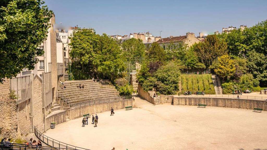
Paris
## Description **Arènes de Lutèce** is one of Paris’s most unexpected and historically significant sites: a **Roman amphitheater hidden in plain sight** within the Latin Quarter. Dating back to the **1st century CE**, it is among the oldest surviving monuments in the city and a rare physical reminder of Lutetia, the Gallo-Roman settlement that preceded modern Paris. Unlike the grand, fully preserved amphitheaters of southern France or Italy, the Arènes de Lutèce is fragmentary, modest in scale, and deeply embedded in its urban surroundings. This is precisely what makes it compelling. The remains include portions of the arena floor, tiered seating, subterranean chambers, and traces of the stage wall. In its prime, the amphitheater could accommodate **up to 15,000 spectators**, hosting gladiatorial combats, animal hunts, and theatrical performances. What sets the Arènes de Lutèce apart is its **history of disappearance and rediscovery**. After the fall of the Roman Empire, the structure was gradually dismantled and buried beneath medieval buildings. By the Middle Ages, its existence was largely forgotten. It was not rediscovered until the 19th century during urban works, and even then, much of it was threatened by redevelopment. The site was ultimately saved following public campaigns supported by prominent cultural figures, including Victor Hugo. A lesser-known fact is that the amphitheater served multiple secondary purposes over time. During the Middle Ages, stones from the structure were reused in nearby buildings, effectively dissolving it into the fabric of the city. Another overlooked detail is that today’s visible remains represent **only a fraction** of the original structure; much of it still lies beneath surrounding streets and buildings, preserved underground rather than reconstructed. Today, the Arènes de Lutèce functions as a **public space rather than a formal museum**. Locals play pétanque on the arena floor, children run along the ancient stone seating, and visitors sit quietly where Roman spectators once gathered. This coexistence of daily life and antiquity is rare in Paris and gives the site a lived-in authenticity that no curated exhibition could replicate. ## Location **Country:** France **Region:** Île-de-France **City:** Paris **Arrondissement:** 5th (Latin Quarter) The Arènes de Lutèce is located between Rue Monge and Rue de Navarre, in one of Paris’s most historic and intellectually rich neighborhoods. ### How to Get There * **By metro:** * Line 7 to **Place Monge**, then a 3–5 minute walk. * Line 10 to **Cardinal Lemoine**, followed by a short walk. * **By bus:** * Several bus lines serve the Latin Quarter and stop nearby. * **On foot:** * Easily reachable from the Panthéon, Jardin des Plantes, or the Seine’s Left Bank. * **By bicycle:** * Bike lanes and public bike stations are available in the area. ## Tips * **Visit during quiet hours:** Early mornings or weekdays offer a calmer atmosphere. * **Bring context with you:** There is minimal on-site interpretation; prior reading enhances appreciation. * **Respect the space:** It is both a historical site and a neighborhood park. * **Look for subtle details:** Notice the stonework and seating curves to visualize the original structure. * **Combine with nearby landmarks:** The Latin Quarter offers exceptional historical density within walking distance. * **Photography is allowed:** But be mindful of locals using the space. ## Conclusion The Arènes de Lutèce is a rare example of ancient history woven directly into the rhythm of modern urban life. Quiet, understated, and profoundly authentic, it offers a powerful reminder that Paris did not begin in the Middle Ages, but in the Roman world beneath its streets. ## FAQ **1. Is there an entrance fee?** No, entry to the Arènes de Lutèce is free. **2. How old is the amphitheater?** It dates back to the 1st century CE. **3. How long should I spend there?** Around **20 to 40 minutes**, depending on interest. **4. Is it a reconstructed site?** No, it consists of original remains with minimal restoration. **5. Is it suitable for children?** Yes, it is an open and informal space often used by families. **6. Why is it not better known?** Its modest size and lack of monumental reconstruction keep it off many tourist itineraries. ## Links * [Paris tourism official site](https://parisjetaime.com/eng/)
GemVoyage Team • World
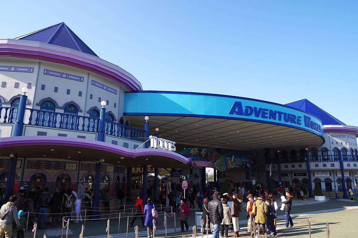
Shirahama
## Description Adventure World in Japan is a one-of-a-kind destination that seamlessly blends the excitement of an amusement park with the wonder of a zoo and the serenity of an aquarium. Located in the coastal town of Shirahama, Wakayama Prefecture, this sprawling complex offers a full day—or more—of entertainment for families, animal lovers, and thrill-seekers alike. What makes Adventure World truly unique is its immersive approach to connecting humans, animals, and nature, all under the motto of “Smile for Everyone.” The park is especially famous for its giant panda breeding program, which is the most successful outside of mainland China. Adventure World has bred more pandas than any other facility in Japan, and visitors can observe these beloved creatures in the “Panda Love” zone, where they roam freely in spacious enclosures. The park is also home to dolphins, sea lions, flamingos, elephants, and even cheetahs, all housed in thoughtfully designed habitats. A little-known fact: Adventure World operates as the Japanese branch of the Chengdu Giant Panda Research Base, and its panda ambassadors have even been appointed as mascots for traffic safety campaigns in Wakayama Prefecture. Another quirky detail—visitors can rent golf carts to explore the Safari World zone, provided they have a valid Japanese or international driver’s license. ## Location Adventure World is located in **Japan**, within the **Kansai Region**, in the town of **Shirahama**, **Wakayama Prefecture**. The park sits near the Pacific coast, offering scenic views and easy access to other local attractions like Shirahama Beach and the Sandanbeki cliffs. ### How to Get There: - **By Train**: Take the JR Limited Express Kuroshio from Shin-Osaka Station to Shirahama Station (approx. 2.5 hours). From there, it’s a 20-minute bus ride to the park. - **By Air**: Fly into Nanki-Shirahama Airport, which is just a 5-minute drive from Adventure World. - **By Car**: From Osaka, it’s about a 2.5-hour drive via the Hanwa Expressway. Parking is available on-site. Its proximity to both the airport and train station makes it a convenient destination for domestic and international travelers. ## Tips for Visitors To make the most of your visit to Adventure World, consider these tips: - **Arrive Early**: The park opens at 10:00 AM, and arriving early helps you beat the crowds and catch the morning animal feedings. - **Buy Tickets Online**: Advance purchase is recommended to avoid long lines and ensure availability, especially during weekends and holidays. - **Don’t Miss the Shows**: The dolphin and sea lion performances are crowd favorites and showcase impressive aquatic acrobatics. - **Use the Safari Kart**: If you have a valid license, rent a golf cart to explore the Safari World zone—it’s fun and saves time. - **Pack Light**: The park is large, so wear comfortable shoes and bring essentials like sunscreen, water, and a camera. - **Explore the Food Options**: From themed cafés to local Wakayama cuisine, there’s a variety of dining choices inside the park. ## Conclusion Adventure World is a vibrant fusion of wildlife, entertainment, and education. With its world-class panda program, thrilling rides, and interactive animal zones, it offers a joyful and enriching experience for visitors of all ages. Whether you're traveling solo or with family, this park is a must-see gem in southern Japan. ## FAQ **1. What are the opening hours of Adventure World?** Typically, the park is open from 10:00 AM to 5:00 PM. Hours may vary seasonally. **2. Is Adventure World suitable for young children?** Yes, the park is family-friendly with attractions and animal zones designed for all age groups. **3. Can I interact with animals at the park?** Yes, there are designated areas where you can feed or observe animals up close, including capybaras, giraffes, and penguins. **4. Are there any multilingual services available?** Basic English signage is available, but guided tours are primarily in Japanese. It’s helpful to download a translation app. **5. Is there a discount for group or family tickets?** Yes, group rates and family packages are available. Check the official website for details. **6. Can I bring my own food into the park?** Outside food is generally not allowed, but there are plenty of dining options inside. ## Links - [Adventure World Official Website](https://www.aws-s.com/en) - [Adventure World – Wikipedia](https://en.wikipedia.org/wiki/Adventure_World_%28Japan%29)
GemVoyage Team • World
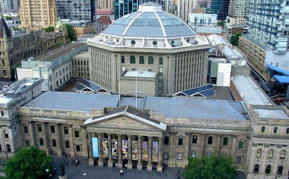
Melbourne
## Description State Library Victoria is more than just a library—it’s a cultural icon, architectural marvel, and a vibrant public space in the heart of Melbourne. Established in 1854, it holds the distinction of being Australia’s oldest public library and one of the first free libraries in the world. Today, it’s also one of the busiest, welcoming millions of visitors each year who come not only to read, but to explore exhibitions, attend events, and marvel at its historic interiors. The library’s crown jewel is the La Trobe Reading Room, a stunning octagonal chamber topped with a majestic domed ceiling. With its white balconies, timber desks, and natural light streaming through the dome, it’s a favorite spot for students, artists, and photographers. Beyond its beauty, the library houses over five million items, including rare manuscripts, maps, photographs, and artworks. Highlights include Ned Kelly’s original armor and the Jerilderie Letter, offering a glimpse into Australia’s bushranger folklore. A little-known fact: the library was originally envisioned as a combined museum, gallery, and library. Its founder, Sir Redmond Barry, also laid the foundation stone for the University of Melbourne on the same day as the library’s cornerstone. Another quirky detail—one of the library’s permanent exhibitions includes a collection of human hair, part of a broader exploration of Victorian-era curiosities. ## Location State Library Victoria is located in **Australia**, in the **state of Victoria**, within the city of **Melbourne**. The library sits prominently at **328 Swanston Street**, right in the Central Business District (CBD), making it easily accessible and surrounded by shops, cafés, and cultural landmarks. ### How to Get There: - **By Train**: The nearest station is Melbourne Central, just across the street. Flinders Street Station is also within walking distance. - **By Tram**: Multiple tram lines stop at the Swanston Street and La Trobe Street intersection, right outside the library. - **By Foot**: If you’re exploring the CBD, the library is a short walk from Bourke Street Mall and the State Parliament. - **By Bike**: Melbourne’s bike lanes and shared paths make cycling to the library a breeze. Bike racks are available nearby. Its central location makes it a perfect starting point for a day of cultural exploration in Melbourne. ## Tips for Visitors To make the most of your visit to State Library Victoria, keep these tips in mind: - **Join a Guided Tour**: Free tours are available and offer fascinating insights into the library’s history, architecture, and collections. - **Visit the Dome Galleries**: Located above the La Trobe Reading Room, these galleries host rotating exhibitions and provide stunning views of the dome. - **Check the Events Calendar**: From author talks to creative workshops, the library hosts a wide range of public programs. - **Use the Free Wi-Fi**: Ideal for remote work or study sessions in a beautiful setting. - **Explore the Cowen Gallery**: This gallery showcases Australian art and historical portraits, often overlooked by casual visitors. - **Respect Quiet Zones**: While the library is lively, some areas are designated for silent study—be mindful of signage. ## Conclusion State Library Victoria is a dynamic blend of history, learning, and public engagement. Whether you're diving into research, admiring its architecture, or simply relaxing in the reading room, the library offers a rich and inspiring experience in the heart of Melbourne. ## FAQ **1. Is there an entrance fee to visit State Library Victoria?** No, entry is free for all visitors. **2. What are the library’s opening hours?** Typically, Monday to Thursday: 10 AM – 9 PM; Friday to Sunday: 10 AM – 6 PM. Galleries close at 5 PM daily. **3. Can I take photos inside the library?** Yes, photography is allowed in most public areas, but flash and tripods are discouraged. **4. Is the library suitable for children?** Absolutely. There are dedicated children’s areas and family-friendly events throughout the year. **5. Are food and drinks allowed inside?** Food and drinks are not permitted in reading rooms but are allowed in designated areas. **6. Does the library offer research assistance?** Yes, librarians are available to help with research, and there are dedicated tools for family history and academic inquiries. ## Links - [State Library Victoria – Wikipedia Overview](https://en.wikipedia.org/wiki/State_Library_Victoria)
GemVoyage Team • World
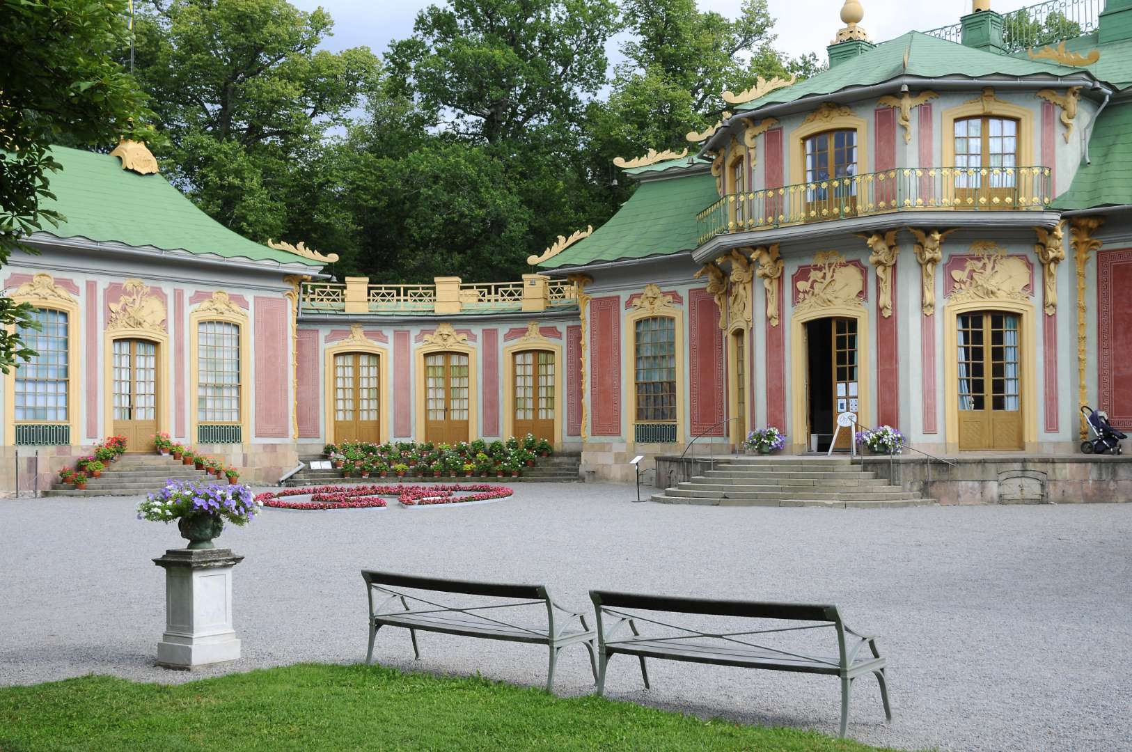
Stockholm
## Description The Chinese Pavilion (Swedish: Kina slott) in Stockholm is a whimsical and elegant slice of 18th-century European fascination with the East. Nestled within the lush grounds of Drottningholm Palace Park, this royal summer retreat was commissioned in 1753 by King Adolf Fredrik as a surprise birthday gift for Queen Lovisa Ulrika. The pavilion is a stunning example of **Chinoiserie**, a European artistic style that romanticized and imitated Chinese design, blending it with Rococo elements to create a fairy-tale-like structure. What makes the Chinese Pavilion truly unique is its blend of imported Chinese artifacts and Swedish craftsmanship. Inside, you’ll find original Chinese silk and paper wall coverings, lacquered screens, porcelain vases, and stained glass windows. Swedish Rococo furniture inspired by Chinese motifs adds a local twist to the exotic aesthetic. The pavilion’s interiors were designed by Jean Eric Rehn, the royal court’s chief supervisor, and many of the decorative objects were brought in by the Swedish East India Company. A little-known fact: the original pavilion was prefabricated in Stockholm and assembled in Drottningholm in secret, making it one of the earliest examples of modular architecture in Sweden. Another quirky detail—during the pavilion’s unveiling, the young Crown Prince Gustav (later King Gustav III) presented the Queen with a golden key while dressed as a Chinese mandarin. ## Location The Chinese Pavilion is located in **Sweden**, within the **Stockholm County** region, specifically in the **Ekerö Municipality** on the grounds of **Drottningholm Palace**, a UNESCO World Heritage Site. ### How to Get There: - **By Public Transport**: Take the metro to Brommaplan, then transfer to bus 176 or 177 toward Drottningholm. The pavilion is a short walk from the palace. - **By Boat**: During summer, ferries run from central Stockholm to Drottningholm—a scenic and relaxing option. - **By Car**: It’s about a 30-minute drive from downtown Stockholm. Parking is available near the palace grounds. Once you arrive at Drottningholm, follow the signs through the park to reach the Chinese Pavilion. ## Tips for Visitors To make the most of your visit to the Chinese Pavilion, consider these helpful tips: - **Visit in Summer**: The pavilion is open from May to September. Plan your visit during this period to access the interiors. - **Combine with Drottningholm Palace**: Make it a full-day outing by exploring both the palace and the pavilion. - **Guided Tours**: Opt for a guided tour to learn about the history, architecture, and royal anecdotes tied to the pavilion. - **Photography**: The exterior and gardens are perfect for photos, but interior photography may be restricted. - **Wear Comfortable Shoes**: The pavilion is located within a large park, so expect some walking. - **Check for Events**: Occasionally, cultural events and exhibitions are held in the pavilion—check the schedule in advance. ## Conclusion The Chinese Pavilion in Stockholm is a captivating blend of East and West, fantasy and history. With its ornate design, rich backstory, and tranquil setting, it offers visitors a unique glimpse into Sweden’s royal past and its 18th-century fascination with Chinese art and culture. ## FAQ **1. When is the Chinese Pavilion open to visitors?** It’s open seasonally from May to September. Exact dates may vary each year. **2. Is the Chinese Pavilion part of Drottningholm Palace?** Yes, it’s located within the Drottningholm Palace Park and is considered part of the Royal Domain. **3. Can I visit the pavilion without a guided tour?** Yes, self-guided visits are allowed, but guided tours provide deeper insight into its history and design. **4. Is photography allowed inside the pavilion?** Photography is generally restricted inside. You can take pictures of the exterior and gardens. **5. How long should I plan for the visit?** Allocate at least 1–2 hours to explore the pavilion and surrounding park, or more if combining with Drottningholm Palace. **6. Is the pavilion accessible for people with mobility issues?** Accessibility is limited due to the historic nature of the building. Contact the site in advance for specific accommodations. ## Links - [Official Chinese Pavilion Page – Royal Palaces of Sweden](https://www.kungligaslotten.se/english/royal-palaces-and-sites/the-chinese-pavilion.html) - [Visit Stockholm – Chinese Pavilion](https://www.visitstockholm.com/o/the-chinese-pavilion/)
GemVoyage Team • World
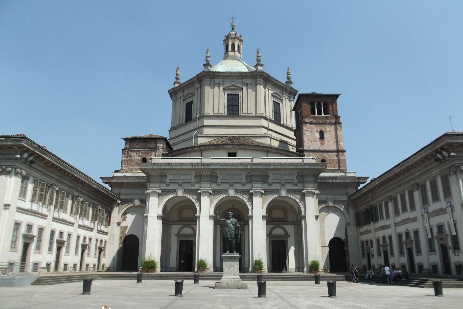
Milan
## Description The Basilica of San Lorenzo Maggiore in Milan is one of the city’s oldest and most architecturally intriguing churches, offering a rich tapestry of history, religion, and design. Originally constructed between the late 4th and early 5th centuries, the basilica has undergone numerous reconstructions, resulting in a unique blend of Early Christian, Renaissance, and Baroque styles. Its imposing central dome and symmetrical layout make it a standout among Milan’s ecclesiastical landmarks. What sets San Lorenzo apart is its daring architectural originality. Art historians have noted its resemblance to the great churches of Constantinople, many of which no longer exist. The basilica’s interior features elegant marble columns, intricate mosaics, and the stunning Chapel of Saint Aquilino, which houses 4th-century Byzantine mosaics and remnants of Roman construction materials. Outside, the Colonne di San Lorenzo—sixteen Roman columns dating from the 3rd century—stand as a dramatic prelude to the church and are among the few surviving relics of ancient Mediolanum. A little-known fact: archaeological investigations suggest that the basilica may have been built atop a Roman amphitheater, and some of its foundational materials were repurposed from other Roman sites. Another fascinating detail is that the basilica’s dedication to Saint Lawrence was only confirmed in 590 AD, long after its initial construction. ## Location The Basilica of San Lorenzo Maggiore is located in **Italy**, in the **Lombardy region**, within the **city of Milan**. Its exact address is **Corso di Porta Ticinese, 39**, situated near the medieval Porta Ticinese and within walking distance of the Navigli district and the city center. ### How to Get There - **By Metro**: Take Line M2 to Sant’Ambrogio or Line M3 to Missori, then walk about 10–15 minutes. - **By Tram**: Tram line 3 stops at “Ticinese Molino delle Armi,” just steps from the basilica. - **By Foot**: From the Duomo, it’s a pleasant 15-minute walk through historic streets. - **By Bike or Scooter**: Milan’s bike-sharing and e-scooter services offer a scenic and efficient way to reach the basilica. Its central location makes it easy to include in a day of sightseeing, especially when paired with nearby attractions like the Basilica of Sant’Eustorgio or the Navigli canals. ## Tips - **Visit the Chapel of Saint Aquilino**: Don’t miss this side chapel, which contains some of the oldest mosaics in Milan and offers a glimpse into the city’s Roman past. - **Go Early or Late**: The basilica is less crowded in the morning or late afternoon, allowing for a more peaceful visit. - **Dress Modestly**: As with all religious sites, respectful attire is recommended. - **Explore the Piazza**: The square in front of the basilica is lively and atmospheric, often filled with street performers and locals. - **Check for Mass Times**: If you’re interested in attending a service, consult the basilica’s schedule in advance. - **Photography**: Photos are allowed, but avoid flash and be mindful during services. ## Conclusion Basilica San Lorenzo Maggiore is a captivating blend of ancient history and spiritual heritage. With its Roman columns, Byzantine mosaics, and architectural grandeur, it offers a compelling experience for anyone exploring Milan’s rich cultural landscape. ## FAQ **1. Is there an entrance fee to visit the basilica?** No, entry to the basilica is free. Donations are welcome. **2. What are the opening hours?** Monday to Friday: 8:00 AM – 12:30 PM and 3:00 PM – 6:30 PM Saturday and Sunday: 9:00 AM – 1:00 PM and 3:00 PM – 7:00 PM **3. Can non-Catholics visit the basilica?** Yes, the basilica is open to all visitors, regardless of religious background. **4. Is the basilica wheelchair accessible?** Some areas may be challenging due to steps and uneven flooring, but the main entrance and nave are generally accessible. **5. Are guided tours available?** Yes, some local tour operators include San Lorenzo in their walking tours of Milan’s historic center. **6. What is the best time of year to visit?** Spring and autumn offer mild weather and fewer crowds, making them ideal for sightseeing. ## Links - [Basilica of San Lorenzo – Wikipedia Overview](https://en.wikipedia.org/wiki/Basilica_of_San_Lorenzo,_Milan) - [San Lorenzo Maggiore – Official Website](http://www.sanlorenzomaggiore.com/)
GemVoyage Team • World
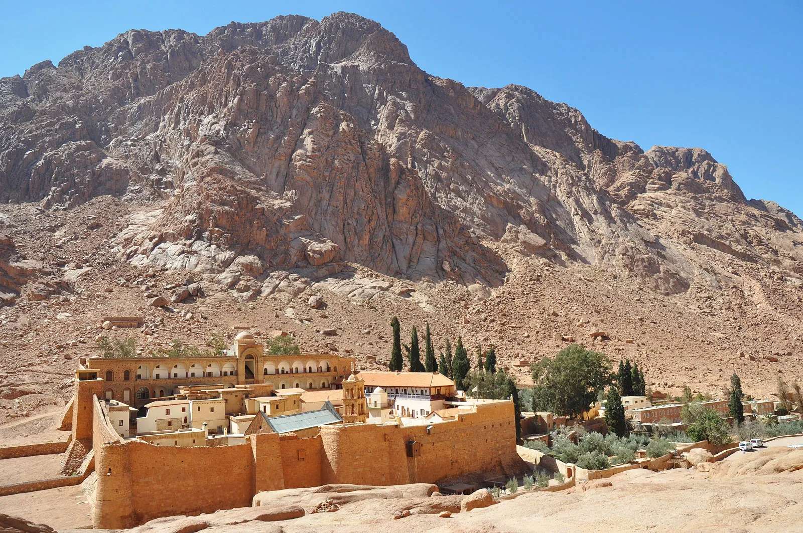
Sinai
## Description Mount Catherine (Jebel Katherîn) is the highest peak in Egypt, rising to an elevation of 2,629 meters (8,625 feet) above sea level. Nestled in the rugged terrain of the southern Sinai Peninsula, this majestic mountain offers not only breathtaking views but also a deep spiritual and historical resonance. It’s named after Saint Catherine of Alexandria, whose remains were said to have been miraculously transported to the summit by angels. Today, it’s a popular destination for hikers, pilgrims, and adventurers seeking solitude, challenge, and connection to ancient traditions. Unlike the more frequented Mount Sinai (Jebel Musa), which is traditionally associated with Moses receiving the Ten Commandments, Mount Catherine is quieter and less commercialized. The summit rewards climbers with panoramic views of the surrounding desert and mountains, often blanketed in snow during winter—a rare sight in Egypt. At the peak, a small chapel dedicated to Saint Catherine stands as a testament to the mountain’s religious significance. A little-known fact: the mountain is part of the Saint Catherine Protectorate, Egypt’s largest nature reserve, which is home to rare flora and fauna, including Nubian ibex and Sinai agamas. Another intriguing detail is that the summit’s chapel is one of the highest Christian shrines in the Middle East. ## Location Mount Catherine is located in **Egypt**, within the **South Sinai Governorate**, near the town of **Saint Catherine**. It lies in the heart of the Sinai Peninsula, surrounded by dramatic granite peaks and desert valleys. ### How to Get There: - **By Car**: From Cairo, it’s approximately a 6–8 hour drive via the Suez Tunnel and through the desert highways. From Sharm El-Sheikh, the drive takes about 3–4 hours. - **By Bus**: Regular buses run from Cairo and Dahab to Saint Catherine town. From there, local guides can arrange transport to the trailhead. - **By Tour**: Many adventure and pilgrimage tours include Mount Catherine in their itinerary, often combined with visits to Mount Sinai and Saint Catherine’s Monastery. It’s recommended to travel with a licensed guide, especially for the hike, as the terrain can be challenging and weather conditions unpredictable. ## Tips for Visitors To make the most of your Mount Catherine experience, consider these tips: - **Start Early**: Begin your hike before dawn to reach the summit by sunrise. The views are spectacular, and temperatures are cooler. - **Hire a Local Guide**: Guides from Saint Catherine town are knowledgeable and can enhance your experience with historical and cultural insights. - **Dress in Layers**: Even in summer, temperatures can drop significantly at higher elevations. Bring warm clothing and sturdy hiking boots. - **Bring Supplies**: Carry water, snacks, a flashlight, and a first aid kit. There are no facilities on the trail. - **Respect the Environment**: The area is ecologically sensitive. Stick to marked paths and avoid littering. - **Visit the Monastery**: Saint Catherine’s Monastery, located nearby, is one of the oldest Christian monasteries in the world and a UNESCO World Heritage Site. ## Conclusion Mount Catherine is a place of awe-inspiring beauty and spiritual depth. Whether you're drawn by its status as Egypt’s highest peak or its sacred legacy, the mountain offers a rewarding journey into nature, history, and reflection. ## FAQ **1. How long does it take to hike Mount Catherine?** The hike typically takes 6–8 hours round trip, depending on your pace and weather conditions. **2. Is Mount Catherine harder to climb than Mount Sinai?** Yes, it’s more challenging due to its elevation and less-developed trails. It’s recommended for experienced hikers. **3. Can I hike Mount Catherine without a guide?** While possible, it’s not advisable. The terrain is remote and can be confusing. A guide ensures safety and enhances the experience. **4. Is there accommodation near Mount Catherine?** Yes, the town of Saint Catherine offers guesthouses and eco-lodges catering to hikers and pilgrims. **5. What’s the best time to visit?** Spring (March–May) and autumn (September–November) offer the best weather. Winter can be cold and snowy, while summer is extremely hot. **6. Are there religious services at the summit chapel?** Occasionally, special services are held, but it’s not staffed regularly. Visitors are welcome to enter and reflect. ## Links - [Saint Catherine’s Monastery – Official Site](https://sinaimonastery.com/index.php/en)
GemVoyage Team • World
England
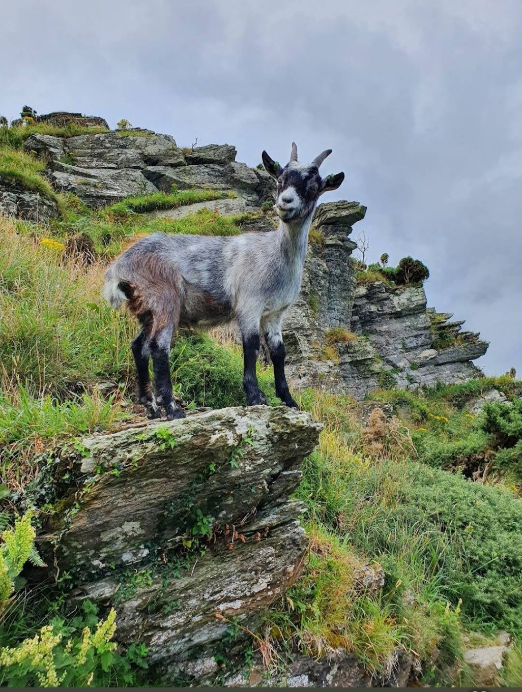
## Description The Valley of Rocks in England is one of North Devon’s most remarkable natural landmarks, known for its dramatic rock formations, sweeping sea views, and intriguing history. Unlike most valleys carved by rivers, the Valley of Rocks is a “dry valley” formed during the Ice Age, making it a rare geological wonder in the UK. Walking through the valley feels like stepping into a mythical landscape. Towering rocks with names like Castle Rock and Ragged Jack rise high above the path, their shapes sparking centuries of local legends. The valley has inspired famous writers such as William Wordsworth and Samuel Taylor Coleridge, who drew upon its dramatic scenery for their poetry. A little-known fact is that the Valley of Rocks was once home to a Victorian cricket ground, possibly one of the most scenic sports fields ever created. While matches no longer take place, the flat ground remains a quirky reminder of the valley’s unusual past. Another fascinating feature is its herd of feral goats, descendants of animals introduced long ago, which continue to roam freely along the cliffs and rocky ledges. This combination of wild beauty, historical curiosities, and literary inspiration makes the Valley of Rocks an unforgettable destination for anyone visiting North Devon. ## Location The Valley of Rocks lies just outside the small town of Lynton, within Exmoor National Park in North Devon, England. Running parallel to the coastline of the Bristol Channel, the valley offers some of the most spectacular sea views in the region. For those traveling by car, the valley is around a 90-minute drive from Exeter or just over an hour from Barnstaple, the nearest major town. Parking is available close to the valley, making it convenient for families and casual walkers. If you’re traveling by public transport, trains connect Exeter to Barnstaple, followed by a bus journey to Lynton. From there, the valley is only a 15–20 minute walk along a coastal path. For a truly unique journey, take the Lynton and Lynmouth Cliff Railway, a Victorian water-powered funicular that links Lynmouth harbor with the clifftop town of Lynton, before strolling out to the valley. ## Tips for Visiting To ensure you make the most of your trip to the Valley of Rocks, consider these practical tips: - Wear sturdy shoes. The paths are rocky and uneven, so comfortable walking shoes are a must. - Bring a camera. From sweeping views over the Bristol Channel to close-up encounters with wild goats, the valley is a photographer’s dream. - Pack a picnic. There are no cafés in the valley itself, but it’s a perfect spot for a scenic outdoor meal. Just watch out for curious goats! - Explore the South West Coast Path. The valley forms part of this famous long-distance trail, so even a short walk gives you access to dramatic coastal scenery. - Check the weather. Coastal winds can be strong, and conditions change quickly. Bring a jacket, even in summer. - Visit nearby towns. Pair your visit with a trip to Lynton and Lynmouth, both known for their charming shops, tea rooms, and coastal views. - Respect wildlife. The feral goats are iconic, but remember they are wild. Admire them from a safe distance. ## Conclusion The Valley of Rocks in England is a true hidden gem of the North Devon coastline, offering a mix of natural wonder, history, and wildlife that few places can match. Whether you’re hiking the cliffs, spotting wild goats, or simply soaking up the coastal views, this unique valley promises an unforgettable experience. A visit here is not just a walk through a landscape but a journey through time, legend, and nature at its most dramatic. ## Frequently Asked Questions - What is special about the Valley of Rocks in England? The Valley of Rocks is unique because it is a dry valley formed during the Ice Age, unlike most valleys carved by rivers. It features dramatic rock formations, sweeping sea views, and wild goats roaming freely along the cliffs. Its unusual geology and rich history make it a must-see attraction in North Devon. - Where exactly is the Valley of Rocks located? The Valley of Rocks is located just outside the town of Lynton, in North Devon, England, within Exmoor National Park. It runs parallel to the Bristol Channel coastline and is easily accessible on foot from Lynton. - How do I get to the Valley of Rocks? You can reach the Valley of Rocks by car from Exeter (about 90 minutes) or Barnstaple (just over an hour). For public transport, take a train from Exeter to Barnstaple, then a bus to Lynton. From Lynton, the valley is a 15–20 minute walk along a coastal path. Another option is the historic Lynton and Lynmouth Cliff Railway, which connects Lynmouth to Lynton. - Are there wild goats in the Valley of Rocks? Yes! One of the valley’s most iconic features is its herd of feral goats, which are descendants of goats introduced centuries ago. They roam freely across the rocks and cliffs, adding to the valley’s wild and rugged charm. - Can you walk through the Valley of Rocks? Absolutely. The valley is popular with walkers of all levels. Short, easy paths allow families and casual visitors to explore, while more challenging trails connect with the South West Coast Path, offering breathtaking views across the sea and cliffs. - What is the best time to visit the Valley of Rocks? The valley is beautiful year-round, but the best time to visit is late spring to early autumn when the weather is milder and the views are clear. Sunset is particularly stunning, as the rocks glow golden in the fading light ## Useful Links for Planning Your Visit If you’d like to learn more about the Valley of Rocks and the surrounding area, these official resources will help you plan your trip: 1. [Valley of Rocks Information](https://www.exmoor-nationalpark.gov.uk/exmoor-for-everyone/things-to-do/the-valley-of-rocks) 2. [Visit Lynton & Lynmouth](https://visitlyntonandlynmouth.com/)
GemVoyage Team • World
Shkodër
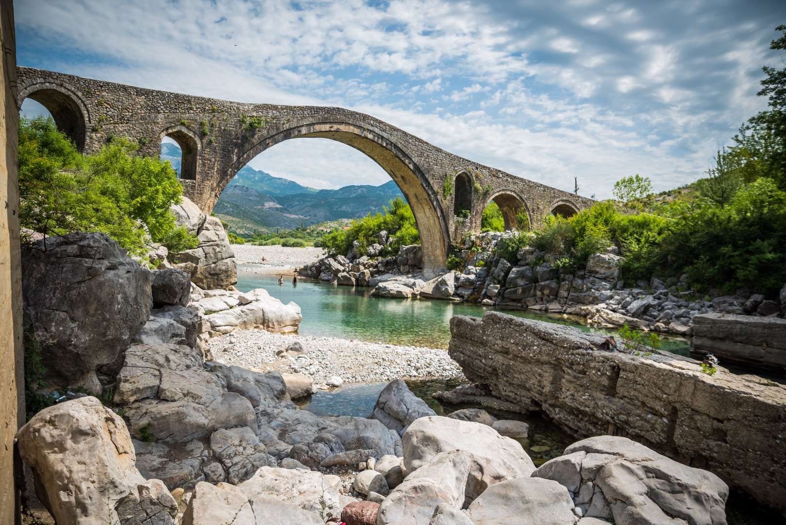
## Description Mesi Bridge (Ura e Mesit), an 18th-century Ottoman-era stone bridge, is one of Albania’s most captivating historical landmarks. Located near the city of Shkodër, this architectural gem spans the Kir River with a graceful series of 13 arches, stretching 108 meters in length. Built around 1770 by Kara Mahmud Bushati, a powerful Ottoman pasha, the bridge was part of a strategic infrastructure project to connect Shkodër with the northern highlands, including the medieval town of Drisht. What makes Mesi Bridge unique is its asymmetrical design and the craftsmanship of its construction. The bridge was built in two phases: the central arch and one adjacent arch were completed first, followed by the remaining eleven. The structure features round river stones and chiseled stone plates, giving it both strength and aesthetic charm. Despite centuries of wear and occasional flooding, the bridge remains remarkably well-preserved and is considered the largest and best-preserved Ottoman bridge in Albania. A little-known fact is that the bridge once formed part of a trade route that extended all the way to Pristina, Kosovo. Another intriguing detail is that the English artist Edward Lear sketched the bridge during his travels in Albania in 1848, captivated by its elegance and the surrounding landscape. ## Location Mesi Bridge is located in **Albania**, in the **Shkodër County**, near the **city of Shkodër**. Specifically, it sits in the village of **Mes**, approximately 5 to 8 kilometers northeast of the city center. ### How to Get There - **By Car**: The most convenient way to reach Mesi Bridge is by car. From Shkodër, follow the road toward the village of Mes. The route is well-marked and passes through scenic countryside. - **By Taxi**: Taxis from Shkodër are affordable and can take you directly to the bridge. - **By Bicycle**: Adventurous visitors can enjoy a leisurely bike ride along quiet rural roads. - **By Public Transport**: Options are limited, so planning ahead is recommended if you’re not driving. The journey itself is part of the experience, offering views of lush greenery, distant mountains, and traditional Albanian villages. ## Tips - **Visit in Spring or Early Summer**: The surrounding landscape is at its most vibrant, and water levels in the Kir River are ideal for photography. - **Wear Comfortable Footwear**: The bridge’s surface is uneven, and exploring nearby trails requires sturdy shoes. - **Bring Water and Sun Protection**: Especially in summer, temperatures can be high and shade is limited. - **Explore Nearby Sites**: Combine your visit with a trip to Drisht Castle or a walk along the Kir Valley. - **Photography**: Early morning or late afternoon offers the best lighting for capturing the bridge and its surroundings. - **Respect the Site**: Though open to the public, the bridge is a protected cultural monument. Avoid climbing on fragile sections. ## Conclusion Mesi Bridge is a stunning example of Ottoman engineering and Albanian heritage. With its elegant arches, historical significance, and picturesque setting, it offers visitors a peaceful and enriching escape just outside Shkodër. ## FAQ **1. Is there an entrance fee to visit Mesi Bridge?** No, the site is free to visit. **2. Can I swim in the Kir River near the bridge?** Yes, swimming is possible, especially in spring and early summer. Water levels may be low in July and August. **3. Is the bridge accessible year-round?** Yes, but heavy rains in winter may make the area muddy or slippery. **4. How long should I plan for the visit?** A visit typically takes 1–2 hours, including time for photos and exploring the surroundings. **5. Is Mesi Bridge suitable for children?** Yes, but supervision is recommended due to uneven surfaces and proximity to the river. **6. Are guided tours available?** Local guides in Shkodër may offer tours that include Mesi Bridge and nearby historical sites. ## Links - [Mesi Bridge – Wikipedia Overview](https://en.wikipedia.org/wiki/Mesi_Bridge) - [VisitShkodër – Mesi Bridge Guide](https://visitshkoder.org/mesi-bridge/)
GemVoyage Team • World