GemVoyage Team • World
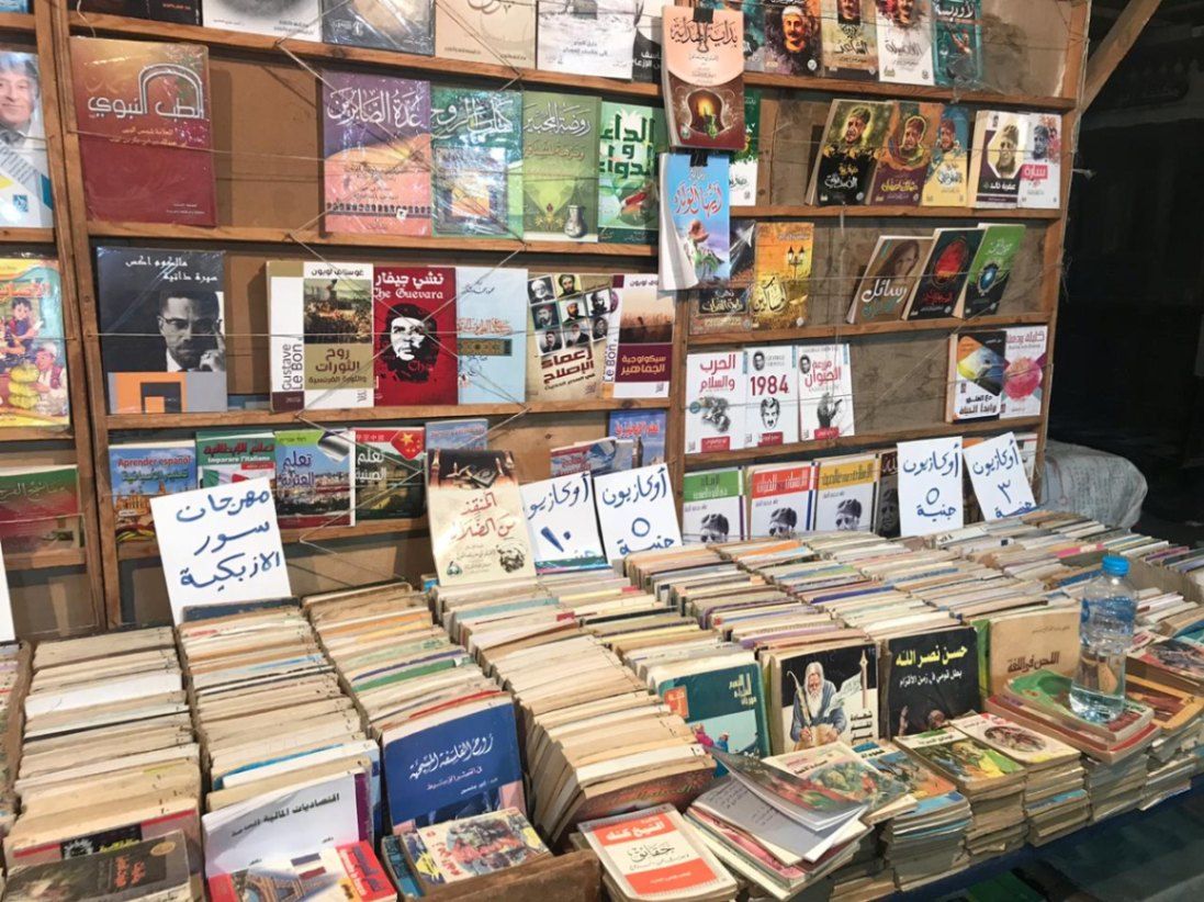
Al-Azbakiyya Wall Book Market, known in Arabic as سور الأزبكية, is one of Cairo’s most distinctive and culturally rich attractions. Located near the historic Azbakeya Gardens, this open-air book market has long been a gathering place for readers, students, and collectors in search of affordable books and rare printed materials. The market is famous for its rows of simple stalls and tables stacked high with books covering every imaginable subject, from classical Arabic literature and religious texts to modern novels, academic works, and children’s books.
What makes Al-Azbakiyya Wall Book Market unique is its role in preserving and circulating literary heritage at accessible prices. Many of the books sold here are second-hand, out-of-print, or rescued from private libraries, making the market a haven for hidden literary gems. A lesser-known fact is that some vendors specialize in vintage magazines, old school textbooks, and early 20th-century publications that are difficult to find elsewhere. Another interesting detail is that the market becomes especially lively during the annual Cairo International Book Fair, when sellers temporarily relocate to fairgrounds while maintaining the spirit of the original market.
Beyond commerce, Sur Al-Azbakiyya represents Cairo’s deep-rooted intellectual culture, offering visitors a chance to engage with the city’s literary soul in an informal and welcoming setting.
Al-Azbakiyya Wall Book Market is located in Egypt, in the Cairo Governorate, within central Cairo. It is situated near Ataba Square, close to the Azbakeya Gardens and within walking distance of several historic and commercial areas.
The market is easily accessible by public transportation. The Ataba Metro Station serves Lines 2 and 3 and is the most convenient way to reach the area. Numerous buses and minibuses also stop nearby. Due to heavy traffic and limited parking, public transport or walking from nearby districts is strongly recommended.
Al-Azbakiyya Wall Book Market is a living cultural institution that reflects Cairo’s love for knowledge, literature, and learning. Whether you are searching for rare books or simply soaking in the atmosphere, it offers a unique and deeply local experience in the heart of the city.
What kind of books can I find at Al-Azbakiyya Wall Book Market?
You can find a wide range of books, including Arabic literature, religious texts, textbooks, novels, magazines, and children’s books.
Are the books new or used?
Most books are second-hand or older editions, though some new and reprinted titles may also be available.
Is the market open every day?
The market is generally open daily, though hours may vary and some stalls close on Fridays.
Can tourists who do not speak Arabic visit?
Yes, visitors are welcome, though knowledge of Arabic helps when browsing and negotiating.
Is photography allowed?
Photography is usually allowed, but it is polite to ask vendors before taking photos.
Discover more hidden gems you might love.
Barcelona
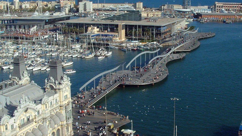
## Description The **Rambla de Mar** is one of Barcelona’s most striking modern promenades — a graceful wooden walkway that stretches across the water, connecting the **end of La Rambla** with the vibrant **Port Vell (Old Port)** area. It’s not only a bridge between land and sea, but also a symbol of **Barcelona’s transformation from an industrial port into a lively, open city by the sea**. Built in **1994** as part of the urban renewal project for the **1992 Olympic Games**, the Rambla de Mar was designed by architects **Helio Piñón** and **Albert Viaplana**. Its name, meaning “Seaside Promenade,” reflects its purpose perfectly — a place where locals and visitors alike can stroll above the Mediterranean, enjoy sea breezes, and admire the city’s modern architecture blended with maritime tradition. What makes the Rambla de Mar unique is its **wavy, undulating design**. The wooden walkway mimics the motion of the sea, while its sleek metal structure allows it to **open and close like a drawbridge**, letting yachts and boats pass through. When the bridge swings open, onlookers often stop to watch, turning a practical feature into a small daily spectacle. At one end of the walkway lies **La Rambla**, Barcelona’s famous tree-lined boulevard full of street performers, cafes, and history. At the other end, you’ll find **Maremagnum**, a modern waterfront complex featuring shops, restaurants, a cinema, and **L’Aquàrium de Barcelona**, one of Europe’s largest aquariums. The Rambla de Mar offers **panoramic views** of Port Vell, the **Columbus Monument**, and the **Montjuïc hill** in the distance — making it a perfect spot for photography, sunset walks, or simply pausing to enjoy the rhythm of Barcelona’s coastal life. Few visitors realize that the Rambla de Mar is also one of the few bridges in Barcelona that **moves several times a day**, timed to allow sailing boats from the marina to enter and exit. Its elegant engineering and maritime setting make it a beloved symbol of Barcelona’s connection to the sea. ## Location The **Rambla de Mar** is located in **Barcelona**, in the **Catalonia (Catalunya)** region of **Spain**, linking **La Rambla** and **Port Vell** at the city’s southern waterfront. **Address:** Moll d’Espanya, 08039 Barcelona, Spain To get there: * **By metro:** Take **L3 (Green Line)** to **Drassanes Station**; from there, it’s a short walk past the **Columbus Monument** toward the water. * **By bus:** Several lines stop at **Portal de la Pau** or **Passeig de Colom**. * **By foot:** Walk straight down **La Rambla** until you reach the waterfront — the wooden walkway begins just beyond the Columbus Monument. * **By bike or scooter:** The **Port Vell** area is bike-friendly, with rentals and parking nearby. * **By taxi or car:** Parking is available at **Maremagnum Shopping Center**, accessible via the bridge. ## Tips * **Visit at sunset:** The light reflecting off the sea and city skyline creates unforgettable views — perfect for photos. * **Watch the bridge open:** The Rambla de Mar opens several times daily to let boats pass; check the **Port Vell schedule** for times. * **Explore Maremagnum:** After your stroll, enjoy dining or shopping at the nearby **Maremagnum complex**, open 365 days a year. * **Visit L’Aquàrium de Barcelona:** Located right at the end of the bridge, it’s a family favorite and one of the top aquariums in Europe. * **Take a harbor cruise:** Small boats and catamarans depart from nearby piers for short scenic trips around the port. * **Enjoy the breeze:** The wooden deck and open sea air make this one of the most relaxing walking spots in the city. * **Combine with La Rambla:** Start your journey from **Plaça de Catalunya** and walk all the way down to the sea for the full Barcelona experience. ## Conclusion The **Rambla de Mar** perfectly captures Barcelona’s spirit — a city where **art, architecture, and the sea coexist in harmony**. Its elegant design, maritime setting, and lively surroundings make it much more than just a bridge; it’s a space where people meet, relax, and enjoy the rhythm of coastal life. Whether you’re heading to Maremagnum for dinner, watching the boats glide by, or catching the golden hour over the harbor, Rambla de Mar offers a uniquely peaceful side of this vibrant Mediterranean city. ## FAQ **1. What is Rambla de Mar?** Rambla de Mar is a **modern wooden pedestrian bridge** that connects **La Rambla** with **Port Vell** in Barcelona. **2. When was it built?** It was completed in **1994**, as part of the city’s transformation for the **1992 Olympic Games**. **3. What is special about its design?** Its **wavy wooden structure** mimics the movement of the sea, and it **opens like a drawbridge** to allow boats to pass. **4. Where does Rambla de Mar lead?** It connects the end of **La Rambla** to the **Maremagnum Shopping Center** and **Barcelona Aquarium** in Port Vell. **5. Can I walk across it at night?** Yes, the bridge is **open 24 hours** and beautifully illuminated at night. **6. Is there an entrance fee?** No — the Rambla de Mar is **free to access**. **7. How long is the walkway?** It stretches roughly **380 meters**, offering scenic views of the sea and marina. ## Links * [Barcelona Tourism Official Site](https://www.barcelonaturisme.com)
GemVoyage Team • World
Karachi
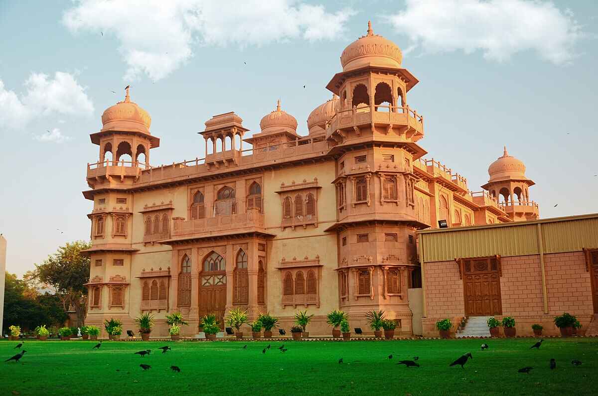
## Description Mohatta Palace is one of Karachi’s most iconic architectural gems, blending history, culture, and artistry into a single breathtaking experience. Built in 1927 by Shivratan Chandraratan Mohatta, a wealthy Hindu Marwari businessman, the palace was originally intended as a summer retreat. Designed by architect Agha Ahmed Hussain, it showcases the Indo-Saracenic style, combining elements of Mughal and Rajasthani architecture. The structure is made of pink Jodhpur stone and local yellow Gizri stone, giving it a warm, regal glow that stands out in the heart of Clifton. The palace spans over 18,500 square feet and features nine domes, intricately carved windows, floral motifs, and a grand central dome that crowns the building. Inside, visitors find polished teak wood staircases, long corridors, and stately rooms that once hosted lavish gatherings. Today, Mohatta Palace functions as a museum, hosting exhibitions that celebrate Pakistan’s rich artistic and cultural heritage—from miniature paintings and textiles to contemporary art installations. A little-known fact: the palace once housed a private temple dedicated to Lord Shiva on its rooftop terrace, a quiet reminder of its original owner's spiritual life. Another intriguing detail is the presence of secret underground tunnels, rumored to have been used for discreet movement during political unrest—though these remain closed to the public. ## Location Mohatta Palace is located in **Karachi**, the largest city in **Pakistan**, within the **Sindh** province. Specifically, it sits in the upscale neighborhood of **Old Clifton**, at 7 Hatim Alvi Road, Block 5. ### How to Get There: - **By Car**: Easily accessible via Shahrah-e-Faisal or the Clifton Bridge. Parking is available nearby. - **By Public Transport**: Local buses and ride-hailing services like Careem and Uber can drop you off directly at the entrance. - **From Jinnah International Airport**: The palace is about a 45-minute drive depending on traffic. For tourists, hiring a local guide or joining a heritage tour can enhance the experience with historical context and insider stories. ## Tips for Visitors To make the most of your visit to Mohatta Palace, keep these tips in mind: - **Check Exhibition Schedules**: The museum hosts rotating exhibitions, so check ahead to catch something that aligns with your interests. - **Photography**: While photography is allowed in the gardens, it’s restricted inside the museum. Ask staff for permission if you're documenting your visit. - **Dress Comfortably**: The palace grounds are expansive, and Karachi’s climate can be warm—light clothing and comfortable shoes are recommended. - **Visit Early**: Arriving early helps avoid crowds and gives you time to explore the gardens and nearby attractions. - **Guided Tours**: Opt for a guided tour to uncover stories and architectural details you might otherwise miss. - **Cultural Etiquette**: Respect the museum’s quiet ambiance and avoid loud conversations or disruptive behavior. ## Conclusion Mohatta Palace is more than a historical building—it’s a living museum that bridges the past and present of Pakistan’s cultural identity. With its stunning architecture, rich history, and vibrant exhibitions, it offers a unique and enriching experience for anyone visiting Karachi. ## FAQ **1. What are the opening hours of Mohatta Palace?** Typically, the museum is open from 11:00 AM to 6:00 PM, Tuesday to Sunday. It’s closed on Mondays and public holidays. **2. Is there an entry fee?** Yes, a nominal fee is charged for entry. Discounts may be available for students and groups. **3. Can I take photos inside the palace?** Photography is allowed in the gardens but restricted inside the museum. Always check with staff before taking pictures. **4. Are guided tours available?** Yes, guided tours are available and highly recommended for a deeper understanding of the palace’s history and exhibitions. **5. Is Mohatta Palace wheelchair accessible?** Accessibility is limited due to the historic nature of the building. It’s best to contact the museum in advance for specific accommodations. **6. What kind of exhibitions are held at Mohatta Palace?** Exhibitions range from traditional arts and crafts to contemporary visual art, often highlighting themes of heritage, identity, and social change. ## Links - [Mohatta Palace Official Website](https://mohattapalacemuseum.org/) - [Wikipedia – Mohatta Palace](https://en.wikipedia.org/wiki/Mohatta_Palace)
GemVoyage Team • World
New York
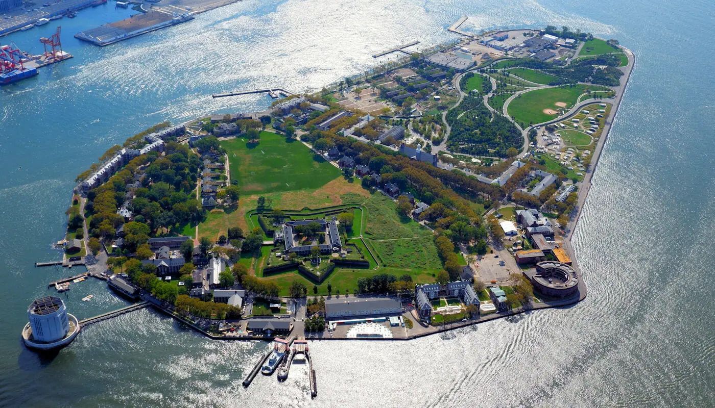
## Description Governors Island is one of New York City's best day trip destinations because it combines harbor views, historic buildings, open green space, and a sense of distance from the city without actually leaving it. The island feels spacious and refreshing in a way that is rare in Manhattan, making it appealing to visitors who want a slower rhythm, bike paths, and outdoor relaxation. The experience is especially strong in warm weather, when the ferry ride itself becomes part of the outing and the skyline views are at their most memorable. What makes Governors Island particularly interesting is that it has moved from a former military and administrative site to a public destination with recreation, arts, and heritage uses. A lesser-known fact is that much of the island's character comes from its reuse: old structures now sit alongside lawns, paths, and public programming. Another detail many first-time visitors appreciate is how easy it is to build a flexible day there, whether you want to picnic, explore, rent bikes, or simply enjoy the harbor air. ## Location Governors Island is in New York Harbor, just south of Manhattan in the United States. It is reached by ferry from designated terminals in Manhattan and sometimes Brooklyn, depending on the season and service schedule. Because access is by boat, the visit naturally feels like a break from the city. The short ride is part of what makes the island appealing and memorable. The best way to visit is to check ferry times ahead of time and plan enough hours on the island to make the crossing worthwhile. Once there, the grounds are easy to explore on foot or by bike. It is one of the most straightforward and rewarding day trips in the New York area. ## Tips - Check the ferry schedule before you go so you can make the most of your time on the island. - Bring food, water, or a picnic plan if you want to enjoy the green space more fully. - Rent a bike if you want to see more of the island without spending the whole day walking. - Go in good weather if possible, since the outdoor setting is a major part of the appeal. - Bring layers, because harbor breezes can make the island feel cooler than Manhattan. - Leave time for skyline views on the return ferry, which are often one of the highlights. ## Conclusion Governors Island is one of the easiest ways to feel removed from New York City while still being within sight of it. Its combination of history, green space, and harbor views makes it an excellent, low-stress escape. ## FAQ ### How do I get to Governors Island? You usually take a ferry from Manhattan or, depending on the season, from Brooklyn. The ferry is simple to use and is part of the experience because it gives you immediate harbor and skyline views. ### Is Governors Island worth visiting for a short trip? Yes, but it is even better if you have several hours. The island's appeal comes from unhurried exploration, open space, and the ferry ride itself, so a longer visit feels more rewarding. ### Can I bike there? Yes, and biking is one of the best ways to cover more ground. The island is well suited to cycling because it is relatively open and easy to navigate. ### Is it family-friendly? Very much so. Families often appreciate the car-free environment, open lawns, and relaxed pace. It is one of the more comfortable outdoor outings in the New York area. ### What should I bring? Water, comfortable walking shoes, sun protection, and perhaps food if you want a picnic. Because the island is such a good open-air destination, it helps to prepare for spending most of the day outside. ## Links - [Official website](https://www.govisland.com/) - [Wikipedia](https://en.wikipedia.org/wiki/Governors_Island)
GemVoyage Team • World
Paris
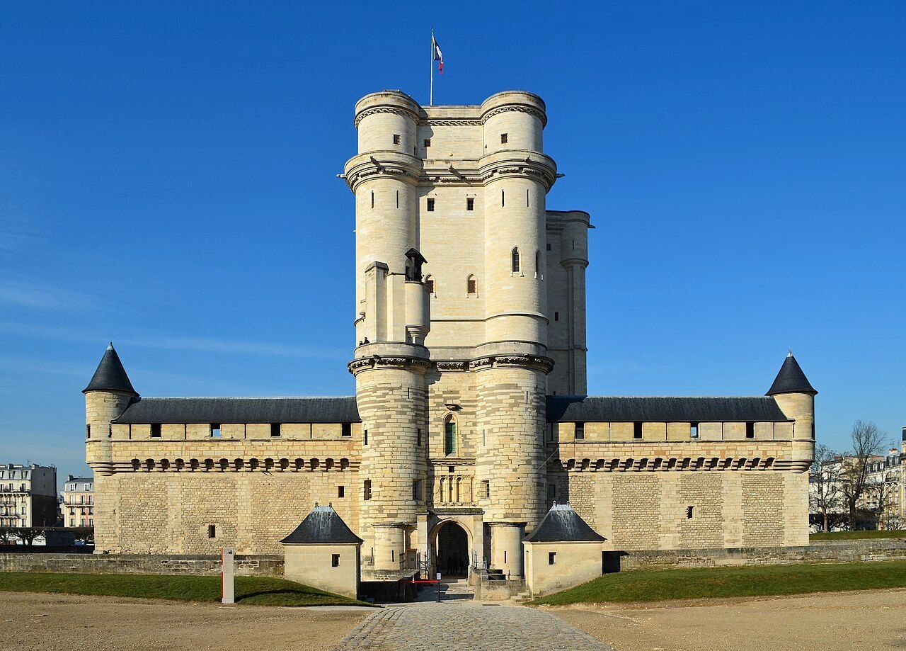
## Description The **Château de Vincennes** is one of France’s most historically significant royal fortresses and a remarkable example of **medieval military architecture** in the heart of modern Paris. Located just east of the city, this vast castle stands as a symbol of the **power, prestige, and evolution of the French monarchy** from the Middle Ages through the Renaissance. Originally built as a **hunting lodge for King Louis VII in the 12th century**, the site was transformed into a formidable **royal fortress** by **King Philip VI** and **King Charles V** during the 14th century. The result was one of Europe’s largest and most impressive medieval castles, complete with towering walls, fortified gates, and a majestic **52-meter (170-foot) keep** — the tallest medieval fortified tower in Europe. The keep, surrounded by a deep moat, served as both a **royal residence** and a **symbol of authority**. Inside, visitors can explore beautifully preserved **royal apartments**, **chapels**, and **ceremonial halls** that once housed some of France’s most powerful monarchs, including **Charles V**, **Henry IV**, and **Louis XIV**. Before Versailles rose to prominence, Vincennes was the main royal residence of the French crown. What makes the Château de Vincennes truly unique is its **dual character** — both royal and defensive. The complex includes a massive **curtain wall with nine towers**, a **drawbridge**, and a **gothic-style chapel** modeled after Sainte-Chapelle in central Paris. Over the centuries, it also served as a **royal prison**, holding famous figures such as **the Marquis de Sade**, **Denis Diderot**, and **Mirabeau**. A lesser-known fact is that the **castle was occupied by Napoleon Bonaparte’s troops**, later used as a **military arsenal**, and even served as a **command center during World War II**. Despite its turbulent past, the site remains remarkably well-preserved and offers a fascinating journey through 800 years of French history. Today, the Château de Vincennes stands as a peaceful yet awe-inspiring monument — less crowded than central Paris landmarks, making it an ideal destination for history enthusiasts seeking authenticity and atmosphere. ## Location The **Château de Vincennes** is located in the **suburb of Vincennes**, directly east of **central Paris**, within the **Val-de-Marne (Île-de-France)** region. It sits adjacent to the **Bois de Vincennes**, Paris’s largest public park. To get there: * **By metro:** Take **Line 1** to **Château de Vincennes Station**, which is just outside the main entrance. * **By RER:** The **RER A** also stops at **Vincennes Station**, about a **5-minute walk** from the castle. * **By bus:** Several Paris bus lines serve the area, including **46, 112, and 114**. * **By car:** Easily accessible via the **Périphérique** (Porte de Vincennes exit), with nearby paid parking available. * **By bike or on foot:** The surrounding **Bois de Vincennes** area offers scenic paths leading directly to the château. ## Tips * **Take the guided tour:** It offers rich historical context about the kings, prisoners, and architects who shaped the site. * **Visit the Sainte-Chapelle de Vincennes:** A stunning Gothic chapel that rivals its Parisian namesake in beauty and craftsmanship. * **Climb the keep:** The panoramic view from the top reveals both the castle’s vast grounds and the Paris skyline. * **Go early or late in the day:** To enjoy a quieter experience and capture the best light for photos. * **Combine with nearby attractions:** After your visit, explore the **Bois de Vincennes**, **Parc Floral de Paris**, or the **zoo** — all within walking distance. * **Family-friendly:** Wide courtyards and open spaces make it a great outing for families and children. * **Check for exhibitions:** The castle regularly hosts **temporary exhibitions, medieval fairs, and reenactments**. ## Conclusion The **Château de Vincennes** is a living testament to the grandeur and endurance of French royal history. With its soaring towers, Gothic chapel, and centuries of royal intrigue, it offers visitors a journey from the medieval era to modern France — all within reach of central Paris. Far less crowded than the city’s major monuments, it’s a place where you can truly feel the **power, elegance, and mystery** of France’s royal past. Whether you’re fascinated by architecture, military history, or French monarchy, the Château de Vincennes promises an experience both majestic and intimate. ## FAQ **1. When was the Château de Vincennes built?** Construction began in the **14th century** under **Philip VI** and **Charles V**, though the site dates back to a 12th-century royal hunting lodge. **2. What is the château known for?** It is renowned as **France’s largest medieval royal fortress**, featuring Europe’s tallest keep and a beautifully preserved Gothic chapel. **3. How can I get there from central Paris?** Take **Metro Line 1** directly to **Château de Vincennes Station** — it’s the last stop on the line and just a few minutes’ walk from the castle. **4. Are guided tours available?** Yes, guided tours in French and English are offered daily and provide detailed insights into the château’s rich history. **5. How long should I plan for a visit?** Allow about **2–3 hours** to explore the keep, chapel, and grounds at a comfortable pace. **6. Is it suitable for children?** Yes — children often enjoy exploring the towers and open courtyards, and there are family-friendly tours available. **7. When is the best time to visit?** Spring and early autumn offer pleasant weather and fewer crowds, though the château is open year-round. ## Links * [Wikipedia page](https://en.wikipedia.org/wiki/Ch%C3%A2teau_de_Vincennes)
GemVoyage Team • World
Berlin
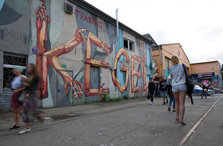
## Description RAW-Gelände is one of Berlin’s most vivid examples of how the city has repurposed industrial space into a living cultural district. Located in Friedrichshain, the complex is known for its raw, creative atmosphere, street art, nightlife, event spaces, and independent venues. It does not feel polished in the conventional tourist sense, and that is exactly why people seek it out. The attraction is not a single building or museum hall; it is an urban environment shaped by layers of reuse, subculture, and creative experimentation. Historically, the area served railway and industrial functions, and that past still shapes the look and feel of the site. The result is a place of walls, courtyards, metal structures, graffiti, and open space where culture often feels more improvised than formal. One little-known aspect of RAW-Gelände is that it continues to function as a flexible venue ecosystem rather than a fixed monument. That means the experience can change depending on the day of the week, the season, and what events are running at the time. This fluid character is part of its appeal. Visitors often come for different reasons. Some want nightlife and live music, others come for photography, skating, street art, flea-market browsing, or simply to experience a side of Berlin that feels less curated than the central museum districts. The area reflects a very Berlin idea: the city’s strongest attractions are not always polished icons, but places where people still make, modify, and repurpose space in real time. RAW-Gelände captures that spirit extremely well. What makes it particularly interesting for travelers is the contrast between its industrial shell and its social energy. During the day, some sections feel like an open-air cultural playground. At night, certain venues transform the area into a magnet for music and late-night crowds. Because of that, RAW-Gelände is less about a single checklist moment and more about atmosphere. It is the kind of place where the details matter: the walls, the posters, the music drifting from a doorway, and the sense that the district is still being written by the people using it. ## Location RAW-Gelände is in Berlin, Germany, in the Friedrichshain district near the Warschauer Straße area. That puts it in one of the city’s liveliest neighborhoods, with easy access to public transportation, bars, clubs, and other urban attractions. The easiest way to get there is by U-Bahn, S-Bahn, tram, or taxi to the Warschauer Straße area, then continue on foot. Because the site is embedded in a busy neighborhood, walking the final stretch is usually the best way to understand where you are going and to notice the surrounding street life. If you are already exploring East Berlin, RAW-Gelände fits naturally into a larger route that includes the East Side Gallery, riverfront walking paths, and nightlife around Friedrichshain and Kreuzberg. Visitors should remember that the area is not a single enclosed attraction with one gate and one route. It is a district-like complex, so a little flexibility helps. Some parts may be busier or more active than others depending on the time of day. ## Tips Check ahead for events, especially if you want live music, markets, or club nights, because the site’s appeal changes a lot with programming. Wear practical shoes. The ground can be uneven in places, and the atmosphere is more industrial than manicured. That roughness is part of the visual character. If you are sensitive to noise or crowds, visit earlier in the day. If you want the energetic side of the area, go later and be prepared for a more intense urban environment. Take time to look beyond the obvious venues. The graffiti, passageways, posters, and improvised corners are often as interesting as the headline bars or clubs. RAW-Gelände rewards curiosity and is best approached as a walkable culture zone rather than a conventional sightseeing stop. ## Conclusion RAW-Gelände is a distinctly Berlin attraction shaped by industrial history, street culture, and constant reinvention. It is ideal for travelers who want a gritty, creative, and flexible urban experience rather than a traditional monument. ## FAQ **What is RAW-Gelände?** It is a former railway and industrial site in Berlin that now hosts cultural spaces, nightlife, art, and events. **Is it open all day?** Different parts operate on different schedules, so it is best to check individual venues and event listings. **Is it family-friendly?** Some daytime areas can be, but the overall atmosphere varies and may be more suitable for older visitors depending on the time and event. **What is it best for?** Street art, alternative nightlife, urban photography, and experiencing Berlin’s creative edge. **How much time should I plan?** At least one to two hours for a casual visit, more if you are attending an event or planning to eat and explore nearby areas. ## Links - [Official Website](https://raw-gelaende.de/) - [Berlin tourism information](https://www.visitberlin.de/en)
GemVoyage Team • World
Berlin
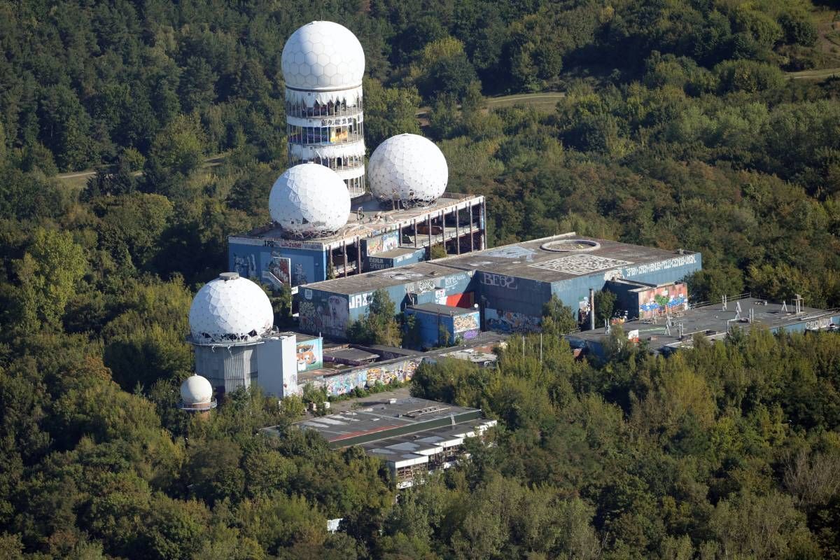
## Description Teufelsberg is one of Berlin's most unusual landmarks, combining Cold War history, postwar rubble, urban exploration energy, and large-scale street art. The hill itself was built from debris after World War II, which already makes it unusual in a city with so much layered history. On top of that artificial landscape stand the remains of an abandoned listening station that once played a role in intelligence monitoring during the Cold War. Today, the site has evolved into a destination for visitors who want a mix of history, raw architecture, and an atmosphere that feels unlike anything else in central Berlin. The site is especially appealing to people who enjoy places that are part ruin, part gallery, and part lookout point. The decaying domes and walls are covered with murals and tags that turn the space into a constantly changing outdoor canvas. A little-known fact is that Teufelsberg sits on what was once intended to be a Nazi military college, but the project never reached completion and the site eventually became part of Berlin's postwar transformation. That layered past gives the hill a strange and powerful presence. ## Location Teufelsberg is in the western part of Berlin, Germany, near the Grunewald forest. It is outside the dense historic center but still accessible by public transport followed by a short walk or bus ride. Because the hill is elevated and somewhat isolated within a wooded area, the journey feels more like leaving the city than simply crossing neighborhoods. That is part of its appeal. The most practical way to get there is by transit and walking, especially if you want to avoid parking concerns and enjoy the forest approach. Visitors should check opening times before going, since access can vary by season and event schedule. The site is best treated as a half-day trip rather than a quick stop. ## Tips - Wear sturdy shoes, because parts of the site are uneven and more rugged than a standard museum visit. - Bring cash or a payment method accepted on-site in case access fees or special exhibits apply. - If you like photography, go when the weather is clear so the skyline and street art stand out more sharply. - Plan for a combination of outdoor exposure and indoor-like enclosure, since the structures can feel windy and exposed. - Leave time to explore the surrounding forest paths if you enjoy a longer, more atmospheric visit. - Check ahead for guided tours or event days, since they can add context to the Cold War history. ## Conclusion Teufelsberg is a reminder that Berlin often turns difficult history into something creative and publicly accessible. The result is a place that feels rough, memorable, and deeply distinctive, especially for travelers who want more than postcard landmarks. ## FAQ ### Is Teufelsberg safe to visit? Yes, it is generally safe during normal visiting hours and in managed public areas. Because the terrain is uneven and partly ruined, visitors should stay alert and follow site rules. The main risk is usually physical footing rather than anything related to the site's history. ### Do you need a guided tour? You do not always need one, but a guided tour can make the experience much richer. The site has layers of history that are easy to miss if you only walk around on your own. If you are interested in espionage, architecture, or Berlin history, a tour is often worthwhile. ### How long should I spend there? One to two hours is enough for a basic visit, but art and history fans may stay longer. If you also want to walk in the forest or take photos from different viewpoints, plan for more time so the visit does not feel cramped. ### Is it good for photography? Yes, it is one of Berlin's more photogenic places because the ruins, murals, and views combine well. Overcast days can work nicely for moody shots, while clear days are best for skyline photographs. Either way, the textures are strong and visually rewarding. ### Why is Teufelsberg famous? It is famous because it combines a Cold War listening station, a man-made hill created from rubble, and a vivid street art scene. Few places in Berlin bring those three elements together so effectively, which is why it stands out among the city's more conventional attractions. ## Links - [Official website](https://teufelsberg-berlin.de/) - [Wikipedia](https://en.wikipedia.org/wiki/Teufelsberg)
GemVoyage Team • World

Comments