Discover extraordinary places shared by our community of travelers
Seoul
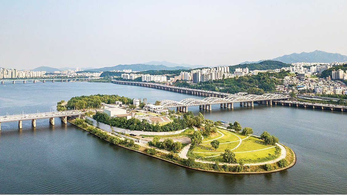
## Description Nodeul Island is a compact cultural complex on the Han River offering performance spaces, green areas, and a music-focused programming lineup. More than just a riverside park, Nodeul is a deliberate cultural experiment: its architecture and programming weave public space, live performance, and small-scale festivals into a compact, walkable site. The island hosts live concerts ranging from acoustic singer-songwriters to electronic sets, pop-up book fairs, artist talks, workshops, and rotating markets. Its landscaped terraces and shaded lawns are deliberately designed to encourage lingering, informal performances, and community gatherings. Nodeul has become known for spotlighting emerging Korean musicians and experimental performers alongside established acts, making it an attractive place for music lovers who want to catch fresh talent in an intimate setting. The island’s mix of architecture, open-air stages, and sheltered rooms means events happen year-round—outdoor stages run during warmer months while smaller indoor spaces host talks and exhibitions in cooler seasons. For photographers and writers looking for evocative urban scenes, Nodeul’s riverside vistas, evening concert lighting, and the soft hum of Seoul traffic across the water make for compelling subjects. The island also supports small food vendors and seasonal stalls that bring a local flavor to the cultural programming. From a practical standpoint, Nodeul is a model for how urban design can activate a riverside edge: pedestrian bridges and plazas, varied seating, and clear sightlines to performance areas keep programming accessible and family-friendly. The island’s public calendar is updated frequently, and local arts organizations often collaborate with the site to pilot new formats—outdoor listening sessions, experimental pop-up shows, and community workshops are common. Whether you’re planning an evening concert or a daytime literature event, Nodeul’s programming rewards repeat visits: familiar artists return, and new creative experiments appear each season. ## Location Nodeul Island sits on the Han River close to the Noryangjin and Yeouido areas of Seoul, reachable by subway and a short walk across a well-maintained pedestrian bridge from the south bank. The nearest major subway stops provide easy access for visitors staying anywhere in central Seoul, and the island’s signage in English and Korean helps international visitors orient themselves quickly. Because the island sits on the river, walking routes from nearby neighborhoods are scenic and often used by locals for jogging and evening strolls. ## Tips - Check the events calendar ahead of time: Nodeul’s draw is its programming, and many of the best concerts and markets are pre-announced online. Booking tickets in advance for popular shows avoids disappointment. - Arrive early for evening concerts to claim good riverside seating; bring a small blanket or foldable chair if you prefer more comfortable seating on the grass. - Visit at sunset for the best photo opportunities: the interplay of river light, concert lights, and Seoul’s skyline creates a memorable atmosphere. - Pack layers—a light jacket is wise for open-air evening events when the river breeze picks up, even in summer. - Explore the island’s perimeter paths before events; quiet spots and viewpoints are often less crowded than main plazas. - Support local vendors: seasonal food stalls and nearby cafés help sustain small operators who participate in Nodeul’s pop-up markets. - If you’re interested in emerging music, follow local promoters and Nodeul’s newsletter for surprise showcases and free programs. ## Conclusion Nodeul Island is a compact cultural destination that combines live music, community programming, and riverside relaxation in Seoul. It succeeds as a place where design, sound, and community converge—ideal for travelers who want to experience contemporary Korean culture beyond mainstream tourist stops. With a packed calendar, accessible layout, and an emphasis on new voices in music and the arts, Nodeul rewards curious visitors and repeat explorers alike. ## FAQ Q: Is there an admission fee? A: Many daytime activities and free concerts are available without charge, while larger evening shows or special events may require purchased tickets—check the event listing. Q: How do I get there by public transport? A: Use the nearest subway stations (check local maps), then follow pedestrian signage to the river bridge that leads to Nodeul; buses and taxis also serve the area. Q: Are events kid-friendly? A: Yes—many daytime workshops and family-oriented performances are suitable for children, though some late-night concerts may be more adult-focused. Q: Can I bring food and drink? A: Outside food and non- alcoholic drinks are generally allowed; licensed vendors operate during larger events—always check event-specific rules. Q: Is the island wheelchair accessible? A: The site offers accessible paths and ramps, but some elevated terraces may have limited access—consult the venue map for specific event locations. ## Links - [Seoul Travel Guide](https://www.visitseoul.net/)
GemVoyage Team • World
Rome
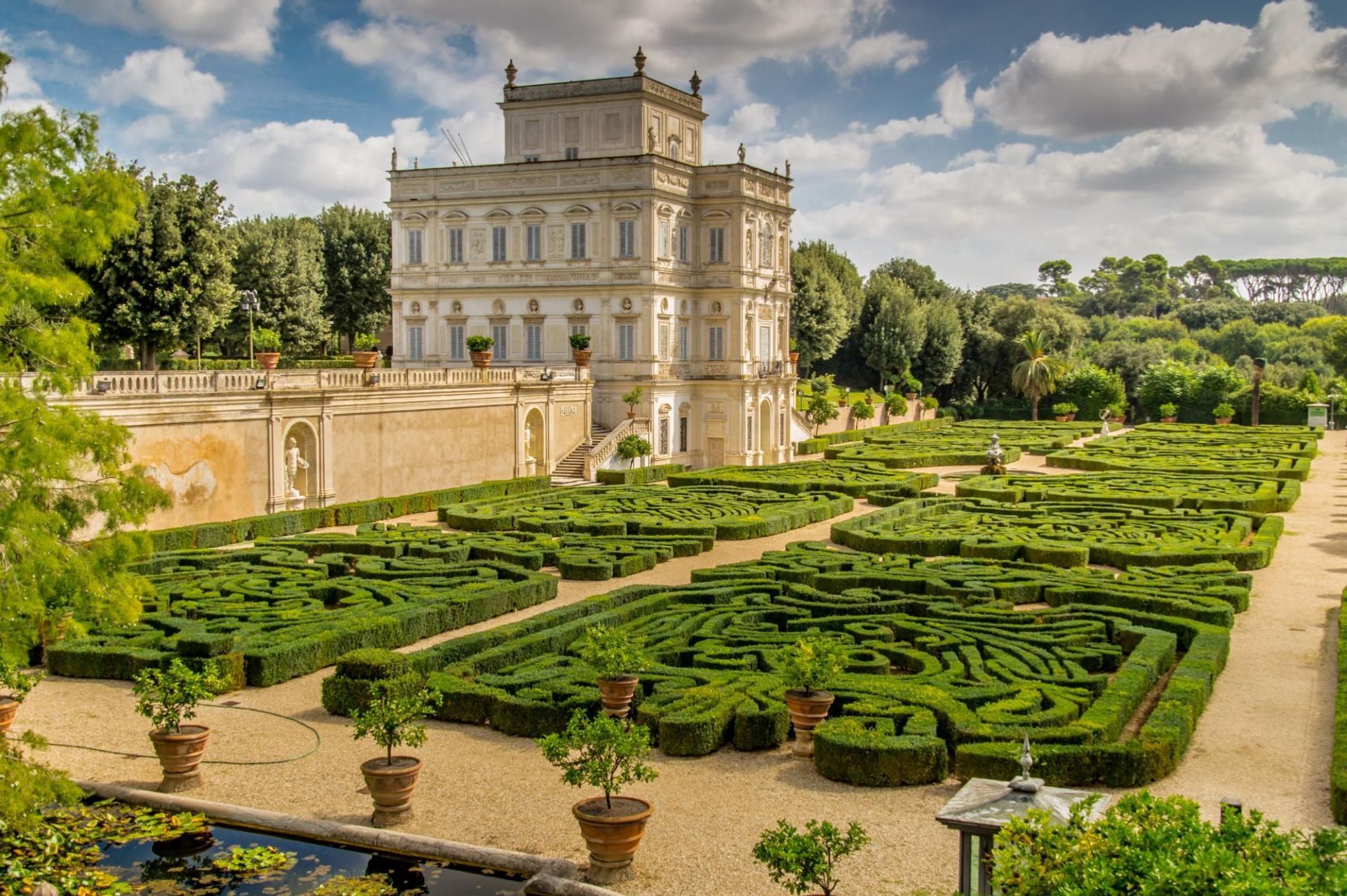
## Description Villa Doria Pamphili is Rome’s largest landscaped villa park, a sprawling green refuge that stretches across rolling lawns, tree-lined avenues, and layered gardens. The park is a living palimpsest: its design reflects generations of development, blending formal Italianate fragments with later Romantic landscape interventions. Visitors discover broad promenades shaded by mature pines and cypresses, intimate groves, terraced viewpoints, ornamental fountains, and the occasional historic villa or chapel tucked into the greenery. What separates Villa Doria Pamphili from Rome’s better-known manicured gardens is its scale and everyday use: runners training along long straight avenues, families picnicking under broad trees, and musicians gathering informally on sunny afternoons. The park hosts seasonal cultural programs—outdoor concerts, film nights, and neighborhood festivals—yet retains a quiet dignity even during busier times. Its pathways offer both restful, shaded routes and open, sunlit clearings; photographers and nature lovers will appreciate the changing light through the trees and occasional glimpses of Roman rooftops beyond. The park’s history is visible in its layered landscaping: landscaped terraces that once anchored a noble estate, interspersed with woodland patches that feel older and wilder. For those studying garden history, the site provides a satisfying case study of how aristocratic pleasure grounds transitioned to public urban parks. For ordinary visitors, the pleasures are simpler—ample space, restful atmosphere, and a sense of escape from Rome’s denser historic core. ## Location Villa Doria Pamphili occupies a large swathe in western Rome, bordering neighborhoods like Monteverde and Trastevere. It is reachable by bus, taxi, and on foot from several tram and metro stops; the park’s size means different entrances suit different itineraries, so checking a map before you go helps you plan whether to approach from the north, south, or west side. ## Tips - Wear comfortable footwear: the park’s size rewards long walks and exploration across varied surfaces. - Visit on a weekday morning for the quietest experience; weekends attract many local families and picnickers. - Bring a picnic and a blanket—there are many scenic clearings suited to lingering. - Rent a bike or bring a folding bike if you want to cover more ground; some routes are well-suited to casual cycling. - Keep an eye on the events board: the park occasionally stages open-air concerts and screenings, which can be a delightful, low-cost cultural night out. - Respect local rules about barbecues and alcohol: these can be restricted in parts of the park. ## Conclusion Villa Doria Pamphili is an expansive urban refuge offering both active recreation and relaxed contemplation. Its layered history, varied landscapes, and everyday uses make it a revealing place to spend a few hours or an entire afternoon—particularly appealing for travelers seeking outdoor green spaces and a more local side of Rome. ## FAQ Q: Is there an entrance fee? A: No—the park is public and free to enter, which makes it a popular local destination for recreation and relaxation. Q: Are dogs allowed? A: Dogs are usually permitted on-leash in most areas; check local signage for any leash-free zones or restrictions. Q: Can I cycle through the park? A: Yes—many paths are bike-friendly, though some narrower or pedestrian-priority areas may be more suitable for walking. Q: Are there public restrooms and water fountains? A: Basic facilities are available but can be limited; carry some water and check maps for restroom locations during longer visits. Q: Are there guided tours of the park’s history? A: Occasionally local associations offer guided walks focusing on the villa’s history and gardens—look for community announcements or contact local tourism offices. ## Links - [Villa Doria Pamphili (Wikipedia)](https://en.wikipedia.org/wiki/Villa_Doria_Pamphili)
GemVoyage Team • World

Seoul
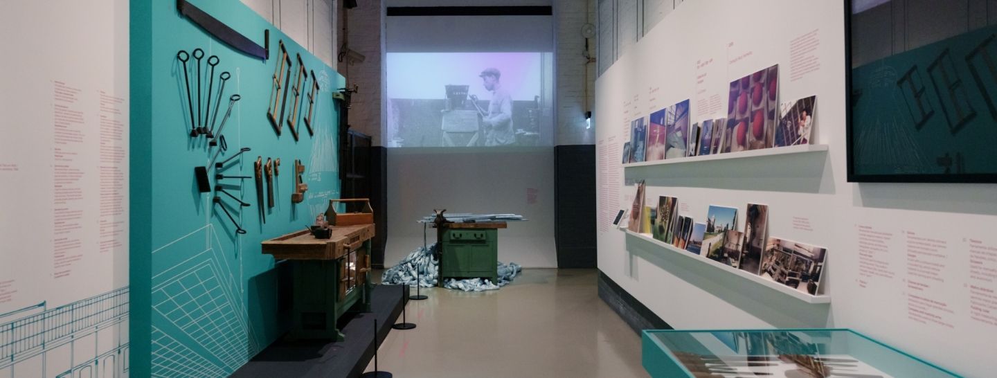
## Description Oil Tank Culture Park is an inventive urban redevelopment project that transforms obsolete oil storage tanks near Hapjeong into a layered cultural complex. The site is notable for its adaptive reuse approach: industrial silos and tanks were structurally preserved and repurposed as galleries, performance spaces, and community areas. The result is a tactile mix of heavy industrial surfaces and light-filled cultural rooms—an atmospheric contrast that frequently features in discussions about sustainable urban design and creative placemaking. Programming at the Oil Tank Culture Park combines curated exhibitions with community-driven activities. The large circular tanks are used for immersive installations and concerts; smaller adjacent spaces host workshops, film screenings, and local markets. The park’s outdoor terraces and green roofs provide vantage points for both the site itself and views across nearby neighborhoods, creating a sequence of experiences that shift between enclosed, resonant tanks and open, landscaped terraces. For visitors interested in architecture, industrial heritage, or contemporary culture, the site offers multiple points of fascination. Preservation choices—retaining the tanks’ raw metal texture, exposing concrete rings, and inserting slender circulation elements—make the site legible as both a former industrial hub and a cultural incubator. The park’s programming often foregrounds sustainability themes, community participation, and experimental performance formats. ## Location The Oil Tank Culture Park is located in Mapo-gu, Seoul, close to Hapjeong station and within walking distance of the World Cup Stadium area. It is well served by subway lines and local buses, and its signage makes it straightforward for international visitors to find. The park is frequently combined in itineraries with nearby Hongdae’s nightlife and Mangwon’s markets. ## Tips - Check the cultural calendar before visiting—special exhibitions and ticketed concerts are common and may require advance booking. - Wear comfortable shoes and expect varying surfaces: pathways range from concrete tank platforms to landscaped terraces. - Bring a light layer for rooftop areas and evening events—the wind can be brisk on exposed terraces. - Combine a visit with nearby Hongdae for dinner or an evening out; the area offers many small restaurants and cafés. - Respect installation boundaries and photography rules within exhibition spaces—some shows restrict flash or tripod use. ## Conclusion Oil Tank Culture Park is a striking example of how industrial heritage can be repurposed into vibrant public culture. It rewards visitors with a mix of dramatic industrial architecture, innovative programming, and a neighborhood-friendly atmosphere—ideal for architecture enthusiasts, cultural explorers, and people who enjoy offbeat urban sites. ## FAQ Q: Are events free? A: Some events and exhibitions are free to the public; larger performances, immersive shows, and special exhibitions may require tickets—check each event’s listing. Q: Is the site wheelchair accessible? A: The park includes ramps and accessible routes, though some older industrial areas may present challenges—contact the venue for detailed accessibility maps. Q: Can I photograph the tanks and installations? A: General photography is usually allowed in public spaces, but specific exhibitions may restrict photography—always check signage or ask staff. Q: Are there food and drink options on-site? A: Occasional pop-up vendors and nearby cafés supply food and drink during events; full-service restaurants are more common in surrounding neighborhoods. Q: Is there parking? A: On-site parking is limited; public transport is the recommended way to visit. ## Links - [Oil Tank Culture Park](https://www.theseoulguide.com/oil-tank-culture-park/)
GemVoyage Team • World
Lisbon
## Description MAAT (Museum of Art, Architecture and Technology) is a contemporary cultural center on Lisbon’s Belém waterfront with a bold, sculptural building and a program that explores intersections of art, architecture, and digital culture. The museum’s sinuous façade and rooftop promenade make it immediately recognizable in Lisbon’s riverside panorama, while its galleries host rotating exhibitions, commissions, and conferences that emphasize contemporary art practices. Inside, MAAT presents a mix of international and local artists, with a particular interest in projects that engage new media, digital art, and design. The museum’s programming frequently includes public talks, workshops for families, and collaborations with design festivals—evidence of its ambition to operate as a civic platform rather than a static collection. The building’s rooftop terrace is itself a public amenity, offering panoramic views across the Tagus River and serving as a flexible event space for outdoor performances and gatherings. MAAT’s curatorial approach is often experimental, pairing architectural interventions with media installations and time-based works that reward repeat visits. For visitors, this means each visit can feel different: sometimes the highlight is a single striking installation, other times the rooftop programming and view become the defining memory. The museum’s thoughtfully designed visitor flow and bilingual signage make it accessible to tourists and locals alike. ## Location MAAT is located in Belém, west of Lisbon’s historic center, adjacent to the Belém Cultural Center and near landmarks like Jerónimos Monastery and the Belém Tower. Public transport options include tram 15, buses, and taxis; it’s also a pleasant walk from other Belém attractions if you have the time. ## Tips - Book timed-entry tickets for busy exhibition periods to avoid queues, especially on weekends and during tourist high season. - Visit the rooftop terrace close to sunset for beautiful views of the Tagus and soft evening light for photography. - Check MAAT’s event calendar for family workshops and talks that may align with your travel dates. - Pair a visit with nearby sites—Jerónimos Monastery, Belém Tower, and the pastry shops known for pastéis de nata. ## Conclusion MAAT is a dynamic cultural destination that combines striking architecture, a thoughtful contemporary program, and public-facing amenities. It’s an essential stop for visitors interested in contemporary art and design, and its riverside setting makes it easy to fold into a broader day in Belém. ## FAQ Q: Are there timed tickets? A: Yes—popular exhibitions may require timed-entry tickets; book online to secure preferred slots and avoid long waits. Q: Is MAAT family-friendly? A: Definitely—MAAT offers family workshops and programs designed to engage younger visitors, though some installations may have age recommendations. Q: Are English guides available? A: Many exhibitions and staff resources are available in English; check the information desk for guide options or multilingual materials. Q: Can I visit the rooftop without entering the galleries? A: Policies vary—sometimes rooftop access is included with general admission, while special events may require a separate ticket; check the museum’s website. Q: Is photography allowed inside? A: Non-flash photography is generally allowed in public galleries, but some works and special exhibitions may prohibit photography—obey posted restrictions. ## Links - [MAAT (official)](https://www.maat.pt)
GemVoyage Team • World
Arizona
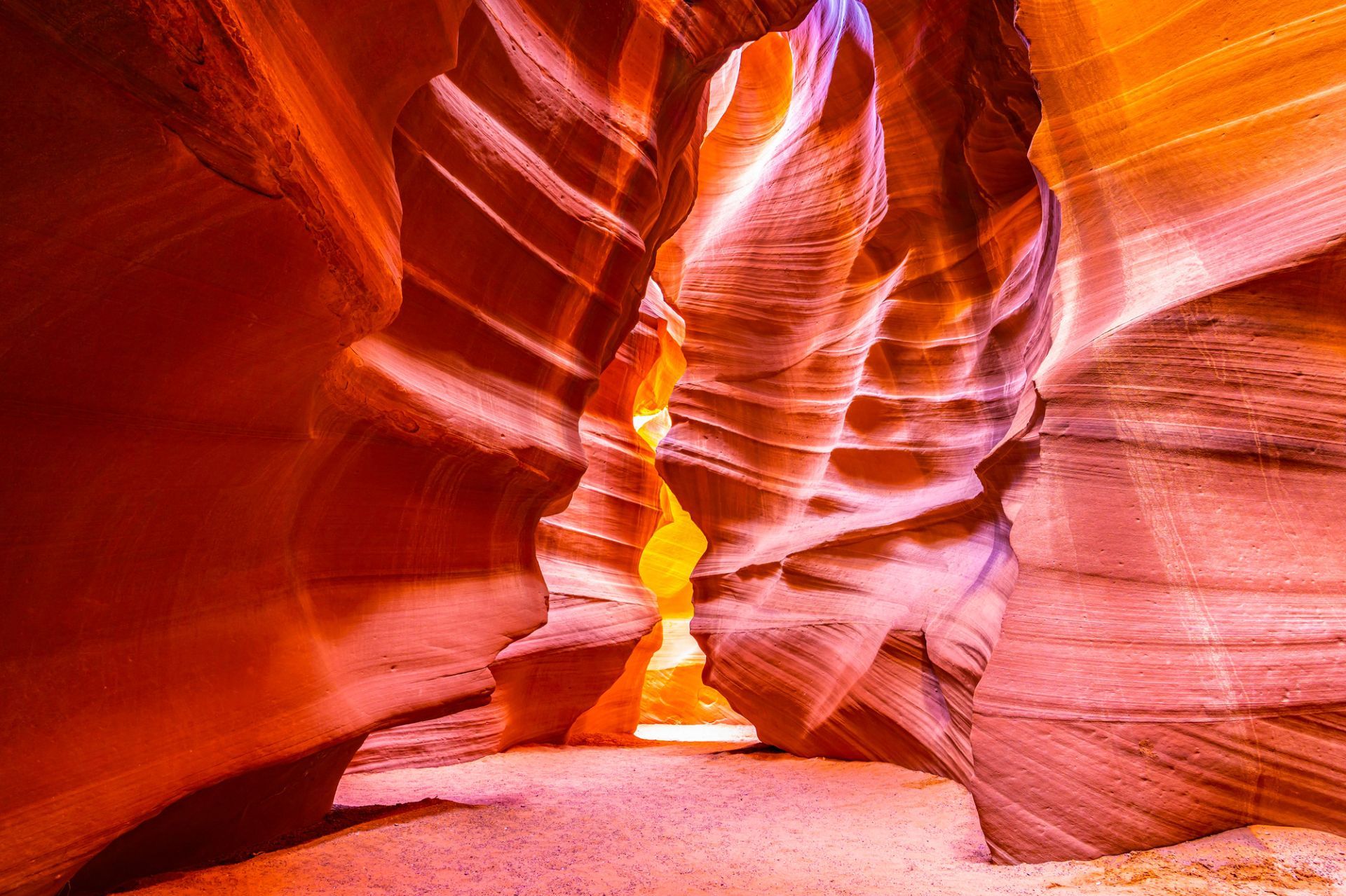
## Description Antelope Canyon, on Navajo land near Page, Arizona, is a set of narrow slot canyons carved into Navajo Sandstone by millennia of water and wind erosion. The result is a sequence of sinuous, polished walls that twist into narrow passages, channeling shafts of light into warm, copper-toned swirls that photographers prize. There are two main sections commonly visited: Upper Antelope Canyon (more iconic for vertical light beams in summer) and Lower Antelope Canyon (a more maze-like walk that requires climbing). The interplay of light, shadow and texture transforms the canyon’s interior into a living sculpture that changes with the sun’s angle. Antelope Canyon’s combination of geological finesse and cultural sensitivity makes it unique: it’s on Navajo Nation land and visits occur under Navajo guides who share cultural context and ensure conservation. The ephemeral quality of light in the canyon is the main draw, and every visit offers a subtly different visual story depending on time of day and season. Visiting Antelope Canyon is an intimate, often crowded experience that rewards patience and close observation. The sculpted walls are tactile and close, and the sense of enclosure makes small variations in light and dust dramatically affect composition. Guides routinely manage group flows and timing to optimize safety and photographic opportunity, and many operators now offer specialized photo tours that allow extra time or more flexible tripod policies. Safety is a constant priority — because slot canyons channel water, flash floods are a real hazard and tours may be altered or canceled in the face of storm risk. Respect for Navajo cultural protocols is also essential: guides often include stories and historical context that enrich a visit and reinforce why access is managed. Beyond the two main canyons, nearby attractions around Page — Horseshoe Bend, Lake Powell and Glen Canyon National Recreation Area — make the area a compact cluster of dramatic southwestern landscapes. Combining these sites into a short itinerary can balance the compressed, processed light of the slot canyons with broad, open panoramas of the Colorado River and surrounding desert. ## Location Antelope Canyon lies near Page, Arizona, in the southwestern United States on Navajo Nation land. The canyons are accessed by guided tours departing from Page; bookings are required, and many operators combine Antelope Canyon with nearby attractions like Horseshoe Bend and Lake Powell. Most tours meet in Page; travel to the canyon involves a short drive and, in some cases, a brief ride across Navajo lands to the canyon entrance. Tour operators coordinate closely with park officials and Navajo authorities; book in advance during peak seasons and confirm pickup details. Page has several accommodation options, from campgrounds to hotels, and is a good base for multi-day exploration of the region. ## Tips - **Book Navajo-guided tours:** Access to both Upper and Lower Antelope Canyons is restricted to authorized Navajo guides — book through reputable operators and respect cultural protocols. - **Time your visit for light:** For the classic light beams in Upper Antelope Canyon, mid-day in summer is preferred; other seasons offer softer, diffused light. - **Bring a tripod if allowed:** Some tours permit tripods (often in photo-specific sessions); check operator policies before arrival. - **Be mindful of flash floods:** Slot canyons can be hazardous during heavy rain; guides monitor weather and may cancel tours if flash flood risk exists. - **Protect your gear from sand:** The environment is dusty; use camera covers and clean gear after visits. - **Choose the right tour type:** Standard interpretive tours offer context and safety; photo tours are slower and often allow tripods but require advance booking. - **Expect narrow passages:** Lower Antelope requires more physical movement; wear comfortable clothes and be prepared to climb short ladders or squeeze through tight sections. - **Respect cultural guidance:** Photography of certain features or during ceremonies may be restricted — follow your guide's direction. - **Combine sites for variety:** Pair canyon visits with sunrise at Horseshoe Bend or a boat trip on Lake Powell to round out your visual narrative. ## Conclusion Antelope Canyon is a masterpiece of erosion and light — a place where sandstone artistry and cultural stewardship intersect to create intense photographic and contemplative experiences. Guided visits make it accessible while honoring its Navajo custodianship. Approach Antelope Canyon with curiosity and respect, and you’ll come away with a visceral appreciation for how water, time and human stewardship intersect. For photographers, the canyon is a study in subtle gradients and form; for travelers, it’s an opportunity to learn about the cultural landscape of the Navajo Nation while witnessing an extraordinary geological gallery. ## FAQ - **Q: Which is better, Upper or Lower Antelope Canyon?** - A: Upper is famed for light beams and is more accessible with level walks; Lower is narrower with ladders and a more adventurous feel. - **Q: Do I need a reservation?** - A: Yes — tours sell out, especially in peak season; book in advance. - **Q: Is Antelope Canyon wheelchair accessible?** - A: Accessibility varies: Upper has relatively easier access but still includes uneven surfaces; check specific operator accommodations. - **Q: Can I fly a drone near Antelope Canyon?** - A: Drone use is generally restricted in Navajo lands and near protected sites; check local rules and obtain permission where applicable. - **Q: What are the best months for photography?** - A: Summer delivers the strongest vertical beams around midday; spring and autumn provide softer light and cooler conditions, which many photographers prefer. - **Q: How long does a typical tour last?** - A: Standard canyon tours range from 45 minutes to 1.5 hours including access and return; photo tours may be longer. - **Q: Are there restrictions on clothing or equipment?** - A: Wear closed-toe shoes for lower canyon sections, protect gear from sand, and follow guide instructions for tripods or flash use. ## Links - [Antelope Canyon — Wikipedia](https://en.wikipedia.org/wiki/Antelope_Canyon) - [Navajo Nation Parks & Recreation](https://www.navajonationparks.org)
GemVoyage Team • World
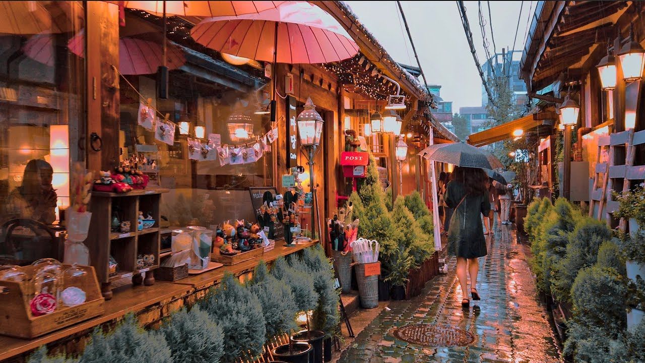
Seoul
## Description Ikseon-dong Hanok Village is a compact, walkable district of restored traditional Korean houses (hanok) that has quietly become one of Seoul’s most charming destinations for visitors who prefer intimate, offbeat experiences. Narrow alleys thread between low-slung wooden eaves and tiled roofs, leading to a concentration of independently run cafes, craft shops, design ateliers, small restaurants, and boutique guesthouses. What makes Ikseon-dong compelling is its layered character: from a distance it reads as preserved tradition, but up close you’ll find contemporary interiors, modern light fixtures, and bold small-business design that sits harmoniously within historic exteriors. Many of the hanok are careful restorations completed in the last decade, which means you get the visual poetry of old Seoul with the conveniences and comforts of modern hospitality. The neighborhood is an excellent example of sensitive urban revitalization—locals and entrepreneurs have repurposed former residential clusters into a dense network of micro-businesses that reward slow exploration. Ikseon-dong’s scale is part of its appeal: where larger hanok districts can feel staged or touristy, here the alleys are intimate and discoveries are often serendipitous—an influential ceramicist around the corner, a tiny cocktail bar behind a lacquered doorway, a handcrafted stationery shop tucked beneath an old roof. ## Location Ikseon-dong sits in Jongno-gu in central Seoul, a short walk from Jongno 3-ga station and easily combined with visits to nearby cultural anchors like Changdeokgung Palace and Insadong. For many travelers, Ikseon-dong makes a great half-day detour from the palace circuit: it’s compact enough to be explored on foot and centrally located so you can move quickly between historic sites, galleries, and dining options. ## Tips - Explore deliberately: walk slowly, follow side alleys, and allow time to peek into courtyards and small doorways—some of the best cafes and shops are not visible from main lanes. - Try specialty menus: many cafes in Ikseon-dong focus on single-origin coffee, artisanal teas, or themed tasting menus—ask staff for recommendations and seasonal specials. - Respect residents: while the area is visitor-friendly, many hanok still function as private homes or small businesses; be mindful when photographing doorways and courtyards. - Visit at different times: morning light highlights wooden details and offers quieter streets, whereas evenings bring lantern-lit alleys and a more atmospheric café-and-bar scene. - Accessibility note: alleys can be narrow with occasional steps; check individual venues for wheelchair access before visiting. ## Conclusion Ikseon-dong is a delightful micro-neighborhood that reimagines traditional architecture for modern urban culture. It’s ideal for café-hopping, thoughtful shopping, photography, and discovering small-scale craftsmanship. The district rewards curiosity: the more time you give it, the more layered the experience becomes—historic textures, contemporary comforts, and a localized creative energy that feels authentically Seoul. ## FAQ Q: Is Ikseon-dong very touristy? A: It has grown in popularity but remains smaller and more intimate than other hanok districts like Bukchon; mornings are generally quieter. Q: Are there places to stay in Ikseon-dong? A: Yes, a handful of boutique hanok guesthouses and small guest accommodations offer overnight stays—book early for weekends. Q: What’s the best time of day to visit? A: Early morning for quiet exploration and late afternoon into evening for lantern-lit ambiance and café culture. Q: Is it wheelchair accessible? A: The historic alleys have uneven paving and steps in places—accessibility varies by venue; call ahead for specific locations. Q: Can I take photos freely? A: Public areas are fine for photography, but be respectful in private courtyards and ask permission before photographing people or inside shops. ## Links - [Korean Travel Guide](https://english.visitkorea.or.kr)
GemVoyage Team • World
Rome
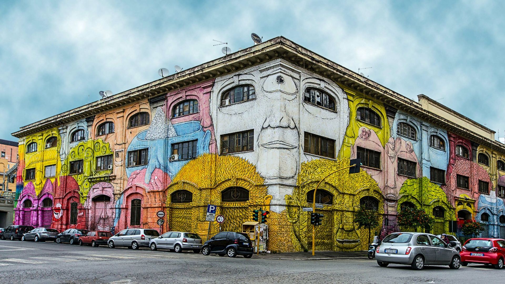
## Description Ostiense in Rome is a neighborhood that quietly combines industrial history, creative reinvention, and a growing street-art scene. Long overlooked in favor of the city’s classical core, Ostiense has become a canvas for large-scale murals, community art projects, and cultural venues that repurpose former warehouses and factories. The area’s atmosphere is energetic and contemporary—the kind of place where gritty, working-class textures meet curated cafes, design-driven restaurants, and cultural centers. One lesser-known detail: many of the murals and public artworks here are the result of organized collaborations between international and Italian artists, local associations, and municipal regeneration programs, meaning the pieces often reflect a distinct local voice rather than random tagging. Ostiense is also notable for nearby cultural institutions such as Centrale Montemartini—an arresting museum that juxtaposes classical sculpture with industrial architecture—as well as evolving food halls and waterfront promenades that add to the neighborhood’s appeal. The daily rhythm here is different from Rome’s historic center: it’s more local, less hurried, and often the setting for pop-up markets, gallery openings, and late-night dining. ## Location Ostiense lies south of Rome’s historic center, adjacent to Stazione Ostiense and the Gasometro area. The neighborhood is easily reachable by metro (Piramide station on Line B), regional trains, and buses, making it convenient for travelers who want to pair a visit with nearby attractions or evening dining options. ## Tips - Walk the streets deliberately and allow time for visual discoveries—large murals and hidden installations are often tucked down industrial lanes. - Consider a guided street-art tour to gain context on the murals, the artists, and the local regeneration efforts that funded them. - Combine visits with cultural stops: Centrale Montemartini, the former Gasometro, and nearby food markets offer a rounded itinerary. - Respect private property and photograph from public sidewalks—some murals occupy private building facades. - Best times: weekday afternoons for quieter explorations, and early evenings for the dining scene; weekends may have markets and events. ## Conclusion Ostiense offers a living gallery of contemporary street art woven into an urban tapestry of industrial heritage and modern cultural life. For travelers who appreciate street art, creative urban renewal, and a less-touristed side of Rome, Ostiense is a rewarding stop that captures both local momentum and adventurous city-making. ## FAQ Q: Are Ostiense’s murals permanent? A: Many are long-term projects, but street art can be transient—check local galleries or tour operators for the most current highlights. Q: Are guided street-art tours available? A: Yes; several local guides and cultural organizations run walking tours that explain the art, artists, and history behind the works. Q: Is Ostiense safe to visit at night? A: Generally yes—areas around the train station and main streets are lively at night, though standard urban caution is advised in quieter lanes. Q: Can I photograph the murals? A: Absolutely; murals in public spaces are typically fine to photograph—avoid obstructing traffic or private entrances while shooting. Q: What else is nearby to pair with an Ostiense visit? A: Centrale Montemartini, food halls, and the riverside promenade are excellent nearby additions. ## Links - [Ostiense](https://www.partir-a-rome.com/quartiers-rome/ostiense-tor-marancia)
GemVoyage Team • World
Rome
## Description Pigneto is a bohemian quarter on the eastern edge of Rome's historic center that has emerged as a center for alternative culture, independent cafés, music venues, and street art. Historically a working-class neighborhood, Pigneto's present-day energy combines laid-back local life with a creative fringe: intimate live-music bars, experimental restaurants, and murals that reward aimless wandering. Film scholars and cultural tourists sometimes note Pigneto's connection to Italian neorealist cinema—streets and squares there still convey a lived-in authenticity that feels less curated than tourist-focused central neighborhoods. What makes Pigneto appealing to travelers is the neighborhood's layered, discoverable quality: new cafés sit beside traditional trattorie, and small galleries share corners with vinyl shops. The street art is dispersed rather than concentrated, so walking (or taking a short local bus) remains the best way to discover murals, installations, and community projects. Search-friendly phrases include "Pigneto Rome street art", "Pigneto nightlife guide", and "alternative Rome neighborhoods"—queries that pair well with local blog posts and neighborhood guides. ## Location Pigneto lies east of Rome's center, convenient to Termini Station and the San Lorenzo district. The neighborhood is served by Line C (Pigneto station) and several local buses; it's a short taxi ride from central hubs. Because Pigneto is largely compact, most visitors explore on foot, moving between squares, cafes, and parklets that form the neighborhood's social hubs. ## Tips - Walk slowly and explore side streets: many of the district's best murals and hidden bars are off main roads. - Try aperitivo: early-evening aperitivo culture is vibrant—enjoy a pre-dinner drink alongside small plates at neighborhood bars. - Visit for live music nights: several small venues host jazz, indie, and experimental music on specific nights—check venue pages for schedules. - Respect local life: Pigneto has an active residential community—keep noise reasonable late at night and support neighborhood businesses. - Bring cash for smaller venues: while many places accept cards, some bars and small galleries operate cash-only. ## Conclusion Pigneto is a compelling stop for travelers who prefer neighborhood immersion to classic sightseeing. Its street art, convivial bars, and creative energy reward the curious explorer: you can spend an evening hopping intimate venues, or a whole day documenting murals and sampling modern Roman casual dining. ## FAQ Q: Is Pigneto safe for solo travelers? A: Generally yes—Pigneto is popular with locals and visitors alike; normal urban precautions apply, especially late at night. Q: When is the best time to visit for nightlife? A: Evenings from Thursday to Saturday are lively; midweek nights may have smaller shows and quieter streets. Q: Can I find guided street-art walks? A: Yes—local guides and small walking tours occasionally operate in Pigneto; independent bloggers and tour platforms often list scheduled walks. Q: Are there good places to eat for food restrictions? A: Pigneto has a variety of eateries including vegetarian and vegan-friendly spots; check menus online or ask staff for recommendations. Q: Is Pigneto family-friendly during the day? A: During daytime Pigneto is family-friendly with cafes and parks; evenings focus more on bar culture. ## Links - [Pigneto Guide](https://www.romehacks.com/pigneto-neighbourhood-rome/)
GemVoyage Team • World
Nordland County
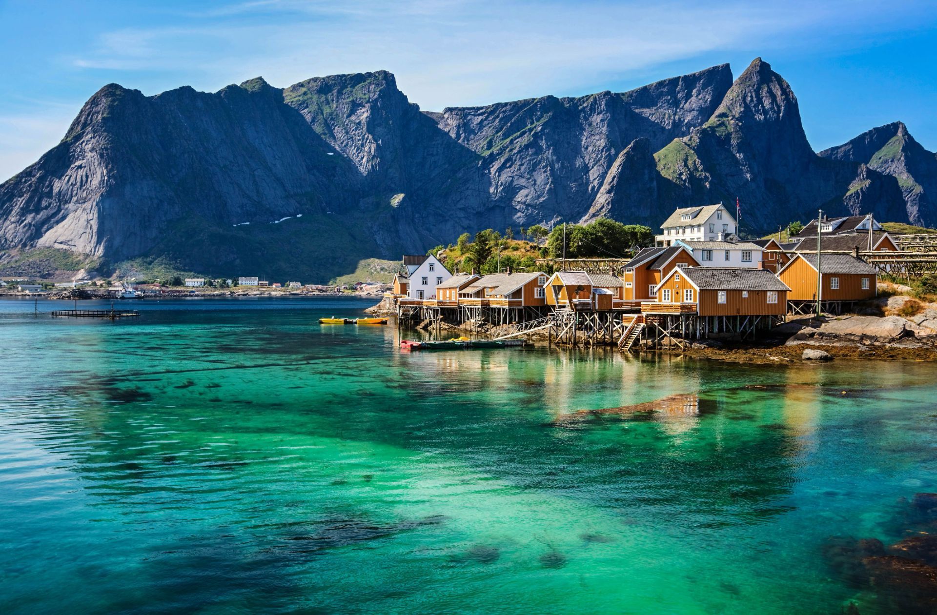
## Description The Lofoten archipelago in northern Norway is known for dramatic mountains rising directly from the sea, sheltered bays dotted with red rorbuer (fishermen’s cabins), and a culture shaped by the cod-fishing season. The islands’ jagged peaks, sheltered fjords and clear northern light create a playground for photographers, hikers and sailors. In summer the midnight sun bathes the landscape in continuous soft light; in winter the aurora borealis weaves curtains above snow-dusted fjords. Lofoten’s distinctiveness lies in the proximity of ocean and mountain: trails often ascend steep ridges that drop into crystal-clear water, and small fishing villages serve as intimate bases for outdoor activities. A lesser-known feature: the islands host significant seabird colonies and seasonal fisheries that have influenced local cuisine and traditions for centuries. Lofoten is not only a visual spectacle but also a destination that rewards slow travel and careful planning. The archipelago's human scale — low-lying villages, narrow winding roads and tiny harbors — means that experiences are tactile and immediate: you can start your day with fresh cod straight from a quay, follow a narrow trail to a windswept summit by afternoon, and end it watching the sea change color as the light shifts. For photographers and naturalists the islands offer a year-round curriculum: in spring and early summer, migrant birds and seals become active along the coastline; in high summer the midnight sun extends golden-hour conditions for long landscape sessions; in autumn the first snows highlight ridgelines and create vivid contrasts; and in winter the long nights are ideal for aurora hunting, provided the skies are clear and weather windows allow. Trail conditions vary widely: some classic hikes like Reinebringen and Kvalvika require stout footwear and a head for exposure, while many coastal walks are family-friendly and can be combined with ferry hops and short drives. Sea-based activities are equally compelling — kayaking through sheltered fjords, joining local fishing trips, or chartering a boat for wildlife watching. Local cultural experiences add texture: museums documenting the seasonal cod fisheries, small artisan shops selling wool and salt-dried fish, and community-run cafés where fishermen swap stories. Food culture in Lofoten remains rooted in the sea; besides stockfish and cod, you’ll encounter local sheep cheeses, cloudberry desserts and a surprisingly well-developed craft-beer scene in a few towns. Practicalities matter in Lofoten. Roads are scenic but narrow, and in winter they can be affected by snow and wind; a flexible itinerary is wise. While many visitors cluster in Reine and Svolvær, quieter pockets such as Henningsvær, Nusfjord and Vinstad reward those who linger. Conservation-minded travel is important: stay on marked trails, respect nesting birds (especially during spring), and support locally owned businesses. Small details like packing waterproof layers, carrying a reliable map or GPS, and learning a few Norwegian phrases will enhance safety and interpersonal encounters. Taken together, these elements make Lofoten an unforgettable destination where dramatic geology, maritime culture and luminous Arctic light combine into a deeply memorable travel experience. ## Location Lofoten lies within Nordland county, above the Arctic Circle, accessible by ferry, road and regional flights from Bodø and Harstad/Narvik airports. The main islands (Austvågøya, Vestvågøya, Flakstadøya and Moskenesøya) are linked by scenic roads and tunnels. The islands are most commonly reached via the E10 highway, which threads the archipelago and connects ferries and causeways. Travelers flying in usually connect through Bodø, which provides ferry and road links, or land at Evenes (near Harstad/Narvik) then drive west. Several regional ferries link the mainland with islands and provide excellent photo opportunities; during summer months additional tourist ferry routes and charter options operate between hotspots like Reine and Svolvær. Car rental is widely available in nearby towns and airports, but public transport is a viable option for those who prefer not to drive, with buses and select ferries serving the larger settlements. ## Tips - **Respect weather windows:** Mountain weather changes rapidly; check local forecasts and prepare with layers and navigation tools. - **Book rorbuer early in summer:** Traditional cabins are popular in high season; reserve in advance. - **Try cod-based cuisine:** Experience local dishes tied to the seasonal stockfish tradition. - **Plan photographic routes:** Sunrise, sunset, and aurora times are key for planning shots; local guides help find hidden vantage points. - **Pack for microclimates:** Conditions can vary from wind-blasted summits to calm fjord inlets in short distances; waterproof outer layers and thermal mid-layers are essential. - **Mind daylight hours:** In summer you can shoot at midnight; in winter plan activities around shorter daylight but prime aurora hours. - **Respect wildlife and nesting areas:** Keep distance from seabird colonies and seal haul-outs to avoid disturbance. - **Rent responsibly or use local guides:** Boat, kayak and fishing charters offer deeper access; choose operators with good safety and sustainability records. - **Bring cash for small purchases:** While cards are widely accepted, some small cafés and stalls may prefer cash in remote villages. ## Conclusion Lofoten combines raw Arctic scenery with a resilient maritime culture, offering dramatic outdoor adventures and timeless coastal charm. Whether you come for the light, the mountains, or the cultural textures of fishing villages, Lofoten rewards curiosity and careful pacing. The islands invite both active exploration and quiet observation — a place to test your kit on rugged trails or simply watch tides and light shift over a year of weathered harbor wood. For travelers prioritizing sustainable, small-scale tourism, Lofoten offers a rich palette of experiences that connect landscape, livelihood and seasonal rhythms. ## FAQ - **Q: When is the best time to visit?** - A: Summer for midnight sun and hiking; winter for northern lights and dramatic snow landscapes. - **Q: Are there guided activities?** - A: Yes — kayaking, hiking, fishing tours and wildlife excursions are widely available. - **Q: Do I need a car to enjoy Lofoten?** - A: A car gives flexibility for reaching remote viewpoints and dispersed villages; however, during summer a combination of buses, ferries and guided tours can cover many highlights without driving. - **Q: How do I plan for aurora viewing?** - A: Check local aurora forecasts and cloud cover, pick dark sites away from town lights, and be patient — clear sky windows are unpredictable. Local guides can increase success rates and handle safety in cold conditions. - **Q: Are trails family-friendly?** - A: Many shoreline walks and lowland trails are suitable for families; some iconic ridgeline hikes are steep and exposed and require good footwear and experience. - **Q: How should I handle food and provisioning?** - A: Larger towns have supermarkets and restaurants; in smaller villages, stockfish shops, local bakeries and seasonal markets offer regional specialties — plan ahead for long drives between services in peak season. ## Links - [Lofoten — Wikipedia](https://en.wikipedia.org/wiki/Lofoten)
GemVoyage Team • World