GemVoyage Team • World
What separates Villa Doria Pamphili from Rome’s better-known manicured gardens is its scale and everyday use: runners training along long straight avenues, families picnicking under broad trees, and musicians gathering informally on sunny afternoons. The park hosts seasonal cultural programs—outdoor concerts, film nights, and neighborhood festivals—yet retains a quiet dignity even during busier times. Its pathways offer both restful, shaded routes and open, sunlit clearings; photographers and nature lovers will appreciate the changing light through the trees and occasional glimpses of Roman rooftops beyond.
The park’s history is visible in its layered landscaping: landscaped terraces that once anchored a noble estate, interspersed with woodland patches that feel older and wilder. For those studying garden history, the site provides a satisfying case study of how aristocratic pleasure grounds transitioned to public urban parks. For ordinary visitors, the pleasures are simpler—ample space, restful atmosphere, and a sense of escape from Rome’s denser historic core.
Q: Are dogs allowed?
A: Dogs are usually permitted on-leash in most areas; check local signage for any leash-free zones or restrictions.
Q: Can I cycle through the park?
A: Yes—many paths are bike-friendly, though some narrower or pedestrian-priority areas may be more suitable for walking.
Q: Are there public restrooms and water fountains?
A: Basic facilities are available but can be limited; carry some water and check maps for restroom locations during longer visits.
Q: Are there guided tours of the park’s history?
A: Occasionally local associations offer guided walks focusing on the villa’s history and gardens—look for community announcements or contact local tourism offices.
Discover more hidden gems you might love.
Alkmaar
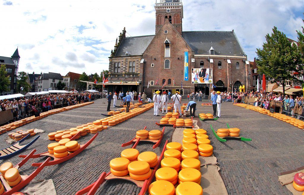
## Description The Alkmaar Cheese Museum is one of the best places to understand why cheese is such an important part of Dutch identity and regional heritage. Located in the historic Waag building, the museum explores the history, production, trade, and cultural significance of cheese in the Netherlands, with special attention to Alkmaar’s long association with the cheese market tradition. It is a compact but engaging museum that helps visitors see cheese not just as food, but as part of a larger economic and social story. One of the museum’s strengths is its accessibility. It presents information in a way that is easy to follow for casual visitors while still giving enough depth to satisfy people interested in local history. The setting matters too: being in a historic weighing house adds a strong sense of place. One lesser-known fact is that Alkmaar’s cheese heritage is linked not only to local farming but also to the broader trading systems that shaped Dutch cities for centuries. Another interesting detail is that the museum helps explain the rituals and practical logistics behind cheese commerce, including how products were measured, moved, and valued in a market town. The museum is also a good reminder that cultural attractions do not have to be large to be effective. Its size makes it easy to fit into a walking day in Alkmaar, and it works especially well when combined with the city’s old streets, canals, and other historic sites. For many visitors, the appeal is partly culinary and partly atmospheric: you learn about cheese, but you also absorb the character of a Dutch market city that built part of its identity around this trade. That makes the museum feel both educational and local. ## Location The Alkmaar Cheese Museum is in the center of Alkmaar, North Holland, the Netherlands, inside the historic Waag building near the city’s old market area. Because it is centrally located, it is easy to reach on foot from most of Alkmaar’s historic core. If you are coming by train, Alkmaar’s station connects well to the city center, and the walk to the museum is straightforward. Visitors arriving from Amsterdam or other nearby cities usually find the trip simple by rail, making it a practical day trip destination. Once in town, the compact center is best explored on foot. ## Tips Combine the museum with a visit to Alkmaar’s historic center for the full experience. If you are interested in the traditional cheese market, check the schedule before your trip so you can align your visit. The museum is a good rainy-day option because it is compact and easy to visit without much planning. Leave room in your itinerary for tasting local cheese or exploring nearby shops. ## Conclusion The Alkmaar Cheese Museum is a small but worthwhile stop that turns the city’s cheese heritage into a clear and enjoyable cultural visit. ## FAQ ### What does the Alkmaar Cheese Museum focus on? It explains the history, trade, and cultural importance of cheese in Alkmaar and the Netherlands. ### Is the museum connected to the cheese market? Yes, it is closely tied to Alkmaar’s famous cheese-trading tradition. ### How much time do I need? A visit usually takes around one hour, depending on how much you read. ### Is it suitable for children? Yes, especially for families that want a short, easy museum visit with a clear theme. ### Can I visit it together with the cheese market? Yes, and that is one of the best ways to experience Alkmaar’s cheese culture. ## Links - [Official website](https://www.kaasmuseum.nl/en/)
GemVoyage Team • World
Seoul
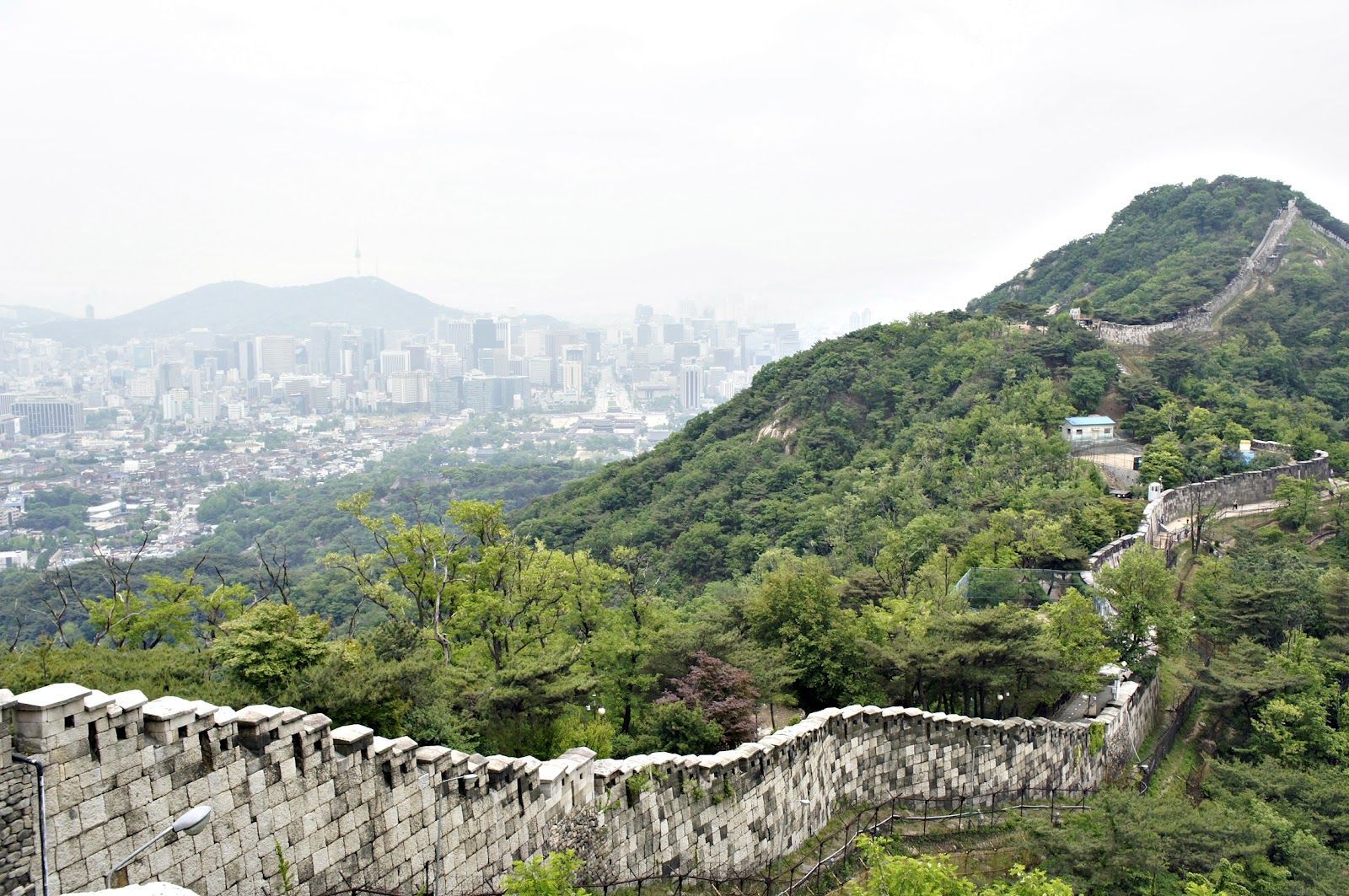
## Description The Seoul Fortress Wall traces the historic boundary of old Seoul, and the Inwangsan section is one of the most compelling short hikes inside the city. Winding stone walls, watchtowers, and narrow ridgelines create a dramatic contrast between rugged natural rock and the modern urban panorama below. Inwangsan (인왕산) itself is a modest peak by elevation, but its steep faces and rocky outcrops make the Fortification route visually striking and surprisingly variable: you pass restored wall segments, crenellated parapets, traditional gates, and quieter stretches where the original stonework blends into pine and ginkgo trees. This route is part walking trail, part living history. Along the Inwangsan section, you can stand at viewpoints that look directly toward Gyeongbokgung Palace and central Seoul, making it a favorite for photographers who want a skyline shot with a distinctly Korean architectural foreground. The combination of natural features and preserved cultural sites gives the trail strong context—archaeologists and local historians point to ritual sites and small petroglyphs on some of the rocky ledges, evidence that the hill has been significant for much longer than the Joseon-era fortifications. For travelers who prioritize accessible day hikes, Inwangsan is practical: the trails are short enough to be combined with a half-day of exploring nearby neighborhoods (Seochon, Buam-dong, or the area around Gyeongbokgung). The experience can feel intimate and unhurried, especially outside popular weekends. For SEO and practical trip planning, search terms that pair well with this route are "Seoul Fortress Wall Inwangsan hike", "Inwangsan panoramic views", and "Seoul city wall trail Gyeongbokgung viewpoint"—phrases locals and travel platforms commonly use. ## Location Inwangsan rises above central Seoul and is most easily accessed on foot from neighborhoods close to Gyeongbokgung Palace and Hyehwa. Nearby subway stations include Gyeongbokgung Station (Line 3) and Hyehwa Station (Line 4); from either point, a 10–25 minute walk brings you to the trailheads depending on your route. Many visitors combine a morning or afternoon at Gyeongbokgung with a short hike up Inwangsan to make efficient use of time. Public transit directions are straightforward: take the subway to Gyeongbokgung or Hyehwa, then follow signs toward the fortress wall trail or ask at local cafes. There are several access points—some are steeper and more direct, others weave through residential lanes and feel more gradual. Maps and local wayfinding often label the path as part of the Seoul City Wall trail network—which helps when using mapping apps or planning a multi-stop day. ## Tips - Hike in the cooler parts of the day: early morning or late afternoon provides the best light for photos and avoids midday crowds and heat. - Wear supportive shoes: some stretches are rocky and uneven; closed-toe hiking shoes or trail runners are recommended. - Bring water and a light snack: although the trail is short, the elevation gain and rocky scrambles benefit from hydration and quick energy. - Be mindful of cultural sites: certain rock ledges and small shrines are used for ritual or prayer—treat them respectfully and avoid disturbing offerings. - Use a map or offline navigation: parts of the trail pass behind residential areas and signage can be minimal; a downloaded map or route screenshot helps. - Combine with nearby visits: pair the hike with a visit to Gyeongbokgung Palace, Seochon’s galleries, or the Buam-dong cafes to make a full half-day itinerary. - Photography tip: for skyline shots with the palace, position yourself on the western-facing viewpoints late in the afternoon for warm light on the stone walls and cool city contrasts. ## Conclusion The Inwangsan section of the Seoul Fortress Wall blends accessible urban hiking with layered history and excellent skyline views. It’s ideally suited for travelers who want a short outdoor escape with high visual return and cultural interest. Whether you pause for a skyline photograph, linger at a watchtower, or simply enjoy the contrast of stone and city, Inwangsan rewards an inquisitive walk and mixes well with central Seoul sightseeing. ## FAQ Q: How long does the Inwangsan trail take? A: Typical loop or ascent routes take 45–90 minutes depending on pace, photo stops, and which trailhead you pick. Q: Is the trail suitable for children or older visitors? A: Many sections are family-friendly, but some parts include short rocky scrambles and steps—evaluate mobility and consider shorter, lower-angle access routes for older visitors. Q: Are parts of the wall restricted or closed at certain times? A: Most sections are open to the public daily, but occasional restoration work or local ceremonies can temporarily limit access—check local signage or community updates. Q: Can I climb on the walls and gates? A: For safety and preservation, avoid climbing on fragile stonework; use designated paths and viewpoints to minimize wear on historic structures. Q: Is there an entrance fee or permit needed? A: No entrance fee—this is a publicly accessible municipal trail and heritage site. ## Links - [Seoul City Wall (Wikipedia)](https://en.wikipedia.org/wiki/Seoul_City_Wall)
GemVoyage Team • World
.jpg)
Scotland
## Description The Fairy Pools on the Isle of Skye in Scotland are a series of crystal-clear, aqua-blue pools and cascading waterfalls that tumble down from the foothills of the Black Cuillin mountains. These natural pools, fed by the Allt Coire a’ Mhadaidh stream, are renowned for their ethereal beauty and have become one of Skye’s most iconic and photographed attractions. Whether you're a hiker, wild swimmer, or simply a lover of dramatic landscapes, the Fairy Pools offer a magical experience that feels straight out of folklore. The walk to the pools is relatively short—about 2.4 kilometers round trip—and follows a well-maintained gravel path that winds through heather-covered moorland. Along the way, visitors encounter a series of waterfalls and pools, each more striking than the last. The water is so clear that you can see the rocky bottoms and reflections of the surrounding hills, making it a favorite spot for photographers and nature enthusiasts. A little-known fact: the area around the Fairy Pools was the site of the last and bloodiest clan battle in Scottish history—the Battle of Coire na Creiche in 1601 between the MacLeods of Dunvegan and the MacDonalds of Sleat. Legend has it that the stream ran red with blood, a stark contrast to its current tranquil appearance. Another quirky detail is that despite their name, there’s no historical association with fairies—the name “Fairy Pools” only began appearing in guidebooks in the 20th century. ## Location The Fairy Pools are located in **Scotland**, on the **Isle of Skye**, near the village of **Carbost** in the **Highland region**. They sit at the base of the Black Cuillin mountains in **Glen Brittle**, on the western side of the island. ### How to Get There - **By Car**: From Portree, the island’s main town, it’s about a 30-minute drive (20.5 miles) via the B8009 and Glenbrittle road. The route includes single-track roads with passing places. - **By Bus**: Public transport is limited. Buses run to Carbost, but you’ll need to arrange a taxi or walk from there. - **By Tour**: Several guided tours from Portree or Inverness include the Fairy Pools as part of a day trip. - **By Foot**: The walk to the pools begins at the Fairy Pools car park, located near Glenbrittle. From the car park, it’s a 20-minute walk to the first waterfall. ## Tips - **Visit Early or Late**: The site gets crowded during peak hours, especially in summer. Early morning or late afternoon offers better light and fewer visitors. - **Wear Waterproof Footwear**: The path can be muddy and uneven, especially after rain. - **Bring Layers**: Weather on Skye is unpredictable. Pack a waterproof jacket and warm clothing. - **Wild Swimming**: Brave souls can swim in the pools, but the water is icy year-round. A wetsuit is recommended. - **Respect Nature**: Follow the Scottish Outdoor Access Code—take your litter with you and stick to marked paths. - **Parking**: There is a charge for parking at the Fairy Pools car park, which helps maintain the site. ## Conclusion The Fairy Pools on the Isle of Skye are a breathtaking blend of natural beauty and Highland mystique. With their vivid waters, dramatic mountain backdrop, and rich history, they offer a memorable experience for anyone exploring Scotland’s rugged landscapes. ## FAQ **1. Is there an entrance fee to visit the Fairy Pools?** No, the pools are free to visit, but there is a charge for parking. **2. How long is the walk to the Fairy Pools?** The round-trip walk is approximately 2.4 kilometers and takes 40 minutes to 1.5 hours depending on pace and stops. **3. Can I swim in the Fairy Pools?** Yes, wild swimming is allowed, but the water is extremely cold. A wetsuit is recommended. **4. Are the Fairy Pools suitable for children?** Yes, but children should be supervised due to uneven terrain and cold water. **5. Is the site wheelchair accessible?** No, the terrain is rugged and includes steep inclines, making it unsuitable for wheelchairs. **6. What is the best time of year to visit?** Spring and autumn offer mild weather and fewer crowds. Summer is busiest, while winter can be icy and less accessible. ## Links - [Fairy Pools Walk – Isle of Skye Guide](https://www.isleofskye.com/skye-guide/top-ten-skye-walks/fairy-pools) - [Fairy Pools – VisitScotland Overview](https://www.visitscotland.com/info/see-do/fairy-pools-p1770011) - [Fairy Pools – Wikipedia Entry](https://en.wikipedia.org/wiki/Fairy_Pools) Description The Fairy Pools on the Isle of Skye in Scotland are a series of crystal-clear, aqua-blue pools and cascading waterfalls that tumble down from the foothills of the Black Cuillin mountains. These natural pools, fed by the Allt Coire a’ Mhadaidh stream, are renowned for their ethereal beauty and have become one of Skye’s most iconic and photographed attractions. Whether you're a hiker, wild swimmer, or simply a lover of dramatic landscapes, the Fairy Pools offer a magical experience that feels straight out of folklore. The walk to the pools is relatively short—about 2.4 kilometers round trip—and follows a well-maintained gravel path that winds through heather-covered moorland. Along the way, visitors encounter a series of waterfalls and pools, each more striking than the last. The water is so clear that you can see the rocky bottoms and reflections of the surrounding hills, making it a favorite spot for photographers and nature enthusiasts. A little-known fact: the area around the Fairy Pools was the site of the last and bloodiest clan battle in Scottish history—the Battle of Coire na Creiche in 1601 between the MacLeods of Dunvegan and the MacDonalds of Sleat. Legend has it that the stream ran red with blood, a stark contrast to its current tranquil appearance. Another quirky detail is that despite their name, there’s no historical association with fairies—the name “Fairy Pools” only began appearing in guidebooks in the 20th century. Location The Fairy Pools are located in Scotland, on the Isle of Skye, near the village of Carbost in the Highland region. They sit at the base of the Black Cuillin mountains in Glen Brittle, on the western side of the island. How to Get There By Car: From Portree, the island’s main town, it’s about a 30-minute drive (20.5 miles) via the B8009 and Glenbrittle road. The route includes single-track roads with passing places. By Bus: Public transport is limited. Buses run to Carbost, but you’ll need to arrange a taxi or walk from there. By Tour: Several guided tours from Portree or Inverness include the Fairy Pools as part of a day trip. By Foot: The walk to the pools begins at the Fairy Pools car park, located near Glenbrittle. From the car park, it’s a 20-minute walk to the first waterfall. Tips Visit Early or Late: The site gets crowded during peak hours, especially in summer. Early morning or late afternoon offers better light and fewer visitors. Wear Waterproof Footwear: The path can be muddy and uneven, especially after rain. Bring Layers: Weather on Skye is unpredictable. Pack a waterproof jacket and warm clothing. Wild Swimming: Brave souls can swim in the pools, but the water is icy year-round. A wetsuit is recommended. Respect Nature: Follow the Scottish Outdoor Access Code—take your litter with you and stick to marked paths. Parking: There is a charge for parking at the Fairy Pools car park, which helps maintain the site. Conclusion The Fairy Pools on the Isle of Skye are a breathtaking blend of natural beauty and Highland mystique. With their vivid waters, dramatic mountain backdrop, and rich history, they offer a memorable experience for anyone exploring Scotland’s rugged landscapes. FAQ 1. Is there an entrance fee to visit the Fairy Pools? No, the pools are free to visit, but there is a charge for parking. 2. How long is the walk to the Fairy Pools? The round-trip walk is approximately 2.4 kilometers and takes 40 minutes to 1.5 hours depending on pace and stops. 3. Can I swim in the Fairy Pools? Yes, wild swimming is allowed, but the water is extremely cold. A wetsuit is recommended. 4. Are the Fairy Pools suitable for children? Yes, but children should be supervised due to uneven terrain and cold water. 5. Is the site wheelchair accessible? No, the terrain is rugged and includes steep inclines, making it unsuitable for wheelchairs. 6. What is the best time of year to visit? Spring and autumn offer mild weather and fewer crowds. Summer is busiest, while winter can be icy and less accessible. Links Fairy Pools Walk – Isle of Skye Guide Fairy Pools – VisitScotland Overview Fairy Pools – Wikipedia Entry 715 words37 lines4484 characters4520 bytes
GemVoyage Team • World
Vancouver
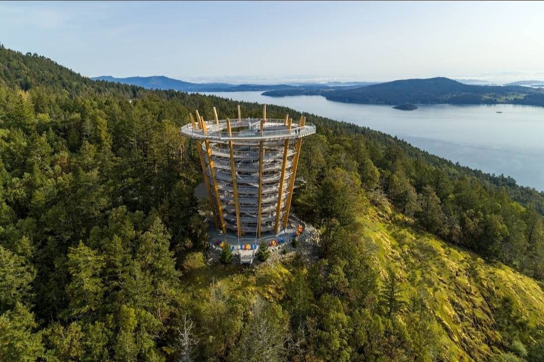
## Description The **Malahat SkyWalk Spiral Tower** is one of Canada’s most spectacular outdoor attractions, offering visitors an unforgettable way to experience the natural beauty of Vancouver Island. This unique tower features a gently sloping spiral ramp that winds its way upward for over 600 meters, leading to a stunning 250-meter elevated walkway through the treetops. At the very top, visitors are rewarded with **360-degree panoramic views** of the Saanich Peninsula, the Gulf Islands, Mount Baker in Washington State, and even glimpses of the Coast Mountains. What makes this destination truly remarkable is its **architectural design that blends seamlessly into nature**. The tower is constructed primarily from locally sourced Douglas fir and steel, combining eco-friendly practices with modern engineering. Unlike traditional observation decks, the spiral walkway makes it fully accessible to people of all ages and mobility levels. A little-known fact about the Malahat Spiral Tower is the **adventure net**—a giant webbed net suspended high above the ground at the tower’s summit. Brave visitors can step onto it and look straight down through the open center of the tower for a thrilling perspective. Another hidden gem is the **45-meter-long spiral slide** that winds its way down the inside of the tower, offering kids and adults alike an exciting alternative to walking back down. ## Location The Malahat SkyWalk Spiral Tower is located on **southern Vancouver Island, British Columbia, Canada**, about 35 kilometers (roughly 40 minutes) north of **Victoria**, the provincial capital. It sits along the Malahat Highway (Highway 1), a scenic route known for its breathtaking coastal views and winding mountain roads. The attraction is easily accessible by car, making it a popular day trip from Victoria. Visitors traveling from Vancouver can reach it by taking a ferry to Swartz Bay and then driving south toward Victoria before heading north on the Malahat Highway. For those without a car, guided tours from Victoria are also available and often include other nearby highlights. **Recommendation:** If possible, plan your visit in the morning to avoid crowds and enjoy the crisp air and soft lighting, which make the views even more magical. ## Tips To make the most out of your visit to the Malahat Spiral Tower, here are some helpful tips: * **Wear comfortable shoes:** The spiral ramp is easy to walk but requires a fair bit of strolling, so good footwear makes the experience more enjoyable. * **Check the weather:** The best views are on clear days when you can see as far as Mount Baker and the Gulf Islands. * **Try the slide:** Don’t miss the spiral slide inside the tower—it’s safe, fun, and a unique way to descend. * **Bring a camera or binoculars:** Wildlife sightings are common, including eagles, ravens, and deer in the surrounding forest. * **Buy tickets in advance:** To save time, purchase tickets online, especially during summer and holiday seasons. * **Accessibility:** The entire walkway and tower are stroller- and wheelchair-friendly, making it a great destination for families. ## Conclusion The **Malahat SkyWalk Spiral Tower** isn’t just an observation deck—it’s a full sensory experience that blends nature, adventure, and breathtaking views. From the treetop walkway to the thrill of the spiral slide and the panoramic views of land and sea, it offers something for everyone. Whether you’re a nature lover, a family traveler, or simply looking for an unforgettable outing near Victoria, this attraction deserves a spot on your bucket list. ## FAQ **1. How long does it take to visit the Malahat SkyWalk Spiral Tower?** Most visitors spend between 1.5 to 2 hours exploring the treetop walkway, climbing the spiral tower, and enjoying the views. **2. Is the Malahat SkyWalk open year-round?** Yes, it’s open in all seasons, though hours may vary. Each season offers a different experience—from lush green summers to snow-dusted winter landscapes. **3. Is the Malahat SkyWalk suitable for kids?** Absolutely! Children love the slide, and the walkway is stroller-friendly, making it a perfect family activity. **4. Can I bring my dog to the Malahat SkyWalk?** Yes, dogs on leashes are welcome along the treetop walk and the spiral tower, though they’re not allowed on the slide. **5. Is the attraction wheelchair accessible?** Yes, the entire pathway and spiral ramp are designed to be fully accessible for wheelchairs and strollers. ## Links For more information, tickets, and updates, visit these official and helpful resources: * [Malahat SkyWalk Official Website](https://malahatskywalk.com)
GemVoyage Team • World
Sedgefield
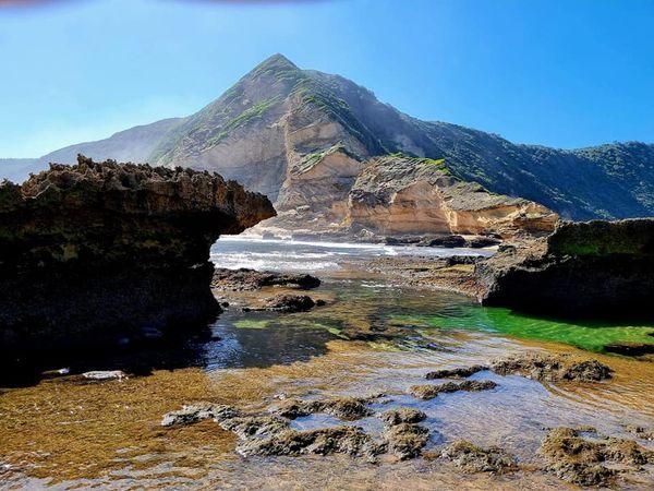
## Description **Gericke’s Point** is one of the hidden gems of South Africa’s Garden Route. Famous for its striking sandstone cliff that resembles the profile of a lion’s head, this natural landmark offers both geological beauty and incredible biodiversity. At low tide, the area transforms into a natural aquarium, revealing tidal pools brimming with colorful marine life such as starfish, sea anemones, and small fish. The rock formation itself is over 150 million years old, part of the ancient Table Mountain sandstone system. Its unusual shape and size make it one of the most photogenic spots along the coast. Beyond its geology, Gericke’s Point is also a birdwatcher’s paradise, with seabirds often seen diving for fish and dolphins occasionally passing offshore. A little-known fact is that the tidal pools here are considered some of the most diverse along the Garden Route, making it a favorite spot for marine biologists and nature enthusiasts. Another fascinating detail is that the rock face has long been a landmark for sailors navigating the coast between Sedgefield and Wilderness. ## Location Gericke’s Point is located near **Sedgefield**, a small town along the **Garden Route** in the **Western Cape Province** of **South Africa**. It lies about 25 kilometers from Knysna and around 40 kilometers from George. To reach the point, visitors typically start at Swartvlei Beach near Sedgefield. From there, a scenic beach walk of about 2–3 kilometers leads to the rock formation. The best time to go is at low tide, when the tidal pools are accessible and the walk is safe. Travelers driving the Garden Route can easily stop at Sedgefield, with parking available near the beach entrance. ## Tips * **Check the tide tables:** Low tide is the only safe and rewarding time to visit. High tide can make the walk dangerous. * **Wear sturdy shoes:** Although the walk is along the beach, exploring the tidal pools requires footwear with good grip. * **Bring a camera:** The lion-shaped rock formation and vibrant tidal pools make for excellent photography opportunities. * **Pack water and sun protection:** There are no facilities along the beach walk, so carry essentials with you. * **Respect marine life:** Avoid disturbing or removing creatures from the tidal pools—this is a fragile ecosystem. * **Stay for sunset:** The area is particularly stunning in the golden light of late afternoon, with the rock formation silhouetted against the ocean. ## Conclusion Gericke’s Point is more than just a rock formation—it is a window into South Africa’s geological past and a living showcase of coastal biodiversity. With its tidal pools, dramatic cliffs, and sweeping ocean views, it offers a perfect mix of adventure and tranquility along the Garden Route. For travelers seeking a memorable nature experience off the beaten path, Gericke’s Point is not to be missed. ## FAQ **1. How long is the walk to Gericke’s Point?** The walk from Swartvlei Beach to Gericke’s Point takes about 30–40 minutes each way, depending on pace and tide conditions. **2. Is it safe to swim near Gericke’s Point?** Swimming is possible in some tidal pools, but the open ocean can be rough. Always exercise caution and avoid strong currents. **3. Can children visit the point?** Yes, children often enjoy exploring the tidal pools, but they should be supervised closely due to slippery rocks and the incoming tide. **4. Is there an entrance fee?** No, Gericke’s Point is free to access, though parking at Swartvlei Beach may sometimes require a small fee. **5. What wildlife might I see?** In addition to tidal pool creatures, visitors may spot dolphins offshore, oystercatchers, and other seabirds. In whale season (June–November), southern right whales are sometimes visible. **6. When is the best time to visit?** The best time is at low tide and preferably in the morning or late afternoon when temperatures are milder and light conditions are ideal. ## Links * [Visit Garden Route – Sedgefield](https://www.visitgardenrouteandkleinkaroo.com) * [South African Tourism – Garden Route](https://www.southafrica.net)
GemVoyage Team • World
.jpg)
Schwerin
## Description Schwerin Castle (Schloss Schwerin) is one of Germany’s most enchanting and architecturally rich palaces, often referred to as the “Neuschwanstein of the North.” Located on an island in Lake Schwerin, this fairytale-like fortress is a masterpiece of Romantic historicism, blending Gothic, Renaissance, and Baroque elements into a harmonious whole. With its golden domes, ornate towers, and intricate façade, the castle appears to rise magically from the water, captivating visitors from every angle. Originally built as a fort in the 10th century by the Slavic Obotrites, the site evolved over centuries into a ducal residence. The current structure was largely completed between 1845 and 1857, designed by a team of renowned architects including Gottfried Semper and Friedrich August Stüler. Today, Schwerin Castle houses the state parliament of Mecklenburg-Vorpommern, a museum showcasing 19th-century art and furnishings, and hosts cultural events such as open-air theatre performances. A little-known fact: Schwerin Castle contains 635 rooms, many of which are lavishly decorated with gilded ceilings, carved woodwork, and elaborate tapestries. Another intriguing detail is the legend of the castle ghost, Petermännchen—a benevolent spirit said to protect the castle and its inhabitants. ## Location Schwerin Castle is located in **Germany**, in the **state of Mecklenburg-Vorpommern**, within the **city of Schwerin**. It sits on a small island in **Lake Schwerin**, connected to the mainland by bridges and surrounded by beautifully landscaped gardens and parkland. ### How to Get There - **By Train**: From Hamburg or Berlin, take a regional train to Schwerin Hauptbahnhof. The castle is a 15-minute walk from the station. - **By Car**: Schwerin is easily accessible via the A14 and A24 motorways. Parking is available near the castle. - **By Bus**: Local buses stop at Schloss Schwerin or nearby Lennéstraße. - **By Foot**: The city center is compact and walkable, making it easy to reach the castle on foot from most hotels and attractions. Its central location makes it ideal for a day trip or a weekend getaway from major northern German cities. ## Tips - **Visit the Museum**: The castle museum spans three floors and includes the Throne Room, Gallery of Ancestors, and opulent living quarters. - **Explore the Gardens**: The surrounding park and gardens are free to enter and offer stunning views of the castle and lake. - **Check Opening Hours**: The museum is open Tuesday to Sunday, with seasonal variations. Last entry is 30 minutes before closing. - **Use an Audioguide**: Available for a small fee, audioguides provide rich historical context and are free for children. - **Attend Cultural Events**: Look out for concerts, exhibitions, and theatrical performances held in the castle courtyard. - **Photography**: The exterior is a photographer’s dream, especially at sunrise or sunset. Interior photography may be restricted in some rooms. ## Conclusion Schwerin Castle is a stunning blend of history, architecture, and natural beauty. With its lakeside setting, lavish interiors, and rich cultural heritage, it offers a magical experience that’s both visually and intellectually rewarding. ## FAQ **1. What are the opening hours of Schwerin Castle?** April to October: Tuesday–Sunday, 10:00 AM–6:00 PM October to April: Tuesday–Sunday, 10:00 AM–5:00 PM **2. What is the entrance fee?** Adults: €8.50 Reduced: €6.50 Children under 18: Free Audioguide: €2.00 (free for children) **3. Is Schwerin Castle suitable for children?** Yes, children are welcome and can enjoy the gardens, museum exhibits, and ghost stories. **4. Can I take photos inside the castle?** Photography is allowed in most areas, but flash and tripods may be restricted. **5. Is the castle wheelchair accessible?** Parts of the museum and gardens are accessible, but some historic areas may have limited access. **6. How long should I plan for a visit?** Allow 2–3 hours to explore the museum and gardens thoroughly. ## Links - [Schwerin Castle – Wikipedia Overview](https://en.wikipedia.org/wiki/Schwerin_Castle) - [Schwerin Castle – Mecklenburg Tourism Guide](https://www.mecklenburg-schwerin.de/en/sights/schwerin-and-schwerin-castle/schwerin-castle/)
GemVoyage Team • World

Comments