GemVoyage Team • World
Inside, MAAT presents a mix of international and local artists, with a particular interest in projects that engage new media, digital art, and design. The museum’s programming frequently includes public talks, workshops for families, and collaborations with design festivals—evidence of its ambition to operate as a civic platform rather than a static collection. The building’s rooftop terrace is itself a public amenity, offering panoramic views across the Tagus River and serving as a flexible event space for outdoor performances and gatherings.
MAAT’s curatorial approach is often experimental, pairing architectural interventions with media installations and time-based works that reward repeat visits. For visitors, this means each visit can feel different: sometimes the highlight is a single striking installation, other times the rooftop programming and view become the defining memory. The museum’s thoughtfully designed visitor flow and bilingual signage make it accessible to tourists and locals alike.
Q: Is MAAT family-friendly?
A: Definitely—MAAT offers family workshops and programs designed to engage younger visitors, though some installations may have age recommendations.
Q: Are English guides available?
A: Many exhibitions and staff resources are available in English; check the information desk for guide options or multilingual materials.
Q: Can I visit the rooftop without entering the galleries?
A: Policies vary—sometimes rooftop access is included with general admission, while special events may require a separate ticket; check the museum’s website.
Q: Is photography allowed inside?
A: Non-flash photography is generally allowed in public galleries, but some works and special exhibitions may prohibit photography—obey posted restrictions.
Discover more hidden gems you might love.
Lisbon
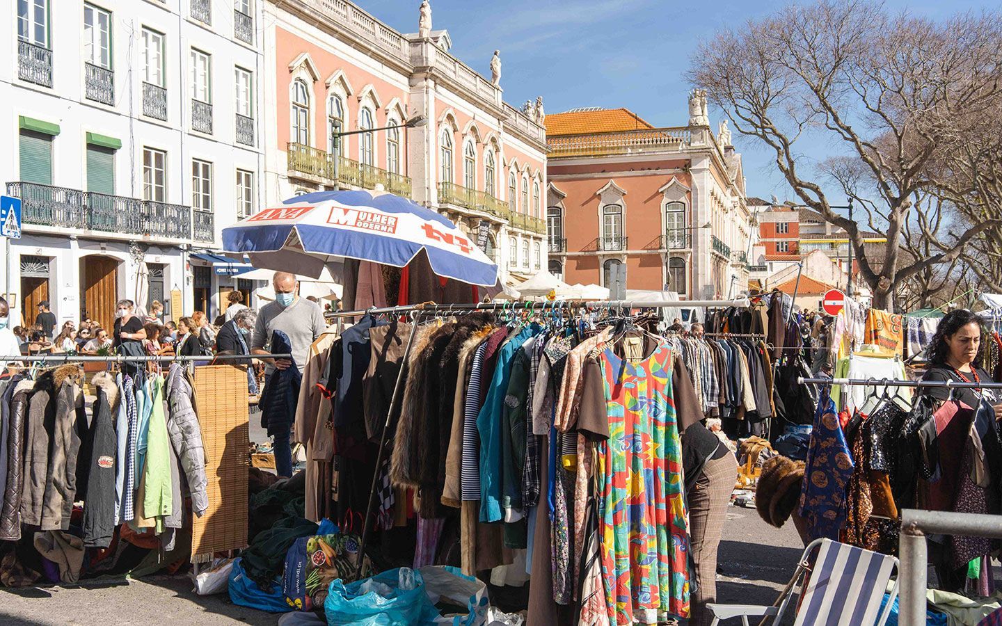
## Description Feira da Ladra is Lisbon’s most atmospheric flea market, a living patchwork of Portuguese life, history and commerce. More than a simple collection of stalls, it functions as a social square where generations of Lisboetas and visitors mingle among secondhand fabrics, antique furniture, faded postcards and artisan curios. The market’s energy is tactile and sensory: the smell of roasted chestnuts on a cool morning, the clack of wooden crates being stacked, and the low negotiation voices that form an audible backdrop to careful inspection of objects that often carry long personal histories. The market’s layout is informal and sprawling across Campo de Santa Clara and adjacent streets, which gives Feira da Ladra a serendipitous quality. Shoppers come for the big-ticket antiques as often as for tiny discoveries — old postcards that reveal vanished streets, or a single ceramic shard that hints at an earlier factory’s palette. Stallholders tend to be people who work in niches: collectors who’ve spent years sourcing porcelain and glass, families passing down boxes of personal effects, or young makers showcasing vintage-inspired handicrafts. That variety is exactly what makes the market valuable for cultural and material history research as well as for treasure hunting. Historically, the name "Feira da Ladra" — literally "thief’s fair" — is layered in nuance rather than literal accusation. Its origin reflects an age when informal markets, barter and secondhand trade were common ways to redistribute goods brought by sailors, seasonal workers and small-time traders. Over centuries, the market evolved from ad-hoc trading to an organized, municipally permitted event; yet it has preserved that improvisational spirit. Locals often stroll the market not just to shop but to socialize, to enjoy street food and to find oddities that become stories to tell. From a visitor’s perspective, Feira da Ladra rewards patience and curiosity. The most memorable finds are rarely the first item seen; rather, they emerge from methodical, slow browsing and conversations with vendors. For photographers and writers, the market provides rich visual and narrative material: candid portraits, evocative still lifes and oral histories that surface in impromptu discussions. For collectors, the market can be a source of rare pieces — old military medals, ill-fitted mirrors with gilded frames, and long-forgotten vinyl records — provided you take the time to look beyond the more tourist-oriented stands. To add practical depth: prices at Feira da Ladra vary widely, from a few euros for secondhand books to hundreds or thousands for verified antiques. If you are buying a significant artifact, ask for provenance information and vendor contact details; many dealers will provide a short history or provenance note for higher-value items. If you're an academic or conservator, the market can be a useful place to connect with sources, restorers and individuals who work in regional crafts. Conversations at stalls often yield unexpected context — the name of a maker, the story of how an item arrived in Portugal, or a tip about a specialist restorer in nearby neighborhoods. For visitors who want a focused approach, consider creating a short checklist: categories of interest (textiles, ceramics, books), approximate size limits for what you can carry, and a preliminary budget. This lets you sift quickly while staying alert for serendipity. Photographers may want to prioritize early hours when stalls are being set up; the quality of light in the plaza and narrow alleys often enhances texture and color in ways that late-day crowds do not. ## Location Feira da Ladra is anchored in Campo de Santa Clara, a broad plaza in Lisbon’s Alfama quarter, a neighborhood known for winding alleys, Fado houses and terraced viewpoints. The market commonly takes place on Tuesdays and Saturdays, though schedules can vary for holidays and municipal regulations — always verify current opening days before traveling. Getting there: the iconic Tram 28 winds through Alfama and stops within reasonable walking distance of Campo de Santa Clara, offering a scenic approach that doubles as a short city tour. For those who prefer other transit, buses and the nearby Santa Apolónia train station provide alternatives. Driving is possible but parking in central Lisbon is limited; rideshares and taxis are convenient options. Because the market sprawls across cobbled streets, wear sturdy shoes and be prepared for narrow passages. Insider transit tip: if you’re trying to avoid the busiest hours on Saturdays, arrive just after opening or target a Tuesday visit. Weekdays mean fewer tourists and better chances to speak with long-term stallholders. Also note that in summer months local festivals and holiday schedules can push setup times earlier or later. ## Tips - Visit early: stalls are fresher and the best items are still available in the morning. - Bring small bills and coins: many vendors prefer cash and it speeds up negotiations. - Learn a few Portuguese phrases for polite bargaining; a warm greeting goes far. - Inspect goods carefully — antiques and vintage items can have hidden damage. - Pack a reusable bag and a small tape measure; some items will need measurements. - Leave time to explore Alfama after the market: viewpoints, narrow streets, and authentic eateries nearby make for a full day. - Respect vendors: ask before photographing and approach trades with courtesy. - If planning larger purchases, discuss delivery options in advance; some vendors have recommended couriers and can help with packing. - Consider bringing a handheld UV light if you’re assessing paper items and stamps — it helps detect repairs and alterations (use respectfully and sparingly). ## Conclusion Feira da Ladra is more than a market: it’s a cultural habit of Lisbon, where history, economy, and daily life intersect. The market rewards visitors who slow down, ask questions and let discoveries find them. Whether you’re a focused collector, a photographer seeking texture and color, or a traveler searching for a distinctive souvenir, Feira da Ladra offers an authentic experience rooted in local rhythms and old-world charm. Suggested half-day itinerary: arrive at opening, walk the perimeter for an overview, focus on two or three categories of interest, take a mid-morning coffee at a nearby cafe, and return for a second pass before noon to finalize purchases. This rhythm helps you avoid decision fatigue and increases the chance of discovering a meaningful item. ## FAQ Q: When is Feira da Ladra open? A: The market normally runs on Tuesdays and Saturdays, with the largest crowds on Saturday mornings. Special municipal events, public holidays, or seasonal adjustments may change the schedule — check local listings or municipal websites for the latest calendar. Q: Is haggling acceptable and common? A: Yes. Polite bargaining is part of the experience, especially for antiques and larger items. Start with a respectful offer and keep interactions friendly; vendors are more likely to lower prices for warm, patient customers. Q: What should I bring to shop at Feira da Ladra? A: Bring cash (small denominations), a sturdy bag for purchases, comfortable shoes, and a phone or notebook to capture vendor details if you’re researching a find. If you plan to purchase large items, have transportation arranged in advance. Q: Are there authentic antiques or mostly tourist souvenirs? A: You’ll find a mix. Some stalls explicitly cater to tourists with souvenirs, but many dealers and long-term stallholders sell genuinely antique or collectible items. Careful browsing and asking informed questions helps locate authentic pieces. Q: Is the market family-friendly and safe? A: Generally yes — it’s a lively neighborhood market with families, collectors, and tourists. Standard urban precautions apply: watch your belongings, be mindful in crowded aisles, and avoid displaying large sums of cash. ## Links - [Wikipedia: Feira da Ladra](https://en.wikipedia.org/wiki/Feira_da_Ladra) - [Lisbon tourism info (markets)](https://www.visitlisboa.com)
GemVoyage Team • World
Tokyo
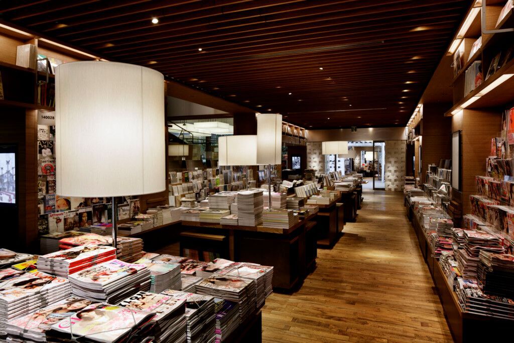
## Description Daikanyama T-Site is one of Tokyo’s most refined and visually appealing neighborhood destinations, and it stands out because it turns a bookstore into a complete lifestyle experience. Rather than being a single shop filled with shelves and cash registers, it is a carefully designed complex of books, magazines, cafés, architecture, and leisurely browsing spaces. Visitors come expecting to buy books, but many leave with a broader sense that they have spent time in a sophisticated urban retreat. The site is known for its elegant design and calm atmosphere, which feel especially striking in a city as fast and dense as Tokyo. Inside and around the complex, the pace slows. You can browse titles with no rush, sit down with coffee, and watch the neighborhood move at a gentler rhythm. That contrast is a big part of why Daikanyama T-Site is so loved by locals and travelers alike. It is not trying to compete with Tokyo’s biggest entertainment districts. Instead, it offers a more intimate and curated version of city life. One little-known fact is that the site is closely associated with Tsutaya’s concept of combining culture, retail, and hospitality into one seamless environment. Another is that the architecture and landscaping were designed to encourage lingering rather than quick transactions. You are meant to wander, pause, and discover. For travelers, this makes it a rare kind of attraction: a place that feels both commercially polished and genuinely calming. Daikanyama itself adds to the appeal. The neighborhood is known for its fashionable streets, independent boutiques, and a more residential, upscale feel compared with Tokyo’s more frenetic districts. That means a visit to T-Site works well as part of a relaxed afternoon spent exploring coffee shops, design stores, and quiet streets. Even if you are not a heavy reader, the atmosphere is enough to justify the stop. ## Location Daikanyama T-Site is in the Daikanyama neighborhood of Shibuya, Tokyo, Japan. It is situated in one of the city’s most stylish districts, close to other walkable areas that reward slow exploration. The site is easy to incorporate into a broader Shibuya or Ebisu itinerary. The simplest way to reach it is by train to Daikanyama Station, then a short walk through the neighborhood. Depending on where you are staying in Tokyo, you can also approach from nearby stations and enjoy the streets on foot, which is often the best way to experience the area. Tokyo’s public transport makes the attraction very accessible, and once you arrive, the surrounding neighborhood is compact enough to explore comfortably without needing any other transport. If you are planning a full day, combine Daikanyama T-Site with nearby cafés, design stores, or a walk toward Ebisu or Shibuya. That route gives you a more local-feeling experience than jumping between only the city’s largest tourist sites. ## Tips Go with time to spare. This is not a place to rush through, because the point is to browse and absorb the atmosphere. A relaxed visit will feel far more rewarding than a fast in-and-out stop. Try to arrive before the busiest café hours if you want a quieter experience. Morning and mid-afternoon often work well, depending on your broader Tokyo schedule. If you are interested in architecture, take a full lap around the complex before deciding where to sit. The design is part of the attraction, and the exterior spaces are as worth studying as the interiors. Pair the visit with a slow neighborhood walk. Daikanyama’s streets, small shops, and coffee spots help explain why the area has such a strong reputation for style and livability. The bookstore becomes even better when it is part of that larger setting. ## Conclusion Daikanyama T-Site is a polished but welcoming Tokyo attraction that combines books, design, and neighborhood charm. It is ideal for travelers who want a calm, stylish break from the city’s faster pace. ## FAQ **Is Daikanyama T-Site only for book lovers?** No. It is enjoyable even if you do not plan to buy books, because the design, cafés, and neighborhood atmosphere are a major part of the experience. **How long should I stay?** At least one hour, though many visitors stay longer because it is easy to linger over coffee and browsing. **Is it easy to reach from central Tokyo?** Yes. Public transport makes it very accessible, and the walk from the station is straightforward. **What makes it different from a normal bookstore?** It blends retail, architecture, and lifestyle space into one carefully curated environment. **Is it worth visiting if I have limited time in Tokyo?** Yes, especially if you want a calmer and more design-focused experience than the city’s major tourist hubs. ## Links - [Official website](https://store.tsite.jp/daikanyama/)
GemVoyage Team • World
Moscow
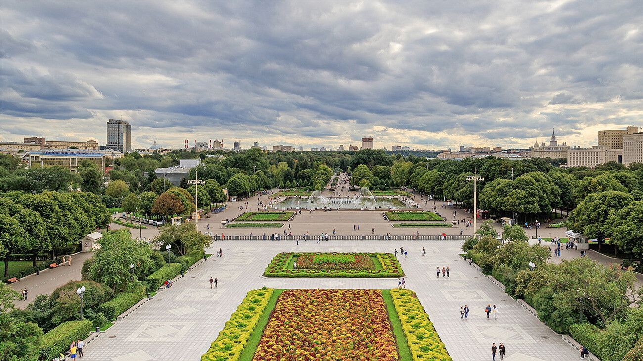
## Description Gorky Park is one of Moscow’s most recognizable public spaces, but its importance goes beyond fame. It functions as a major urban park, a leisure destination, and a symbol of how Moscow’s public life has evolved over time. For visitors, it offers a broad, flexible experience that can include walking paths, riverside views, outdoor activities, cultural programming, seasonal events, and simply the pleasure of being in a lively city park with enough scale to feel substantial. It is a park that can fill a few hours without demanding a rigid plan. One of the reasons Gorky Park remains so appealing is that it balances energy and openness. It is popular with residents, but it still gives travelers space to breathe. A lesser-known fact is that the park has been reinterpreted several times across different periods of Russian history, which means its identity reflects changing ideas about public recreation and city life. Another detail many visitors notice only after arriving is how different the park can feel depending on the season: summer brings crowds, bikes, and long evenings outdoors, while winter can transform parts of the park into a much quieter and more atmospheric space. The park’s value for tourists lies in its versatility. You can come here for exercise, a casual walk, coffee, a river view, or a break from heavy sightseeing. You can also use it as a transition point between more formal cultural landmarks and more relaxed urban exploration. In a city as large as Moscow, that role matters. Gorky Park offers a kind of public relief, a place where the scale softens and the city becomes easier to inhabit on foot. It is also a good example of how a park can be both local and iconic. Residents use it as everyday space, while travelers see it as an essential Moscow destination. That overlap is usually a sign of a worthwhile attraction. ## Location Gorky Park is located in central Moscow, Russia, along the Moskva River. Its riverfront position gives it a scenic edge and makes it easy to combine with surrounding cultural sites or waterfront walks. The park is very much part of the city’s main urban fabric, so it is convenient to reach even if you are staying in a busy central district. The easiest way to get there is by Moscow Metro, followed by a short walk depending on which entrance or section you want to use. Public transport is usually the smartest approach because it avoids traffic and places you directly within the park’s broader central network. Once inside, the grounds are meant to be explored on foot, by bike, or by simply moving from one area to another at your own pace. Because Gorky Park is so flexible, the best plan is often to use it as part of a longer city day rather than as a standalone objective. It pairs naturally with museum visits, riverfront exploration, or a relaxed afternoon in central Moscow. ## Tips Choose the season carefully if you can. Gorky Park changes dramatically across the year, and each season creates a different mood. Leave room for wandering. The park is best when you allow yourself to drift rather than trying to cover every section. Bring a bike or rent one if you want to cover more ground and experience the park like a local. If you are there in warm weather, plan for food and drinks so you can stay longer and enjoy the river atmosphere. Check for events or temporary installations, since the park often has more happening than a first-time visitor may expect. ## Conclusion Gorky Park is one of Moscow’s most adaptable and enjoyable public spaces, combining relaxation, scenery, and urban life in one central location. It is an essential stop for visitors who want to see how Muscovites use the city for leisure. ## FAQ ### Is Gorky Park worth visiting in winter? Yes. The atmosphere changes, but winter can be especially beautiful and calm. ### How long should I spend there? At least 1 to 3 hours, depending on whether you are walking, biking, or attending an event. ### Is it family-friendly? Very much so. The park is a major public leisure space with broad appeal. ### Can I combine it with other Moscow sights? Yes. Its central location makes it easy to pair with museums, river views, or other city-center attractions. ## Links - [Gorky Park](https://russiable.com/gorky-park-moscow/)
GemVoyage Team • World
Tokyo
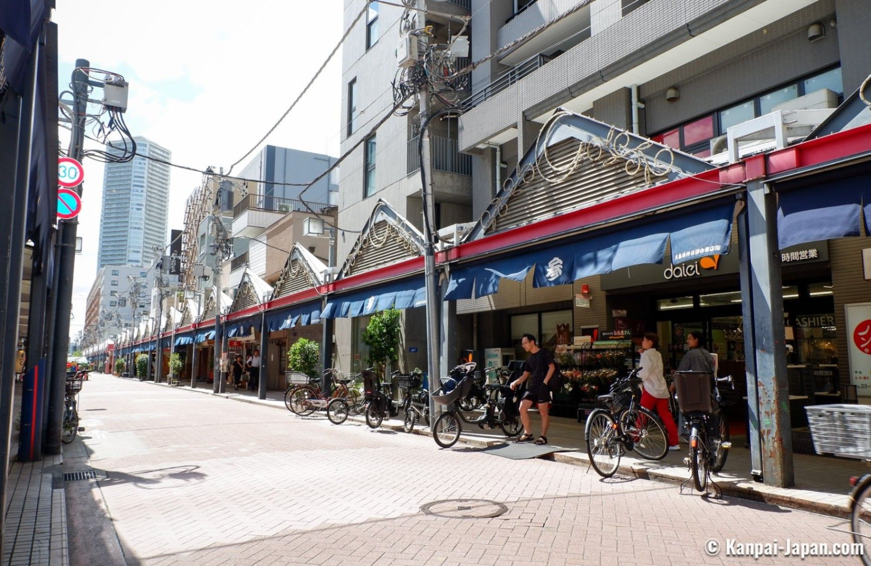
## Description Tsukishima Monja Street, known in Japanese as 月島もんじゃストリート, is one of Tokyo’s most distinctive and food-focused streets, celebrated as the birthplace and spiritual home of monjayaki. Stretching for several hundred meters and lined with dozens of specialized restaurants, the street offers an immersive culinary experience centered on this savory, pan-cooked dish that is especially popular in Tokyo’s downtown areas. Visiting Tsukishima Monja Street is not just about eating; it is about participating in a local tradition that brings people together around the grill. What makes Tsukishima Monja Street unique is the sheer concentration of monjayaki restaurants, many of which have been operating for generations. Each establishment offers its own variations, secret sauces, and ingredient combinations, ranging from classic cabbage and seafood to more modern versions with cheese or spicy flavors. A little-known fact is that Tsukishima developed rapidly after the Great Kanto Earthquake of 1923, and monjayaki became popular as an affordable, filling meal during reconstruction. Another lesser-known detail is that some restaurants still use original family recipes passed down since the early Shōwa period, preserving flavors that have largely disappeared elsewhere in Tokyo. The lively atmosphere, sizzling grills, and nostalgic touches make Tsukishima Monja Street a must-visit for food lovers seeking an authentic Tokyo experience. ## Location Tsukishima Monja Street is located in **Japan**, in the **Tokyo Metropolis**, within the **Chūō Ward** of **Tokyo**. The street runs near Tsukishima Station, close to the Sumida River and Tokyo Bay area. Getting there is easy using public transportation. Visitors can take the Tokyo Metro Yurakucho Line or the Toei Oedo Line to **Tsukishima Station**. From Exit 7, Monja Street is just a short walk away. The area is also accessible by bus or on foot from nearby neighborhoods such as Kachidoki. Due to limited parking, public transport is strongly recommended. ## Tips * Visit in the evening when the street is most lively and the restaurants are fully open. * If you have never tried monjayaki before, choose a restaurant where staff will help cook or explain the process. * Expect casual seating and shared grills; monjayaki is a social dining experience. * Bring cash, as some smaller restaurants may not accept credit cards. * Be prepared for queues during weekends and holidays, especially at well-known restaurants. * Avoid wearing clothes that easily absorb smells, as the cooking process produces strong aromas. ## Conclusion Tsukishima Monja Street offers a flavorful and cultural journey into one of Tokyo’s most beloved local dishes. With its rich history, welcoming atmosphere, and endless variations of monjayaki, it stands out as a unique culinary destination that captures the spirit of old-town Tokyo. ## FAQ **What is monjayaki?** Monjayaki is a savory Japanese dish similar to okonomiyaki but with a runnier batter, cooked directly on a hot griddle at the table. **Do I need to speak Japanese to visit Monja Street?** No, many restaurants are used to tourists, and some offer English menus or visual guides. **How much does a typical meal cost?** Most monjayaki dishes are reasonably priced, typically ranging from moderate to affordable compared to other Tokyo dining areas. **Is Tsukishima Monja Street family-friendly?** Yes, families are welcome, though supervision is needed around the hot grills. **Can I visit during the daytime?** Yes, some restaurants open for lunch, but the street is more vibrant in the evening. ## Links * [Tsukishima Monja Street Official Website](https://www.gotokyo.org/en/spot/85/index.html)
GemVoyage Team • World
Lisbon
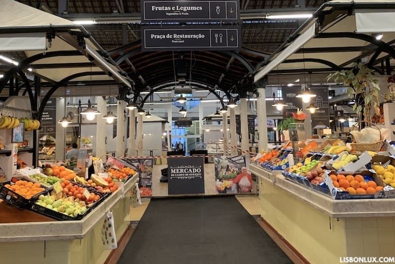
## Description Mercado de Campo de Ourique is a lively neighborhood market in Lisbon that blends traditional market stalls with contemporary food vendors, offering an authentic cross-section of Portuguese culinary life. The market serves locals with fresh produce, fish, meat and pantry items, while an inner food-hall atmosphere provides ready-to-eat dishes, pastries and coffee. What sets Campo de Ourique apart is its local, residential character — it’s not just a tourist attraction but a functioning community hub where Lisbon residents shop and socialize. The market’s architecture is typically covered and airy, with stalls organized around central aisles. Recent renovations have injected a modern food-court vibe alongside still-active traditional vendors, making it a place where you can buy grocery staples in the morning and return later for a relaxed meal. Little-known facts: Campo de Ourique historically developed as a self-contained neighborhood with a strong shopping tradition, and the market has long been a point where multiple culinary generations intersect. ## Location Mercado de Campo de Ourique sits in the Campo de Ourique neighborhood in Lisbon, Portugal, in the western part of central Lisbon near the Estrela and Rato districts. The neighborhood is primarily residential with shops, bakeries and small restaurants lining the streets. Getting there: The neighborhood is accessible by tram, bus and metro. The Rato Metro station and several bus lines serve the area; trams and short walks from nearby attractions make it easy to combine a market visit with broader neighborhood exploration. Taxis and rideshares can drop you near the market’s main entrance. ## Tips - Best times: Morning is ideal for shopping fresh produce and avoiding lunch crowds; midday is excellent for sampling prepared dishes. - What to try: Don’t miss fresh pastries, Portuguese cheeses, cured meats and regional specialties. Many stalls offer ready-to-eat plates — ask vendors for local recommendations. - Payment: Vendors accept cards and cash; small stalls may prefer cash for tiny purchases. - Local etiquette: Bring a reusable bag for purchases; be polite in queues and avoid blocking aisles when tasting or photographing. - Combine visits: Explore nearby bakeries and cafés in Campo de Ourique for a fuller neighborhood taste. ## Conclusion Mercado de Campo de Ourique offers a warm, authentic Lisbon market experience where traditional shopping and contemporary food culture coexist. It’s perfect for visitors seeking genuine neighborhood life, excellent local food and the chance to taste Portuguese everyday cuisine alongside longtime market traditions. ## FAQ Q: Is the market touristy? A: It retains a strong local clientele, though visitors are welcome and many stalls cater to diverse tastes. Q: Are there vegetarian options? A: Yes. Many vendors and food stalls offer vegetarian and vegan-friendly dishes. Q: Can I take food to go? A: Absolutely; many stalls prepare takeaway plates and sandwiches. Q: Is parking available nearby? A: Street parking and small public car parks exist, but public transport is recommended. ## Links [Lisbon Travel Guide](https://www.visitlisboa.com/en)
GemVoyage Team • World
Cologne
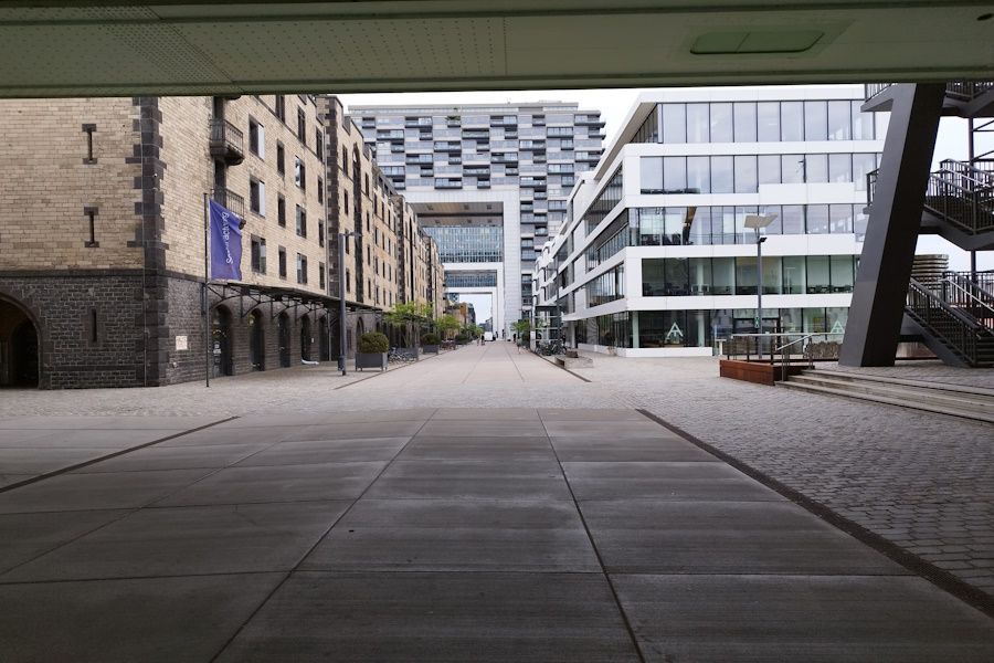
## Description The Rheinauhafen District in Cologne exemplifies thoughtful urban redevelopment: a former industrial harbor reimagined as a walkable district of offices, housing, restaurants, and public promenades. Its most striking architectural features are the crane houses (Kranhäuser), modern structures that reference the port's past while creating a distinctive skyline along the Rhine. The district combines strong visual identity with accessible public space, making it an appealing stop for visitors and locals alike. What makes Rheinauhafen particularly interesting is its balance of design ambition and pragmatic public access. The promenades invite walking and cycling; riverside cafés and small parks encourage lingering; and the architecture rewards both appreciation and photography. The transformation of the former harbor area into a mixed-use neighborhood has become one of Cologne's most visible examples of urban regeneration, and the district sits comfortably alongside the city's historic core. ## Location Rheinauhafen lies along the Rhine south of Cologne's Old Town, a short walk from key central attractions. It is well connected by tram, bus, and pedestrian routes, allowing easy integration into walking tours that include the cathedral, museums, and the Old Town. The district's linear layout along the river makes it particularly suited to a riverside walk that can be shortened or extended depending on your schedule. Because Rheinauhafen is adjacent to major city sights, it functions well as an extension of a cultural itinerary—grab coffee or lunch here after a museum visit, or plan an evening walk to see the waterfront at sunset. ## Tips - Explore on foot to appreciate perspectives from both the promenade and the opposite bank of the Rhine. - Bring a camera for architectural details and reflections on the river surface—sunset light is especially flattering. - Combine the visit with nearby Old Town attractions, museums, or a Rhine river cruise for variety. - Stop at a riverside café or bistro to turn a quick photo stop into a leisurely break. - If cycling, use the well-maintained paths but be mindful of pedestrians along popular stretches. - Check events calendars: the promenade sometimes hosts markets or cultural events that enrich a visit. ## Conclusion Rheinauhafen is a model of how contemporary design can coexist with historic city fabric. It is a polished, open, and welcoming district that rewards unhurried exploration and flexible itineraries—whether you come for architecture, a riverside walk, or a relaxed café stop. ## FAQ ### What is Rheinauhafen known for? It is best known for its crane houses and the successful transformation of a former industrial harbor into a mixed-use, riverfront district. ### Is Rheinauhafen good for walking? Yes—its promenades and river views make it ideal for a comfortable stroll, photography, and small detours into cafés and galleries. ### How long should I spend there? An hour or two is fitting for a leisurely walk and photos; combine it with nearby attractions for a half-day or full-day plan. ### Is it more for locals or tourists? Both. Locals use the promenade for daily walks and dining, while visitors come for architecture and river views; the mix gives the district an authentic feel. ### What should I see nearby? Cologne's Old Town, the cathedral, and riverside museums are all within easy reach and pair well with a Rheinauhafen visit. ## Links - [Wikipedia](https://en.wikipedia.org/wiki/Rheinauhafen)
GemVoyage Team • World

Comments