Discover extraordinary places shared by our community of travelers
Gansu
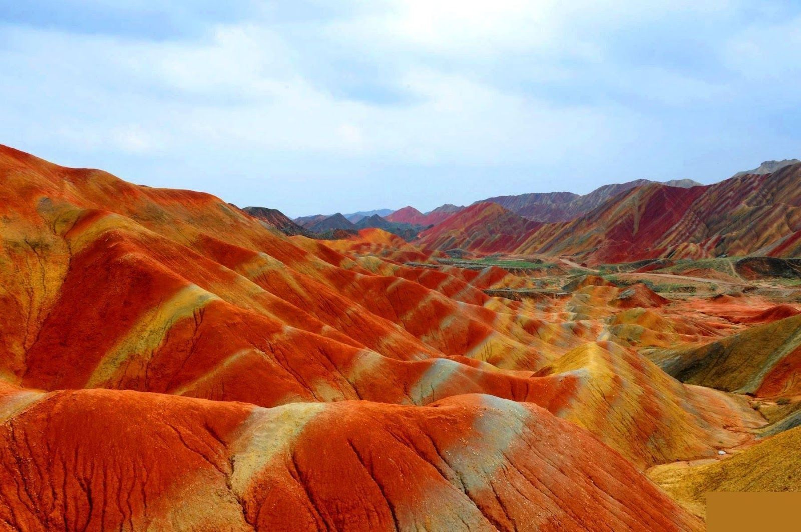
## Description The Zhangye Danxia landform in Gansu province is a riot of color spread across layered sandstone ridges and steep cliffs, creating landscapes that look as if someone painted the earth with broad strokes of red, orange, yellow and green. The chromatic bands are the product of red sandstone and mineral deposits laid down over 24 million years and later uplifted and carved by wind and water. Viewed from purpose-built overlooks and winding boardwalks, the patterns create optical illusions of waves and folds that shift with the sun’s angle. The site is remarkable both for its vivid palette and for the scale of the striations: what from a distance seems like painted canvas resolves into a labyrinth of ridges, gullies and panoramic terraces. A lesser-known detail: the colors vary seasonally and with weather conditions; after rain, the hues often deepen, offering particularly saturated photographic opportunities. Beyond the immediate visual drama, Zhangye Danxia offers a lesson in geologic time and human-scale interpretation of landscape. The park's boardwalks and viewing platforms were designed to give visitors a range of compositions at different elevations, while interpretive signs explain the processes of sedimentation, uplift and erosion that produced the striking bands. Photographers and landscape enthusiasts often plan their visits around atmospheric conditions: low-angle light during golden hours casts ridges into sharp relief, while overcast or misty days can soften colors and emphasize shapes. The park's scale means that a single viewpoint never fully captures the variety present across the terrain — taking time to traverse multiple platforms yields a richer sense of the formations. Local infrastructure has expanded to accommodate steady tourism, but many visitors still find quiet corners along lesser-known paths. For those willing to explore beyond the main viewing decks, short hikes and rural lanes reveal unexpected perspectives of the painted cliffs and provide a quieter atmosphere for contemplative study. The town of Zhangye offers practical amenities including hotels, train connections and guided-tour services; most visitors access the geopark via a short drive from the city. When combined with nearby attractions in Gansu province — historic Silk Road sites, oasis towns and desert landscapes — Zhangye Danxia becomes a vivid and contrasting chapter in any northwest China itinerary. ## Location The Zhangye Danxia Geopark lies in Zhangye city, Gansu province, northwestern China. It’s accessible by road from Zhangye city center, which in turn connects by train or air to larger Chinese hubs such as Lanzhou and Xi’an. The park’s viewing platforms are designed for staged sightseeing, enabling visitors to experience different panoramas without extensive trekking. Timetables for trains and regional buses vary seasonally; many travelers arrive by high-speed or conventional rail to Zhangye and then take local shuttle services or taxis to the geopark entrance. The park's layout is linear, with a series of parking lots and platforms that correspond to different photographic viewpoints — plan logistics to avoid backtracking during peak hours. Accommodation in Zhangye ranges from economical guesthouses to mid-range hotels that can arrange guided excursions and private transport. ## Tips - **Visit at golden hour:** Sunrise or sunset gives the painted ridges warmer tones and dramatic shadows. - **Use multiple viewpoints:** Walk the main boardwalk and visit several overlooks to appreciate how the formations change with perspective. - **Protect from dust and sun:** The region is arid; bring sun protection and a dust cover for camera gear. - **Consider guided photo tours:** Local guides can take you to lesser-known vantage points for unique compositions. - **Time your transport:** Parking and shuttle flows can be busy; arrive early to avoid crowds at the main platforms. - **Dress for desert conditions:** Layered clothing, sturdy shoes and water are essential; evenings can cool significantly. - **Respect park rules:** Stay on boardwalks to protect fragile soils and prevent erosion; drones are often restricted. - **Bring varied lenses:** A wide-angle to capture panoramic ridgelines and a moderate telephoto to isolate patterns will be useful. ## Conclusion Zhangye Danxia offers one of the planet’s most vivid examples of sedimentary color and erosion, a landscape that rewards patient observation and thoughtful composition. Visiting Zhangye Danxia is as much an exercise in perception as it is in travel logistics — the colors and forms change with light, season and vantage point, and the most memorable experiences come when you slow down and let the terrain reveal its subtleties. For photographers, geologists and curious travelers, the geopark is a compelling and photogenic stop that pairs well with broader exploration of Gansu’s cultural and natural history. ## FAQ - **Q: Is the park walkable?** - A: Yes — well-maintained boardwalks and viewing platforms offer accessible scenic routes. - **Q: Can I drive between viewpoints?** - A: Internal park transport and short walks connect main viewpoints; check park maps for distances. - **Q: When is the best season for color saturation?** - A: Late spring through early autumn generally provides strong color contrast, but early morning light and post-rain conditions often produce the most saturated hues. - **Q: Are drones allowed for aerial photography?** - A: Drone policies vary and are often restricted near protected viewpoints — always check park regulations and obtain permits if required. - **Q: How much time should I allocate?** - A: A full half-day can cover the primary platforms; photographers might want a full day to cycle through light conditions and multiple viewpoints. - **Q: What other nearby sites pair well with Zhangye Danxia?** - A: Historic Silk Road towns, the Mati Temple Grottoes and desert landscapes around Zhangye make for complementary cultural and geological explorations. ## Links - [Zhangye Danxia — Wikipedia](https://en.wikipedia.org/wiki/Zhangye_National_Geopark)
GemVoyage Team • World
Seoul
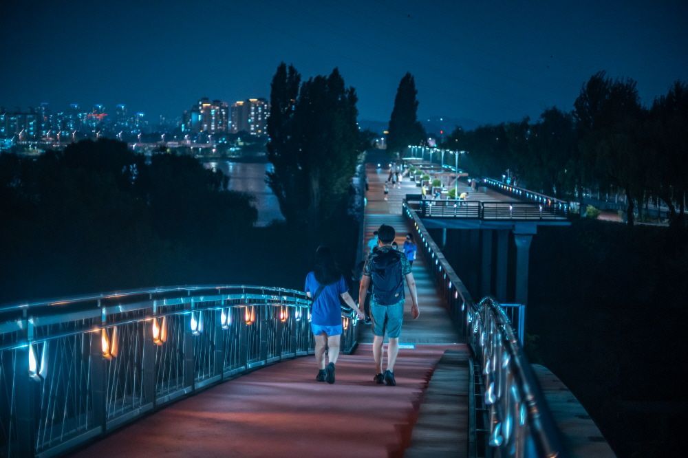
## Description Seonyudo Park is a standout example of urban ecological design: a former water treatment plant reborn as a thoughtfully landscaped public park on an island in the Han River. The designers preserved key elements of the plant—filter basins, machinery platforms, and concrete shells—and repurposed them as botanical displays, reflective ponds and educational spaces. The result is a layered experience where industrial memory and living ecology intersect: walking routes weave through restored filtration beds, shaded groves, themed gardens and interpretive exhibits that explain water purification and habitat restoration. Visitors appreciate Seonyudo for its inviting balance of engineered structure and natural regeneration. The greenhouse and wetland areas host seasonal plantings and migratory birds, while the decks and viewpoints offer long riverside panoramas that are particularly striking at sunset. Beyond the visual appeal, the park operates as a civic classroom: plaques and small exhibits outline the former plant operations and current sustainability initiatives, helping visitors of all ages understand ecological cycles and urban water systems. Seonyudo’s design also makes it a pleasant social space: picnic spots, quiet courtyards and accessible pathways encourage lingering, and occasional cultural events—workshops, guided ecological walks and small performances—lend the park a local community feel. For urban planners, photographers and families alike, Seonyudo Park is a model of how industrial remnants can be transformed into resilient public amenities. ## Location Seonyudo Park sits on Seonyudo Island in the Han River within Mapo-gu, central Seoul. The island is easy to reach by the pedestrian footbridge connecting to the northern riverbank near Dangsan, and public transit options include Seonyudo Station (Line 9) and nearby bus stops. Cyclists frequently access the island via the riverside cycling paths that thread along the Han. Because Seonyudo is integrated into the riverfront network, you can combine a visit with a longer riverside ride or walk that links to adjacent parks and cultural districts. The park’s central location makes it an accessible stop during a day exploring Mapo and the west bank of the Han. ## Tips - Go in late afternoon or early evening for the best light and cooler temperatures, especially in summer. - Rent or bring a bicycle to follow the riverside paths; Seonyudo is well connected to Seoul’s cycling routes. - Take the short interpretive walk through the former filter beds to learn about the site’s history and water treatment processes—signage and occasional guided tours add context. - Pack a picnic or a light snack; while there are small kiosks at times, facilities are limited compared with larger parks. - Watch for seasonal plantings and bird migrations—spring and autumn are especially rewarding for flora and fauna observation. ## Conclusion Seonyudo Park exemplifies how thoughtful design can convert industrial infrastructure into productive green space. It rewards visitors who are curious about urban sustainability, landscape architecture and the layered histories of cities. Whether you are a photographer seeking unique compositions of water and concrete, a family looking for a quiet riverside escape, or a planner studying adaptive reuse, Seonyudo offers a memorable, instructive and restful visit. ## FAQ Q: Is there an entrance fee? A: No. Seonyudo Park is a public park and free to enter, though some seasonal programs or guided workshops may have small fees. Q: Are dogs allowed in the park? A: Dogs are generally allowed but must be kept on a leash and under control; check posted rules for specific zone restrictions. Q: Are there restroom facilities and drinking water? A: Public restrooms and water fountains are available near principal access points, but facilities can be limited—carry water for long summer visits. Q: Can I cycle across the park? A: Cycling routes approach and circle the island; on-site cycling may be restricted in certain pedestrian or ecological zones—dismount where indicated. Q: Is there parking nearby? A: Limited parking is available along nearby roads, but public transit and cycling routes are the preferred ways to reach the island. ## Links - [Seonyudo Park (Wikipedia)](https://en.wikipedia.org/wiki/Seonyudo_Park)
GemVoyage Team • World
Seoul
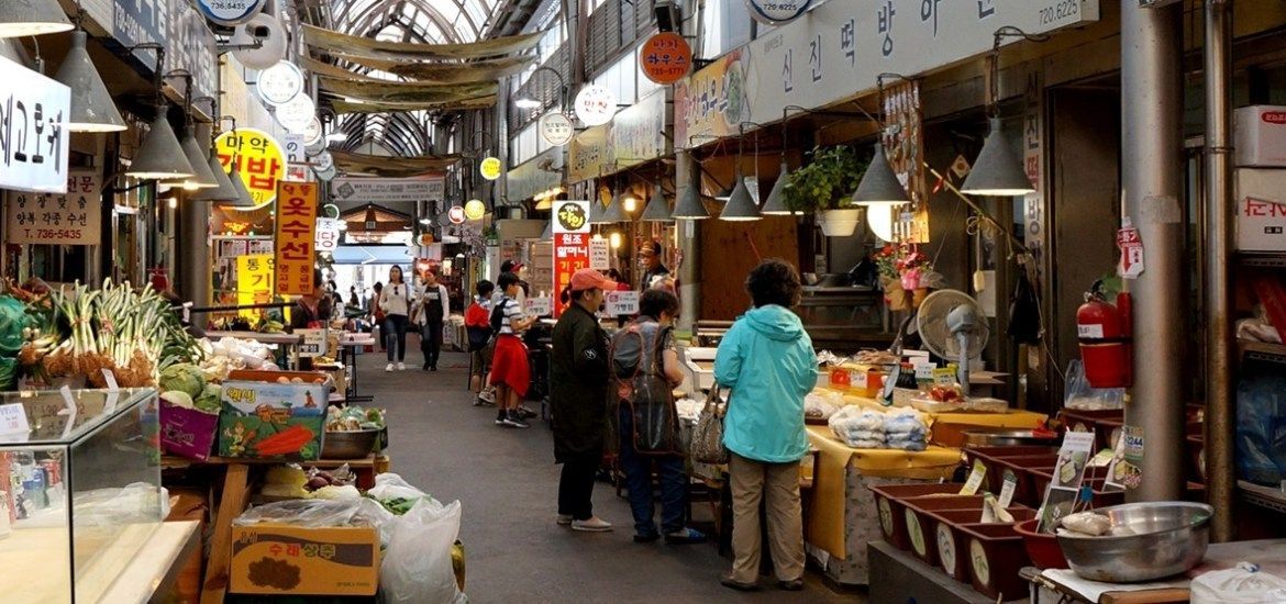
## Description Tongin Market is a compact, characterful market in central Seoul famous for its Dosirak Café, a hands-on lunch experience where visitors exchange tokens for small plates to fill a personalized lunchbox (dosirak). The market’s atmosphere is lively and local: stalls sell banchan, grilled fish and meats, fresh kimchi and seasonal produce, while small indoor counters offer soups and comforting home-style dishes. Tongin’s post-war history as a community trade hub gives the market an intimate, neighborhood feel, and several long-running family stalls preserve recipes passed down through generations. The Dosirak Café system is the market’s signature: buy a set number of tokens, trade them for small portions at participating stalls, and assemble a mixed meal that showcases different flavors and textures. This approach encourages sampling, conversation and culinary discovery—perfect for visitors who want to taste many dishes without committing to a single restaurant. Tongin’s vendors balance straightforward comfort food with subtle house specialties, and the market’s layout makes it easy to move from stall to stall, spotting unique snacks and regional ingredients along the way. Beyond the food, Tongin sits within a culturally rich neighborhood near Gyeongbokgung Palace and Seochon, which rewards pairing the market visit with historic sightseeing and gallery strolls. The market’s scale and accessibility make it ideal for solo travelers, couples and families looking for an authentic taste of Seoul’s food traditions. ## Location Tongin Market is located in Jongno-gu in central Seoul, a short walk from Gyeongbokgung Palace and within the Seochon neighborhood. The closest subway stop is Gyeongbokgung (Line 3), and it’s a 10–15 minute walk through interesting historic streets. Buses and taxis are plentiful in this central district, and the market is easily combined with a morning of palace visits and nearby galleries and cafes. Because Tongin is centrally located, it makes a convenient stop on a cultural day itinerary: visit the palace, stroll Seochon’s alleyways, then refuel at the market with a token-driven dosirak or a hot bowl of jjigae at a neighborhood eatery. ## Tips - Arrive early, especially on weekends—popular stalls can develop short lines during midday. - Buy dosirak tokens at the market office and pace your token use so you can sample a variety of stalls. - Ask vendors what’s house-made and seasonal; small stalls often serve regional banchan and specialties not found elsewhere. - Carry modest cash; many vendors accept cards, but tokens and small cash payments remain the norm. - Be mindful of shared seating etiquette: food is communal and stalls expect quick, polite turnover during busy periods. ## Conclusion Tongin Market captures the social and culinary warmth of Seoul’s neighborhood markets. The Dosirak Café system turns dining into an exploratory game of tastes, and the market overall rewards curiosity and good manners. For travelers who want to eat like a local, sample many dishes and experience genuine hospitality, Tongin remains a memorable, portable culinary experience. ## FAQ Q: How do I use the Dosirak Café? A: Buy your tokens at the market office, then present tokens to participating stalls in exchange for small portions. Keep tokens until you’ve built your preferred dosirak, then find shared seating to enjoy your selection. Q: Can visitors with dietary restrictions find options? A: Yes—vegetarian and pescatarian choices are common (many banchan are vegetable-based). For strict allergies or vegan diets, ask vendors about ingredients and preparation to avoid hidden animal products. Q: Is the market wheelchair accessible? A: Accessibility varies across older market alleys; main approaches are walkable but some stalls and passages have steps—contact local tourist information for help planning an accessible route. Q: Are there English menus or signage? A: English is limited but many vendors use photographs or display dishes. A translation app, pointing to items or asking staff at the token office can help. ## Links - [Tongin Market (Wikipedia)](https://en.wikipedia.org/wiki/Tongin_Market)
GemVoyage Team • World
Dubysa
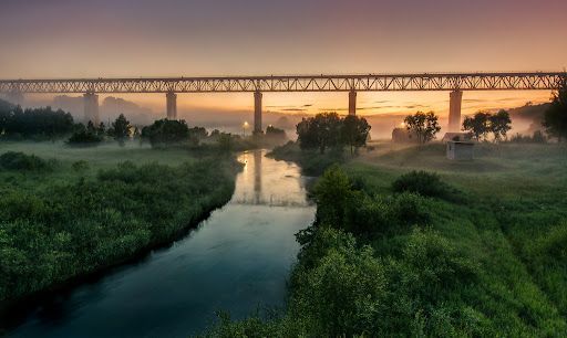
## Description Lyduvėnai Bridge is an arresting piece of nineteenth- and twentieth-century engineering that spans the deep, wooded Dubysa River valley near Lyduvėnai. Its soaring iron arches and lattice work combine functional railway engineering with a sculptural presence that is particularly striking when framed by the steep gorge below. Photographers, history enthusiasts and hikers are drawn to the site for the dramatic perspectives it creates—an industrial monument suspended over a wild, verdant canyon. Over time the bridge has required restorations and careful maintenance, and those interventions are part of its layered history. Local preservation efforts have sought to keep the bridge operational while respecting its historical materials and structure. The engineered spans and riveted ironwork tell a story about rail transport, regional development and the craft of steel construction. Beyond its technical merits, Lyduvėnai Bridge sits within a landscape of trails, viewpoints and small rural roads that allow visitors to explore the canyon from multiple angles. Birdsong and river sounds contrast with the bridge’s metallic lines, and seasonal changes—spring greens, autumn foliage—transform the setting dramatically, offering different moods for photographic study. ## Location Lyduvėnai Bridge is located near the village of Lyduvėnai in Raseiniai district municipality, Kaunas County, central-western Lithuania. It spans the Dubysa River in a steep, forested valley that is characteristic of the region’s mixed agricultural and wooded landscape. Access is most convenient by car: follow regional roads from Raseiniai and nearby towns. Public transport to the immediate vicinity is limited, so visitors relying on buses or trains should plan for a taxi or private transfer for the final leg. The rural setting rewards a slower pace—park at designated pullouts or village car parks and follow marked trails toward viewpoints. ## Tips - Photograph at golden hour—early morning or late afternoon—when light sculpts the ironwork and the valley takes on warm tones. - Never walk on active tracks; use official viewpoints and trails to keep a safe distance while still getting dramatic compositions. - Bring sturdy shoes and insect repellant for nearby trails; the area can be steep and overgrown in parts. - Combine the visit with local villages, riverside hikes and birdwatching; pack water and snacks as amenities are sparse. - Check local guidance on accessibility—some viewpoints require steep walks, while others are more level and family-friendly. ## Conclusion Lyduvėnai Bridge is an exemplar of how engineering and landscape can produce a site of compelling beauty. The bridge rewards visitors who slow down to observe structural detail, changing light and the interplay of human craft with natural settings. Whether you come for history, photography or a quiet day outdoors, the bridge and its surrounding valley offer memorable vistas and a distinct slice of regional heritage. ## FAQ Q: Can visitors walk across the bridge? A: No. For safety and legal reasons, do not walk on active railway tracks. Use the designated viewpoints and trails which provide safe vantage points. Q: Is the bridge accessible by car? A: Yes, but roads are rural and sometimes narrow—drive carefully and park only in designated areas or official pullouts. Q: Are there guided tours or information panels on site? A: Information is limited on-site; local heritage groups sometimes publish guides or online materials—check regional tourism resources for up-to-date information. Q: What wildlife might I see in the Dubysa valley? A: The valley supports woodland birds, small mammals and a range of plant life; spring and autumn are best for birdwatching and seasonal flora. Q: Is it possible to photograph the bridge from below? A: Some viewpoints near the riverside allow lower-angle shots, but access may be steep and require caution; respect private property and posted restrictions. ## Links - [Lyduvėnai Bridge](https://militaryheritagetourism.info/en/military/sites/view/800)
GemVoyage Team • World