GemVoyage Team • World
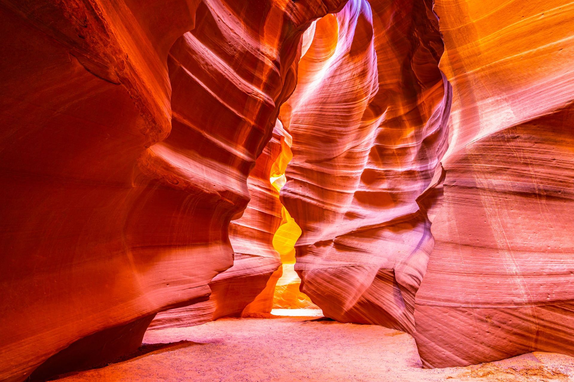
Antelope Canyon’s combination of geological finesse and cultural sensitivity makes it unique: it’s on Navajo Nation land and visits occur under Navajo guides who share cultural context and ensure conservation. The ephemeral quality of light in the canyon is the main draw, and every visit offers a subtly different visual story depending on time of day and season.
Visiting Antelope Canyon is an intimate, often crowded experience that rewards patience and close observation. The sculpted walls are tactile and close, and the sense of enclosure makes small variations in light and dust dramatically affect composition. Guides routinely manage group flows and timing to optimize safety and photographic opportunity, and many operators now offer specialized photo tours that allow extra time or more flexible tripod policies. Safety is a constant priority — because slot canyons channel water, flash floods are a real hazard and tours may be altered or canceled in the face of storm risk. Respect for Navajo cultural protocols is also essential: guides often include stories and historical context that enrich a visit and reinforce why access is managed.
Beyond the two main canyons, nearby attractions around Page — Horseshoe Bend, Lake Powell and Glen Canyon National Recreation Area — make the area a compact cluster of dramatic southwestern landscapes. Combining these sites into a short itinerary can balance the compressed, processed light of the slot canyons with broad, open panoramas of the Colorado River and surrounding desert.
Most tours meet in Page; travel to the canyon involves a short drive and, in some cases, a brief ride across Navajo lands to the canyon entrance. Tour operators coordinate closely with park officials and Navajo authorities; book in advance during peak seasons and confirm pickup details. Page has several accommodation options, from campgrounds to hotels, and is a good base for multi-day exploration of the region.
Approach Antelope Canyon with curiosity and respect, and you’ll come away with a visceral appreciation for how water, time and human stewardship intersect. For photographers, the canyon is a study in subtle gradients and form; for travelers, it’s an opportunity to learn about the cultural landscape of the Navajo Nation while witnessing an extraordinary geological gallery.
Discover more hidden gems you might love.
Varėna
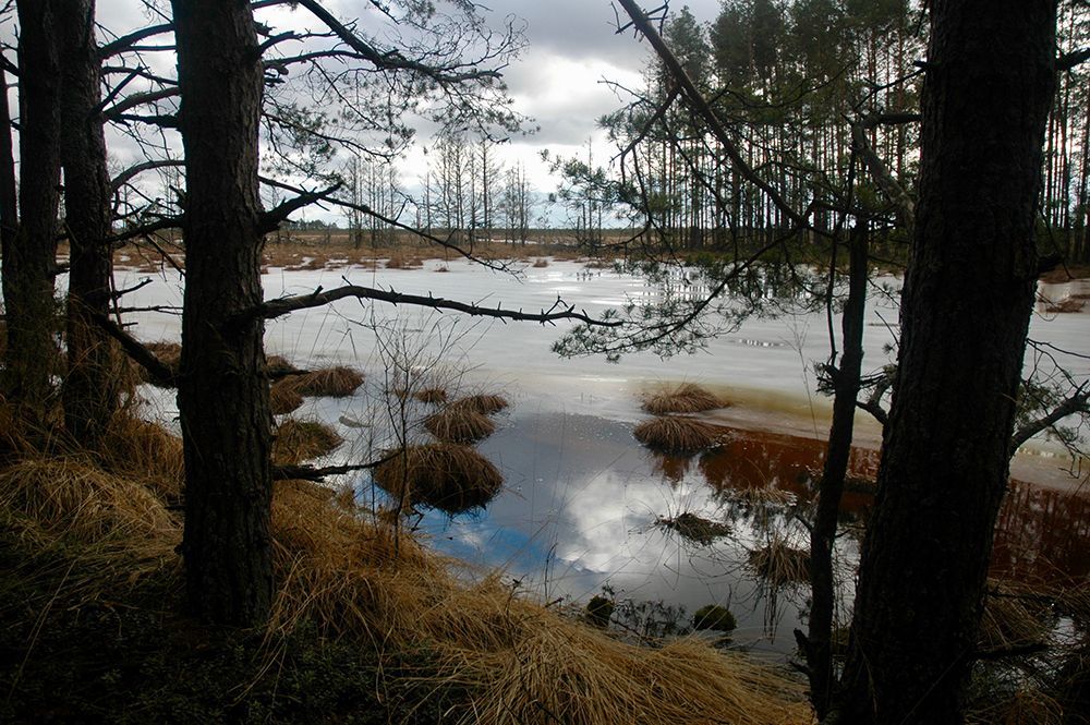
## Description Čepkeliai Raised Bog is among Lithuania’s most important peatland reserves, an expansive raised bog that feels at once remote and intimate. Its surface is a subtle patchwork of sphagnum hummocks, shallow pools, and scattered stunted pines; that patterning creates a fragile, otherworldly landscape that changes color and mood with the light. For naturalists and quiet travelers the bog offers a concentration of specialized habitats where rare mosses, sedges, and lichens flourish alongside insect life and bird species adapted to waterlogged peat. Beyond its visible beauty, Čepkeliai is scientifically invaluable. The peat layers here have accumulated over millennia, trapping pollen, seeds, and macrofossils that give researchers a continuous record of past vegetation and climate. That archive helps reconstruct regional environmental history and informs conservation decisions today. The bog’s intact hydrology—its network of raised surfaces and water-filled hollows—supports unique ecological processes, from specialized plant communities to breeding cycles for rare birds. Although the terrain looks invitingly wild, it’s also extremely fragile. Walking off designated paths can crush sphagnum carpets and disturb microhabitats that take decades to recover. To balance access with protection, visitation in Čepkeliai is carefully managed: boardwalks, observation platforms, and tightly controlled trails concentrate human presence on durable surfaces and minimize harm. This measured approach preserves the bog’s ecological integrity while still allowing people to experience its unusual beauty and quiet drama. For photographers, botanists, and birdwatchers the bog offers intimate encounters with species and textures rarely seen outside specialized reserves. In spring and summer, sunlit pools mirror cloudscapes and dragonflies patrol the grassy margins. Autumn brings a palette of muted reds, golds, and moss greens; winter covers the place in a hush of snow and ice that highlights the bog’s sculptural shapes. Guided walks—often led by local naturalists—are invaluable for understanding the subtle signs of bog life and the reasons for strict protection. ## Location Čepkeliai Bog is located in southern Lithuania, near the town of Varėna in Alytus County, within the larger Dzūkija region. It sits in a sparsely populated, forested landscape that reinforces the sense of remoteness. The reserve forms part of Lithuania’s system of protected areas and is managed to conserve both its natural features and the scientific information contained within its peat layers. How to get there: the most practical route for independent travelers is to drive from Varėna, following local roads into the reserve’s access points. Some conservation organizations and local guides run organized excursions from Varėna and nearby towns; these are often the best option if you don’t have a car. Public transport options are limited and may require additional local transfers and walking; if you rely on buses, plan carefully and allow extra time. In many cases, visiting with an experienced guide not only eases logistics but also improves the interpretive experience—guides can point out rare species and explain the bog’s geological story. ## Tips - Stay on boardwalks, platforms, and marked trails—stepping onto soft peat damages the vegetation and disrupts hydrology. - Wear waterproof, sturdy footwear; some approaches are muddy even in summer, and the boardwalks can be damp. - Bring binoculars and a field guide (plants, birds, insects) to make the most of wildlife spotting opportunities. - Visit in the early morning or late afternoon for the best light and more active bird life; midday can be quieter for wildlife. - Book guided walks where available—local guides provide historical and ecological context and reduce your impact. - Respect seasonal closures and nesting zones; some areas close during bird breeding seasons to protect sensitive species. - Travel light and pack out any litter; even biodegradable waste can alter nutrient cycles in peat ecosystems. ## Conclusion Čepkeliai Raised Bog rewards visitors who slow down and look closely. It is a living archive and sanctuary where the physical landscape—peat layers, patterned pools, and sphagnum carpets—holds stories of centuries of changing vegetation and climate. Visiting responsibly, on boardwalks and under guidance, reveals a quiet world of specialized life and an ecological history that connects modern conservation to deep time. ## FAQ Q: Can I walk freely in the bog? A: No. To protect delicate peat and the species that depend on it, walking is restricted to boardwalks and designated trails. Off-trail access is prohibited in many areas. Q: Are guided tours available? A: Yes. Organized guided nature walks are often offered by conservation groups or local guides; they improve the experience and reduce ecological impact. Q: When is the best time to visit for wildlife viewing? A: Spring and early summer are excellent for bird activity and insect life; early morning and late afternoon offer better sightings and softer light for photography. Q: Is the bog safe for solo visitors? A: The area is generally safe, but the remoteness and fragile terrain mean solo visits are best for experienced, well-prepared hikers; joining a guided walk is recommended for most visitors. Q: Can I take photographs or drones in the reserve? A: Photography from boardwalks and platforms is usually permitted; drones are commonly restricted to prevent disturbance—check reserve rules in advance. Q: Are there facilities nearby? A: Facilities are limited; plan for basic needs (water, layers, footwear) and expect minimal infrastructure near the main access points. ## Links - [Čepkeliai (Wikipedia)](https://en.wikipedia.org/wiki/%C4%8Cepkeliai)
GemVoyage Team • World
Aswan
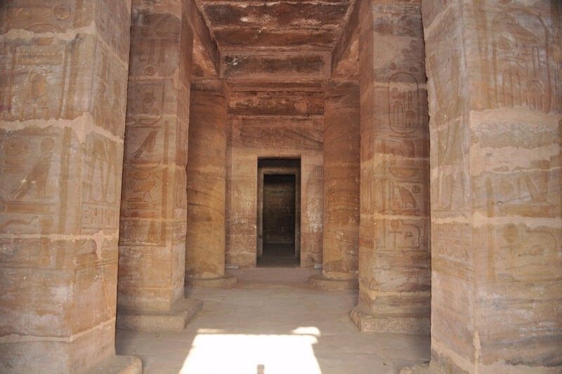
## Description **The Temple of Amada** is one of the oldest surviving stone temples in Nubia and a remarkable example of **New Kingdom Egyptian architecture** outside the Nile Valley’s main centers. Built during the reigns of **Thutmose III** and **Amenhotep II** in the 18th Dynasty (15th century BCE), the temple was dedicated to the gods **Amun-Re** and **Re-Horakhty**. While modest in size compared to the great temples of Luxor, Amada’s historical and artistic value is exceptionally high. What makes the Temple of Amada unique is its **well-preserved interior inscriptions**. The walls are covered with detailed reliefs and hieroglyphic texts that document military campaigns in Nubia and the Near East. One inscription records a victory so overwhelming that it claims the stench of defeated enemies filled the land—an unusually vivid and rare narrative detail in Egyptian temple texts. A lesser-known but crucial fact is that the temple originally stood several kilometers south of its current location. During the 1960s, it was **relocated intact** as part of UNESCO’s Nubian Monuments rescue campaign, launched to save ancient sites threatened by flooding from the construction of the Aswan High Dam. Unlike Abu Simbel, which was cut into blocks, the Temple of Amada was moved as a **single structure**, an extraordinary engineering achievement that preserved its fragile wall paintings. The temple’s proportions are elegant and restrained, with a small pylon, open courtyard, hypostyle hall, and sanctuary. Its compact scale allows visitors to closely study reliefs and inscriptions without the overwhelming crowds found at larger sites, making it especially rewarding for those interested in Egyptian history and epigraphy. ## Location **Country:** Egypt **Region:** Upper Egypt / Nubia **Nearest City:** Aswan The Temple of Amada is located approximately **20 kilometers south of Aswan**, near Lake Nasser, close to the modern village of New Amada. ### How to Get There * **By guided tour:** * Most visitors reach Amada as part of a **Lake Nasser archaeological tour**, either by road or boat. * **By car:** * Accessible via the Aswan–Abu Simbel road, though permits may be required for independent travel. * **By cruise boat:** * Some Lake Nasser cruises include Amada as a scheduled stop. ## Tips * **Visit with a guide:** The inscriptions are historically rich but easy to miss without explanation. * **Allow time inside:** The temple’s value lies primarily in its interior reliefs, not its exterior. * **Bring sun protection:** The site is exposed, and shade is limited. * **Photography is allowed:** Flash should be avoided to protect the wall paintings. * **Combine with nearby sites:** The temples of Derr and the Tomb of Pennut are often visited together. * **Best visited in winter:** Cooler temperatures make exploration far more comfortable. ## Conclusion The Temple of Amada is a quiet but powerful witness to Egypt’s imperial presence in Nubia. Its vivid inscriptions, elegant design, and dramatic modern relocation make it one of the most historically important yet underrated ancient temples in southern Egypt. ## FAQ **1. When was the Temple of Amada built?** It dates to the 18th Dynasty, primarily during the reigns of Thutmose III and Amenhotep II. **2. Why was the temple moved?** It was relocated to prevent flooding caused by the creation of Lake Nasser after the Aswan High Dam. **3. Is the temple original or reconstructed?** It is original; the entire structure was moved intact rather than rebuilt from blocks. **4. How long does a visit take?** Approximately **30–60 minutes**, depending on interest in inscriptions. **5. Is it crowded?** No. It is much quieter than major temples along the Nile. **6. Is the site suitable for casual visitors?** Yes, though history enthusiasts will appreciate it the most. ## Links * [Egypt tourism portal](https://www.experienceegypt.eg/en)
GemVoyage Team • World

Copenhagen
## Description The Hans Christian Andersen Experience in Copenhagen is a cultural attraction dedicated to one of Denmark’s most famous figures and one of the world’s most influential storytellers. Rather than functioning as a traditional museum, the experience is designed as an immersive walk-through journey that brings Andersen’s life and fairy tales to life through sets, soundscapes, projections, and storytelling elements. Visitors are invited to step directly into the imaginative universe behind timeless stories such as *The Little Mermaid*, *The Ugly Duckling*, and *The Emperor’s New Clothes*. What makes the Hans Christian Andersen Experience unique is its narrative-driven design. Instead of focusing heavily on historical artifacts, the attraction emphasizes emotion, atmosphere, and imagination, mirroring the way Andersen himself told stories. Visitors move through scenes inspired by both his personal life and his fictional worlds, gaining insight into how his hardships, travels, and observations shaped his writing. A little-known fact is that Andersen struggled with poverty and social insecurity early in his life, themes that quietly echo throughout many of his fairy tales. Another lesser-known detail is that some installations are inspired by Andersen’s own paper cuttings, an art form he practiced privately and which reflects his intricate creative mind. This experience appeals to both adults and children, offering a reflective and engaging way to understand why Andersen’s stories continue to resonate across cultures and generations. ## Location The Hans Christian Andersen Experience is located in **Denmark**, in the **Capital Region**, within the city of **Copenhagen**. It sits in the historic city center, close to City Hall Square (Rådhuspladsen) and within walking distance of Tivoli Gardens and Strøget, Copenhagen’s main shopping street. Getting there is easy using public transportation. The nearest metro stations are **Rådhuspladsen** and **Gammel Strand**, both a short walk away. Numerous buses also stop nearby. For visitors already exploring central Copenhagen, the attraction is conveniently reached on foot or by bicycle, which is a popular way to get around the city. ## Tips * Allow about one hour for your visit, though literature enthusiasts may want more time to explore each section carefully. * The experience is largely indoors, making it a good option during colder or rainy weather. * Some displays rely on lighting and sound effects, which may feel intense for very young children. * Photography is usually allowed, but flash may be restricted in certain areas. * Combine your visit with nearby attractions such as Tivoli Gardens or a walk through the historic city center. * Reading a few Andersen fairy tales beforehand can enhance your appreciation of the scenes and references. ## Conclusion The Hans Christian Andersen Experience offers a thoughtful and imaginative introduction to Denmark’s most beloved storyteller. Through immersive design and emotional storytelling, it allows visitors to connect with both the man and the fairy tales that shaped global literature. ## FAQ **Is the Hans Christian Andersen Experience suitable for children?** Yes, it is suitable for children, though some darker fairy-tale themes may be better appreciated by older kids. **How long does the visit take?** Most visitors spend around 45 minutes to one hour inside the experience. **Is the experience available in English?** Yes, information and displays are available in English, along with other major languages. **Is this a traditional museum?** No, it is an immersive storytelling experience rather than an artifact-based museum. **Do I need to book tickets in advance?** Advance booking is recommended during peak tourist seasons, though walk-in tickets are often available. ## Links * [Hans Christian Andersen Experience Official Website](https://www.visitcopenhagen.com/copenhagen/planning/hans-christian-andersen-experience-gdk591356)
GemVoyage Team • World
Seoul
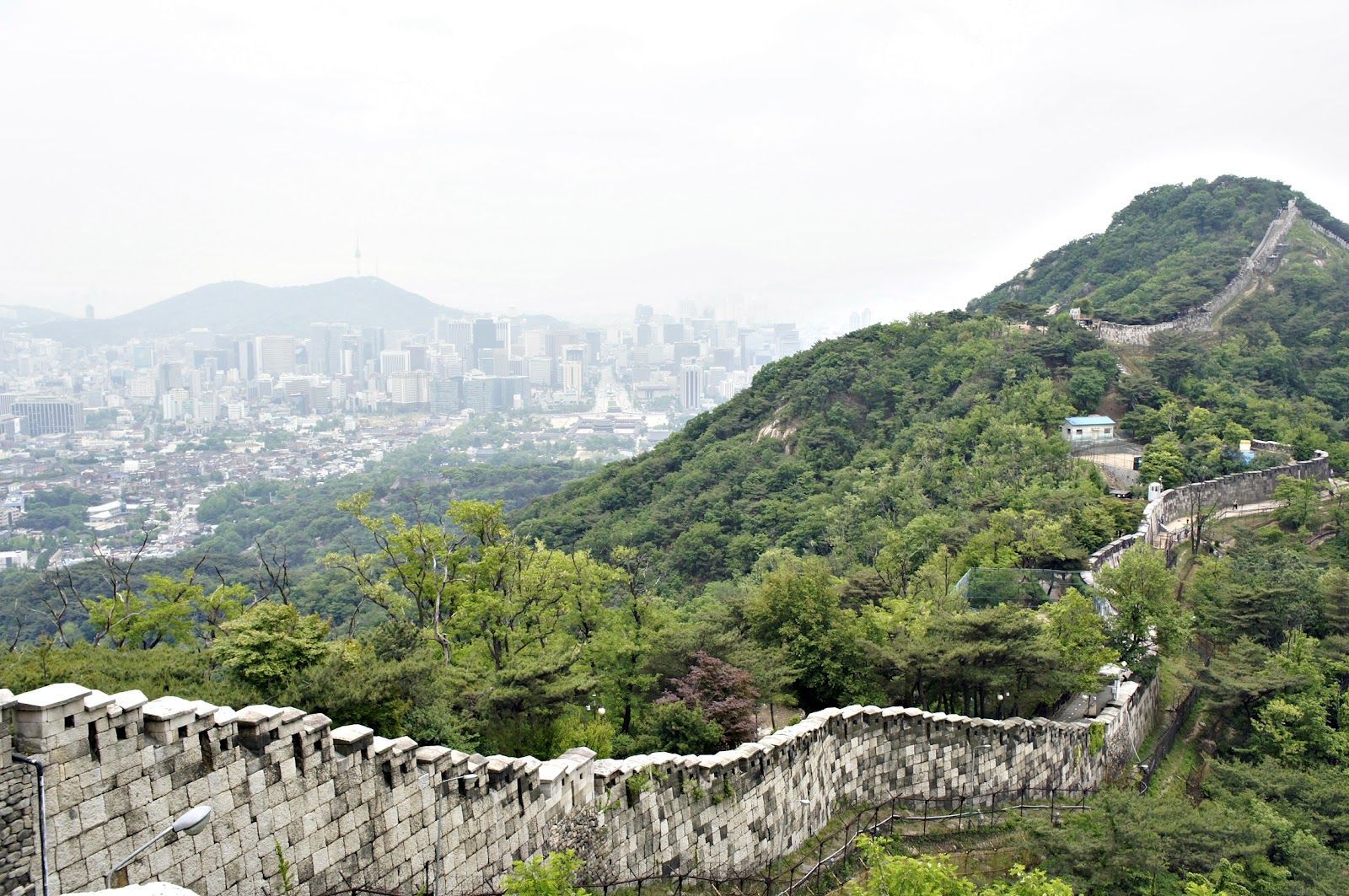
## Description The Seoul Fortress Wall traces the historic boundary of old Seoul, and the Inwangsan section is one of the most compelling short hikes inside the city. Winding stone walls, watchtowers, and narrow ridgelines create a dramatic contrast between rugged natural rock and the modern urban panorama below. Inwangsan (인왕산) itself is a modest peak by elevation, but its steep faces and rocky outcrops make the Fortification route visually striking and surprisingly variable: you pass restored wall segments, crenellated parapets, traditional gates, and quieter stretches where the original stonework blends into pine and ginkgo trees. This route is part walking trail, part living history. Along the Inwangsan section, you can stand at viewpoints that look directly toward Gyeongbokgung Palace and central Seoul, making it a favorite for photographers who want a skyline shot with a distinctly Korean architectural foreground. The combination of natural features and preserved cultural sites gives the trail strong context—archaeologists and local historians point to ritual sites and small petroglyphs on some of the rocky ledges, evidence that the hill has been significant for much longer than the Joseon-era fortifications. For travelers who prioritize accessible day hikes, Inwangsan is practical: the trails are short enough to be combined with a half-day of exploring nearby neighborhoods (Seochon, Buam-dong, or the area around Gyeongbokgung). The experience can feel intimate and unhurried, especially outside popular weekends. For SEO and practical trip planning, search terms that pair well with this route are "Seoul Fortress Wall Inwangsan hike", "Inwangsan panoramic views", and "Seoul city wall trail Gyeongbokgung viewpoint"—phrases locals and travel platforms commonly use. ## Location Inwangsan rises above central Seoul and is most easily accessed on foot from neighborhoods close to Gyeongbokgung Palace and Hyehwa. Nearby subway stations include Gyeongbokgung Station (Line 3) and Hyehwa Station (Line 4); from either point, a 10–25 minute walk brings you to the trailheads depending on your route. Many visitors combine a morning or afternoon at Gyeongbokgung with a short hike up Inwangsan to make efficient use of time. Public transit directions are straightforward: take the subway to Gyeongbokgung or Hyehwa, then follow signs toward the fortress wall trail or ask at local cafes. There are several access points—some are steeper and more direct, others weave through residential lanes and feel more gradual. Maps and local wayfinding often label the path as part of the Seoul City Wall trail network—which helps when using mapping apps or planning a multi-stop day. ## Tips - Hike in the cooler parts of the day: early morning or late afternoon provides the best light for photos and avoids midday crowds and heat. - Wear supportive shoes: some stretches are rocky and uneven; closed-toe hiking shoes or trail runners are recommended. - Bring water and a light snack: although the trail is short, the elevation gain and rocky scrambles benefit from hydration and quick energy. - Be mindful of cultural sites: certain rock ledges and small shrines are used for ritual or prayer—treat them respectfully and avoid disturbing offerings. - Use a map or offline navigation: parts of the trail pass behind residential areas and signage can be minimal; a downloaded map or route screenshot helps. - Combine with nearby visits: pair the hike with a visit to Gyeongbokgung Palace, Seochon’s galleries, or the Buam-dong cafes to make a full half-day itinerary. - Photography tip: for skyline shots with the palace, position yourself on the western-facing viewpoints late in the afternoon for warm light on the stone walls and cool city contrasts. ## Conclusion The Inwangsan section of the Seoul Fortress Wall blends accessible urban hiking with layered history and excellent skyline views. It’s ideally suited for travelers who want a short outdoor escape with high visual return and cultural interest. Whether you pause for a skyline photograph, linger at a watchtower, or simply enjoy the contrast of stone and city, Inwangsan rewards an inquisitive walk and mixes well with central Seoul sightseeing. ## FAQ Q: How long does the Inwangsan trail take? A: Typical loop or ascent routes take 45–90 minutes depending on pace, photo stops, and which trailhead you pick. Q: Is the trail suitable for children or older visitors? A: Many sections are family-friendly, but some parts include short rocky scrambles and steps—evaluate mobility and consider shorter, lower-angle access routes for older visitors. Q: Are parts of the wall restricted or closed at certain times? A: Most sections are open to the public daily, but occasional restoration work or local ceremonies can temporarily limit access—check local signage or community updates. Q: Can I climb on the walls and gates? A: For safety and preservation, avoid climbing on fragile stonework; use designated paths and viewpoints to minimize wear on historic structures. Q: Is there an entrance fee or permit needed? A: No entrance fee—this is a publicly accessible municipal trail and heritage site. ## Links - [Seoul City Wall (Wikipedia)](https://en.wikipedia.org/wiki/Seoul_City_Wall)
GemVoyage Team • World
Cologne
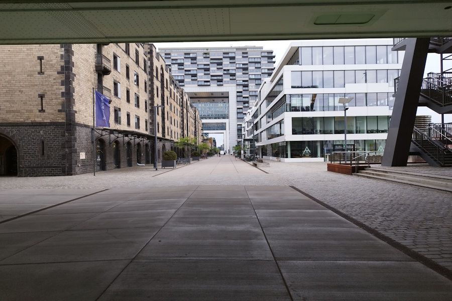
## Description The Rheinauhafen District in Cologne exemplifies thoughtful urban redevelopment: a former industrial harbor reimagined as a walkable district of offices, housing, restaurants, and public promenades. Its most striking architectural features are the crane houses (Kranhäuser), modern structures that reference the port's past while creating a distinctive skyline along the Rhine. The district combines strong visual identity with accessible public space, making it an appealing stop for visitors and locals alike. What makes Rheinauhafen particularly interesting is its balance of design ambition and pragmatic public access. The promenades invite walking and cycling; riverside cafés and small parks encourage lingering; and the architecture rewards both appreciation and photography. The transformation of the former harbor area into a mixed-use neighborhood has become one of Cologne's most visible examples of urban regeneration, and the district sits comfortably alongside the city's historic core. ## Location Rheinauhafen lies along the Rhine south of Cologne's Old Town, a short walk from key central attractions. It is well connected by tram, bus, and pedestrian routes, allowing easy integration into walking tours that include the cathedral, museums, and the Old Town. The district's linear layout along the river makes it particularly suited to a riverside walk that can be shortened or extended depending on your schedule. Because Rheinauhafen is adjacent to major city sights, it functions well as an extension of a cultural itinerary—grab coffee or lunch here after a museum visit, or plan an evening walk to see the waterfront at sunset. ## Tips - Explore on foot to appreciate perspectives from both the promenade and the opposite bank of the Rhine. - Bring a camera for architectural details and reflections on the river surface—sunset light is especially flattering. - Combine the visit with nearby Old Town attractions, museums, or a Rhine river cruise for variety. - Stop at a riverside café or bistro to turn a quick photo stop into a leisurely break. - If cycling, use the well-maintained paths but be mindful of pedestrians along popular stretches. - Check events calendars: the promenade sometimes hosts markets or cultural events that enrich a visit. ## Conclusion Rheinauhafen is a model of how contemporary design can coexist with historic city fabric. It is a polished, open, and welcoming district that rewards unhurried exploration and flexible itineraries—whether you come for architecture, a riverside walk, or a relaxed café stop. ## FAQ ### What is Rheinauhafen known for? It is best known for its crane houses and the successful transformation of a former industrial harbor into a mixed-use, riverfront district. ### Is Rheinauhafen good for walking? Yes—its promenades and river views make it ideal for a comfortable stroll, photography, and small detours into cafés and galleries. ### How long should I spend there? An hour or two is fitting for a leisurely walk and photos; combine it with nearby attractions for a half-day or full-day plan. ### Is it more for locals or tourists? Both. Locals use the promenade for daily walks and dining, while visitors come for architecture and river views; the mix gives the district an authentic feel. ### What should I see nearby? Cologne's Old Town, the cathedral, and riverside museums are all within easy reach and pair well with a Rheinauhafen visit. ## Links - [Wikipedia](https://en.wikipedia.org/wiki/Rheinauhafen)
GemVoyage Team • World
Alexandria
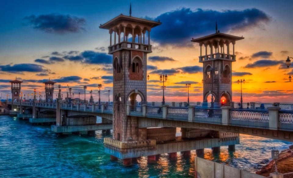
## Description The Stanley Bridge Corniche Walk is one of the most enjoyable ways to experience Alexandria’s seaside character because it brings together a famous city landmark and the broader rhythm of the Mediterranean waterfront. Stanley Bridge itself is a recognizable symbol of modern Alexandria, but what makes the area memorable is not only the bridge as an object. It is the surrounding promenade, the sea air, the movement of people, the views toward the coastline, and the way the corniche helps connect the city’s urban life with its maritime setting. For visitors, this is the kind of place that turns a simple walk into an experience of atmosphere. The bridge and the walkway around it are especially appealing because they capture Alexandria’s layered identity. The city has ancient roots, but much of its contemporary charm comes from places where residents and visitors mix along the water. A lesser-known fact is that the Stanley area is relatively modern compared with Alexandria’s ancient core, yet it has become one of the city’s most photographed and recognizable places because of its coastal setting and architectural profile. Another detail worth noticing is how the area changes across the day: morning brings a softer, more reflective mood, while evening often becomes livelier as people come out for a breezy promenade. For travelers, the walk is rewarding because it offers a sense of place without requiring a formal agenda. You can simply move along the corniche, stop for photos, watch traffic and waves, and enjoy the city unfolding in layers. The bridge frames the sea and the shoreline in a way that feels distinctly Alexandrian, and the surrounding area is often a pleasant place to pause, drink something cold, or continue toward nearby stretches of the waterfront. That flexibility is exactly why this walk belongs in an Alexandria itinerary. The best part may be how accessible it feels. You do not need special preparation to appreciate it. The waterfront itself does the work, offering changing light, open views, and a strong sense of local daily life. ## Location Stanley Bridge Corniche Walk is located in Alexandria, Egypt, along the city’s Mediterranean waterfront in the Stanley district. The walk sits on the Corniche, Alexandria’s main coastal boulevard, which makes it easy to locate and simple to fold into a broader day in the city. Because it is part of the public waterfront, the area is easy to approach and does not require special ticketing or entrance procedures. Getting there is usually easiest by taxi, rideshare, or local transport depending on where you are staying in Alexandria. Walking is ideal if you are already nearby, since the whole point of the experience is to enjoy the seafront at a human pace. If you are planning a longer sightseeing route, Stanley works well as a connecting point between central Alexandria and other coastal areas. The best way to enjoy it is to arrive with enough time to linger. A short pass-through is fine, but the waterfront rewards slowing down. Sunset is especially attractive for light and atmosphere, though morning can be calmer and better for a more relaxed walk. ## Tips Choose comfortable shoes, even though the route is simple. A pleasant walk often turns into a longer one than expected. Visit near sunset if you want the most dramatic light and the most social atmosphere. Do not focus only on the bridge itself. The surrounding corniche is what gives the experience its full value. Be aware of traffic and keep an eye on crossings. Like many urban waterfronts, the area is lively and active. Combine the walk with a café stop or a meal nearby so the outing feels complete rather than rushed. ## Conclusion The Stanley Bridge Corniche Walk is one of Alexandria’s most enjoyable low-effort experiences, blending sea views, city life, and a strong sense of place. It is ideal for travelers who want to feel the Mediterranean character of the city without needing a formal attraction schedule. ## FAQ ### Is the Stanley Bridge area good for tourists? Yes. It is one of Alexandria’s most scenic and accessible waterfront spots, with strong appeal for casual visitors and photographers. ### How long should I spend there? Anywhere from 30 minutes to 2 hours, depending on whether you are simply passing through or lingering for a walk and a meal. ### Is it better in the day or evening? Both work well. Daylight is good for seeing the sea clearly, while evening often feels more atmospheric and social. ### Do I need a ticket? No. The corniche is a public waterfront area, so the experience is generally open and walkable. ## Links - [Alexandria on Wikipedia](https://en.wikipedia.org/wiki/Alexandria)
GemVoyage Team • World

Comments