Discover extraordinary places shared by our community of travelers
Rome
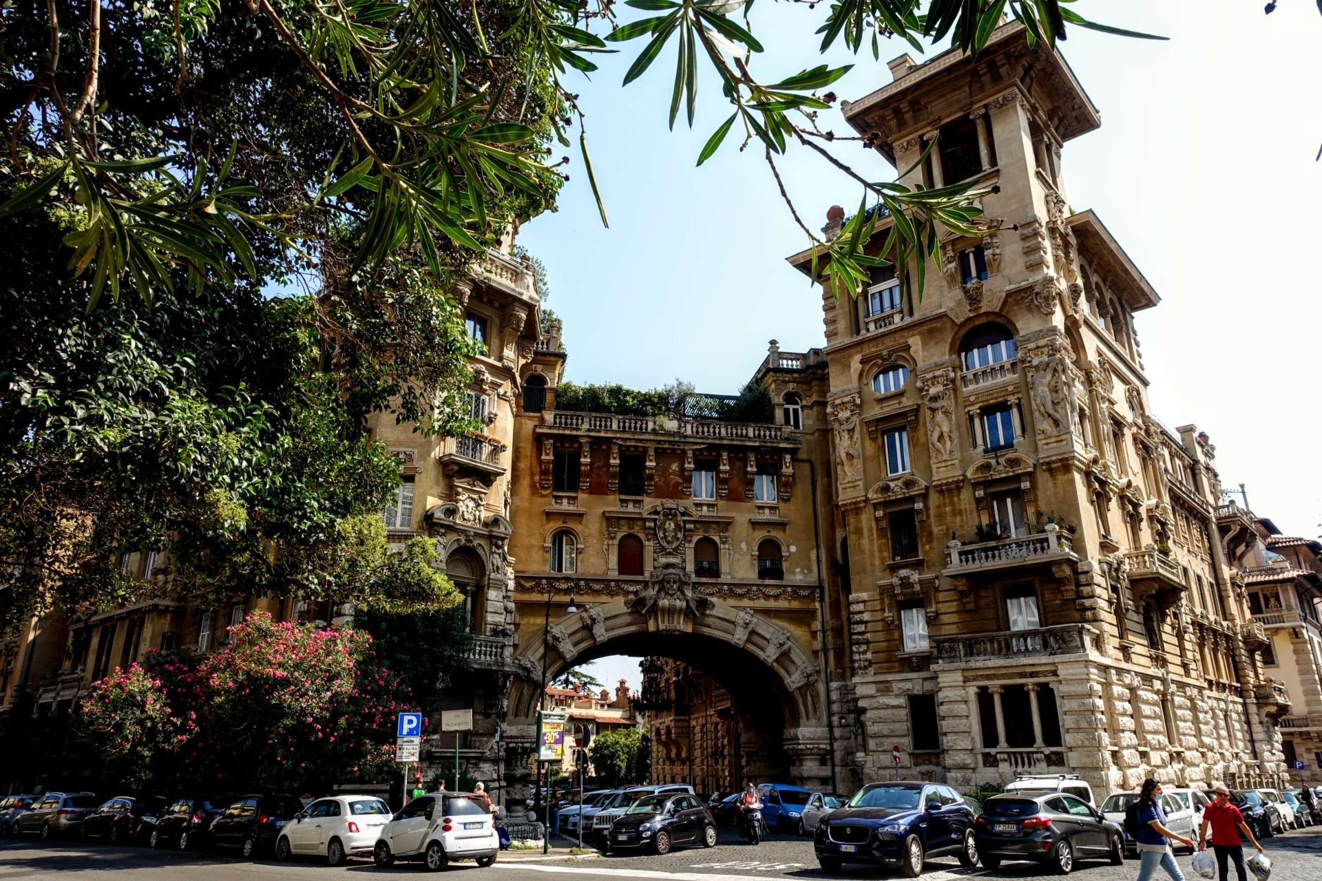
## Description Quartiere Coppedè is a compact Roman quarter that reads like an architectural storybook—an eclectic fusion of Art Nouveau, Gothic, Baroque, and medieval motifs created by architect Gino Coppedè in the early 20th century. Unlike Rome’s grand classical boulevards, Coppedè’s charm is intimate and ornamental: ornate street lamps, intricate stone reliefs, and allegorical sculptures populate small piazzas and manicured courtyards. The area feels deliberately theatrical—cobblestones, carved masks, and decorative columns create a sense of discovery around every corner. The district’s central Fountain of the Frogs remains the visual and social heart of Coppedè, anchoring a piazza that draws photographers and architecture lovers. Film crews and editorial shoots often favor the quarter for its cinematic, slightly surreal quality. A lesser-known nuance is the abundance of small symbolic details—carvings referencing mythology, architecture that blends multiple historical styles on a single facade, and discreet plaques that hint at the designer’s playful intentions. ## Location Quartiere Coppedè sits in the Trieste/Salario area north of Rome’s historic center. It’s reachable by bus or a reasonable walk from Termini station; for many visitors it makes a pleasant detour when exploring Rome beyond the core tourist sites. ## Tips - Stroll slowly and look upward—facade details, rooftop ornaments, and carved symbols reward slow observation. - Visit during daylight to appreciate the color and texture of stonework and decorative elements. - Wear comfortable shoes; the best views are found while wandering rather than following a strict route. - Be respectful of residents—this is a lived neighborhood, not a theme park; avoid loud behavior and tread lightly in quieter corners. - Photography: mornings with soft light offer the best conditions; golden-hour photos can be striking but be mindful of private courtyards. ## Conclusion Quartiere Coppedè is a short, enchanting detour from Rome’s classical itinerary: a neighborhood where architectural imagination runs free and every facade tells a visual story. It’s a must-see for travelers interested in design, film-worthy backdrops, and the unexpected pleasures of urban ornamentation. ## FAQ Q: Is Quartiere Coppedè crowded? A: It is generally peaceful and residential—most visitors are architecture enthusiasts rather than mass-tourist groups. Q: Are guided tours available for Coppedè? A: Yes, some walking tours include Coppedè as part of broader neighborhood routes, and independent guides can tailor visits for architecture lovers. Q: Can I enter the buildings in Coppedè? A: Many buildings are private residences; admire the ornate facades from the street and respect private property. Q: What is the best time of day to visit? A: Morning or late afternoon for softer light and fewer people—midday can be busier and harsher for photos. Q: Are there nearby cafes or amenities? A: Yes—small cafes and restaurants are within walking distance in the Trieste area; stop for a coffee after exploring. ## Links - [Quartiere Coppedè](https://rome.us/neighborhoods/quartiere-coppede.html)
GemVoyage Team • World
Seoul
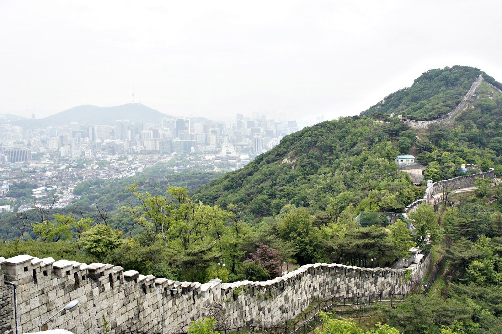
## Description The Seoul Fortress Wall traces the historic boundary of old Seoul, and the Inwangsan section is one of the most compelling short hikes inside the city. Winding stone walls, watchtowers, and narrow ridgelines create a dramatic contrast between rugged natural rock and the modern urban panorama below. Inwangsan (인왕산) itself is a modest peak by elevation, but its steep faces and rocky outcrops make the Fortification route visually striking and surprisingly variable: you pass restored wall segments, crenellated parapets, traditional gates, and quieter stretches where the original stonework blends into pine and ginkgo trees. This route is part walking trail, part living history. Along the Inwangsan section, you can stand at viewpoints that look directly toward Gyeongbokgung Palace and central Seoul, making it a favorite for photographers who want a skyline shot with a distinctly Korean architectural foreground. The combination of natural features and preserved cultural sites gives the trail strong context—archaeologists and local historians point to ritual sites and small petroglyphs on some of the rocky ledges, evidence that the hill has been significant for much longer than the Joseon-era fortifications. For travelers who prioritize accessible day hikes, Inwangsan is practical: the trails are short enough to be combined with a half-day of exploring nearby neighborhoods (Seochon, Buam-dong, or the area around Gyeongbokgung). The experience can feel intimate and unhurried, especially outside popular weekends. For SEO and practical trip planning, search terms that pair well with this route are "Seoul Fortress Wall Inwangsan hike", "Inwangsan panoramic views", and "Seoul city wall trail Gyeongbokgung viewpoint"—phrases locals and travel platforms commonly use. ## Location Inwangsan rises above central Seoul and is most easily accessed on foot from neighborhoods close to Gyeongbokgung Palace and Hyehwa. Nearby subway stations include Gyeongbokgung Station (Line 3) and Hyehwa Station (Line 4); from either point, a 10–25 minute walk brings you to the trailheads depending on your route. Many visitors combine a morning or afternoon at Gyeongbokgung with a short hike up Inwangsan to make efficient use of time. Public transit directions are straightforward: take the subway to Gyeongbokgung or Hyehwa, then follow signs toward the fortress wall trail or ask at local cafes. There are several access points—some are steeper and more direct, others weave through residential lanes and feel more gradual. Maps and local wayfinding often label the path as part of the Seoul City Wall trail network—which helps when using mapping apps or planning a multi-stop day. ## Tips - Hike in the cooler parts of the day: early morning or late afternoon provides the best light for photos and avoids midday crowds and heat. - Wear supportive shoes: some stretches are rocky and uneven; closed-toe hiking shoes or trail runners are recommended. - Bring water and a light snack: although the trail is short, the elevation gain and rocky scrambles benefit from hydration and quick energy. - Be mindful of cultural sites: certain rock ledges and small shrines are used for ritual or prayer—treat them respectfully and avoid disturbing offerings. - Use a map or offline navigation: parts of the trail pass behind residential areas and signage can be minimal; a downloaded map or route screenshot helps. - Combine with nearby visits: pair the hike with a visit to Gyeongbokgung Palace, Seochon’s galleries, or the Buam-dong cafes to make a full half-day itinerary. - Photography tip: for skyline shots with the palace, position yourself on the western-facing viewpoints late in the afternoon for warm light on the stone walls and cool city contrasts. ## Conclusion The Inwangsan section of the Seoul Fortress Wall blends accessible urban hiking with layered history and excellent skyline views. It’s ideally suited for travelers who want a short outdoor escape with high visual return and cultural interest. Whether you pause for a skyline photograph, linger at a watchtower, or simply enjoy the contrast of stone and city, Inwangsan rewards an inquisitive walk and mixes well with central Seoul sightseeing. ## FAQ Q: How long does the Inwangsan trail take? A: Typical loop or ascent routes take 45–90 minutes depending on pace, photo stops, and which trailhead you pick. Q: Is the trail suitable for children or older visitors? A: Many sections are family-friendly, but some parts include short rocky scrambles and steps—evaluate mobility and consider shorter, lower-angle access routes for older visitors. Q: Are parts of the wall restricted or closed at certain times? A: Most sections are open to the public daily, but occasional restoration work or local ceremonies can temporarily limit access—check local signage or community updates. Q: Can I climb on the walls and gates? A: For safety and preservation, avoid climbing on fragile stonework; use designated paths and viewpoints to minimize wear on historic structures. Q: Is there an entrance fee or permit needed? A: No entrance fee—this is a publicly accessible municipal trail and heritage site. ## Links - [Seoul City Wall (Wikipedia)](https://en.wikipedia.org/wiki/Seoul_City_Wall)
GemVoyage Team • World
Rome
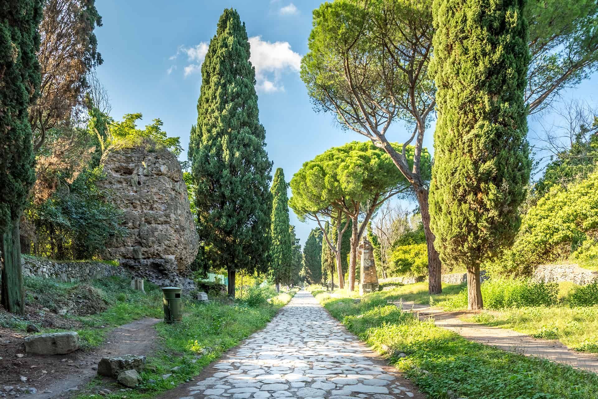
## Description The Appian Way (Via Appia Antica) is one of the most evocative ancient roads in Europe, running southeast from Rome and threading tombs, ruins, and the remains of Roman infrastructure through a pastoral corridor. Lined with funerary monuments and early Christian catacombs, sections of the route preserve original Roman paving and milestones that offer a tangible link to antiquity. Walking, cycling, or riding portions of the Appian Way reveals layers of history: imperial-era tombs, remains of villas, and quieter stretches where the path feels remarkably rural despite being inside Rome's larger urban boundary. Beyond the monuments, the Appian Way is also a public park and archaeological corridor, with protected areas that encourage slow exploration. Many travelers prefer to rent bicycles to cover more ground, though walking smaller stretches provides time to read inscriptions, visit specific catacombs, and take photographs without hurrying. Search-relevant phrases to plan a visit include "Appian Way Rome bike rental", "Via Appia Antica catacombs", and "walk the Appian Way"—terms that match travel guides and visitor resources. ## Location Via Appia Antica begins near the Aurelian Walls and continues southeast into the Roman countryside. Key visitor access points include the Appian Way Park Visitor Center and the areas near the Baths of Caracalla. Public transit options include buses that stop near the main entrances; taxis and bike rentals from central Rome are also common. Parts of the road become parkland with restricted car access, which makes cycling and walking safer and more pleasant. ## Tips - Rent a bike to see more of the route in a single visit: many rental shops offer city pickups and drop-offs near the park. - Visit catacombs with a guide: guided tours provide historical context and access to sites that close early or require reservations. - Wear durable shoes: while paved in places, many stretches have uneven ancient stones—sturdy footwear prevents slips and makes exploration easier. - Start early to avoid midday heat and to capture softer morning light for photography. - Bring water and snacks: services are limited along some stretches, so pack essentials for longer rides or walks. - Respect preservation rules: follow designated paths and do not remove artifacts or disturb archaeological features. ## Conclusion The Appian Way is a living museum and countryside escape rolled into one: accessible, atmospheric, and rich with Roman history. Whether you're cycling past tombs or pausing in a quiet olive grove, the route offers a memorable way to connect with ancient Rome's infrastructure and the everyday topography that shaped imperial travel. ## FAQ Q: How long is the Appian Way and how much can I cover in a day? A: The historic Appian Way stretches for many kilometers; most visitors focus on a 10–20 km segment near Rome that can be walked or cycled in a half-day to full-day depending on pace. Q: Are bicycles available for rent near the Appian Way? A: Yes—bike rental shops and guided bike tours operate from central Rome and near the park entrances. Q: Can I visit catacombs along the Appian Way without a guide? A: Some catacombs permit independent visits, but many recommend or require guided entry to provide context and control visitor numbers—check schedules in advance. Q: Is the Appian Way accessible year-round? A: Generally yes, though some sites and visitor centers follow seasonal hours; winter weather can be cooler and quieter, while spring and fall are popular. Q: Are there food and restroom facilities along the route? A: Basic facilities are available near major access points and visitor centers, but services are sparse in remote stretches—plan accordingly. ## Links - [Appian Way (Wikipedia)](https://en.wikipedia.org/wiki/Appian_Way)
GemVoyage Team • World
Cape Town
## Description Newlands Forest is one of Cape Town’s most accessible green escapes, especially for travelers who want a walk in nature without committing to a major mountain expedition. Located on the southern slopes of Table Mountain, it offers a softer, shadier, and more intimate side of the city’s mountain landscape. The forest feels close to urban life yet separated enough to create genuine calm, which is why it is popular with walkers, runners, families, and anyone needing a quieter outdoor break. The forest is attractive because it gives you variety in a small space. Paths wind through trees, slopes, and scenic pockets that change with light and season. In some sections the canopy feels dense and almost enclosed; in others, the forest opens enough to remind you how close you are to one of the world’s most distinctive mountain systems. One little-known fact is that Newlands Forest is often chosen by locals who want a manageable outing rather than a full mountain climb. Another is that the forest’s location means it can function as both a fitness space and a restorative natural retreat. Visitors often appreciate the contrast between the forest and the city. Cape Town can feel dramatically coastal or highly urban, but Newlands Forest offers a middle ground where the city seems far enough away to rest the mind while still being reachable without complicated planning. That accessibility is one of its major strengths. You do not need to be an expert hiker to enjoy it. Even a short walk can be rewarding because the atmosphere itself is the attraction. The area also has a calm, local character that makes it feel welcoming. People come here for different reasons and at different paces, so the forest never feels like it belongs to only one type of visitor. Whether you want exercise, shade, birdlife, or a quiet pause in your day, Newlands Forest can accommodate it. That flexibility makes it an especially useful stop for people spending several days in Cape Town and looking for a restorative half-day outdoors. ## Location Newlands Forest is located in Newlands, in the southern part of Cape Town, Western Cape, South Africa, on the lower slopes of Table Mountain National Park. It is close to residential areas, sports venues, and other southern suburbs, which makes it one of the easier nature spots to access from within the city. The simplest way to get there is by car or ride-hailing service. Depending on where you start, public transport may be less direct, so a point-to-point ride is often the most practical option. Parking and trail access can vary by exact route, so it helps to decide ahead of time whether you want a short stroll, a longer hike, or a connection to a broader mountain route. Because the forest is part of a bigger natural system, weather conditions matter. Dry, clear days are usually most comfortable, and early starts are helpful if you want a peaceful atmosphere and cooler temperatures. ## Tips - Wear proper walking shoes even for a short visit. Paths can be uneven in places. - Bring water and sun protection, especially if you plan to continue beyond shaded sections. - Start early in the day for quieter trails and more comfortable temperatures. - Stick to marked paths and pay attention to trail conditions. - Use the forest as part of a broader Cape Town nature day if you want a balanced outing. ## Conclusion Newlands Forest offers Cape Town visitors an easy, restorative encounter with the mountain environment. It is a place to walk, breathe, and reset without needing to leave the city far behind. ## FAQ ### Is Newlands Forest suitable for beginners? Yes. Many routes and walks in the area are approachable, though you should still choose a route that matches your comfort level. ### How long should I plan to stay? A short visit can be as little as an hour, but you can easily extend it into a half-day depending on your route and pace. ### Is it more of a hike or a walk? It can be either. Some visitors treat it as a gentle walk, while others use it as the starting point for more active hiking. ### Is it busy? It can be popular, especially on pleasant days and weekends, but it still often feels calmer than many other city-based attractions. ## Links - [Newlands Forest on Wikipedia](https://en.wikipedia.org/wiki/Newlands_Forest)
GemVoyage Team • World
Stockholm
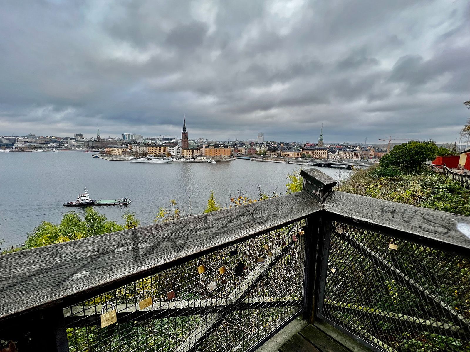
## Description Monteliusvägen is one of Stockholm’s most beloved viewpoint walks because it offers a remarkable amount of scenery for very little effort. Stretching along Mariaberget in Södermalm, the path gives visitors panoramic views over Riddarfjärden, City Hall, and the water and skyline that define Stockholm’s visual identity. It is a place where walking becomes part of the sightseeing itself, and where the city looks especially elegant in changing light. The viewpoint’s appeal lies in its mixture of accessibility and atmosphere. You do not need to climb a mountain or travel far from the center to get a memorable outlook. Instead, you can step into a residential and elevated part of the city and find a broad view that feels almost theatrical. One little-known fact is that Monteliusvägen is particularly admired by locals for how reliably it delivers a strong skyline view without the crowds associated with more obvious tourist stops. Another is that the path changes character with the seasons; winter can make the scenery crisp and graphic, while summer brings long, luminous evenings and a more relaxed mood. What also makes Monteliusvägen special is that it combines motion and pause. As you walk, the city opens and closes in layers. You might pass benches, low walls, and quiet residential details, then suddenly find a view that feels worthy of a postcard. That rhythm encourages visitors to slow down rather than rush through. It is a great place to arrive without a fixed plan, because the reward comes from both the walk and the destination. For photographers and casual visitors alike, the viewpoint is one of Stockholm’s most satisfying urban experiences. It captures the city’s relation to water, its elegant low-rise skyline, and its subtle balance between nature and urban form. A sunset visit can be particularly memorable, but the viewpoint works at many times of day because the geometry of the city and the water remains compelling even in flat light. ## Location Monteliusvägen is located on Mariaberget in Södermalm, Stockholm, Sweden, overlooking the waters of central Stockholm. It is very close to the city core, which makes it easy to include in a broader city walk. Because it sits on a ridge above the water, the route includes some uphill movement, but the climb is short and manageable. The easiest access is via Stockholm’s metro system to nearby stations such as Slussen, followed by a walk through Södermalm. From there, signage and local navigation are usually straightforward enough for most visitors to find the viewpoint. Since the area is so central, it is simple to pair it with a coffee stop, dinner, or a longer Södermalm exploration. If you want the best photo conditions, go near sunset or during the soft light of early morning. For a quieter experience, avoid peak sightseeing hours when possible. ## Tips - Go at sunset if you want the most dramatic light on the water and skyline. - Wear comfortable shoes because the approach includes some uphill walking. - Bring a jacket or layer, especially if you stay after sunset when wind can feel cooler. - Walk slowly and stop more than once. The viewpoint changes as you move along it. - Combine Monteliusvägen with another Södermalm stop so the outing feels complete. ## Conclusion Monteliusvägen is one of Stockholm’s most rewarding short walks, offering a classic view of the city with little logistical effort. It is simple, beautiful, and especially strong at sunset. ## FAQ ### Is Monteliusvägen worth it if I have only one day in Stockholm? Yes. It is one of the quickest ways to get a memorable city view without a complicated excursion. ### How long is the walk? The walking stretch is fairly short, but you will likely spend more time stopping to enjoy the views than actually moving. ### Is it very crowded? It can be popular, especially around sunset, but it still often feels calmer than the most famous Stockholm viewpoints. ### Is it family-friendly? Yes, as long as everyone is comfortable with a little uphill walking and staying attentive near ridge-edge paths. ## Links - [Visit Stockholm](https://www.visitstockholm.com/)
GemVoyage Team • World
Bonn
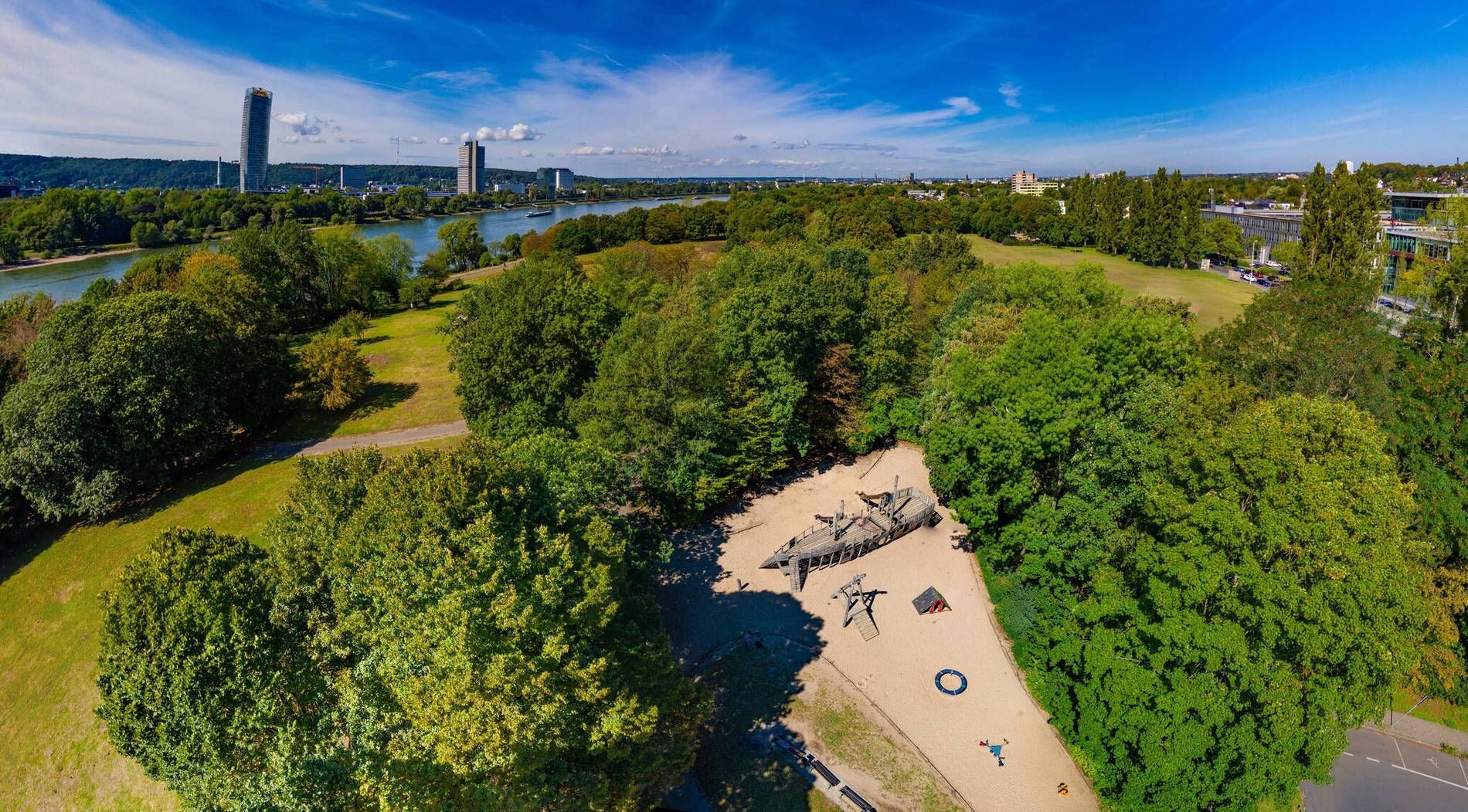
## Description Rheinaue Park is one of Bonn’s most pleasant urban green spaces because it combines openness, variety, and a strong sense of everyday usefulness. It is the kind of park that feels instantly welcoming. Instead of presenting itself as a highly formal landscape or a single-activity site, it offers lawns, water features, walking paths, and room to simply be outside. For travelers, that makes it a gentle and flexible stop; for locals, it functions as a regular escape from the city’s pace. The park stands out because of its scale and composition. Broad open areas give it a relaxed, spacious feeling, while the presence of water and planted sections creates enough visual interest to keep a long walk engaging. One little-known fact is that the park was shaped by a major landscape design approach rather than emerging as a simple leftover green area, which explains why it feels so intentional and balanced. Another is that it works especially well in different weather conditions: sunny days bring picnic energy and wide horizons, while overcast days make the water and greenery feel especially calm. Visitors often appreciate that Rheinaue Park feels lived-in rather than overly staged. People come here to walk, cycle, picnic, exercise, or spend time with family and friends. That mixed use gives the park a stable, local rhythm. It is not an attraction you rush through. It is a place that rewards taking your time, noticing how people use the space, and choosing your own pace. The park is also useful for travelers who want an easy outdoor break without a complicated plan. After time in Bonn’s museums, old town, or riverfront, Rheinaue offers a reset. You can settle into a bench, cross open lawns, follow a trail near the water, or simply enjoy the change of scale from city streets to open parkland. It is the sort of place that may not dominate a guidebook cover but ends up becoming one of the most restful parts of a trip. ## Location Rheinaue Park is located in Bonn, North Rhine-Westphalia, Germany, stretching through a large green area in the city and near the Rhine. Its size and layout make it accessible from several directions, and it functions as one of Bonn’s major recreational landscapes. The easiest way to reach the park is by local public transport, bicycle, or car depending on where you start in the city. Because Bonn is relatively manageable, many visitors find that a bike or short transit ride works especially well. The park’s openness means that once you arrive, you can decide how long or how far you want to walk without needing a rigid route. If you are planning a relaxed visit, choose good weather and give yourself time to move slowly. The park is best experienced as a place for lingering rather than ticking off sights. ## Tips - Bring water or a picnic if you want to make the most of the open lawns. - Use the park for a slow walk or bike ride rather than trying to treat it as a quick stop. - Visit in good weather if you want the full effect of the open landscape. - Leave time for sitting. The park is as much about atmosphere as activity. - Combine it with Bonn’s riverfront or central sights if you want a fuller day out. ## Conclusion Rheinaue Park is Bonn’s easygoing green escape, offering space, water views, and a calm setting that works well for both local routines and traveler downtime. It is simple, generous, and quietly rewarding. ## FAQ ### Is Rheinaue Park a tourist attraction or mainly a local park? It serves both purposes. Tourists can enjoy the space and scenery, while locals use it regularly for exercise, relaxation, and social time. ### How much time should I spend there? Anywhere from an hour to several hours, depending on whether you want just a walk or a more relaxed picnic-style visit. ### Is it good for children? Yes. The open space and easy paths make it a flexible destination for families. ### When is the best time to visit? Spring, summer, and early autumn are especially pleasant, though the park can be enjoyable year-round. ## Links - [Bonn official website](https://www.bonn.de/)
GemVoyage Team • World
Stockholm
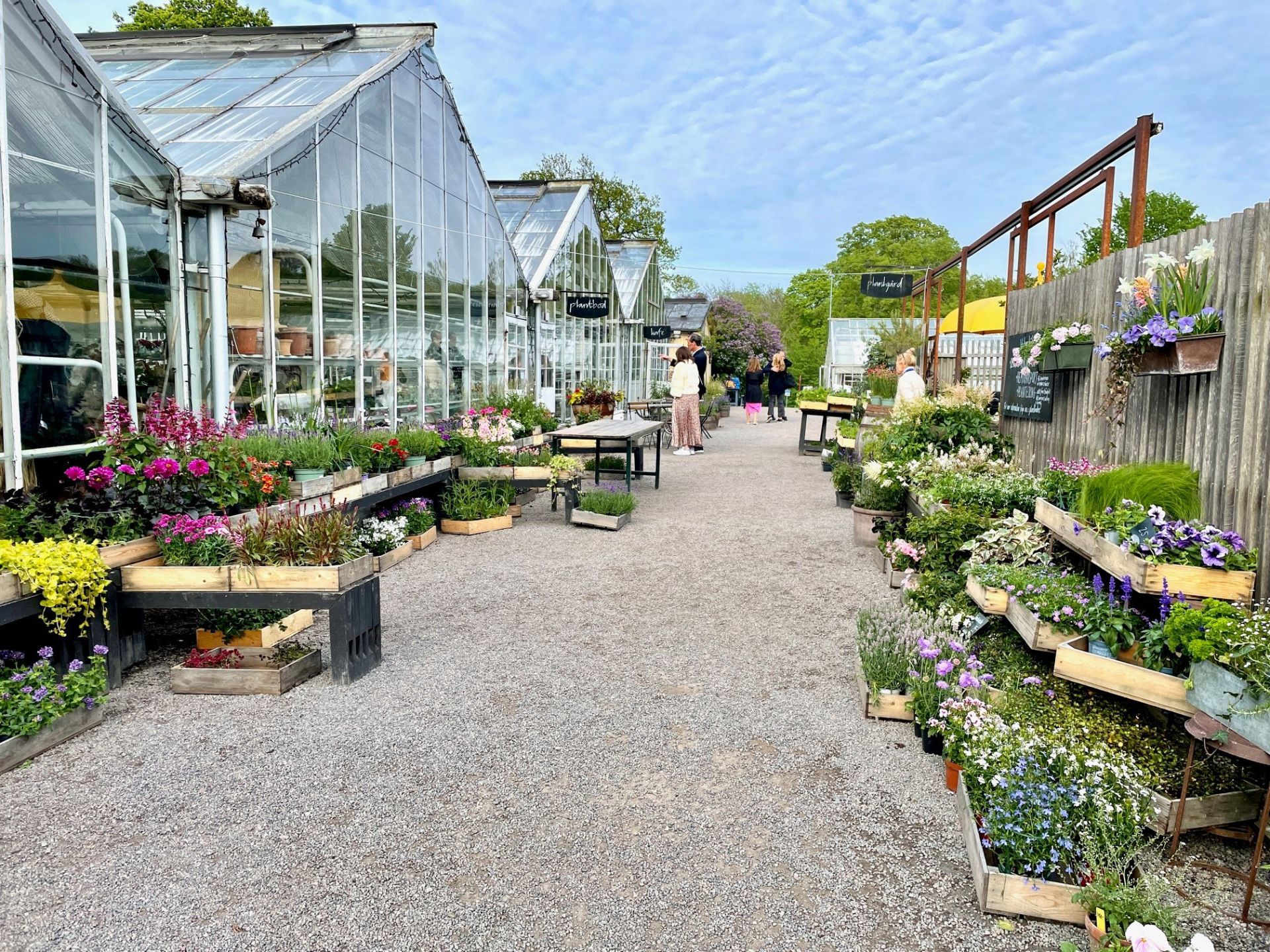
## Description Rosendals Trädgård is one of those rare places that feels both deeply local and immediately memorable. Set on the green island of Djurgården in Stockholm, the garden combines ornamental planting, seasonal produce, a working nursery, a bakery, and an inviting café into one relaxed destination. Visitors often come expecting a pretty garden and leave with the feeling that they have experienced a small ecosystem of Scandinavian food culture, horticulture, and outdoor life. It is not a formal palace garden or a purely decorative park; it is a living place where flowers, vegetables, fruit trees, and people all share the same rhythm. What makes Rosendals stand out is the way it blends simplicity with refinement. The garden is run according to biodynamic and organic principles, which means the whole experience is shaped by seasonal cycles rather than constant uniformity. In spring, the beds begin quietly with bulbs, tender greens, and early blossoms. Summer brings fuller borders, kitchen-garden abundance, and long café days outdoors. Autumn is particularly appealing if you like apples, late flowers, and the warm colors of Scandinavian foliage. Even in winter, the place has a calm, understated beauty that suits Stockholm well. One of the little-known pleasures here is how much of the visitor experience is tied to the practical side of gardening. The nursery and shop are not just decorative add-ons; they reflect the same philosophy that shapes the grounds. That means you can often buy plants, flowers, and food items that feel connected to the same landscape you have just walked through. Another detail many visitors overlook is how strongly Rosendals represents the Swedish idea of taking everyday food seriously without making it stiff or formal. A simple pastry or lunch here can feel like an essential part of the attraction rather than an afterthought. The atmosphere is gentle rather than dramatic, which is exactly why it works. Rosendals is a place to slow down. You can wander among orchard rows, admire carefully arranged beds, look at the greenhouse structures, or sit with coffee while the island traffic of cyclists and walkers passes by. For travelers who want a break from museum-hopping and want to feel how Stockholm lives outdoors, Rosendals is one of the city’s most rewarding stops. ## Location Rosendals Trädgård is located on Djurgården in Stockholm, Sweden, a central island area known for museums, parks, and cultural institutions. Djurgården is easy to think of as a green escape inside the city, even though it sits close to some of Stockholm’s busiest and most visited districts. The garden is within reach of central Stockholm by public transport, ferry, bicycle, or on foot depending on where you are starting from. The simplest way to get there is usually by tram, bus, or ferry toward Djurgården and then continuing on foot. If you are already exploring the island, walking is often the best option because the approach itself is part of the experience. The island paths are scenic, and arriving gradually makes the garden feel even more restful. Taxis and rideshares are also possible, but they are usually less satisfying than the slower, more scenic routes. If you are mapping out a day in Stockholm, Rosendals works well together with nearby museums, waterside walks, and other Djurgården attractions. That makes it easy to build a relaxed half-day or full-day visit without feeling rushed. For travelers staying in central Stockholm, it is also one of the easier nature-forward destinations to reach without leaving the city. ## Tips Visit with time to spare. Rosendals is not an attraction you want to rush through, because the pleasure comes from moving at a slower pace and noticing the details. If you can, choose a day with decent weather so you can sit outdoors or walk the grounds comfortably. The garden changes significantly with the seasons, so repeat visits can feel different even if you have already been before. Arrive hungry. The café and bakery are a major part of the experience, and many visitors find that a simple meal or coffee here becomes one of their best memories of the day. Seasonal produce and fresh baking are often the best choices because they reflect the philosophy of the place. If you are interested in plants, the shop and nursery are worth time as well, since they can offer ideas for home gardening even if you are only traveling. Wear comfortable shoes. Paths can be uneven in some places, and you will enjoy the grounds more if you can move freely without worrying about footwear. In cooler months, bring layers because Stockholm weather can shift quickly, especially near the water. In warmer months, think about sun protection and expect the café to be especially popular. If you are visiting with photographers in your group, early morning or late afternoon often gives the best light. If you are more interested in a calm meal and less crowded walk, try to avoid the busiest lunch window. Rosendals is especially rewarding for travelers who like places where the food, design, and landscape all support each other rather than competing for attention. ## Conclusion Rosendals Trädgård is one of Stockholm’s most satisfying destinations for travelers who want beauty, food, and a sense of place in one visit. It is calm, seasonal, and distinctly Scandinavian, making it an ideal stop on Djurgården. ## FAQ ### Is Rosendals Trädgård worth visiting if I am not a gardener? Yes. Even if you are not especially interested in plants, the garden offers a peaceful setting, good food, and a strong sense of Stockholm life. Many visitors come primarily for the café, the atmosphere, and the outdoor experience rather than for horticultural details. ### How long should I spend there? Most travelers will be comfortable with one to three hours, depending on whether they want a meal, a walk, and some time in the shop. If you are combining Rosendals with other Djurgården sights, half a day is a realistic plan. ### Is it open all year? The garden and café operate with seasonal rhythms, so the experience changes across the year. It is best to check current opening details before visiting, especially in winter or around holidays. ### Can I reach it without a car? Yes. Public transport, ferry connections, walking, and cycling all work well in Stockholm, and a car is unnecessary for most visitors. ### What is the best thing to try there? Many visitors enjoy seasonal pastries, bread, and simple lunch dishes made with local ingredients. The exact best choice depends on the day, but the café’s seasonal approach is usually the safest way to get the most authentic experience. ## Links - [Official website](https://www.rosendalstradgard.se/)
GemVoyage Team • World

Cape Town
## Description Woodstock Street Art is one of the most vivid ways to experience Cape Town beyond the standard postcard view. Woodstock itself has long been associated with creative energy, urban change, and a strong independent character, and the neighborhood’s walls have become an ever-changing canvas for local and international artists. What makes it special is not just the color or scale of the murals, but the fact that the art is integrated into a living neighborhood rather than isolated in a formal gallery space. Every corner can feel like a discovery, and each block tells a different story about identity, politics, memory, and imagination. Unlike a single museum collection, street art in Woodstock changes constantly. Some murals are large and highly detailed, others are quick, expressive statements. That variety is part of the appeal. Visitors can see work that reflects social issues, community pride, satire, environmental themes, and the evolving face of Cape Town itself. Because the art lives on real buildings and infrastructure, the setting gives it an edge that is hard to replicate indoors. The texture of peeling walls, warehouse façades, and narrow streets adds meaning to the work and makes photographs feel more grounded and authentic. One little-known aspect of Woodstock’s street art scene is how strongly it reflects the neighborhood’s broader reinvention. The area has become one of Cape Town’s most recognizable creative districts, but many of the artworks also respond to the tensions that come with urban change, displacement, and heritage. Another detail that visitors sometimes miss is that the best experience often comes from moving slowly and looking above eye level as well as at street level. Murals are not limited to obvious walls; some of the most memorable pieces appear in alleys, on shutter doors, or on the sides of buildings that you might pass too quickly if you are not paying attention. The result is a destination that rewards curiosity. Woodstock Street Art is not polished in the traditional tourist sense, and that is exactly why it feels alive. It offers a way to understand Cape Town as a city of layers, where creativity and social commentary coexist with everyday street life. For travelers who like walking neighborhoods that feel both artistic and real, it is one of the city’s most compelling stops. ## Location Woodstock is a neighborhood in Cape Town, South Africa, situated close to the central city area and not far from the harbor and Table Mountain routes. Its location makes it easy to combine with other Cape Town sightseeing, especially if you are already exploring the city bowl or nearby cultural districts. Because the artwork is spread through streets and side roads rather than gathered in one single venue, the exact experience depends on the route you choose. The most practical way to explore is usually on foot with a map, a local guide, or a curated street art walk. Some travelers prefer joining a guided tour because guides can explain the meaning behind individual murals and help visitors navigate the area more confidently. Taxis and rideshares can drop you off at a convenient starting point, but the actual appreciation comes from walking slowly. If you are comfortable with urban exploration, pairing your visit with a café stop or market break in Woodstock can make the outing feel more complete. ## Tips Go in daylight. Street art is best appreciated when colors, textures, and details are visible, and daylight also makes navigation easier. A morning or early afternoon visit often gives you better light for photographs and a calmer pace for walking. If you are planning to take many pictures, bring a charged phone or camera because there will likely be more walls and details than you expect. Consider a guide if you want context. Some murals are visually striking on their own, but the stories behind them make the experience richer. A guide can also help you notice pieces that blend into the surroundings or point out artists and themes you might otherwise miss. If you prefer to explore independently, spend extra time reading plaques, following side streets, and looking for smaller works in doorways and corners. Dress practically. Comfortable shoes matter because you will likely walk more than you think. A light bag, water, and sun protection are wise choices, especially during warmer months. It is also sensible to stay aware of your surroundings and follow local advice about which streets are most convenient to explore. Combine the visit with food or coffee. Woodstock has a creative food scene, and stopping for a meal can make the district feel more approachable. Street art is at its best when it becomes part of a broader neighborhood experience rather than a quick photo stop. The more time you give Woodstock, the more the neighborhood’s layered personality becomes visible. ## Conclusion Woodstock Street Art offers a powerful introduction to Cape Town’s creative side. It is colorful, thought-provoking, and best enjoyed as a slow walk through a neighborhood that continues to reinvent itself. ## FAQ ### Is Woodstock Street Art safe to visit? Many visitors explore Woodstock during the day without problems, but like any urban neighborhood, it is smart to stay aware, travel in daylight, and follow local advice. A guided tour can be a good choice if you want extra reassurance. ### Do I need a guide? Not necessarily, but a guide adds value if you want context about the artists and the neighborhood’s history. Independent travelers can still enjoy the area by walking slowly and paying attention to smaller works. ### How long should I spend there? One to two hours can be enough for a quick walk, but more time is better if you want photography, coffee, and a relaxed pace. If you are using the visit to understand the neighborhood rather than just collect images, plan for longer. ### Are the murals always the same? No. That is one of the defining characteristics of street art. Works can be painted over, replaced, or altered, which means the area can look different from one visit to the next. ### Can I visit independently? Yes. Many people do. A map and basic awareness are usually enough for a self-guided visit, although some travelers prefer a structured tour for convenience and context. ## Links - [Wikipedia](https://en.wikipedia.org/wiki/Woodstock,_Cape_Town) - [Cape Town Tourism](https://www.capetown.travel/)
GemVoyage Team • World
Ontario
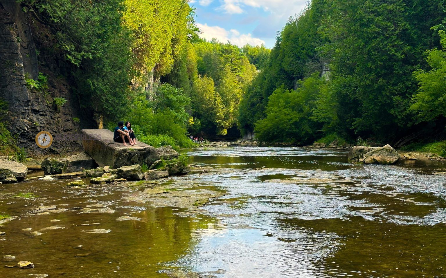
## Description Elora Gorge is one of Ontario’s most striking natural attractions, known for its steep limestone cliffs, fast-moving Grand River scenery, and a landscape that feels more dramatic than most visitors expect from southern Ontario. The gorge is part nature preserve, part outdoor recreation area, and part classic day-trip destination. People come for the views, the trails, the river access, and the feeling of standing in a place where water has carved a deep, narrow route through rock over a very long span of time. What makes Elora Gorge memorable is its contrast. The surrounding region is gently rural and easygoing, but the gorge itself is rugged and visually intense. When you stand on the edge and look down, the river appears surprisingly powerful as it moves through the canyon-like setting. The rock walls, tree cover, and water together create a scene that feels almost larger than life for a place that is relatively easy to access from nearby towns and cities. It is the kind of landscape that immediately rewards anyone who likes geology, photography, hiking, or simply being outdoors. One little-known fact about the area is how much its shape influences the mood of the visit. Even short walks feel more memorable because the viewpoint changes quickly from forest to cliff edge to river corridor. Another detail many visitors appreciate only after arriving is how seasonally different the gorge can feel. In spring, the river runs energetically and the foliage is fresh. In summer, the greens are dense and the area becomes a prime outdoor destination. In autumn, the cliffs and trees around the gorge can create a particularly vivid palette. Winter visits are quieter and more austere, but they can also be beautiful in a stark, sculptural way. Elora Gorge is also appealing because it can satisfy different travel styles. A casual visitor can enjoy the scenery and take a short walk, while a more active traveler can turn the visit into a longer outdoor outing. The gorge is one of those places where people often arrive with modest expectations and leave impressed by how photogenic and substantial it feels. ## Location Elora Gorge is in Ontario, Canada, near the village of Elora and within reach of the wider Waterloo Region and Wellington County area. The gorge is associated with the Grand River and is close enough to several southwestern Ontario cities to function as a realistic day trip. For many travelers, the easiest way to visit is by car, since that gives the most flexibility for parking, timing, and combining the gorge with nearby Elora village or other regional stops. If you are driving from Toronto, Kitchener-Waterloo, Guelph, or nearby communities, the route is straightforward enough for a day outing. Public transit is usually less convenient, so road travel is the most practical option for most visitors. Once you arrive, the experience is mostly about walking, looking, and choosing how active you want to be. If you are planning a fuller outdoor day, it makes sense to pair the gorge with village cafés, local shops, or other conservation-area activities in the surrounding region. ## Tips Wear footwear that can handle uneven paths and potentially muddy or damp ground. The gorge is beautiful, but it is not a place where fashionable footwear matters more than stability and comfort. If you want photos from scenic viewpoints, take your time and be cautious near edges and steep sections. The views are worth slowing down for, and safety should always come first. Check conditions before you go. Water levels, trail conditions, and seasonal access can change the experience significantly. A gorge that looks calm in one season can be much more energetic in another, and some areas may be better suited to certain weather conditions. If you are visiting with children, choose routes and viewpoints that match their energy and attention span. Bring water, snacks, and weather-appropriate layers. The gorge can feel cooler or windier than the nearby town, and you may spend more time outside than planned once you start enjoying the scenery. If you are interested in photography, morning and late afternoon are usually the best times for softer light. Consider making time for Elora village as well. The gorge is the headline attraction, but the surrounding area often makes the trip more satisfying. Many visitors find that pairing the natural site with a meal or wander in town creates the most balanced experience. ## Conclusion Elora Gorge is one of Ontario’s most rewarding scenic escapes, offering dramatic geology, outdoor recreation, and easy access from nearby communities. It is a strong choice for travelers who want nature without a complicated journey. ## FAQ ### Is Elora Gorge good for a quick visit? Yes. Even a short stop can be worthwhile if you want a scenic view and a brief walk. If you have more time, though, the gorge becomes much richer because you can explore the trails and surrounding area more fully. ### Is it suitable for families? It can be, provided you choose paths and viewpoints that fit your group’s comfort level. Families should pay close attention near steep edges and areas with uneven terrain. ### What is the best season to visit? There is no single best season, because each one has a different appeal. Spring and autumn are especially attractive for scenery, while summer is popular for outdoor activity and longer visits. ### Do I need to be an experienced hiker? No. There are options for casual visitors as well as more active hikers. You can tailor the trip to your own pace and interests. ### Can I see the gorge without a long hike? Yes. The attraction is accessible enough that you can enjoy views and the setting without committing to a major hike, although walking deeper into the area gives a fuller experience. ## Links - [Wikipedia](https://en.wikipedia.org/wiki/Elora_Gorge_Conservation_Area)
GemVoyage Team • World