GemVoyage Team • World
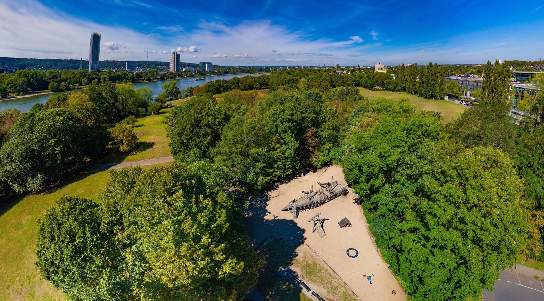
The park stands out because of its scale and composition. Broad open areas give it a relaxed, spacious feeling, while the presence of water and planted sections creates enough visual interest to keep a long walk engaging. One little-known fact is that the park was shaped by a major landscape design approach rather than emerging as a simple leftover green area, which explains why it feels so intentional and balanced. Another is that it works especially well in different weather conditions: sunny days bring picnic energy and wide horizons, while overcast days make the water and greenery feel especially calm.
Visitors often appreciate that Rheinaue Park feels lived-in rather than overly staged. People come here to walk, cycle, picnic, exercise, or spend time with family and friends. That mixed use gives the park a stable, local rhythm. It is not an attraction you rush through. It is a place that rewards taking your time, noticing how people use the space, and choosing your own pace.
The park is also useful for travelers who want an easy outdoor break without a complicated plan. After time in Bonn’s museums, old town, or riverfront, Rheinaue offers a reset. You can settle into a bench, cross open lawns, follow a trail near the water, or simply enjoy the change of scale from city streets to open parkland. It is the sort of place that may not dominate a guidebook cover but ends up becoming one of the most restful parts of a trip.
The easiest way to reach the park is by local public transport, bicycle, or car depending on where you start in the city. Because Bonn is relatively manageable, many visitors find that a bike or short transit ride works especially well. The park’s openness means that once you arrive, you can decide how long or how far you want to walk without needing a rigid route.
If you are planning a relaxed visit, choose good weather and give yourself time to move slowly. The park is best experienced as a place for lingering rather than ticking off sights.
Discover more hidden gems you might love.
Ottawa
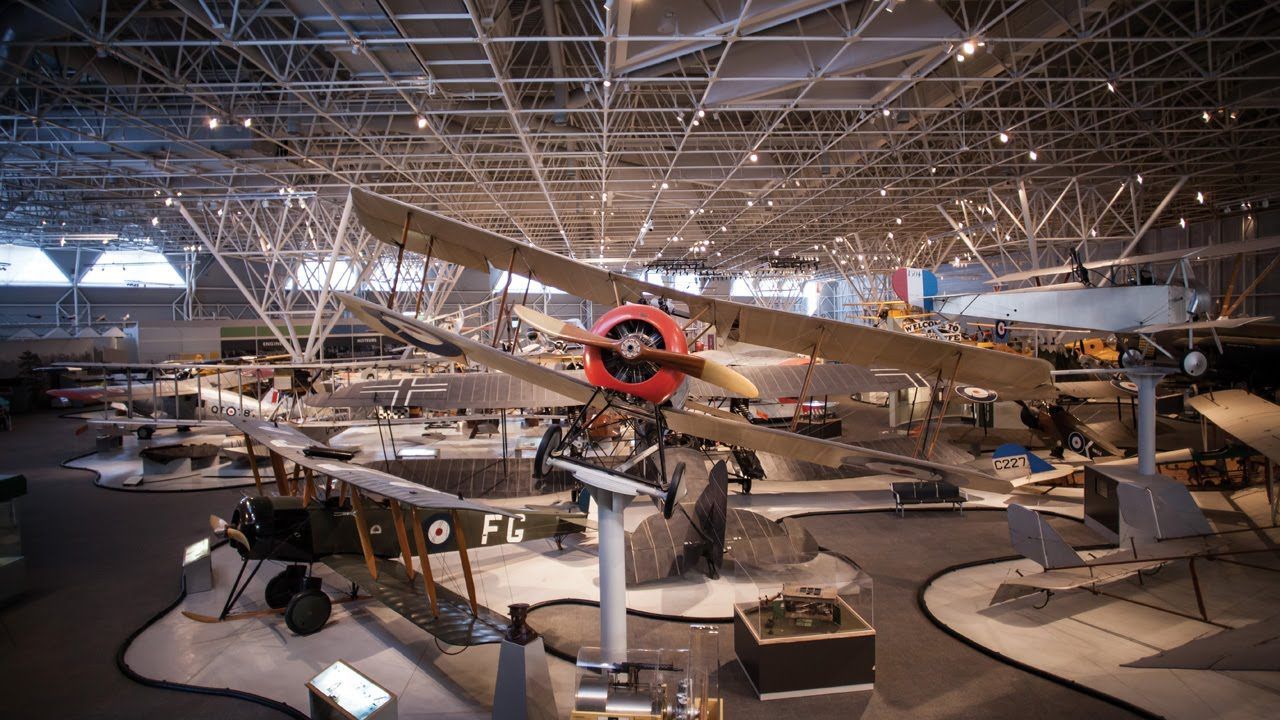
## Description The **Canada Aviation and Space Museum**, located in **Ottawa, Ontario**, is one of the most comprehensive aviation museums in the world and the premier institution of its kind in Canada. It showcases the country’s rich history of flight and space exploration, from the earliest biplanes to cutting-edge spacecraft technology. The museum’s vast collection includes **more than 130 aircraft and artifacts** representing civil, military, and experimental aviation. Visitors can see iconic planes such as the **Avro Arrow**, the **Silver Dart** (Canada’s first powered aircraft), and **Second World War fighters** like the **Spitfire** and **Hurricane**. There’s also an impressive section dedicated to **Canadian contributions to space exploration**, including displays about the **Canadarm**, **satellite technology**, and the role of Canadian astronauts in international missions. What makes the museum unique is its **hands-on, immersive experience**. Guests can climb into the cockpits of select aircraft, take guided tours of the restoration hangars, or even book a **real sightseeing flight** over Ottawa in a vintage **Waco UPF-7 biplane** (available seasonally). Interactive exhibits explain the physics of flight and the engineering challenges behind space travel, making it an engaging experience for visitors of all ages. A lesser-known fact is that the museum sits on the site of a **former Royal Canadian Air Force base**, and its origins date back to **1964**, when the National Aeronautical Collection was established. Another little-known feature is the **Living History program**, where retired pilots and engineers volunteer to share personal stories about the aircraft they flew or maintained — adding a deeply human dimension to the experience. ## Location The **Canada Aviation and Space Museum** is located at **11 Aviation Parkway**, in **Ottawa, Ontario, Canada**. It sits along the **Ottawa River**, just **10 minutes northeast of downtown Ottawa** and close to the **Rockcliffe Airport**. To get there: * **By car:** Take the **Aviation Parkway** from the city center; parking is available on-site for a small fee. * **By public transport:** OC Transpo bus routes connect from downtown Ottawa to stops near the museum (check current schedules before traveling). * **By bike or on foot:** The scenic **Ottawa River Pathway** leads directly to the museum for those enjoying a leisurely ride or walk. The museum’s location offers not only history and technology but also beautiful natural surroundings, making it a great addition to a full day of sightseeing in the capital. ## Tips * **Plan 2–3 hours for your visit:** The collection is large, and the interactive displays deserve time to explore. * **Check for special exhibitions:** The museum frequently hosts temporary displays, from space robotics to women in aviation. * **Book the biplane ride early:** The **Waco biplane experience** is a highlight for many visitors and sells out quickly, especially in summer. * **Visit with children:** The **Kids’ Zone** and interactive simulators make it family-friendly and educational. * **Photography:** Cameras are welcome — you can take stunning shots of aircraft interiors and panoramic hangar views. * **Combine with nearby attractions:** The **Canada Science and Technology Museum** and **Rideau Hall** are nearby for a full day of exploration. * **Visit in winter:** Indoor exhibits make it a great year-round attraction, ideal for cold or rainy days in Ottawa. ## Conclusion The **Canada Aviation and Space Museum** is more than a collection of aircraft — it’s a journey through Canada’s technological spirit, courage, and imagination. From early bush pilots who connected remote regions to astronauts who ventured beyond Earth’s atmosphere, the museum celebrates the nation’s boundless drive to explore. Whether you’re an aviation enthusiast, a history lover, or simply curious about humanity’s quest to fly, this Ottawa landmark offers an inspiring and educational experience that soars above expectations. ## FAQ **1. When was the museum founded?** The museum was established in **1964** as the National Aeronautical Collection and became the **Canada Aviation and Space Museum** in **1982**. **2. What are the museum’s main highlights?** Key attractions include the **Avro Arrow**, **Silver Dart**, **WWII aircraft**, **Canadarm**, and the **space exploration gallery**. **3. Is it suitable for children?** Yes, the museum is very family-friendly, featuring hands-on activities, simulators, and a dedicated **Kids’ Zone**. **4. How long should I spend there?** Most visitors spend **2 to 3 hours**, though aviation enthusiasts may want to stay longer. **5. Is there parking available?** Yes, there is ample on-site parking for a small daily fee. **6. Can I take a real flight?** Yes, visitors can book **sightseeing flights** in a vintage **Waco UPF-7 biplane** during the warmer months. **7. Is it open year-round?** Yes, the museum is open throughout the year, though operating hours may vary seasonally. ## Links * [Ottawa Tourism – Aviation and Space Museum](https://www.ottawatourism.ca)
GemVoyage Team • World
Algeria
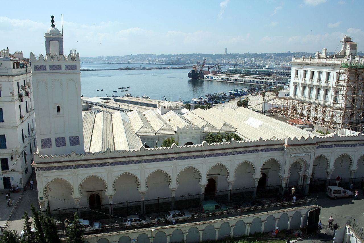
## Description Djamaa El Kbir Mosque, known in Arabic as الجامع الكبير الأثري, is one of the oldest and most historically significant mosques in Algeria. Built in 1097 during the Almoravid dynasty, it stands as a powerful reminder of Algiers’ deep Islamic and Mediterranean roots. Unlike more monumental later mosques, Djamaa El Kbir is admired for its restrained elegance, spiritual atmosphere, and architectural authenticity rather than sheer scale. What makes Djamaa El Kbir truly unique is its remarkable continuity. For more than nine centuries, the mosque has remained an active place of worship, surviving earthquakes, invasions, and centuries of urban transformation. Its minaret, added in the 14th century during the Zayyanid period, is one of the oldest in Algiers and features beautifully carved stone decoration that subtly blends Andalusian and Maghrebi styles. A little-known fact is that the mosque was built using spolia—reused columns and materials from earlier Roman structures—linking Islamic Algiers to its ancient past. Another lesser-known detail is that the mosque once formed part of a much larger religious and educational complex serving the Casbah community. Djamaa El Kbir is not only an architectural treasure but also a living symbol of faith, scholarship, and continuity in Algerian history. ## Location Djamaa El Kbir Mosque is located in **Algeria**, in the **Algiers Province**, within the city of **Algiers**. It stands in the historic Casbah district, close to the old harbor and not far from the Ketchaoua Mosque and other major landmarks of the old city. The mosque is easily accessible by foot if you are exploring the Casbah. Visitors can also reach the area by taxi or public transport from central Algiers. The nearest metro stations and bus routes serve the lower Casbah area, from where the mosque is a short walk. Due to narrow streets and limited parking, walking or using public transport is the most practical option. ## Tips * Dress modestly, as Djamaa El Kbir is an active place of worship. * Visit outside of prayer times if you wish to explore quietly and observe architectural details. * Photography may be restricted inside, so always ask permission before taking photos. * Take time to admire the minaret’s stone carvings, which are among the mosque’s most distinctive features. * Combine your visit with a walk through the Casbah to gain deeper historical context. * Consider visiting with a local guide to better understand the mosque’s architectural and historical significance. ## Conclusion Djamaa El Kbir Mosque is a rare and precious link to Algeria’s medieval Islamic past. Its simplicity, age, and continued religious function make it a deeply meaningful site, offering visitors a quiet but powerful insight into the spiritual and historical heart of Algiers. ## FAQ **When was Djamaa El Kbir Mosque built?** The mosque was built in 1097 during the Almoravid period. **Is Djamaa El Kbir still used for prayer?** Yes, it remains an active mosque and serves the local community daily. **Can non-Muslims visit the mosque?** Access may be limited to certain areas, and visitors should be respectful of religious practices. **How long does a visit take?** Most visits last 20 to 40 minutes, depending on access and interest. **Is there an entrance fee?** No, entrance is generally free, though donations may be welcomed. ## Links * [The Mosque's wiki page](https://en.wikipedia.org/wiki/Djamaa_el_Kebir)
GemVoyage Team • World
Cairo
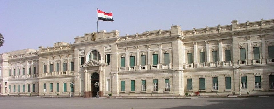
## Description The **Abdeen Palace Museum (متحف قصر عابدين)** is one of Cairo’s most magnificent historical landmarks and a must-see for lovers of history, architecture, and royal treasures. Constructed in the late 19th century under the orders of **Khedive Ismail**, the palace served as the royal residence for Egypt’s rulers from 1874 until 1952, when the monarchy was abolished. Today, it is both a functioning presidential palace and a museum complex that showcases the grandeur of Egypt’s royal past. What makes Abdeen Palace unique is its dual function: part of the palace remains an official seat of the presidency, while the museum sections are open to the public. The museum houses vast collections of weapons, medals, diplomatic gifts, rare manuscripts, and even an elaborate array of clocks and watches. The **Arms Museum** and **Medals Museum** are particular highlights, revealing not just Egypt’s history but also its connections to other nations. A lesser-known fact is that Abdeen Palace is one of the largest palaces in the world, with over **500 rooms**, though only a fraction is open to visitors. Another interesting detail is that the palace survived several periods of turmoil, including the 1952 revolution, and still stands as a symbol of both Egypt’s royal heritage and its modern political history. ## Location Abdeen Palace is located in **Downtown Cairo**, the capital of **Egypt**, in the **Cairo Governorate**. It sits in the Abdeen district, east of Tahrir Square, making it accessible from many of Cairo’s central landmarks. To get there, visitors can take a taxi, Uber, or public transport to the Abdeen area. The nearest metro stop is **Mohamed Naguib Station** on Cairo’s Metro Line 2, from which the palace is a short walk. Because Cairo traffic can be hectic, traveling by metro or planning visits during less busy hours is recommended. ## Tips * **Check opening hours:** The museum is usually open daily except Fridays, but hours can vary. Confirm before your visit. * **Wear comfortable shoes:** The palace is vast, and exploring its multiple museum wings requires a lot of walking. * **Photography rules:** Photography may be restricted in certain sections, so check guidelines upon entry. * **Hire a guide:** To appreciate the full historical context, consider hiring a local guide or audio guide. * **Combine with other attractions:** The palace’s downtown location makes it easy to pair with nearby sites like Tahrir Square, the Egyptian Museum, or Khan El Khalili bazaar. * **Respect security regulations:** Since it remains a presidential palace, expect thorough security checks at the entrance. ## Conclusion The **Abdeen Palace Museum** is more than just a royal residence—it is a treasure house of Egypt’s modern history. With its lavish architecture, rare collections, and continuing role in national life, it provides visitors with a deeper understanding of Egypt’s transition from monarchy to republic. For anyone exploring Cairo, Abdeen Palace offers a captivating mix of politics, culture, and opulence. ## FAQ **1. When was Abdeen Palace built?** It was commissioned by Khedive Ismail and completed in 1874, designed with European architectural influences. **2. How many museums are inside Abdeen Palace?** The palace contains several specialized museums, including the Arms Museum, Medals Museum, Silver Museum, and Historical Documents Museum. **3. Is the palace still used today?** Yes, part of Abdeen Palace is still used by the Egyptian Presidency for official functions, while the museum sections are open to the public. **4. How much time should I plan for a visit?** Plan at least 2–3 hours to explore the various museum wings at a comfortable pace. **5. Is photography allowed inside?** Photography rules vary; in many areas it is restricted or requires a permit. Always check before taking photos. **6. What’s the best way to get there?** The metro is a convenient choice, with Mohamed Naguib Station nearby. Otherwise, taxis and ride-hailing services are widely available in Cairo. ## Links * [Egyptian Ministry of Tourism](https://egypt.travel)
GemVoyage Team • World
Plateliai
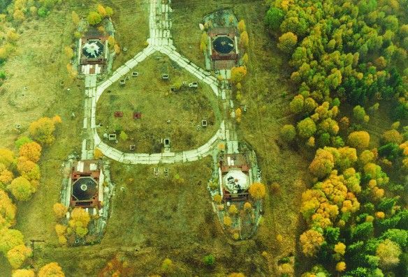
## Description The Plokštinė missile base, now preserved as the Cold War Museum near Plateliai, offers a rare and visceral encounter with twentieth-century strategic history. The site is a remarkably intact example of Soviet military engineering: deep underground launch tunnels, reinforced command bunkers, and surface infrastructure that hint at a wartime readiness now frozen in time. Unlike many museums that reconstruct events with replicas, Plokštinė retains original concrete, rusted metalwork, and patched wiring—materials that convey the scale and urgency of deterrence planning. What makes Plokštinė particularly compelling is its layered storytelling. Exhibits interweave technical descriptions of missile systems and launch protocols with human-scale narratives—photos of personnel, uniforms, diaries and municipal records that emphasize the lived experience of those stationed there. Guided tours often highlight operational details (how crews were rotated, how shelters were maintained) while reflecting on the broader geopolitical context: why land-based missile sites mattered to Soviet strategy and how their presence reshaped local communities. Conservation at Plokštinė has a museum-like rigor: lighting and interpretation are carefully placed to preserve fragile surfaces while enabling visitors to read inscriptions and see equipment. In the tunnels, the stone and concrete surfaces absorb sound, producing an almost cathedral-like hush that encourages reflection. The juxtaposition of heavy engineering and intimate domestic artifacts—the letter folded inside a pocket, a tea set on a service table—creates a human counterpoint to the site's strategic purpose. ## Location Plokštinė sits in western Lithuania near the small town of Plateliai in the Plungė district (Telšiai County), set against the pine and mixed-forest landscapes of Žemaitija National Park. The remoteness is part of the site’s character: the base was intentionally sited away from population centers, hidden by terrain and vegetation. Visitor research note: Scholars and Cold War enthusiasts should contact the museum ahead of time if they plan to consult archival materials or request deeper access for research purposes. Curators sometimes facilitate focused visits or point researchers toward local archives and oral-history resources that provide fuller context. How to get there: the most practical way to visit is by car, with the drive from Plateliai or Plungė taking under an hour depending on route and conditions. Local tour operators in Plateliai sometimes offer organized visits, which can include transport and guided interpretation. Public transport is sporadic — taxis from Plateliai or Plungė are the pragmatic alternative for visitors without private vehicles. Be mindful that signage outside the immediate museum area can be limited; bring offline maps or GPS coordinates when traveling. ## Tips - Book guided tours in advance when possible; on-site staff provide technical context and safety briefings that enhance understanding. - Dress for underground conditions: temperatures in tunnels are lower and the ground can be uneven and damp; sturdy shoes and a light jacket are recommended. - Respect restricted areas and posted rules; some sections may be closed to preserve sensitive structures or materials. - Photography: allowed in many parts, but check signage for restrictions in operational or fragile zones; avoid flash where plaster or pigments may be vulnerable. - Combine the visit with natural attractions: Plateliai Lake and Žemaitija National Park are nearby and make for a well-rounded day trip. - Bring water and snacks, as amenities near the site are limited; local cafes in Plateliai provide a pleasant break before or after a tour. ## Conclusion The Plokštinė Cold War Museum is a vivid public history site where engineering, geopolitics, and local memory intersect. It invites visitors to slow down and consider the practical technologies of deterrence alongside the human routines that sustained a military outpost. For scholars, photographers, and travelers interested in Cold War heritage, Plokštinė offers an uncommonly honest look at a world that once revolved around secrecy and rapid readiness. ## FAQ Q: Can visitors go inside the missile tunnels? A: Yes—guided tours typically include accessible sections of the underground complex. Access depends on safety conditions and conservation work, so check current availability and any age or mobility restrictions before you travel. Q: How long should I plan for a visit? A: Plan for at least two hours to experience the museum and tunnels at a relaxed pace; a guided tour plus time to read exhibits and explore surface ruins may take three hours. Q: Are tours available in English? A: Some tours and interpretive materials are available in English, but availability varies. Contact the museum or local tourism offices for the current language options and to request an English-speaking guide. Q: Is Plokštinė suitable for children? A: Older children and teens typically find the site fascinating, especially with a guide to explain technical details. Very young children may find confined spaces and sombre themes unsettling; consider the itinerary and their comfort. Q: Is the site accessible for visitors with reduced mobility? A: The underground and older structures have limited accessibility due to stairs, uneven surfaces, and narrow corridors. Visitors with mobility concerns should contact the museum ahead of time to discuss options and view accessible areas. ## Links - [Plokštinė missile base / Cold War Museum](https://coldwarsites.net/country/lithuania/plokstine-missile-base-museum-of-cold-war-plateliai/)
GemVoyage Team • World
Mexico City
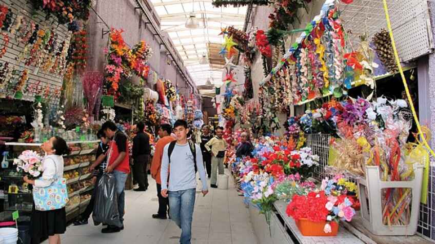
## Description La Merced Market is one of **Mexico City’s largest and most iconic traditional markets**, a bustling labyrinth of colors, aromas, and flavors that captures the essence of everyday Mexican life. For centuries, it has served as a vital trading hub where locals shop for fresh produce, meats, spices, textiles, and even artisanal crafts. Today, it stands as both a cultural landmark and a culinary paradise, drawing in visitors eager to experience authentic Mexican street food and local traditions. What makes La Merced unique is its **immense size and variety**—it is estimated to cover more than **400,000 square meters** and contains thousands of stalls spread across multiple buildings and outdoor areas. Here, you can find everything from exotic fruits and chilies to traditional sweets and handmade kitchen tools. A little-known fact is that La Merced’s history dates back to the **16th century**, when it served as an indigenous trading ground after the Spanish conquest. Another fascinating detail is that the market is considered one of the **most diverse food hubs in Latin America**, with vendors selling ingredients that reflect Mexico’s rich cultural fusion, from pre-Hispanic staples to colonial-era imports. ## Location La Merced Market is located in **Mexico City, Mexico**, within the **Venustiano Carranza borough**, just east of the city’s historic center. Its exact location makes it an easy stop for anyone exploring the heart of the capital. ### Recommendation on How to Get There The most convenient way to reach La Merced is by **Mexico City Metro**. Simply take **Line 1 (the pink line)** and get off at **La Merced Station**, which connects directly to the market area. Taxis and rideshare apps like Uber are also widely available, but due to traffic in the historic center, the metro is often the fastest and most affordable option. If you are walking from the **Zócalo**, the market is about 20 minutes away on foot. ## Tips To make the most of your visit to La Merced Market, here are some useful tips: * **Go Early**: Arriving in the morning lets you see the market at its most vibrant and ensures the freshest food options. * **Bring Cash**: Most vendors do not accept cards, so carry small bills and coins for easy purchases. * **Sample the Street Food**: Try classics like **tacos de suadero, tlacoyos, fresh fruit juices, and tamales**. * **Dress Comfortably**: The market is vast and can get crowded, so wear light clothing and comfortable shoes. * **Be Mindful of Safety**: As with any large urban market, keep an eye on your belongings and avoid flashing valuables. * **Explore Beyond Food**: The market also offers textiles, pottery, household goods, and religious items worth browsing. * **Hire a Guide (Optional)**: If it’s your first visit, consider joining a guided food tour for a deeper understanding of the market’s history and hidden gems. ## Conclusion La Merced Market is not just a shopping destination—it’s a cultural experience that immerses visitors in the **authentic spirit of Mexico City**. With its overwhelming variety of goods, historic roots, and unbeatable street food scene, it is a must-visit for anyone who wants to discover the daily life and flavors of Mexico beyond the typical tourist spots. ## FAQ **1. What is La Merced Market famous for?** It is famous for its massive size, wide variety of products, and authentic Mexican street food. **2. What are the market’s opening hours?** La Merced is generally open **every day from early morning until late evening**, though hours may vary by stall. **3. Is La Merced safe for tourists?** Yes, it’s generally safe if you remain cautious—stick to the busier areas, keep your belongings secure, and avoid visiting at night. **4. Can I find vegetarian or vegan food options at La Merced?** Yes, there are many vegetarian-friendly dishes such as tlacoyos, quesadillas with squash blossoms, and fresh fruit juices. **5. How does La Merced compare to other markets in Mexico City?** While markets like Coyoacán or San Juan are smaller and more tourist-oriented, La Merced offers a raw, authentic, and immersive local experience. **6. Is it worth visiting with kids?** Yes, though parents should be prepared for large crowds and keep children close by in the busier sections. ## Links * [Mexico City Official Tourism Website](https://mexicocity.cdmx.gob.mx/)
GemVoyage Team • World
Tokyo
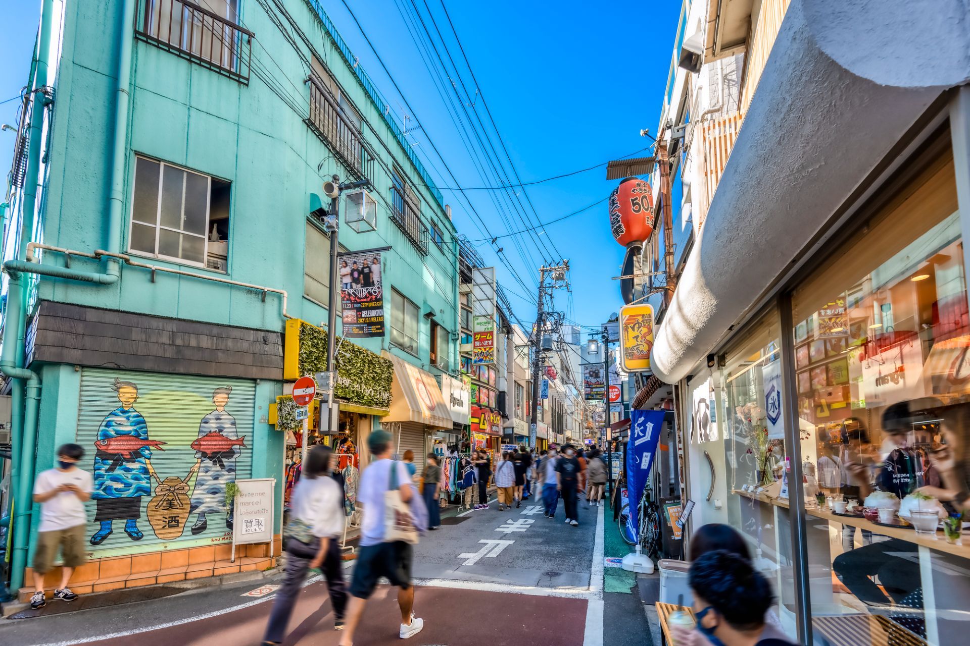
## Description Shimokitazawa is one of Tokyo's most beloved neighborhoods for travelers who want a creative, youthful, and slightly offbeat urban experience. Known for its indie shops, vintage fashion, small music venues, cafes, bars, and relaxed street culture, the area feels like a counterpoint to the polished intensity of central Tokyo. It is dense enough to feel exciting but compact enough to explore without stress, which makes it ideal for wandering. The neighborhood's appeal lies in its mix of everyday life and subculture. You can spend an afternoon browsing record stores, secondhand clothing shops, zines, and design goods, then stop for coffee or a casual meal in a tiny restaurant tucked into a side street. The area has long been associated with theater, music, and youth culture, so even when it is busy it retains an unmistakable creative identity. Many visitors describe it as a place where Tokyo becomes more approachable and personal. One little-known fact is that Shimokitazawa's reputation as a vintage hub grew gradually over decades, rather than through a single development plan, which gives its retail landscape an organic feel. Another is that the neighborhood has been shaped by rail infrastructure and urban redevelopment, yet it still preserves a strong sense of small-scale community in its alleys and side streets. That balance between change and continuity is central to its character. The streets themselves are part of the experience. Unlike hyper-structured shopping districts, Shimokitazawa encourages detours. A turn into a narrow lane may reveal a tiny jazz bar, an art space, or a cafe with a deliberately handmade interior. This makes the neighborhood especially rewarding for repeat visits, because the pleasure comes from discovering layers rather than checking off landmarks. Food is another reason to stay longer than expected. Shimokitazawa has everything from casual ramen and curry to dessert shops and specialty coffee. The density of places to eat means you can shape the day around browsing, resting, and browsing again. In the evening the district softens into a social district, with bars and live venues drawing a crowd that is varied but usually relaxed. For travelers who want a neighborhood that captures a more intimate and creative side of Tokyo, Shimokitazawa is an excellent choice. It is stylish without feeling exclusive and lively without feeling overwhelming. That combination is rare, and it is what keeps the area high on many repeat visitors' lists. ## Location Shimokitazawa is a neighborhood in Setagaya, Tokyo, Japan, located in the western part of the inner city. It is known for the station area and the streets that radiate from it. The easiest way to get there is by train, especially via the Odakyu Line or Keio Inokashira Line. Once you arrive, the district is best explored on foot. Because the neighborhood is compact, you can comfortably combine shopping, food, and nightlife in one visit. ## Tips Go without a rigid plan. The neighborhood is best enjoyed through spontaneous exploration. Visit both daytime and evening if you can. Daytime is better for shopping, while evening brings a more social atmosphere. Bring cash or a card that works widely in Japan, since smaller shops may have different payment preferences. If you are interested in vintage fashion, be prepared to spend time. Good finds often take patience. Look for smaller side streets rather than staying only near the station exits. Use Shimokitazawa as a half-day or full-day stop, depending on how much you want to browse and eat. ## Conclusion Shimokitazawa offers one of Tokyo's most distinctive neighborhood experiences, blending indie culture, vintage shopping, and relaxed urban energy in a compact and walkable district. ## FAQ ### What is Shimokitazawa famous for? It is famous for vintage clothing, independent cafes, small live music venues, theater, and a creative neighborhood atmosphere. ### Is Shimokitazawa worth visiting for first-time travelers to Tokyo? Yes, especially if you want a more local and youthful district beyond the major sightseeing areas. ### How much time do I need there? At least half a day, though many visitors stay longer because of the shopping and food options. ### Is Shimokitazawa good for nightlife? Yes, but it is a more relaxed nightlife scene than the biggest entertainment districts in Tokyo. ## Links - [Shimokitazawa](https://en.wikipedia.org/wiki/Shimokitazawa) - [Tokyo tourism](https://www.gotokyo.org/en/)
GemVoyage Team • World

Comments