GemVoyage Team • World
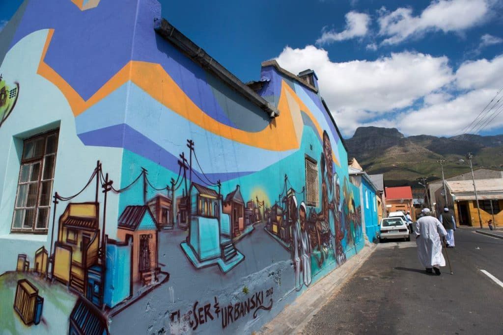
Unlike a single museum collection, street art in Woodstock changes constantly. Some murals are large and highly detailed, others are quick, expressive statements. That variety is part of the appeal. Visitors can see work that reflects social issues, community pride, satire, environmental themes, and the evolving face of Cape Town itself. Because the art lives on real buildings and infrastructure, the setting gives it an edge that is hard to replicate indoors. The texture of peeling walls, warehouse façades, and narrow streets adds meaning to the work and makes photographs feel more grounded and authentic.
One little-known aspect of Woodstock’s street art scene is how strongly it reflects the neighborhood’s broader reinvention. The area has become one of Cape Town’s most recognizable creative districts, but many of the artworks also respond to the tensions that come with urban change, displacement, and heritage. Another detail that visitors sometimes miss is that the best experience often comes from moving slowly and looking above eye level as well as at street level. Murals are not limited to obvious walls; some of the most memorable pieces appear in alleys, on shutter doors, or on the sides of buildings that you might pass too quickly if you are not paying attention.
The result is a destination that rewards curiosity. Woodstock Street Art is not polished in the traditional tourist sense, and that is exactly why it feels alive. It offers a way to understand Cape Town as a city of layers, where creativity and social commentary coexist with everyday street life. For travelers who like walking neighborhoods that feel both artistic and real, it is one of the city’s most compelling stops.
The most practical way to explore is usually on foot with a map, a local guide, or a curated street art walk. Some travelers prefer joining a guided tour because guides can explain the meaning behind individual murals and help visitors navigate the area more confidently. Taxis and rideshares can drop you off at a convenient starting point, but the actual appreciation comes from walking slowly. If you are comfortable with urban exploration, pairing your visit with a café stop or market break in Woodstock can make the outing feel more complete.
Consider a guide if you want context. Some murals are visually striking on their own, but the stories behind them make the experience richer. A guide can also help you notice pieces that blend into the surroundings or point out artists and themes you might otherwise miss. If you prefer to explore independently, spend extra time reading plaques, following side streets, and looking for smaller works in doorways and corners.
Dress practically. Comfortable shoes matter because you will likely walk more than you think. A light bag, water, and sun protection are wise choices, especially during warmer months. It is also sensible to stay aware of your surroundings and follow local advice about which streets are most convenient to explore.
Combine the visit with food or coffee. Woodstock has a creative food scene, and stopping for a meal can make the district feel more approachable. Street art is at its best when it becomes part of a broader neighborhood experience rather than a quick photo stop. The more time you give Woodstock, the more the neighborhood’s layered personality becomes visible.
Discover more hidden gems you might love.
Milan
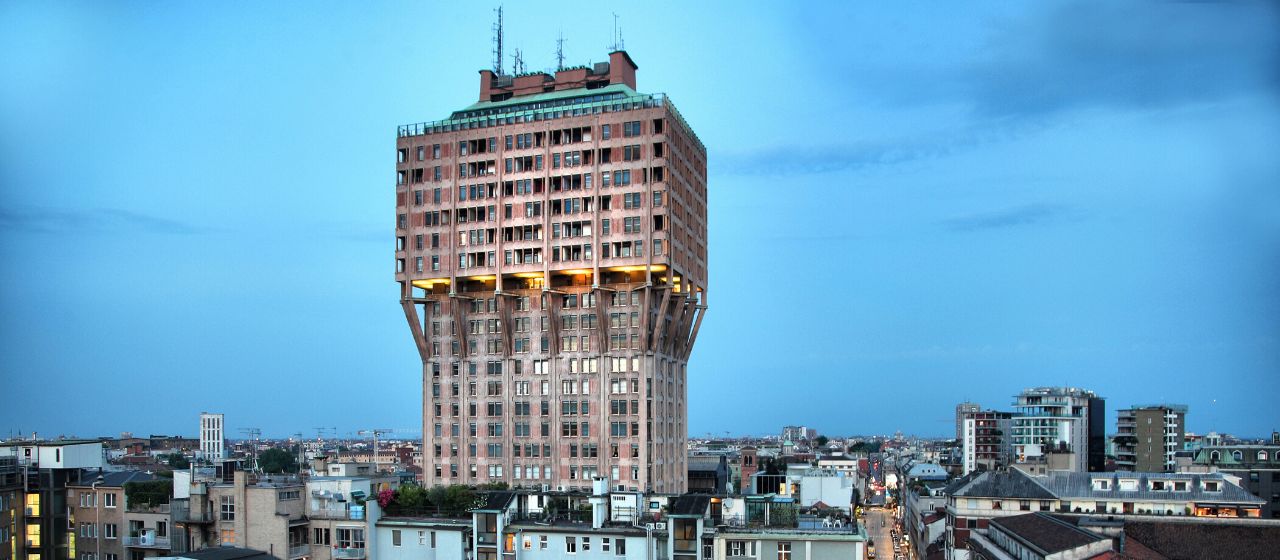
## Description The **Torre Velasca** is one of Milan’s most recognizable—and most controversial—architectural landmarks. Rising sharply above the historic city center, this distinctive skyscraper challenges the visual harmony of Milan with a form that defies both traditional elegance and modernist simplicity. Completed in **1958**, Torre Velasca represents a bold experiment in **post-war Italian architecture**, blending **medieval visual references with modern structural engineering**. Designed by the prestigious **BBPR architectural collective** (Banfi, Belgiojoso, Peressutti, and Rogers), the tower was conceived during a period when Italy was rebuilding not only its cities, but its cultural identity after World War II. Rather than copying American glass skyscrapers, BBPR attempted to create a **uniquely Italian vertical building**, rooted in Milan’s historical skyline of towers, fortifications, and cathedrals. The most striking feature of Torre Velasca is its **mushroom-shaped profile**. The lower portion is slim and vertical, while the upper floors expand outward dramatically, creating the impression of a fortress suspended in midair. This unusual silhouette deliberately echoes the **medieval defensive towers** that once protected Italian cities. The exterior façade, with its exposed concrete ribs and reddish-brown cladding, reinforces the impression of strength and permanence rather than lightness or transparency. Functionally, the tower was built as a **mixed-use structure**, combining offices in the lower levels and residential apartments in the expanded upper portion. This dual function was innovative for its time and contributed to the tower’s distinctive form—wider upper floors were better suited for domestic layouts with larger windows and more light. Artistically, Torre Velasca sits in a unique position between **Brutalism, Rationalism, and Neo-Medievalism**. Some critics consider it awkward or aggressive, arguing that it clashes with Milan’s Renaissance and Gothic heritage. Others see it as a courageous refusal to submit to anonymous international modernism. Over time, what was once widely criticized has become a **symbol of intellectual resistance in architecture**, representing Milan’s willingness to experiment rather than imitate. A little-known fact is that one of the architects, **Gian Luigi Banfi**, died in a Nazi concentration camp during World War II, and the tower stands partly as a symbolic continuation of the group’s interrupted pre-war ambitions. Another lesser-known detail is that construction techniques used in Torre Velasca directly influenced **later Italian concrete tower projects** in the 1960s and 1970s, making it a reference point for generations of architects. Today, Torre Velasca remains fully functional and continues to divide opinion. To some, it is Milan’s “ugliest skyscraper.” To others, it is one of its most intellectually daring. What is beyond dispute is that the tower is an **unavoidable visual statement**, standing as a reminder that urban identity can be built not only on beauty, but also on creative risk. ## Location **Torre Velasca** is located in the **historic center of Milan**, just a short walk from several of the city’s most important landmarks. **City:** Milan **Region:** Lombardy (Lombardia) **Country:** Italy **District:** Centro Storico ### How to Get There: * **By metro:** * **Line M3 (Yellow Line)** to **Missori Station**, then walk 5 minutes. * **Line M1 (Red Line)** to **Duomo Station**, then walk about 10 minutes. * **By tram:** Multiple central tram lines stop near the tower. * **By foot:** Easily reachable from **Milan Cathedral (Duomo)**, the **University of Milan**, and **San Bernardino alle Ossa**. * **By taxi or ride-hailing apps:** Direct access is easy from anywhere in the city center. Its central location allows visitors to integrate Torre Velasca into almost any walking itinerary of historic Milan. ## Tips * **Best viewed from multiple distances:** The unusual shape is most striking when seen from both nearby streets and distant viewpoints. * **Combine with Duomo and University of Milan:** All are within easy walking distance. * **Do not expect interior tourism access:** The tower is primarily a **private residential and office building**. * **Photography works best at sunset:** Warm light highlights the tower’s textured concrete façade. * **Architecture-first attraction:** This site is most rewarding for visitors interested in **urban design and modern architecture**, not traditional sightseeing. * **Look for contrast:** Observe how the tower interacts visually with Gothic spires and Renaissance façades nearby. * **Read about its history before visiting:** Understanding its post-war context significantly enhances appreciation. ## Conclusion The **Torre Velasca** is not designed to impress everyone—and that is precisely its strength. As a bold post-war experiment, it challenges conventional ideas of beauty, heritage, and modernity within one of Europe’s most historically refined cities. Whether admired or criticized, the tower remains a defining symbol of Milan’s **architectural independence and intellectual courage**, proving that controversy can be as enduring as elegance. ## FAQ **1. Why is Torre Velasca so controversial?** Because its **fortress-like modern design sharply contrasts** with Milan’s classical skyline, dividing public opinion. **2. Can visitors go inside Torre Velasca?** No. It is mainly a **private residential and office building** and is not generally open to tourists. **3. Who designed Torre Velasca?** It was designed by the **BBPR architectural group**, one of Italy’s most influential post-war design collectives. **4. What architectural style does it represent?** It blends **Brutalism, Rationalism, and Neo-Medieval influences**, making it difficult to classify under a single style. **5. How tall is Torre Velasca?** It stands approximately **106 meters (348 feet)** tall. **6. Is Torre Velasca considered a protected building?** Yes. It is now recognized as an **important monument of 20th-century Italian architecture**. ## Links * [Wikipedia Page](https://en.wikipedia.org/wiki/Torre_Velasca)
GemVoyage Team • World
Tarasp
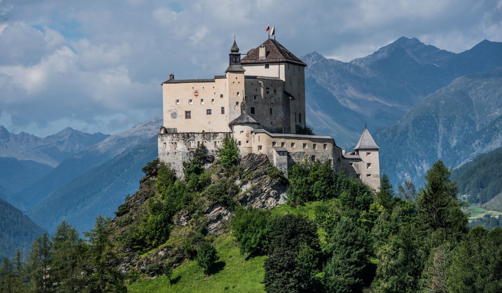
## Description Schloss Tarasp is one of Switzerland’s most impressive and best-preserved medieval castles, dramatically perched on a rocky hill overlooking the Lower Engadin Valley. With its imposing towers, thick stone walls, and commanding views, the castle feels like a scene straight out of a historical epic. Dating back to the 11th century, Schloss Tarasp has played a significant role in the region’s political and cultural history and remains a powerful symbol of the Engadin. What makes Schloss Tarasp truly unique is its combination of medieval architecture and refined interior artistry. While many castles focus mainly on defensive structures, Schloss Tarasp surprises visitors with richly decorated rooms, ornate furniture, and an exceptional collection of art and antiques. One little-known fact is that the castle houses a famous private organ, installed in the early 20th century, which is still used for concerts today. Another lesser-known detail is that the castle once belonged to industrialist August Lingner, the inventor of Odol mouthwash, who restored it extensively and transformed it into a cultural landmark. Today, Schloss Tarasp can only be visited through guided tours, which add depth and storytelling to the experience, making history come alive for visitors of all ages. ## Location Schloss Tarasp is located in **Switzerland**, in the **Graubünden** canton, within the **Lower Engadin** region. The castle stands above the village of Tarasp, near the town of Scuol, surrounded by alpine landscapes and mountain scenery. To get there, travelers can take a train on the Rhaetian Railway to **Scuol-Tarasp** station, which is well connected to other parts of Switzerland. From the station, local buses run toward Tarasp village, and from there a short uphill walk leads to the castle entrance. Visitors arriving by car can drive to Tarasp and park near the base of the hill, followed by a scenic walk up to the castle. ## Tips * Schloss Tarasp can only be visited on guided tours, so check tour times in advance and arrive early to secure a spot. * Wear comfortable shoes, as the walk up to the castle is steep and the interiors include uneven stone floors and stairs. * Photography may be restricted in certain rooms, so always follow the guide’s instructions. * Plan extra time to enjoy the panoramic views of the Engadin Valley from the castle grounds. * Combine your visit with a stop in nearby Scuol, known for its thermal baths and traditional Engadin architecture. * Tours are often offered in multiple languages, but availability may vary depending on the season. ## Conclusion Schloss Tarasp offers a rare and immersive journey into Switzerland’s medieval past, enriched by art, music, and stunning alpine scenery. Its dramatic setting, well-preserved interiors, and guided storytelling make it one of the most memorable castle visits in the country. ## FAQ **Do I need to book tickets in advance?** Advance booking is recommended, especially during summer and peak travel seasons, as tour sizes are limited. **Is Schloss Tarasp suitable for children?** Yes, guided tours are generally engaging for children, though very young kids may find the tour length challenging. **How long does a guided tour last?** Most guided tours last between 60 and 90 minutes. **Is the castle accessible for people with limited mobility?** Due to its medieval structure, access can be difficult for visitors with limited mobility. It is best to check accessibility details in advance. **When is the best time to visit Schloss Tarasp?** Late spring to early autumn is ideal, when the weather is mild and travel routes are fully accessible. ## Links * [Schloss Tarasp Information](https://www.myswitzerland.com/en-us/experiences/schloss-tarasp-chaste-da-tarasp/)
GemVoyage Team • World
Tokyo
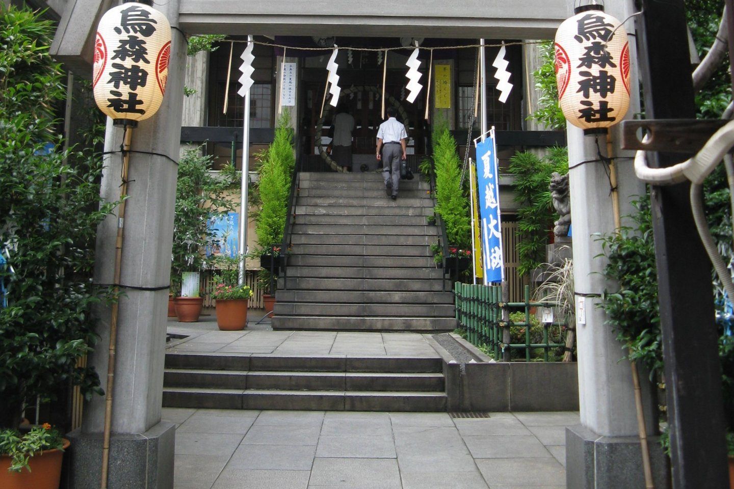
## Description **Karasumori Shrine (烏森神社)** is a small yet deeply symbolic Shinto shrine tucked into one of Tokyo’s most modern and fast-paced districts. Unlike large, monumental shrines surrounded by forests or expansive grounds, Karasumori stands out precisely because of its **contrast with its surroundings**. Encircled by office towers, restaurants, and neon-lit streets near Shimbashi, the shrine feels like a quiet spiritual pocket preserved inside the machinery of the modern city. The shrine is dedicated primarily to **Ame-no-Uzume-no-Mikoto**, a Shinto deity associated with joy, performance, and the arts, as well as protection from misfortune. Because of this, Karasumori Shrine has long been popular with **actors, entertainers, businesspeople, and office workers**, all of whom come to pray for success, smooth communication, and good fortune in their professional lives. What truly makes Karasumori Shrine unique is its **distinctive omamori (protective charms)**. These charms are unusually colorful, often featuring bright red, yellow, blue, and green threads rather than the subdued tones found at most shrines. According to shrine tradition, these colors represent protection from misfortune arriving from any direction. This detail is relatively unknown outside Japan and has helped the shrine develop a quiet but loyal following among locals. Another lesser-known fact is that Karasumori Shrine was originally located closer to Edo Castle but was moved to its current position during urban development. Despite its relocation, it retained strong ties to merchants and workers, which explains its enduring relevance in a business district rather than a residential or historical one. The shrine has also survived fires, earthquakes, and wartime destruction, making it a subtle symbol of resilience amid Tokyo’s constant transformation. Karasumori Shrine is not a place for grand ceremonies or long visits. Its value lies in **intimacy, symbolism, and continuity**, offering a moment of pause rather than spectacle. ## Location **Country:** Japan **Region:** Kantō **City:** Tokyo **Ward:** Minato **Area:** Shimbashi Karasumori Shrine is located just a short distance from Shimbashi Station, one of Tokyo’s major transportation hubs and a center for office culture and nightlife. ### How to Get There * **By train:** * JR Yamanote Line, Keihin-Tohoku Line, or Tokyo Metro Ginza Line to **Shimbashi Station**. From the Karasumori Exit, the shrine is a 2–3 minute walk. * **By subway:** * Toei Asakusa Line to Shimbashi Station, also within walking distance. * **On foot:** * Easily accessible if you are exploring central Tokyo districts such as Ginza or Shiodome. * **By taxi:** * A convenient option due to the shrine’s central location, though unnecessary given public transport access. ## Tips * **Visit during weekdays for atmosphere:** You will see office workers stopping by during lunch breaks or after work. * **Be respectful of space:** The shrine grounds are compact, and local worshippers come for quiet prayer. * **Purchase an omamori:** The colorful charms are the shrine’s most distinctive feature and make meaningful souvenirs. * **Avoid peak commute times:** Early morning and early evening can be crowded due to nearby train traffic. * **Short visit is sufficient:** 15–30 minutes is enough to appreciate the shrine fully. * **Photography is allowed, but discreet:** Avoid photographing people while they are praying. ## Conclusion Karasumori Shrine offers a rare glimpse into Tokyo’s spiritual life as it exists today, not as a preserved relic but as a living part of the urban routine. Small, understated, and symbolic, it rewards visitors who value authenticity and subtlety over grandeur. ## FAQ **1. Is Karasumori Shrine famous?** It is well-known among locals but relatively unknown to international tourists. **2. Is there an entrance fee?** No, entry is free. **3. How long should I spend there?** Around **15 to 30 minutes** is sufficient. **4. What is the shrine best known for?** Its colorful protective charms and prayers for career success and good fortune. **5. Is it suitable for first-time visitors to a Shinto shrine?** Yes, its small size makes it approachable and easy to understand. **6. Can I combine it with other attractions?** Yes, it pairs well with visits to Ginza, Shiodome, or nearby dining areas. ## Links * [Japan National Tourism Organization](https://www.japan.travel)
GemVoyage Team • World
Stockholm
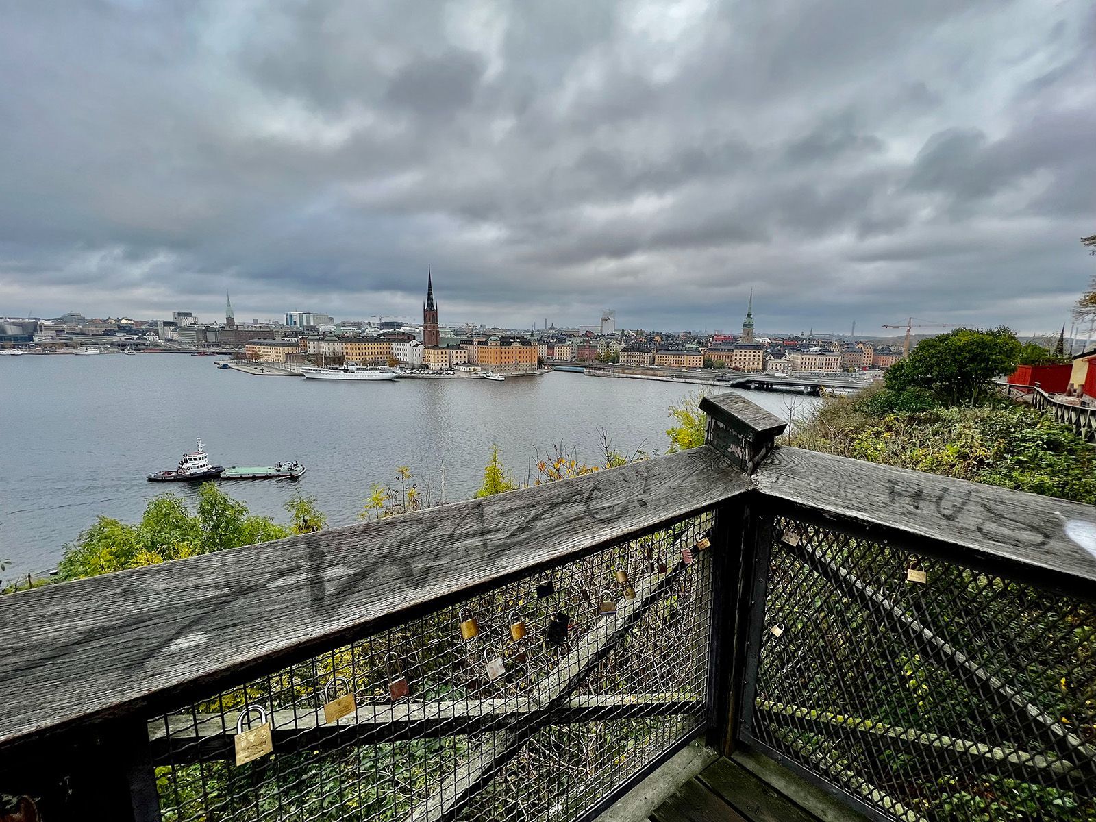
## Description Monteliusvägen is one of Stockholm’s most beloved viewpoint walks because it offers a remarkable amount of scenery for very little effort. Stretching along Mariaberget in Södermalm, the path gives visitors panoramic views over Riddarfjärden, City Hall, and the water and skyline that define Stockholm’s visual identity. It is a place where walking becomes part of the sightseeing itself, and where the city looks especially elegant in changing light. The viewpoint’s appeal lies in its mixture of accessibility and atmosphere. You do not need to climb a mountain or travel far from the center to get a memorable outlook. Instead, you can step into a residential and elevated part of the city and find a broad view that feels almost theatrical. One little-known fact is that Monteliusvägen is particularly admired by locals for how reliably it delivers a strong skyline view without the crowds associated with more obvious tourist stops. Another is that the path changes character with the seasons; winter can make the scenery crisp and graphic, while summer brings long, luminous evenings and a more relaxed mood. What also makes Monteliusvägen special is that it combines motion and pause. As you walk, the city opens and closes in layers. You might pass benches, low walls, and quiet residential details, then suddenly find a view that feels worthy of a postcard. That rhythm encourages visitors to slow down rather than rush through. It is a great place to arrive without a fixed plan, because the reward comes from both the walk and the destination. For photographers and casual visitors alike, the viewpoint is one of Stockholm’s most satisfying urban experiences. It captures the city’s relation to water, its elegant low-rise skyline, and its subtle balance between nature and urban form. A sunset visit can be particularly memorable, but the viewpoint works at many times of day because the geometry of the city and the water remains compelling even in flat light. ## Location Monteliusvägen is located on Mariaberget in Södermalm, Stockholm, Sweden, overlooking the waters of central Stockholm. It is very close to the city core, which makes it easy to include in a broader city walk. Because it sits on a ridge above the water, the route includes some uphill movement, but the climb is short and manageable. The easiest access is via Stockholm’s metro system to nearby stations such as Slussen, followed by a walk through Södermalm. From there, signage and local navigation are usually straightforward enough for most visitors to find the viewpoint. Since the area is so central, it is simple to pair it with a coffee stop, dinner, or a longer Södermalm exploration. If you want the best photo conditions, go near sunset or during the soft light of early morning. For a quieter experience, avoid peak sightseeing hours when possible. ## Tips - Go at sunset if you want the most dramatic light on the water and skyline. - Wear comfortable shoes because the approach includes some uphill walking. - Bring a jacket or layer, especially if you stay after sunset when wind can feel cooler. - Walk slowly and stop more than once. The viewpoint changes as you move along it. - Combine Monteliusvägen with another Södermalm stop so the outing feels complete. ## Conclusion Monteliusvägen is one of Stockholm’s most rewarding short walks, offering a classic view of the city with little logistical effort. It is simple, beautiful, and especially strong at sunset. ## FAQ ### Is Monteliusvägen worth it if I have only one day in Stockholm? Yes. It is one of the quickest ways to get a memorable city view without a complicated excursion. ### How long is the walk? The walking stretch is fairly short, but you will likely spend more time stopping to enjoy the views than actually moving. ### Is it very crowded? It can be popular, especially around sunset, but it still often feels calmer than the most famous Stockholm viewpoints. ### Is it family-friendly? Yes, as long as everyone is comfortable with a little uphill walking and staying attentive near ridge-edge paths. ## Links - [Visit Stockholm](https://www.visitstockholm.com/)
GemVoyage Team • World
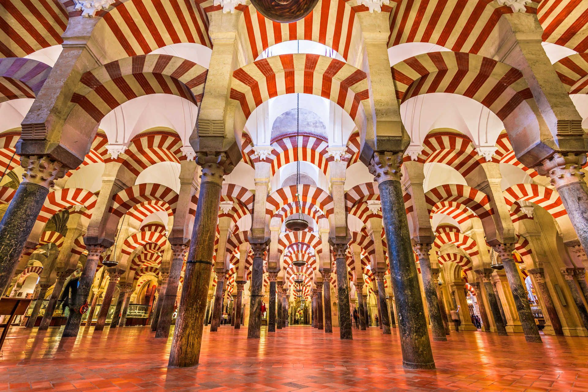
Cordoba
## Description The Mezquita de Córdoba (commonly referred to as the Mosque–Cathedral of Córdoba) is one of Spain’s most striking architectural masterpieces, blending Islamic and Christian elements into a single, atmospheric monument. Its forest of red-and-white double arches, an ingenious structural and aesthetic solution developed in the 8th and 9th centuries, creates a hypnotic interior rhythm that has captivated visitors for centuries. What makes the Mezquita distinctive is not only its scale and decorative richness, but also its layered history: first a Visigothic site, then a grand mosque during Al-Andalus, and later converted into a cathedral after the Reconquista. The result is an unusual palimpsest of art and faith, where horseshoe arches, ornate mihrab mosaics, and later Renaissance chapels coexist in one vast interior. Little-known facts: the current cathedral nave was inserted into the mosque in the 16th century after repeated political and religious negotiations, leaving a striking contrast between the Muslim prayer hall and a centrally placed Christian choir. Another subtle detail is that several columns were recycled from nearby Roman and Visigothic ruins, embedding older materials into this Islamic monument. ## Location The Mezquita is located in Córdoba, Andalusia, southern Spain. It sits in the historic core (the Judería), a compact medieval district adjacent to the Guadalquivir River. The precise address is Plaza del Campo Santo de los Mártires, 1, Córdoba, Andalusia, Spain. Getting there: Córdoba is on Spain’s high-speed rail network (AVE) with frequent trains from Madrid (about 1 hour 45 minutes) and Seville (about 45 minutes). From Córdoba’s main train station (Estación Córdoba Central), the Mezquita is a 15–20 minute walk through the old town; taxis and local buses are also available. If you’re driving, look for parking near Avenida del Alcázar; from there the old town is a short walk. Once inside the historic center, much is best experienced on foot. ## Tips - Buy tickets in advance: The Mezquita can get extremely crowded, especially during high season. Pre-booked tickets with a timed entry avoid long queues. - Visit at quieter times: Early morning just after opening or late afternoon before closing are the best times for photography and to avoid tour groups. - Dress respectfully: As an active cathedral, modest clothing is appreciated. - Allow time for the surrounding quarter: The Judería, Calleja de las Flores, and the Roman bridge are part of the full Córdoba experience—plan at least 2–3 hours to explore the mosque-cathedral and nearby streets. - Use an audio guide or a knowledgeable guide: There’s a lot of layered history; a guide helps unpack architectural changes, symbolic elements, and the timeline of conversions. - Combine with other sites: Pair the Mezquita with the Alcázar of the Christian Monarchs and the Medina Azahara archaeological site for a broader historical view. ## Conclusion The Mezquita de Córdoba is an unforgettable site where architecture tells a story of cultural exchange, conquest, and coexistence. Its forest of arches, rich mosaics, and the surprising placement of the cathedral nave inside a former grand mosque make it a must-visit for lovers of history, architecture, and complex heritage. A mindful visit, planned for quieter hours, will reveal subtleties many miss on a quick stop. ## FAQ Q: Is the Mezquita still used for religious services? A: Yes. While much of the building functions as a major cultural monument and tourist site, the cathedral section hosts Christian religious services. Q: How long should I plan to visit? A: Expect 1.5–3 hours to explore the main areas and enjoy nearby streets. Add more time if visiting exhibitions or local museums. Q: Are photography and flash allowed? A: Photography is usually allowed without flash; however, rules can change for certain ceremonies or exhibitions—follow posted signs. Q: Is the Mezquita accessible for visitors with reduced mobility? A: Parts of the site have limited accessibility due to historic flooring and narrow passages; check official accessibility information and consider contacting the site before arrival. ## Links - [Wikipedia: Mezquita–Cathedral of Córdoba](https://en.wikipedia.org/wiki/Mosque–Cathedral_of_C%C3%B3rdoba) - [Official tourism page for Córdoba (visit cordoba)](https://www.turismodecordoba.org)
GemVoyage Team • World
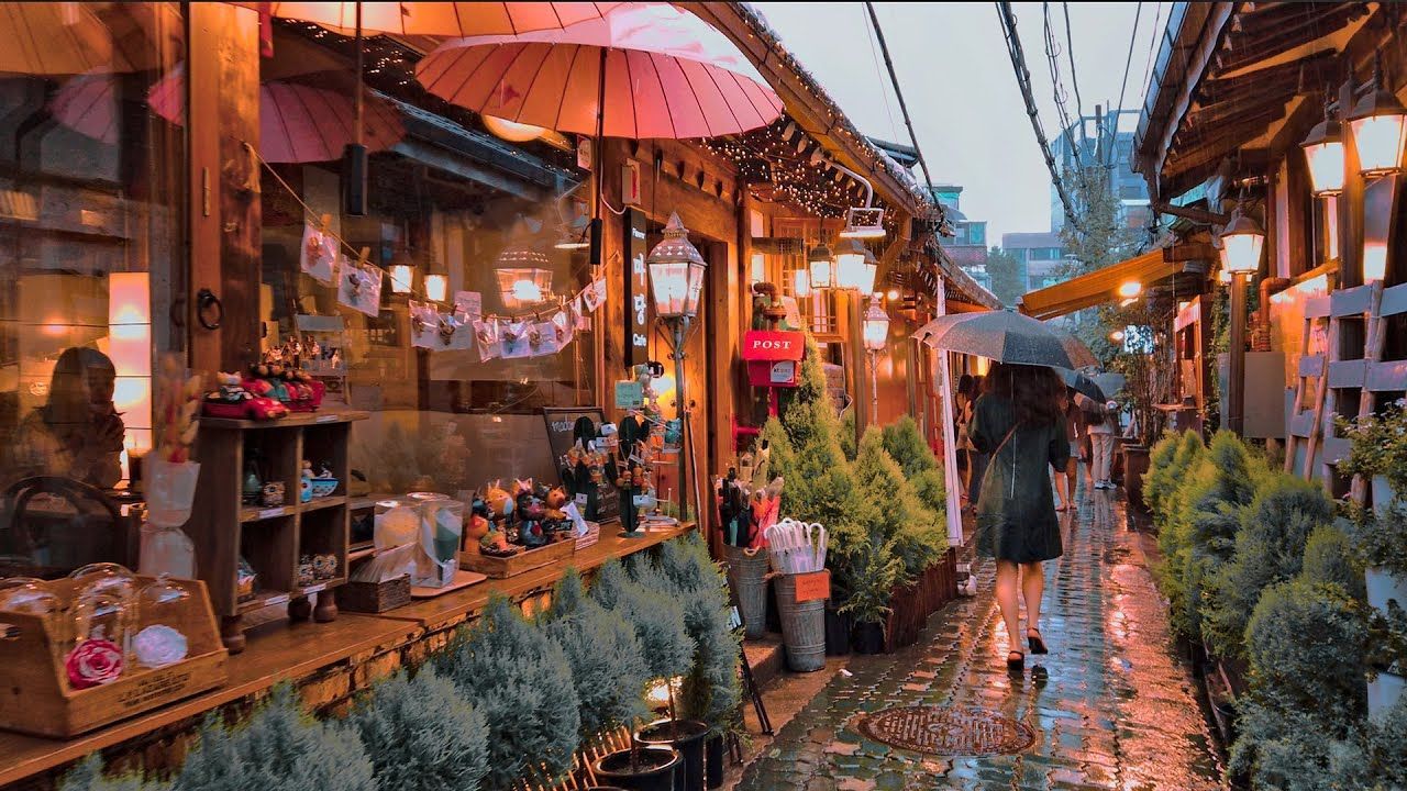
Seoul
## Description Ikseon-dong Hanok Village is a compact, walkable district of restored traditional Korean houses (hanok) that has quietly become one of Seoul’s most charming destinations for visitors who prefer intimate, offbeat experiences. Narrow alleys thread between low-slung wooden eaves and tiled roofs, leading to a concentration of independently run cafes, craft shops, design ateliers, small restaurants, and boutique guesthouses. What makes Ikseon-dong compelling is its layered character: from a distance it reads as preserved tradition, but up close you’ll find contemporary interiors, modern light fixtures, and bold small-business design that sits harmoniously within historic exteriors. Many of the hanok are careful restorations completed in the last decade, which means you get the visual poetry of old Seoul with the conveniences and comforts of modern hospitality. The neighborhood is an excellent example of sensitive urban revitalization—locals and entrepreneurs have repurposed former residential clusters into a dense network of micro-businesses that reward slow exploration. Ikseon-dong’s scale is part of its appeal: where larger hanok districts can feel staged or touristy, here the alleys are intimate and discoveries are often serendipitous—an influential ceramicist around the corner, a tiny cocktail bar behind a lacquered doorway, a handcrafted stationery shop tucked beneath an old roof. ## Location Ikseon-dong sits in Jongno-gu in central Seoul, a short walk from Jongno 3-ga station and easily combined with visits to nearby cultural anchors like Changdeokgung Palace and Insadong. For many travelers, Ikseon-dong makes a great half-day detour from the palace circuit: it’s compact enough to be explored on foot and centrally located so you can move quickly between historic sites, galleries, and dining options. ## Tips - Explore deliberately: walk slowly, follow side alleys, and allow time to peek into courtyards and small doorways—some of the best cafes and shops are not visible from main lanes. - Try specialty menus: many cafes in Ikseon-dong focus on single-origin coffee, artisanal teas, or themed tasting menus—ask staff for recommendations and seasonal specials. - Respect residents: while the area is visitor-friendly, many hanok still function as private homes or small businesses; be mindful when photographing doorways and courtyards. - Visit at different times: morning light highlights wooden details and offers quieter streets, whereas evenings bring lantern-lit alleys and a more atmospheric café-and-bar scene. - Accessibility note: alleys can be narrow with occasional steps; check individual venues for wheelchair access before visiting. ## Conclusion Ikseon-dong is a delightful micro-neighborhood that reimagines traditional architecture for modern urban culture. It’s ideal for café-hopping, thoughtful shopping, photography, and discovering small-scale craftsmanship. The district rewards curiosity: the more time you give it, the more layered the experience becomes—historic textures, contemporary comforts, and a localized creative energy that feels authentically Seoul. ## FAQ Q: Is Ikseon-dong very touristy? A: It has grown in popularity but remains smaller and more intimate than other hanok districts like Bukchon; mornings are generally quieter. Q: Are there places to stay in Ikseon-dong? A: Yes, a handful of boutique hanok guesthouses and small guest accommodations offer overnight stays—book early for weekends. Q: What’s the best time of day to visit? A: Early morning for quiet exploration and late afternoon into evening for lantern-lit ambiance and café culture. Q: Is it wheelchair accessible? A: The historic alleys have uneven paving and steps in places—accessibility varies by venue; call ahead for specific locations. Q: Can I take photos freely? A: Public areas are fine for photography, but be respectful in private courtyards and ask permission before photographing people or inside shops. ## Links - [Korean Travel Guide](https://english.visitkorea.or.kr)
GemVoyage Team • World

Comments