Discover extraordinary places shared by our community of travelers
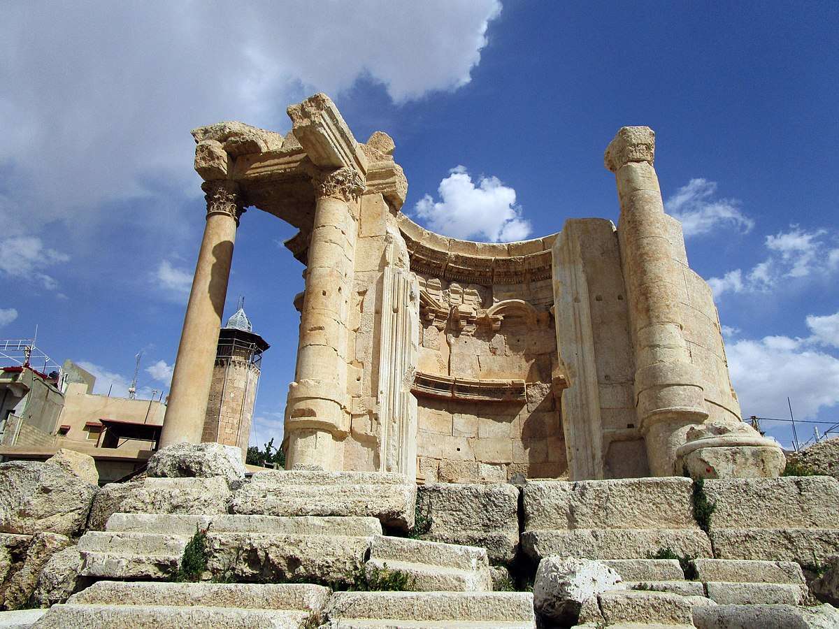
Baalbek
## Description The Temple of Venus in Baalbek, Lebanon, is a captivating remnant of Roman architecture and religious history, tucked within one of the most impressive archaeological complexes in the Middle East. Built in the 3rd century AD, this temple stands out for its **unusual circular design**, a departure from the more common rectangular Roman temples. It was dedicated to Venus, the Roman goddess of love and beauty, and its elegant structure reflects the sensuality and grace associated with her worship. Unlike the colossal temples of Jupiter and Bacchus nearby, the Temple of Venus is more intimate in scale but no less remarkable. It sits atop a horseshoe-shaped platform and features a circular shrine with a square entrance. The outer façade is adorned with five niches, each decorated with carvings of doves and shells—symbols traditionally linked to Venus. These details, along with the temple’s baroque-style curves and arches, showcase a fusion of Roman and Hellenistic architectural techniques. A little-known fact: the temple was later converted into a Christian church dedicated to Saint Barbara, a martyr whose legend is still revered in Lebanon. According to tradition, she was killed by her pagan father for converting to Christianity, and the temple’s continued use as a sacred site reflects the layered religious history of Baalbek. Today, a small mosque stands nearby, underscoring the site’s enduring spiritual significance across centuries and faiths. ## Location The Temple of Venus is located in **Lebanon**, within the **Baalbek-Hermel Governorate**, in the ancient city of **Baalbek**. This city lies in the **northern Bekaa Valley**, a region known for its fertile lands and rich historical tapestry. ### How to Get There: - **By Car**: From Beirut, Baalbek is about a 2-hour drive northeast. The route via Zahle offers scenic views of the Bekaa Valley. - **By Bus**: Public minibuses run from Beirut’s Cola Station to Baalbek, though schedules can be irregular. - **By Tour**: Many guided tours from Beirut include Baalbek’s temple complex, often paired with visits to Anjar or Ksara Winery. Once in Baalbek, the Temple of Venus is just a short walk from the main entrance to the Roman ruins, southeast of the Temple of Jupiter. ## Tips for Visitors To make the most of your visit to the Temple of Venus, consider these tips: - **Visit Early or Late**: The site can get hot and crowded midday. Morning or late afternoon offers better lighting and fewer tourists. - **Wear Comfortable Shoes**: The terrain is uneven, with ancient stones and gravel paths. - **Hire a Guide**: A local guide can provide rich historical context and point out hidden details you might miss. - **Respect the Site**: This is a sacred and historical location. Avoid climbing on ruins or touching carvings. - **Bring Water and Sunscreen**: The Bekaa Valley can be dry and sunny, especially in summer. - **Explore the Whole Complex**: Don’t miss the nearby temples of Jupiter and Bacchus, which are among the largest Roman temples ever built. ## Conclusion The Temple of Venus in Baalbek is a graceful and historically rich monument that offers a unique glimpse into Roman spirituality, architectural innovation, and Lebanon’s layered religious heritage. Its elegant design and enduring presence make it a must-visit for history lovers and curious travelers alike. ## FAQ **1. When was the Temple of Venus built?** It was constructed in the 3rd century AD during the Roman Empire. **2. What makes the Temple of Venus unique?** Its circular design, horseshoe-shaped platform, and symbolic carvings distinguish it from typical Roman temples. **3. Is the temple part of a larger complex?** Yes, it’s part of the Baalbek temple complex, which includes the massive temples of Jupiter and Bacchus. **4. Can I visit the temple year-round?** Yes, the site is open daily and accessible throughout the year. **5. Is there an entrance fee?** Yes, entry to the Baalbek ruins requires a ticket, which includes access to the Temple of Venus. **6. Is the site family-friendly?** Absolutely. The complex is suitable for children and offers a fascinating educational experience. ## Links - [Baalbek Temple of Venus – Livius Ancient History](https://www.livius.org/articles/place/heliopolis-baalbek/baalbek-photos/baalbek-temple-of-the-venus/)
GemVoyage Team • World
Berlin
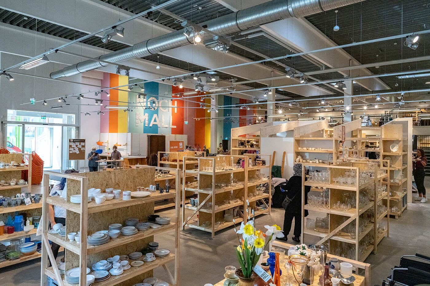
## Description **NochMall** is one of Berlin’s most unconventional, forward-thinking shopping destinations and stands as **Europe’s largest reuse department store**. Unlike traditional second-hand shops or flea markets, NochMall operates as a **professionally curated reuse center**, where discarded items are rescued, restored if necessary, and offered for resale in a structured, retail-style environment. Its mission goes far beyond commerce: NochMall exists to promote **sustainability, waste reduction, circular economy principles, and conscious consumption**. The name “NochMall” comes from the German phrase meaning “once again,” perfectly reflecting its role in giving objects a second life. The store is operated by **BSR (Berliner Stadtreinigungsbetriebe)**, Berlin’s public waste management company. This alone makes it unique—most cities focus on disposal and recycling, while Berlin has invested in a large-scale, public **reuse infrastructure** that turns waste prevention into an accessible urban service. Inside the massive warehouse-style space, visitors find a wide and constantly changing range of items: **furniture, home décor, bicycles, electronics, books, kitchenware, tools, children’s toys, musical instruments, sports equipment, and clothing**. Everything comes from Berlin households, salvage collections, or BSR recycling centers. Items that are still usable are inspected, cleaned, priced, and placed on display instead of being destroyed. What sets NochMall apart from ordinary thrift stores is its **department-store-style layout**. Products are organized into clear categories, with professional shelving, signage, and lighting. The atmosphere is bright, modern, and surprisingly calm. Prices are deliberately kept **affordable but realistic**, reflecting both value and sustainability goals rather than aggressive profit margins. NochMall is also an **educational and cultural space**. It regularly hosts **repair workshops, upcycling courses, sustainability lectures, school programs, and community events**. The attached café reinforces the idea that this is not just a store, but a **social meeting point for environmentally conscious urban life**. A little-known fact is that NochMall diverts **thousands of tons of usable goods from Berlin’s waste stream every year**, directly reducing landfill pressure and raw-material consumption. Another lesser-known detail is that some of the furniture sold in the store is **professionally refurbished by local social enterprises**, creating both environmental and social value through job creation and vocational training. For visitors, NochMall offers something truly different: the chance to experience sustainability not as a theory, but as a **practical, well-functioning urban system**—and to take part in it. ## Location **NochMall** is located in the **Reinickendorf district** in the **northwestern part of Berlin**, an area with a strong industrial and logistics character, well suited to large-scale sustainability infrastructure. **City:** Berlin **Region:** Berlin State (Bundesland Berlin) **Country:** Germany **District:** Reinickendorf ### How to Get There: * **By S-Bahn:** Take **S25** to **Alt-Reinickendorf**, then walk about 10–12 minutes. * **By U-Bahn:** Take **U6** to **Scharnweberstraße**, then continue by bus or taxi. * **By bus:** Several local bus lines serve the surrounding industrial area. * **By car:** Easy access via main arterial roads; on-site parking is available. * **By bicycle:** Cycling is possible, though the industrial surroundings favor longer-distance riders. While NochMall is not located in a classic tourist district, it is easily reachable with public transport and well worth the trip for anyone interested in sustainability, design, or alternative shopping experiences. ## Tips * **Visit with spare time:** Nochmal is large and constantly changing; allow at least 90 minutes to explore properly. * **Go without a fixed shopping list:** The best finds are often unplanned discoveries. * **Check electronics carefully:** Everything is tested, but it’s still smart to inspect functionality before purchase. * **Bring a way to transport bulky items:** Larger furniture may require a car, delivery service, or cargo bike. * **Ask staff for new arrivals:** Some sections receive fresh stock several times per week. * **Attend a workshop:** Repair and upcycling events add real educational value to your visit. * **Combine with sustainability tourism:** Pair NochMall with visits to eco-focused districts or urban gardening projects. * **Donations are possible:** If you live in Berlin, you can legally donate usable items through BSR systems. ## Conclusion **NochMall** is far more than a resale store. It is a **large-scale, real-world model of circular economy in action**, proving that reuse can be organized with the same professionalism as mainstream retail. By transforming waste into resources, education into practice, and shopping into a responsible act, NochMall represents one of Berlin’s most meaningful modern innovations. For travelers and residents alike, it offers not just bargains, but a powerful insight into the future of sustainable cities. ## FAQ **1. What is NochMall exactly?** NochMall is **Europe’s largest reuse department store**, operated by Berlin’s public waste management company, focusing on resale instead of disposal. **2. Is NochMall a normal second-hand shop?** No. It is a **professionally structured reuse center**, significantly larger and more organized than typical thrift stores. **3. Are the items donated?** Yes. Items come from **Berlin households, recycling centers, and municipal collection systems**. **4. Are the products tested and safe to use?** Yes. Electronics and technical items are **checked for basic functionality and safety** before being sold. **5. Is NochMall only for Berlin residents?** No. It is **open to everyone**, including tourists. **6. Can I donate items directly at the store?** Donations are usually handled through **official BSR collection systems**, not directly at the sales floor. ## Links * [Official NochMall Website](https://www.nochmall.de)
GemVoyage Team • World
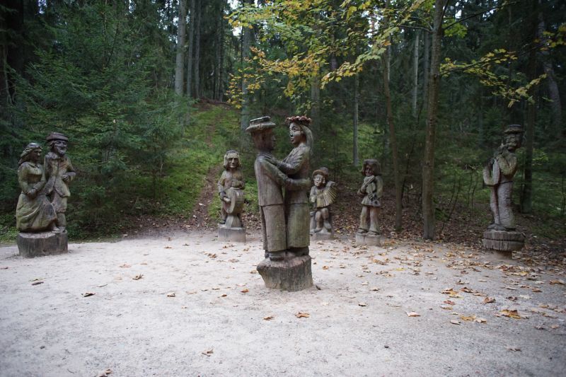
Juodkrantė
## Description The Hill of Witches (Raganų Kalnas) near Juodkrantė is an outdoor open-air gallery where folklore and forest meet. Carved wooden sculptures—dozens of them—depict figures from Lithuanian myths, pagan legends, and fairytales, arranged along a winding forest path that rises toward the Dune Rim. This combination of art and natural setting creates a narrative walk: each sculpture is a tableau within the pine woods, offering an immersive way to learn about Baltic mythology while enjoying the seaside atmosphere of the Curonian Spit. Little-known facts: many sculptures are replaced or restored periodically because of the coastal weather; the site has also hosted temporary contemporary art installations connecting modern voices to age-old tales. Additionally, the hill was intentionally designed to blend with the natural dune and forest so that the art feels like an organic part of the landscape rather than an imposition. The site is both poetic and family-friendly, with hauntingly beautiful carvings that are approachable for children while thought-provoking for adults. Seasonal cultural events sometimes include storytelling evenings and folklore workshops. ## Location Raganų Kalnas is on the Curonian Spit, an elongated sand dune peninsula that separates the Curonian Lagoon from the Baltic Sea, in western Lithuania. The hill lies near the small resort village of Juodkrantė in Neringa municipality, Klaipėda County. How to get there: Neringa is reachable by ferry or car via Klaipėda and then over the Curonian Spit road; public buses connect Klaipėda with Nida and other Spit settlements. From Juodkrantė center, the Hill of Witches is an easy walk along marked paths. ## Tips - Visit early morning or late afternoon to avoid crowds and capture the soft light through the pines. - Wear sturdy shoes—the path can be sandy and uneven. - Bring a guidebook or download a map to understand the individual sculptures and stories. - Check for temporary exhibitions or cultural events—these often enhance the experience. - Combine the visit with a walk along the nearby dunes or a ferry ride on the Curonian Lagoon. ## Conclusion The Hill of Witches is a uniquely Baltic blend of art, folklore, and landscape: a short visit on the Curonian Spit that leaves a lasting impression through its carved narratives and coastal forest atmosphere. ## FAQ Q: Is the Hill of Witches accessible year-round? A: Yes, but winter weather can be harsh; spring through autumn is optimal. Q: Are the sculptures original? A: Many are original but are periodically replaced or restored due to weathering. Q: Is there an entrance fee? A: There may be a modest fee for some event programs, but the site is generally free to visit. Q: Can I bring children? A: Yes—children usually enjoy the sculptural storytelling. ## Links - [Hill of Witches (Wikipedia)](https://en.wikipedia.org/wiki/Hill_of_Witches)
GemVoyage Team • World
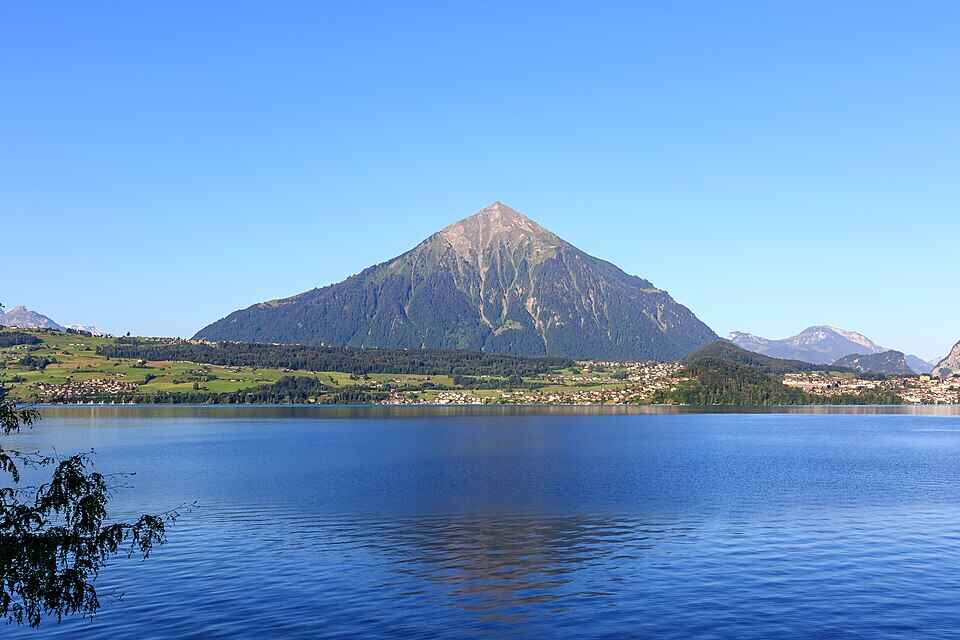
Bernese Oberland
## Description Niesen Mountain, often referred to as the “Swiss Pyramid,” is one of Switzerland’s most visually striking peaks. Its near-perfect triangular shape resembles the iconic Egyptian pyramids, making it a favorite subject for artists like Paul Klee and Ferdinand Hodler. Rising to an elevation of 2,362 meters (7,749 feet), Niesen offers panoramic views over Lake Thun, the Bernese Alps, and the Simmen and Kander valleys. What makes Niesen truly unique isn’t just its shape—it’s the experience of getting to the summit. Visitors can ascend via the **Niesenbahn**, a historic funicular railway that’s been operating since 1910. The ride itself is a scenic journey, taking just 30 minutes to reach the top. But here’s a little-known fact: running alongside the funicular is the **world’s longest stairway**, with a staggering 11,674 steps. While it’s not open to the public for regular use, it hosts an annual stair run event that draws athletes from around the globe. Another charming detail? The mountain’s original name was “Yesen,” derived from the yellow gentian flower, which still blooms on its slopes today. ## Location Niesen is located in **Switzerland**, within the **Canton of Bern**, specifically in the **Bernese Oberland** region. The mountain overlooks **Lake Thun** and lies between the municipalities of **Wimmis** and **Reichenbach im Kandertal**. ### How to Get There: - **By Train**: Take a train to **Mülenen**, a small village that serves as the base station for the Niesenbahn funicular. - **By Car**: Mülenen is accessible via the A6 motorway. Parking is available near the funicular station. - **By Public Transport**: Swiss Travel Pass holders enjoy discounted fares on the funicular, making it an ideal choice for tourists. Once in Mülenen, hop on the funicular for a scenic ride to the summit. ## Tips for Visitors To make the most of your visit to Niesen, consider the following tips: - **Time Your Visit**: The mountain is open from mid-April to mid-November. For the most breathtaking views, aim for a sunrise or sunset trip—overnight stays at the Berghaus Niesen Kulm offer this magical experience. - **Book Ahead**: The funicular and restaurant can get busy during peak season. Booking tickets and meals in advance is highly recommended. - **Dress Appropriately**: Weather can change quickly at high altitudes. Bring layers, even in summer. - **Photography**: Don’t forget your camera—the glass pavilion at the summit offers unobstructed views perfect for landscape shots. - **Dining**: Try the full-moon dinner or breakfast buffet at the summit restaurant for a truly memorable culinary experience. - **Family Friendly**: Story rides and cultural events make Niesen a great destination for kids too. ## Conclusion Niesen Mountain is more than just a scenic peak—it’s a blend of natural beauty, historical charm, and cultural significance. Whether you're drawn by its pyramid shape, the thrill of the funicular ride, or the serenity of alpine views, Niesen offers an unforgettable Swiss experience. ## FAQ **1. What is the elevation of Niesen Mountain?** Niesen stands at 2,362 meters (7,749 feet) above sea level. **2. How do I reach the summit?** You can take the Niesenbahn funicular from Mülenen, which takes about 30 minutes to reach the top. **3. Is the stairway open to the public?** No, the 11,674-step stairway is only accessible during the annual Niesen stair run event. **4. When is the best time to visit Niesen?** Between mid-April and mid-November. Sunrise and sunset visits are especially stunning. **5. Are there accommodations at the summit?** Yes, the Berghaus Niesen Kulm offers cozy rooms and dining options with spectacular views. **6. Is Niesen suitable for children?** Absolutely. There are story rides and cultural activities designed for families. ## Links - [Official Niesen Website](https://www.niesen.ch/en/) - [Switzerland Tourism – Niesen](https://www.myswitzerland.com/en-us/destinations/niesen/)
GemVoyage Team • World
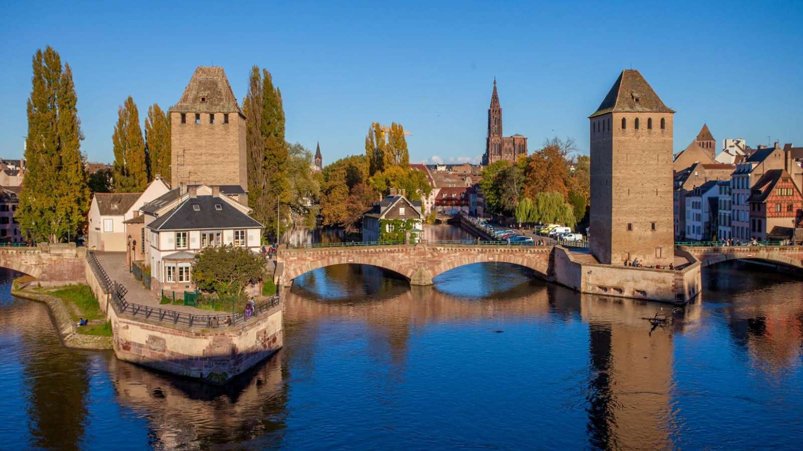
Strasbourg
## Description The Strasbourg Covered Bridges, known locally as *Ponts Couverts*, are a striking ensemble of medieval bridges and towers that span the River Ill in the heart of Strasbourg’s historic *Petite France* district. Built in the 13th century as part of the city’s fortifications, these bridges were originally topped with wooden roofs to protect defenders during sieges—hence the name “covered bridges.” Though the roofs were removed in the late 18th century, the name has endured, preserving a link to their defensive past. The site consists of three stone bridges and four imposing towers, each once part of the city’s ramparts. These towers served as watchposts and prisons until the early 19th century, and their robust Gothic architecture still evokes the strategic importance of Strasbourg during medieval times. Today, the bridges offer stunning views of the surrounding canals, half-timbered houses, and the nearby *Barrage Vauban*, a 17th-century dam and panoramic terrace. A little-known fact: the Ponts Couverts were superseded by the Barrage Vauban in 1690 as the city’s main defensive structure, but they continued to serve as pedestrian and transport bridges. Another intriguing detail is that the towers still bear visible embrasures—narrow slits used for archers and gunmen to defend the city. ## Location The Covered Bridges are located in **France**, within the **Grand Est Region**, in the city of **Strasbourg**. They sit at the western edge of the *Petite France* quarter, one of the most picturesque and historically rich areas of the city. ### How to Get There: - **By Tram**: Take tram lines B or F and get off at *Alt Winmärik*. From there, it’s a short walk to the bridges. - **By Foot**: If you’re exploring central Strasbourg, the bridges are easily accessible from the Strasbourg Cathedral and Place Kléber. - **By Bike**: Strasbourg is one of Europe’s most bike-friendly cities. Rent a bike and follow the riverside paths to reach the bridges. - **By Car**: Parking is limited in the old town. It’s best to park in one of the designated lots outside the center and walk in. Their central location makes them a perfect starting point for exploring Strasbourg’s historic core. ## Tips for Visitors To make the most of your visit to the Strasbourg Covered Bridges, consider these tips: - **Visit at Sunset**: The golden light reflecting off the water and historic buildings creates a magical atmosphere. - **Climb the Barrage Vauban**: Just upstream, this dam offers a panoramic terrace with the best views of the bridges and towers. - **Explore Petite France**: Wander through the cobbled streets and canals nearby for a full immersion in Strasbourg’s medieval charm. - **Photography**: Bring a wide-angle lens to capture the full scope of the bridges and towers. - **Learn the History**: Consider joining a guided walking tour to understand the strategic importance of the bridges and their evolution. - **Avoid Peak Hours**: Early mornings or late evenings are quieter and more peaceful. ## Conclusion The Strasbourg Covered Bridges are a captivating blend of medieval engineering, historical intrigue, and scenic beauty. Whether you're a history enthusiast, a photographer, or a casual traveler, this site offers a timeless glimpse into Strasbourg’s fortified past and its enduring charm. ## FAQ **1. Are the Strasbourg Covered Bridges still covered?** No, the wooden roofs were removed in 1784, but the name “Covered Bridges” remains. **2. Can you walk across the bridges?** Yes, the bridges are open to pedestrians and offer beautiful views of the surrounding canals and towers. **3. Is there an entrance fee?** No, visiting the bridges is free. The nearby Barrage Vauban also has free access to its panoramic terrace. **4. What is the best time to visit?** Sunset or early morning offers the best lighting and fewer crowds. **5. Are the towers accessible to the public?** The towers themselves are not open for interior visits, but you can admire them from the outside. **6. Is the site wheelchair accessible?** Yes, the bridges and surrounding paths are accessible, though some cobbled areas may be uneven. ## Links - [Visit Strasbourg – Covered Bridges Information](https://www.visitstrasbourg.fr/en/fiche-sit/F223007617_the-covered-bridges-strasbourg/) - [Strassburg.eu – Covered Bridges Guide](https://www.strassburg.eu/en/covered-bridges-strasbourg)
GemVoyage Team • World
Samogitia
## Description Žemaitija National Park, anchored by the scenic Plateliai Lake, is a standout example of Lithuania’s western Samogitian landscape: rolling forests, glacial lakes, and a rich cultural heritage. What makes this park unique is the combination of water-centered recreation and preserved rural traditions. Plateliai Lake is the largest lake in the park and offers a classic Lithuanian landscape of glassy water, wooded shores, and scattered islets. Visitors will find peaceful village life, historic manors, and small museums that present local folklore and ethnography. A little-known fact: the park preserves several sites tied to Samogitian cultural identity, including local craft traditions and seasonal rites which are still observed in nearby villages. Another lesser-known element is the network of underwater archaeological finds in Plateliai Lake—remnants of older settlements and boating artifacts discovered by divers, now sometimes referenced by local guides. The park’s mix of outdoor activity and intangible cultural heritage makes it a destination for nature lovers, photographers, and anyone interested in rural Lithuanian traditions. In addition to swimming and boating on the lake, there are marked hiking and cycling trails, observation points for birdwatching, and a few modest but charming guesthouses that connect visitors with local cuisine and hospitality. ## Location Žemaitija National Park is in northwestern Lithuania, in the historical region of Samogitia (Žemaitija), near the town of Plateliai in Plungė district, Telšiai County. The park sits roughly 100–150 km northwest of Kaunas and about the same southwest of Vilnius, making it accessible as a multi-day stop on a trip across Lithuania. How to get there: by car the most flexible option—use the A1/A11 roads from Kaunas or the route via Šiauliai depending on start point. From Vilnius, trains and buses to Telšiai or Plungė followed by a short local bus or taxi ride to Plateliai are practical. During summer tourist season local tour operators run trips that include lake boat trips and guided hikes. ## Tips - Best time: late spring through early autumn for boating and hiking; autumn colors are vivid and ideal for photography. - Bring insect repellent for forest trails and a lightweight waterproof jacket—weather can change quickly. - Rent a kayak or small boat in Plateliai to explore secluded bays; sunrise on the lake is particularly tranquil. - Respect local customs and private land boundaries—many trails cross pastoral land. - If interested in cultural programming, check Plateliai museum opening times in advance; some craft demonstrations are seasonal. - Book accommodation in advance during weekends and public holidays. ## Conclusion Žemaitija National Park and Plateliai Lake offer a balanced, authentic Lithuanian experience: tranquil lakeside scenery, woodlands, and a living connection to Samogitian cultural life. It suits visitors who enjoy gentle outdoor activities combined with opportunities to learn about regional traditions. ## FAQ Q: Is Plateliai Lake suitable for swimming? A: Yes—there are safe swimming spots and beaches, but always follow local signage and conditions. Q: Can I rent boats or kayaks on the lake? A: Yes, local operators in Plateliai rent boats and kayaks in season. Q: Are there guided tours of the park? A: Local guides and visitor centers can arrange guided hikes, birdwatching, and cultural visits—book ahead in high season. Q: Is the park family-friendly? A: Yes, with easy trails, picnic sites, and gentle water activities suitable for families. Q: Are there marked cycling routes? A: Yes, several mapped cycling routes traverse scenic roads and trails in the park. ## Links - [Žemaitija National Park (Wikipedia)](https://en.wikipedia.org/wiki/%C5%BDemaitija_National_Park)
GemVoyage Team • World
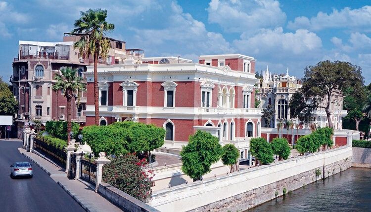
Cairo
## Description **Aisha Fahmy Palace** is one of Cairo’s most elegant examples of early 20th-century aristocratic architecture and a rare survivor of the city’s Belle Époque period. Built in **1907**, the palace reflects a time when Cairo’s elite embraced European artistic influences while maintaining a distinct Egyptian identity. Today, it stands not as a frozen relic, but as a carefully restored cultural venue that bridges past luxury with contemporary artistic expression. The palace was commissioned by Ali Fahmy Pasha and later inherited by his daughter, Aisha Fahmy, whose name it still carries. Designed by Italian architect Antonio Lasciac, the building combines **Italian Renaissance influences with Art Nouveau and neoclassical details**. Marble staircases, ornate ironwork, stained glass windows, and elaborately decorated ceilings reveal the level of craftsmanship invested in elite residential architecture at the time. What makes Aisha Fahmy Palace particularly compelling is its **interior artistry**. The walls and ceilings feature painted panels inspired by classical European mythology, floral motifs, and allegorical scenes, many of which were executed by European artists working in Cairo. A lesser-known fact is that the palace once hosted private salons and cultural gatherings attended by prominent figures from Egypt’s political and artistic circles. Another overlooked detail is that, despite periods of neglect during the late 20th century, much of the original decorative work survived and was meticulously restored rather than replaced. Today, the palace functions as a **temporary exhibition space** under the Egyptian Ministry of Culture. Contemporary art exhibitions are staged within the historic rooms, creating a deliberate contrast between modern creative expression and early 1900s aristocratic interiors. This dialogue between eras is central to the palace’s renewed relevance. ## Location **Country:** Egypt **Governorate:** Cairo **District:** Zamalek Aisha Fahmy Palace is located in **Zamalek**, one of Cairo’s most refined and leafy neighborhoods, situated on Gezira Island in the Nile. ### How to Get There * **By taxi or ride-hailing:** * The most practical option, especially from central Cairo or downtown. * **By metro:** * Take Line 2 to **Opera Station**, then walk or take a short taxi ride. * **On foot:** * Easily reachable when exploring Zamalek’s cultural venues and riverfront. * **By car:** * Limited street parking is available in the surrounding area. ## Tips * **Check exhibition schedules in advance:** The palace hosts rotating exhibitions rather than permanent displays. * **Allow time to explore interiors:** The architectural details are as important as the artworks. * **Visit during daylight hours:** Natural light enhances the painted ceilings and stained glass. * **Photography rules vary:** Some exhibitions may restrict interior photography. * **Combine with nearby sites:** Zamalek offers galleries, cafés, and cultural centers within walking distance. * **Expect calm rather than crowds:** The palace remains relatively uncrowded compared to major museums. ## Conclusion Aisha Fahmy Palace is a refined cultural landmark that captures a sophisticated chapter of Cairo’s modern history. Its restored interiors, aristocratic architecture, and evolving role as an art space make it a rewarding destination for visitors seeking depth, elegance, and context beyond the city’s ancient monuments. ## FAQ **1. Is Aisha Fahmy Palace a museum?** It functions primarily as a temporary exhibition venue rather than a traditional museum. **2. How old is the palace?** It was completed in 1907. **3. How long should I plan for a visit?** Approximately **45 minutes to 1.5 hours**, depending on exhibitions. **4. Is there an entrance fee?** Yes, a modest fee is usually charged and may vary by exhibition. **5. Is the palace suitable for children?** Yes, particularly for older children interested in art or architecture. **6. Is the palace accessible?** Accessibility is limited in some areas due to the historic structure. ## Links * [Experience Egypt tourism portal](https://www.experienceegypt.eg)
GemVoyage Team • World
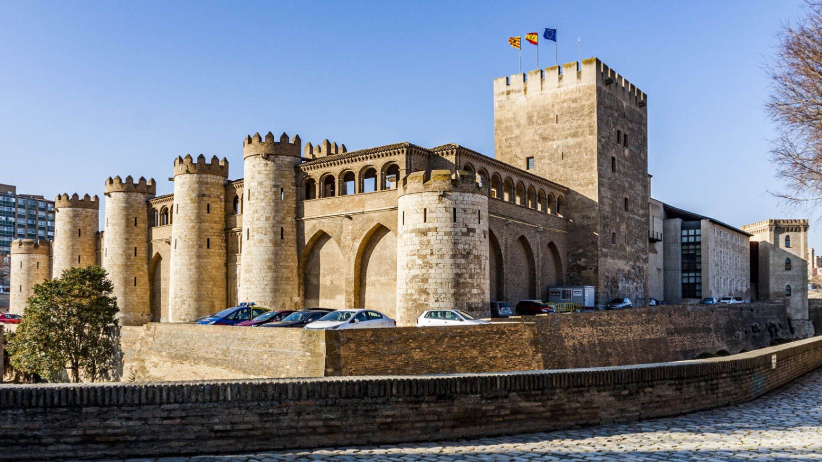
Zaragoza
## Description The **Palacio de la Aljafería** is one of Spain’s most remarkable monuments, a living testimony to the country’s diverse cultural and architectural history. Built in the second half of the 11th century by the Muslim rulers of Zaragoza, the palace originally served as a fortified royal residence during the taifa kingdom period. Its delicate arches, intricate stucco work, and lush courtyards reflect the splendor of Islamic art at its peak in the Iberian Peninsula. What makes Aljafería unique is the way its history is layered within its walls. After the Christian conquest of Zaragoza in 1118, the palace was transformed into the residence of the Catholic monarchs, Ferdinand and Isabella, who added Renaissance elements while preserving much of the Islamic structure. Later, it served as a military barracks, and today it houses the regional parliament of Aragón. Few buildings in Spain embody such a continuous blend of Islamic, Christian, and modern political life. A little-known fact is that the palace inspired key architectural motifs in Spain’s most famous Moorish monument, the **Alhambra in Granada**. Another fascinating detail is that the palace appears in literature: it is the setting for *Las Cortes de la Muerte*, a play by Lope de Vega, reflecting its enduring cultural significance. ## Location The Aljafería Palace is located in **Zaragoza**, the capital of the **Aragón** region in northeastern **Spain**. The palace lies just west of Zaragoza’s city center, on Calle de los Diputados, about 20 minutes on foot from the Plaza del Pilar, where the Basilica of Our Lady of the Pillar stands. Visitors arriving by train to Zaragoza-Delicias station can reach the palace in around 10 minutes by bus or taxi. From Madrid or Barcelona, Zaragoza is easily accessible by high-speed AVE train in just over 1.5 hours, making the Aljafería an ideal stop for travelers exploring northern Spain. Walking or public transport is the best way to reach the palace once in the city. ## Tips * **Book in advance:** Entry is limited, and guided tours often sell out quickly, especially in peak tourist seasons. * **Take a guided tour:** Guides explain the symbolism of the Islamic decorations and the historical transitions that shaped the palace. * **Check opening hours:** The palace is closed on certain public holidays and has reduced hours in winter. * **Combine with other sites:** Pair your visit with the Basilica del Pilar and La Seo Cathedral for a full picture of Zaragoza’s religious and cultural heritage. * **Photography tip:** Morning light is best for photographing the courtyards and intricate arches. Flash photography inside is not permitted. * **Allow enough time:** Set aside at least 1.5–2 hours to fully enjoy the architecture, exhibitions, and gardens. ## Conclusion The **Aljafería Palace** is a masterpiece of Islamic architecture in Spain, later enriched with Christian and Renaissance elements. Its rich history, architectural beauty, and continued political role make it one of Zaragoza’s most important landmarks. For travelers seeking to understand Spain’s layered cultural identity, the Aljafería is an unmissable destination. ## FAQ **1. What is the Aljafería Palace best known for?** It is best known for its Islamic architecture from the taifa period, its later Christian additions, and its role as the seat of the Aragonese parliament. **2. How much time do I need to visit?** A thorough visit takes about 1.5 to 2 hours, especially if you join a guided tour. **3. Is the palace family-friendly?** Yes, the palace is suitable for families. Children often enjoy exploring its courtyards and fortress-like exterior. **4. Are guided tours available in English?** Yes, guided tours in English and other languages are available but should be booked in advance. **5. Is the palace included in UNESCO World Heritage?** The Aljafería itself is not individually listed, but it is part of the broader UNESCO designation of **Mudejar Architecture of Aragón**, recognized for its cultural significance. **6. Can I buy tickets online?** Yes, tickets can be purchased online through official Zaragoza or Aragón tourism websites. ## Links * [Official Tourism of Aragón – Aljafería Palace](https://www.turismodearagon.com) * [Zaragoza Tourism – Palacio de la Aljafería](https://www.zaragoza.es/turismo)
GemVoyage Team • World
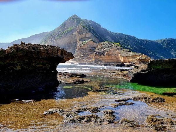
Sedgefield
## Description **Gericke’s Point** is one of the hidden gems of South Africa’s Garden Route. Famous for its striking sandstone cliff that resembles the profile of a lion’s head, this natural landmark offers both geological beauty and incredible biodiversity. At low tide, the area transforms into a natural aquarium, revealing tidal pools brimming with colorful marine life such as starfish, sea anemones, and small fish. The rock formation itself is over 150 million years old, part of the ancient Table Mountain sandstone system. Its unusual shape and size make it one of the most photogenic spots along the coast. Beyond its geology, Gericke’s Point is also a birdwatcher’s paradise, with seabirds often seen diving for fish and dolphins occasionally passing offshore. A little-known fact is that the tidal pools here are considered some of the most diverse along the Garden Route, making it a favorite spot for marine biologists and nature enthusiasts. Another fascinating detail is that the rock face has long been a landmark for sailors navigating the coast between Sedgefield and Wilderness. ## Location Gericke’s Point is located near **Sedgefield**, a small town along the **Garden Route** in the **Western Cape Province** of **South Africa**. It lies about 25 kilometers from Knysna and around 40 kilometers from George. To reach the point, visitors typically start at Swartvlei Beach near Sedgefield. From there, a scenic beach walk of about 2–3 kilometers leads to the rock formation. The best time to go is at low tide, when the tidal pools are accessible and the walk is safe. Travelers driving the Garden Route can easily stop at Sedgefield, with parking available near the beach entrance. ## Tips * **Check the tide tables:** Low tide is the only safe and rewarding time to visit. High tide can make the walk dangerous. * **Wear sturdy shoes:** Although the walk is along the beach, exploring the tidal pools requires footwear with good grip. * **Bring a camera:** The lion-shaped rock formation and vibrant tidal pools make for excellent photography opportunities. * **Pack water and sun protection:** There are no facilities along the beach walk, so carry essentials with you. * **Respect marine life:** Avoid disturbing or removing creatures from the tidal pools—this is a fragile ecosystem. * **Stay for sunset:** The area is particularly stunning in the golden light of late afternoon, with the rock formation silhouetted against the ocean. ## Conclusion Gericke’s Point is more than just a rock formation—it is a window into South Africa’s geological past and a living showcase of coastal biodiversity. With its tidal pools, dramatic cliffs, and sweeping ocean views, it offers a perfect mix of adventure and tranquility along the Garden Route. For travelers seeking a memorable nature experience off the beaten path, Gericke’s Point is not to be missed. ## FAQ **1. How long is the walk to Gericke’s Point?** The walk from Swartvlei Beach to Gericke’s Point takes about 30–40 minutes each way, depending on pace and tide conditions. **2. Is it safe to swim near Gericke’s Point?** Swimming is possible in some tidal pools, but the open ocean can be rough. Always exercise caution and avoid strong currents. **3. Can children visit the point?** Yes, children often enjoy exploring the tidal pools, but they should be supervised closely due to slippery rocks and the incoming tide. **4. Is there an entrance fee?** No, Gericke’s Point is free to access, though parking at Swartvlei Beach may sometimes require a small fee. **5. What wildlife might I see?** In addition to tidal pool creatures, visitors may spot dolphins offshore, oystercatchers, and other seabirds. In whale season (June–November), southern right whales are sometimes visible. **6. When is the best time to visit?** The best time is at low tide and preferably in the morning or late afternoon when temperatures are milder and light conditions are ideal. ## Links * [Visit Garden Route – Sedgefield](https://www.visitgardenrouteandkleinkaroo.com) * [South African Tourism – Garden Route](https://www.southafrica.net)
GemVoyage Team • World