GemVoyage Team • World
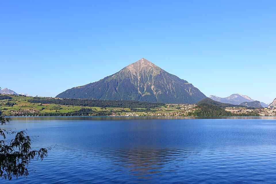
Niesen Mountain, often referred to as the “Swiss Pyramid,” is one of Switzerland’s most visually striking peaks. Its near-perfect triangular shape resembles the iconic Egyptian pyramids, making it a favorite subject for artists like Paul Klee and Ferdinand Hodler. Rising to an elevation of 2,362 meters (7,749 feet), Niesen offers panoramic views over Lake Thun, the Bernese Alps, and the Simmen and Kander valleys.
What makes Niesen truly unique isn’t just its shape—it’s the experience of getting to the summit. Visitors can ascend via the Niesenbahn, a historic funicular railway that’s been operating since 1910. The ride itself is a scenic journey, taking just 30 minutes to reach the top. But here’s a little-known fact: running alongside the funicular is the world’s longest stairway, with a staggering 11,674 steps. While it’s not open to the public for regular use, it hosts an annual stair run event that draws athletes from around the globe.
Another charming detail? The mountain’s original name was “Yesen,” derived from the yellow gentian flower, which still blooms on its slopes today.
Niesen is located in Switzerland, within the Canton of Bern, specifically in the Bernese Oberland region. The mountain overlooks Lake Thun and lies between the municipalities of Wimmis and Reichenbach im Kandertal.
Once in Mülenen, hop on the funicular for a scenic ride to the summit.
To make the most of your visit to Niesen, consider the following tips:
Niesen Mountain is more than just a scenic peak—it’s a blend of natural beauty, historical charm, and cultural significance. Whether you're drawn by its pyramid shape, the thrill of the funicular ride, or the serenity of alpine views, Niesen offers an unforgettable Swiss experience.
1. What is the elevation of Niesen Mountain?
Niesen stands at 2,362 meters (7,749 feet) above sea level.
2. How do I reach the summit?
You can take the Niesenbahn funicular from Mülenen, which takes about 30 minutes to reach the top.
3. Is the stairway open to the public?
No, the 11,674-step stairway is only accessible during the annual Niesen stair run event.
4. When is the best time to visit Niesen?
Between mid-April and mid-November. Sunrise and sunset visits are especially stunning.
5. Are there accommodations at the summit?
Yes, the Berghaus Niesen Kulm offers cozy rooms and dining options with spectacular views.
6. Is Niesen suitable for children?
Absolutely. There are story rides and cultural activities designed for families.
Discover more hidden gems you might love.
Berlin
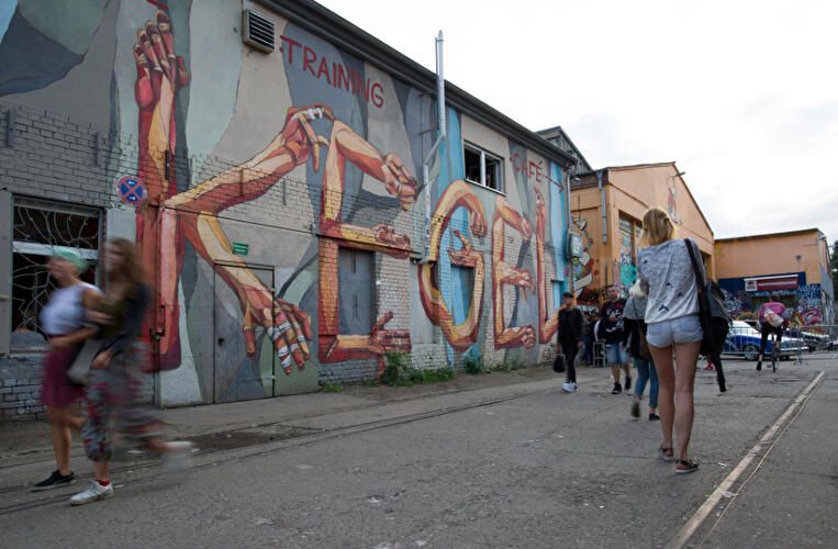
## Description RAW-Gelände is one of Berlin’s most vivid examples of how the city has repurposed industrial space into a living cultural district. Located in Friedrichshain, the complex is known for its raw, creative atmosphere, street art, nightlife, event spaces, and independent venues. It does not feel polished in the conventional tourist sense, and that is exactly why people seek it out. The attraction is not a single building or museum hall; it is an urban environment shaped by layers of reuse, subculture, and creative experimentation. Historically, the area served railway and industrial functions, and that past still shapes the look and feel of the site. The result is a place of walls, courtyards, metal structures, graffiti, and open space where culture often feels more improvised than formal. One little-known aspect of RAW-Gelände is that it continues to function as a flexible venue ecosystem rather than a fixed monument. That means the experience can change depending on the day of the week, the season, and what events are running at the time. This fluid character is part of its appeal. Visitors often come for different reasons. Some want nightlife and live music, others come for photography, skating, street art, flea-market browsing, or simply to experience a side of Berlin that feels less curated than the central museum districts. The area reflects a very Berlin idea: the city’s strongest attractions are not always polished icons, but places where people still make, modify, and repurpose space in real time. RAW-Gelände captures that spirit extremely well. What makes it particularly interesting for travelers is the contrast between its industrial shell and its social energy. During the day, some sections feel like an open-air cultural playground. At night, certain venues transform the area into a magnet for music and late-night crowds. Because of that, RAW-Gelände is less about a single checklist moment and more about atmosphere. It is the kind of place where the details matter: the walls, the posters, the music drifting from a doorway, and the sense that the district is still being written by the people using it. ## Location RAW-Gelände is in Berlin, Germany, in the Friedrichshain district near the Warschauer Straße area. That puts it in one of the city’s liveliest neighborhoods, with easy access to public transportation, bars, clubs, and other urban attractions. The easiest way to get there is by U-Bahn, S-Bahn, tram, or taxi to the Warschauer Straße area, then continue on foot. Because the site is embedded in a busy neighborhood, walking the final stretch is usually the best way to understand where you are going and to notice the surrounding street life. If you are already exploring East Berlin, RAW-Gelände fits naturally into a larger route that includes the East Side Gallery, riverfront walking paths, and nightlife around Friedrichshain and Kreuzberg. Visitors should remember that the area is not a single enclosed attraction with one gate and one route. It is a district-like complex, so a little flexibility helps. Some parts may be busier or more active than others depending on the time of day. ## Tips Check ahead for events, especially if you want live music, markets, or club nights, because the site’s appeal changes a lot with programming. Wear practical shoes. The ground can be uneven in places, and the atmosphere is more industrial than manicured. That roughness is part of the visual character. If you are sensitive to noise or crowds, visit earlier in the day. If you want the energetic side of the area, go later and be prepared for a more intense urban environment. Take time to look beyond the obvious venues. The graffiti, passageways, posters, and improvised corners are often as interesting as the headline bars or clubs. RAW-Gelände rewards curiosity and is best approached as a walkable culture zone rather than a conventional sightseeing stop. ## Conclusion RAW-Gelände is a distinctly Berlin attraction shaped by industrial history, street culture, and constant reinvention. It is ideal for travelers who want a gritty, creative, and flexible urban experience rather than a traditional monument. ## FAQ **What is RAW-Gelände?** It is a former railway and industrial site in Berlin that now hosts cultural spaces, nightlife, art, and events. **Is it open all day?** Different parts operate on different schedules, so it is best to check individual venues and event listings. **Is it family-friendly?** Some daytime areas can be, but the overall atmosphere varies and may be more suitable for older visitors depending on the time and event. **What is it best for?** Street art, alternative nightlife, urban photography, and experiencing Berlin’s creative edge. **How much time should I plan?** At least one to two hours for a casual visit, more if you are attending an event or planning to eat and explore nearby areas. ## Links - [Official Website](https://raw-gelaende.de/) - [Berlin tourism information](https://www.visitberlin.de/en)
GemVoyage Team • World
Lille
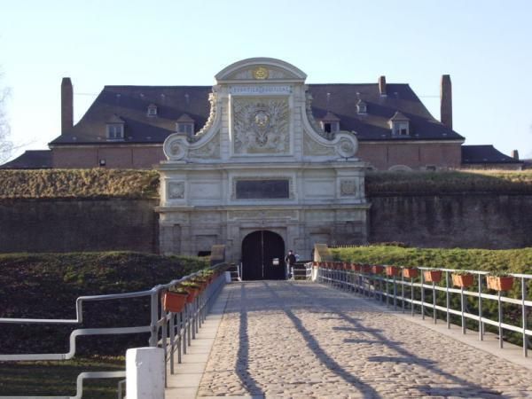
## Description The Citadel of Lille is one of the most impressive military structures in France and a major reason the city is often mentioned in discussions of European fortress design. Built in the 17th century under the direction of Vauban, the citadel is a star-shaped defensive complex that demonstrates both engineering precision and political ambition. It was intended to protect Lille after the city came under French control, and today it stands as a reminder of how military architecture could also shape a city's identity and landscape. What makes the citadel special is that it is not only technically significant but also visually elegant. Its geometric form, wide moats, robust bastions, and open green surroundings make it feel like a fortress designed by someone who understood both defense and urban order. Even if you are not deeply interested in military history, the citadel is compelling because of how it connects architecture, public space, and the natural environment. It is both a monument and a park-like setting, which gives it a very different feeling from densely built old-town landmarks. One little-known fact is that the Citadel of Lille is sometimes referred to as the "queen of citadels" because of its importance in Vauban's defensive system. Another detail many visitors miss is how well the structure fits into the modern city. Although originally conceived for warfare, the citadel now helps define a recreational and cultural zone where walking, cycling, family outings, and visits to nearby attractions all take place. That transformation from military stronghold to civic landmark is part of what makes the site interesting today. The citadel also helps visitors understand Lille's broader history. The city sat near contested borders for centuries, so fortifications were more than symbolic; they were necessary tools of survival and control. Standing at the citadel, you can sense the strategic value of the location and see how a military engineer like Vauban thought about terrain, sightlines, and access. For architecture lovers, history enthusiasts, and casual walkers alike, it is one of Lille's most rewarding destinations. ## Location The Citadel of Lille is in Lille, in the Hauts-de-France region of France, west of the historic center near the Deûle River and surrounding parkland. Its location makes it easy to combine with a broader exploration of Lille's old quarters, especially if you are already spending time around the city center. Unlike a fortress in a remote military zone, this citadel sits comfortably within the urban fabric while still feeling spacious. Getting there is simple by foot, bicycle, or local transport. If you are staying in central Lille, a walk to the citadel is pleasant and reveals how the city's layout changes as you move from dense streets to more open green space. Buses and taxis can also bring you close, but many visitors prefer to use the approach as part of a longer stroll. Because the citadel is surrounded by parks and walking routes, it works especially well as part of a relaxed day outdoors. You can combine it with the nearby zoo, river paths, or other west-side attractions if you want to make the most of the area. ## Tips Allow time for the surroundings as well as the fortress itself. The citadel's setting in parkland is one of its greatest strengths, and the experience improves when you treat it as part of a broader walk rather than a quick photo stop. If you are interested in military history, read a little about Vauban before visiting. His work shaped many French fortifications, and understanding his methods makes the citadel much more meaningful. Visit in good weather if you want to enjoy the outdoor environment fully. The site is enjoyable year-round, but clear conditions make the geometry and scale easier to appreciate. Bring comfortable shoes or use a bicycle if you plan to cover more of the surrounding area. The citadel fits naturally into an active day in Lille and is especially pleasant for travelers who enjoy a mix of history and open-air walking. ## Conclusion The Citadel of Lille is a landmark of French military architecture and a beautiful place to understand the strategic history of the city while enjoying one of its most open and pleasant landscapes. ## FAQ ### Who built the Citadel of Lille? It was designed by Vauban, the famous French military engineer, in the 17th century. ### Why is the citadel important? It is important because it is one of the best examples of Vauban's fortification work and a key part of Lille's historical defense. ### Can you visit the citadel today? Yes. The area is accessible and widely used for walking and recreation, though access may vary in specific sections. ### Is it close to Lille's city center? Yes. It is located west of the center and is easy to reach on foot or by local transport. ## Links - [Lille tourism](https://www.lilletourism.com/) - [Wikipedia article](https://en.wikipedia.org/wiki/Citadel_of_Lille)
GemVoyage Team • World
Druskininkai
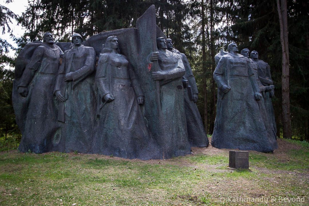
## Description Grūtas Park, often labeled the Soviet Sculpture Park, is a distinctive open-air museum near Druskininkai that preserves monumental artifacts from Lithuania’s Soviet period. Established by collectors and curators who sought to gather statues and relics removed from public squares after Lithuania regained independence, the park assembles these pieces within a designed landscape that encourages critical reflection rather than uncritical nostalgia. The park’s collection includes busts, full-figure monuments, bas-reliefs, and civic emblems that once dominated urban spaces under Soviet rule. What distinguishes Grūtas Park is its curatorial framing: statues are not simply re-installed as aesthetic objects but are placed within an interpretive environment that raises questions about ideology, power, and public memory. Complementing the sculptures are reconstructed Soviet kiosks, everyday artifacts, period signage, and a small indoor museum that provides historical context and archival material. The layout intentionally references the scale and dramatic sightlines of Soviet monumentalism, creating a spatial dialogue between past and present. Visitors often find Grūtas Park both educational and emotionally resonant. Plaques and guided tours unpack the histories behind the monuments, the artists who made them, and the social circumstances that led to their removal and relocation. The park fosters discussion about how societies remember oppressive histories, the ethics of preserving controversial monuments, and creative approaches to public history. ## Location Grūtas Park is located just outside the spa town of Druskininkai in southern Lithuania’s Alytus County, within easy driving distance of Vilnius and Kaunas. The park sits near major regional roads and is well signposted. Travel options include driving by car (the most flexible), regional buses that connect Druskininkai to surrounding towns, and organized day trips from Vilnius or Kaunas. Many visitors combine Grūtas Park with the spa facilities and cultural attractions of Druskininkai for a varied day trip. ## Tips - **Allow sufficient time:** Allocate 1.5–3 hours to walk the outdoor sculpture trails, visit the small museum, and absorb the interpretive materials. - **Use audio guides or join a guided tour:** Contextual information deepens understanding far beyond a walk-by view of statues—learn about the artists, the historical narratives, and the curatorial choices. - **Prepare for emotional responses:** The park’s material can be confronting. Read curator notes and plaques to frame the objects within a critical history of occupation and memory. - **Combine with Druskininkai activities:** Pair the visit with spa treatments, local museums, or nature walks to vary the day’s tone. - **Respect interpretive rules:** Photography is usually allowed for personal use, but check signage for restricted areas or displays. ## Conclusion Grūtas Park offers a unique encounter with Lithuania’s Soviet past: a landscaped gallery of monumental relics curated to foster reflection rather than nostalgia. Whether you are a history buff, art enthusiast, or traveler seeking thoughtful cultural experiences, the park provides a powerful case study in how societies can engage with difficult heritage. ## FAQ - **Q: Is Grūtas Park suitable for families with children?** A: The park is accessible to families, but the themes and imagery can be disturbing to very young children. Parents should prepare to explain historical context and may prefer guided tours that provide age-appropriate framing. - **Q: Are the sculptures authentic originals?** A: Many of the monuments on display were relocated from public squares and municipal collections across Lithuania; in several cases these are original works by mid-20th-century artists. - **Q: Can I take photographs at Grūtas Park?** A: Photography for personal use is generally allowed across the outdoor exhibits; check for any restricted areas or special installations where signage limits photography. - **Q: How much time should I plan for a visit?** A: Plan 1.5–3 hours to experience both the outdoor sculpture trail and the indoor exhibits, and longer if you want to read detailed materials or join a guided program. - **Q: Is there an admission fee?** A: Yes, the park charges an entry fee that helps support maintenance and interpretive programming—confirm current prices on the park’s official site. - **Q: Does the park host temporary exhibitions or events?** A: Grūtas Park occasionally runs temporary exhibitions, film screenings, and guided talks—check the calendar if you want to coincide with special programming. ## Links -- [Grūtas Park (Wikipedia)](https://en.wikipedia.org/wiki/Gr%C5%ABtas_Park)
GemVoyage Team • World
Oslo
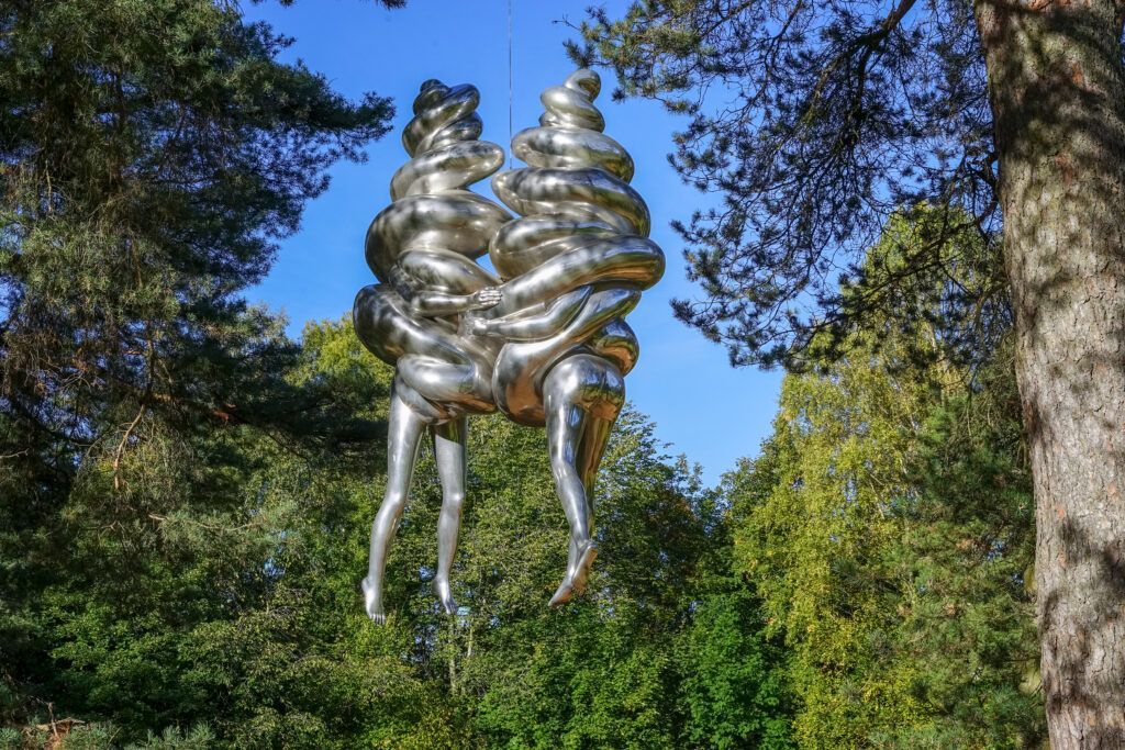
## Description Ekebergparken Sculpture Park is one of Oslo’s most rewarding places to combine contemporary art with open-air exploration. Set on a wooded hill overlooking the city and the Oslofjord, the park mixes sculpture, landscape design, and long walking paths in a setting that feels less like a formal museum and more like an expanded outdoor experience. Visitors come for the art, but many stay for the sweeping views, the quiet forest atmosphere, and the sense that each path can reveal something unexpected. The park’s appeal lies in its variety. One moment you are looking at a monumental sculpture in an open clearing, and the next you are walking through trees where smaller works appear almost discreetly within the landscape. That balance between art and nature gives the park a strong identity. It is also one of the few places in Oslo where you can experience large-scale contemporary sculpture without the pressure of indoor galleries or ticket-driven time limits. The overall effect is relaxed, but it is also carefully curated. One lesser-known aspect of Ekebergparken is that the site has long carried cultural associations beyond its current role as a sculpture park. The hill has been important in Oslo’s history and imagination for centuries, and the park’s placement takes advantage of both the geological terrain and the city views. Another interesting fact is that the park is not only about major names in sculpture; it often rewards visitors who slow down and pay attention to how each work interacts with light, weather, and seasonal changes. A piece that seems subtle in summer can feel dramatically different in winter or at dusk. ## Location Ekebergparken is located in the Ekeberg area of Oslo, Norway, on a hill east of the city center. Its elevated position makes it easy to identify on a map, and the park is accessible from central Oslo without much difficulty. The simplest way to get there is by tram or bus followed by a short uphill walk, though many visitors use taxis or ride-hailing services to save energy for the walking inside the park. If you enjoy city walks, you can also reach the area on foot from central Oslo, but be prepared for a climb. Because the park is spread out, comfortable shoes matter more than almost anything else. ## Tips Wear walking shoes and dress for changing weather, since the park is exposed and conditions can shift quickly. Allow more time than you think you need. The park is best enjoyed slowly, with room for detours and view stops. Bring a camera, but do not rush the experience. Some of the best moments happen when you simply pause at a viewpoint or sit near a sculpture. Visit near sunset if you want the city views at their most dramatic, but note that the park can feel cooler and windier later in the day. Check the park’s current sculpture map or seasonal information before going, since installations and access details can change. ## Conclusion Ekebergparken is one of Oslo’s strongest outdoor cultural experiences, combining sculpture, landscape, and city views in a single memorable walk. ## FAQ ### Is Ekebergparken free to visit? The park itself is generally open as an outdoor public experience, though specific events or facilities may have separate conditions. ### How long should I spend there? Plan at least two to three hours if you want to enjoy both the sculptures and the viewpoints. ### Is Ekebergparken suitable for families? Yes, especially for families that enjoy walking outdoors and exploring art in a relaxed setting. ### What makes the park different from a regular sculpture garden? Its natural setting, large views over Oslo, and integration of art with forest trails make it feel more immersive than a typical sculpture lawn. ### Can I visit in winter? Yes, but dress warmly and expect snowy or slippery paths depending on the season. ## Links - [Official website](https://ekebergparken.com/) - [Ekebergparken on Wikipedia](https://en.wikipedia.org/wiki/Ekebergparken_Sculpture_Park)
GemVoyage Team • World
Milan
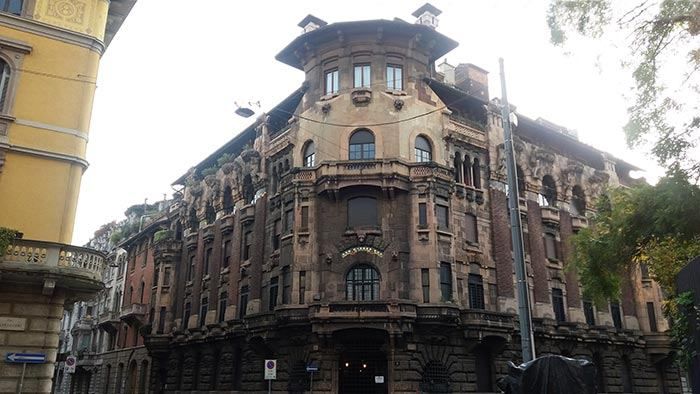
## Description The **Quadrilatero del Silenzio** is one of Milan’s most refined and least touristy architectural districts, a compact residential enclave where **Art Nouveau elegance, early 20th-century symbolism, and aristocratic discretion** converge. Unlike Milan’s grand monumental zones such as the Duomo or Brera, this area is defined by **silence, privacy, and restrained beauty**. It feels less like a destination and more like a secret revealed only to those who actively search for it. The name “Quadrilatero del Silenzio” loosely translates to **“The Quadrilateral of Silence”**, referencing both its **four bordering streets** and the **notable absence of commercial noise and mass tourism**. The district dates primarily to the **early 1900s**, when Milan was undergoing rapid modernization and wealthy families commissioned architects to design villas and palazzi inspired by **Liberty style**, Italy’s version of Art Nouveau. Among the district’s architectural highlights are **Casa Galimberti, Casa Guazzoni, and Palazzo Berri-Meregalli**. These buildings showcase extraordinary decorative detail: floral ironwork, painted ceramic tiles, sculpted balconies, symbolic reliefs, and richly textured façades. Casa Galimberti in particular stands as one of the **most complete Art Nouveau residential structures in Italy**, with its exterior entirely clad in painted ceramic panels depicting allegorical scenes and classical figures. What makes the Quadrilatero del Silenzio especially distinctive is its **spiritual and symbolic undercurrent**. Palazzo Berri-Meregalli, one of the most visually dramatic buildings in the area, incorporates **mystical and occult motifs**, skulls, grotesque faces, and symbolic sculptures linked to esoteric traditions. This hidden symbolic language contrasts sharply with the district’s otherwise calm residential purpose, adding a layer of intrigue beneath the formal elegance. The neighborhood’s emotional atmosphere is **measured and withdrawn**. Tree-lined streets, soft façades, and limited vehicle traffic create a mood unlike the rest of central Milan. There are no major shops, cafés, or attractions competing for attention. Instead, visitors move slowly, examining balconies, doorways, tiled surfaces, and wrought-iron gates just meters from inhabited private homes. This blurs the boundary between **museum-like observation and daily life**. A little-known fact is that Casa Guazzoni’s balcony sculptures were among the **earliest experiments with reinforced concrete sculpture in Milan**, hidden beneath their decorative surfaces. Another lesser-known detail is that much of the district was deliberately zoned as **high-end residential from the outset**, preventing later commercial overdevelopment and preserving its original function for more than a century. Unlike Milan’s fashion districts or historic centers, the Quadrilatero del Silenzio does not sell an experience. It **offers stillness**. It rewards visitors who pay attention to surface texture, ornamental language, and architectural storytelling rather than spectacle. This makes it particularly appealing to architects, photographers, design students, and travelers who prefer subtlety over highlights. The district is not large, and it does not aim to be. Its power lies in **concentration rather than scale**. Within a few blocks, it condenses many of the ideals of Milan’s early modern identity: wealth, experimentation, decorative craftsmanship, and discreet urban living. ## Location The **Quadrilatero del Silenzio** is located in the **eastern part of central Milan**, just outside the city’s main historical core. **City:** Milan **Region:** Lombardy (Lombardia) **Country:** Italy **Main Streets Defining the Area:** * Via Cappuccini * Via Serbelloni * Via Mozart * Via Malpighi ### How to Get There: * **By metro:** * **Line M1 (red line)** to **Porta Venezia Station**, then a 5–8 minute walk. * **By tram:** Several tram lines run through Corso Venezia and Porta Venezia. * **By taxi or ride-hailing:** Direct access with easy drop-off near Via Mozart or Via Cappuccini. * **On foot:** A pleasant walk from the fashion district or the Natural History Museum. The area is ideal to combine with nearby attractions such as **Porta Venezia, Indro Montanelli Public Gardens, and Corso Buenos Aires**. ## Tips * **Visit during daylight:** Architectural details are best visible in natural light. * **Keep voices low:** It is a residential area known for its quiet character. * **Photography is allowed, but be discreet:** Many buildings are private homes. * **No cafés inside the core area:** Plan coffee stops in nearby Porta Venezia. * **Look up as much as you look forward:** Balconies and upper façades hold the most details. * **Best for architecture lovers:** It is not a shopping or entertainment zone. * **Pair it with a museum visit:** The Natural History Museum nearby fits the reflective mood. * **Avoid peak commuter hours:** Traffic is limited but narrow streets amplify sound. ## Conclusion The **Quadrilatero del Silenzio** is one of Milan’s most understated yet culturally dense districts. It reveals a side of the city built not for spectacle but for **craft, symbolism, and quiet luxury**. Through its Art Nouveau façades, discreet streets, and hidden esoteric details, it tells a story of Milan at the dawn of modernity, preserved in a state of rare urban restraint. ## FAQ **1. What is the Quadrilatero del Silenzio?** It is a **small residential architectural district** in Milan known for its Art Nouveau buildings and quiet atmosphere. **2. Why is it called “del Silenzio”?** Because of its **low traffic, lack of commercial noise, and calm residential character**. **3. Is it free to visit?** Yes. It is a **public neighborhood with no entrance fee**. **4. How long does a visit usually take?** Most visitors spend **30 to 60 minutes** walking through the area. **5. Is it good for photography?** Yes, especially for **architectural and detail photography**, though discretion is expected. **6. Is it suitable for families?** Yes, but it is better suited to **slow walking and observation** rather than activities for children. ## Links * [Comune di Milano – Urban Heritage](https://www.comune.milano.it)
GemVoyage Team • World

Socotra
## Description Socotra Island feels like a fragment of another planet — a remote, windswept archipelago in the northwest Indian Ocean whose flora and landscapes defy easy comparison. Part of Yemen’s Socotra Archipelago, the island is famed for its unique biodiversity: roughly one-third of its plant species are endemic, meaning they occur nowhere else on Earth. The emblematic dragon’s blood tree (Dracaena cinnabari) with its umbrella-like silhouette and deep red sap has become a symbol of Socotra’s otherworldly charm. Across the island, landscapes alternate between bizarre limestone plateaus, dramatic sea cliffs, windswept sand flats and pristine white-sand beaches framed by coral reefs. The experience of Socotra is defined by its isolation. Thousands of years of relative climatic stability have allowed life to evolve along separate lines, producing a cast of plants and small reptiles adapted to arid conditions and shallow soils. Visitors remark on the sculptural shapes and strange textures of the vegetation: bulbous succulents, twisted bottle trees, and dense thorny thickets that host endemic birds and invertebrates. This is a place for slow observation — botanizing on rock-strewn plateaus, watching seabirds along cliffs, and learning how local communities have adapted pastoral and fishing traditions to the island’s rhythms. Beyond flora and fauna, Socotra offers an immersive cultural layer. The island’s towns and villages, led by the main hub of Hadibo, display a traditional way of life that blends Bedouin pastoralism with fishing and small-scale commerce. Over the past decade eco-tourism has grown carefully: small guesthouses and locally guided tours emphasize conservation and community benefit. For the adventurous traveler the island’s remote tracks, sea caves and beaches promise solitude and dramatic light, perfect for landscape photography, contemplative walking and quiet wildlife encounters. ## Location Socotra is located in the northwest Indian Ocean, administratively part of Yemen, lying closer to the Horn of Africa than to the Arabian mainland. The island’s primary settlement and logistical hub is Hadibo (sometimes spelled Hadibu) on the northern coast. Historically, reaching Socotra has required careful planning: flights are limited and schedules change with political and logistical conditions. When available, small charter flights connect Socotra with mainland Yemen and, occasionally, regional hubs; sea access — via carefully arranged boat charters or local vessels — is an alternative for those with flexible timing. Because access can be intermittent, most independent travelers book through experienced operators who handle permits, inter-island travel, and local liaison. Visitors should check visa requirements and entry permits well in advance, and factor in contingency days for travel delays. Once on the island, Hadibo serves as the staging point for day trips inland to the Dixam Plateau, the Hagghier Mountains, and coastal excursions to remote beaches and snorkeling sites. ## Tips - **Check travel advisories and logistics:** Socotra’s access and safety status can change with regional developments. Before planning, consult official travel advisories, contact tour operators, and verify flight or sea schedules. Leave buffer days in your itinerary for unexpected delays. - **Use licensed local guides and operators:** Knowledgeable local guides are essential for navigating rocky tracks, interpreting plant life, and arranging transport to remote sites. Hiring local guide services supports the economy and ensures respectful interaction with communities. - **Respect fragile ecosystems:** Much of Socotra’s ecology is fragile. Stick to established tracks, avoid trampling vegetation, do not remove plants or geological material, and use minimal-impact camping practices. - **Pack for varied conditions:** Inland plateaus and mountains can be hot and dry during the day and chilly at night; coastal winds can be strong. Bring sun protection, sturdy hiking boots, a light windproof layer, and a reusable water bottle with a reliable purification method. - **Plan photography and drone use carefully:** Drones may be restricted to protect wildlife and privacy. Always ask local guides about regulations and cultural sensitivities before using camera equipment. - **Health and safety:** Medical facilities on Socotra are basic. Carry a well-stocked first-aid kit, any personal medications, and consider travel insurance with emergency evacuation coverage. Be up to date on routine vaccinations and check for recommended travel vaccines. - **Support local communities:** Choose guesthouses and guides that employ local staff, buy produce and crafts locally, and respect local dress and customs in villages. ## Conclusion Socotra is a destination for travelers who seek radical otherness and ecological rarity. Its alien plant forms, remote beaches, and quiet villages offer an experience both humbling and exhilarating — a reminder of how geographic isolation shapes life in remarkable ways. Thoughtful visitors who arrive well-prepared will find a landscape rich with photographic opportunities, quiet hiking routes, and meaningful encounters with local people and culture. Above all, Socotra rewards patience: time spent watching a dragon’s blood tree silhouette against the sky, or exploring a limestone plateau at dusk, lingers long after the trip ends. ## FAQ - **Q: Is Socotra safe to visit?** A: Safety and access can vary with regional and political conditions. Check up-to-date government travel advisories, consult experienced operators who run tours to Socotra, and register your travel plans with your embassy when appropriate. - **Q: How long should I spend on Socotra?** A: A well-paced visit typically runs 6–10 days. This allows time to explore the Dixam Plateau, the Hagghier Mountains, coastal beaches and a few village visits without feeling rushed. - **Q: When is the best time to visit Socotra?** A: The most comfortable travel window is during the cooler months, roughly October through April. Monsoon-related weather and hot summer temperatures can make travel more difficult in other months. - **Q: Can I arrange independent travel or do I need a tour operator?** A: Because flights and permits are limited, most travelers use reputable operators who arrange logistics, guides and permits. Independent travel is possible but requires local contacts and contingency planning. - **Q: What should I bring for wildlife and landscape photography?** A: Bring a mid-range zoom lens, a wide-angle for landscapes, a sturdy tripod for low-light work, spare batteries and memory cards, and neutral-density filters for coastal long exposures. - **Q: Are there accommodations and food options on the island?** A: Hadibo has small guesthouses and basic restaurants; expect simple but hearty local meals. For remote camping or multi-day excursions, operators typically supply food and equipment — confirm details beforehand. ## Links - [Socotra — Wikipedia](https://en.wikipedia.org/wiki/Socotra)
GemVoyage Team • World

Comments