GemVoyage Team • World
State Library Victoria is more than just a library—it’s a cultural icon, architectural marvel, and a vibrant public space in the heart of Melbourne. Established in 1854, it holds the distinction of being Australia’s oldest public library and one of the first free libraries in the world. Today, it’s also one of the busiest, welcoming millions of visitors each year who come not only to read, but to explore exhibitions, attend events, and marvel at its historic interiors.
The library’s crown jewel is the La Trobe Reading Room, a stunning octagonal chamber topped with a majestic domed ceiling. With its white balconies, timber desks, and natural light streaming through the dome, it’s a favorite spot for students, artists, and photographers. Beyond its beauty, the library houses over five million items, including rare manuscripts, maps, photographs, and artworks. Highlights include Ned Kelly’s original armor and the Jerilderie Letter, offering a glimpse into Australia’s bushranger folklore.
A little-known fact: the library was originally envisioned as a combined museum, gallery, and library. Its founder, Sir Redmond Barry, also laid the foundation stone for the University of Melbourne on the same day as the library’s cornerstone. Another quirky detail—one of the library’s permanent exhibitions includes a collection of human hair, part of a broader exploration of Victorian-era curiosities.
State Library Victoria is located in Australia, in the state of Victoria, within the city of Melbourne. The library sits prominently at 328 Swanston Street, right in the Central Business District (CBD), making it easily accessible and surrounded by shops, cafés, and cultural landmarks.
Its central location makes it a perfect starting point for a day of cultural exploration in Melbourne.
To make the most of your visit to State Library Victoria, keep these tips in mind:
State Library Victoria is a dynamic blend of history, learning, and public engagement. Whether you're diving into research, admiring its architecture, or simply relaxing in the reading room, the library offers a rich and inspiring experience in the heart of Melbourne.
1. Is there an entrance fee to visit State Library Victoria?
No, entry is free for all visitors.
2. What are the library’s opening hours?
Typically, Monday to Thursday: 10 AM – 9 PM; Friday to Sunday: 10 AM – 6 PM. Galleries close at 5 PM daily.
3. Can I take photos inside the library?
Yes, photography is allowed in most public areas, but flash and tripods are discouraged.
4. Is the library suitable for children?
Absolutely. There are dedicated children’s areas and family-friendly events throughout the year.
5. Are food and drinks allowed inside?
Food and drinks are not permitted in reading rooms but are allowed in designated areas.
6. Does the library offer research assistance?
Yes, librarians are available to help with research, and there are dedicated tools for family history and academic inquiries.
Discover more hidden gems you might love.
Siena
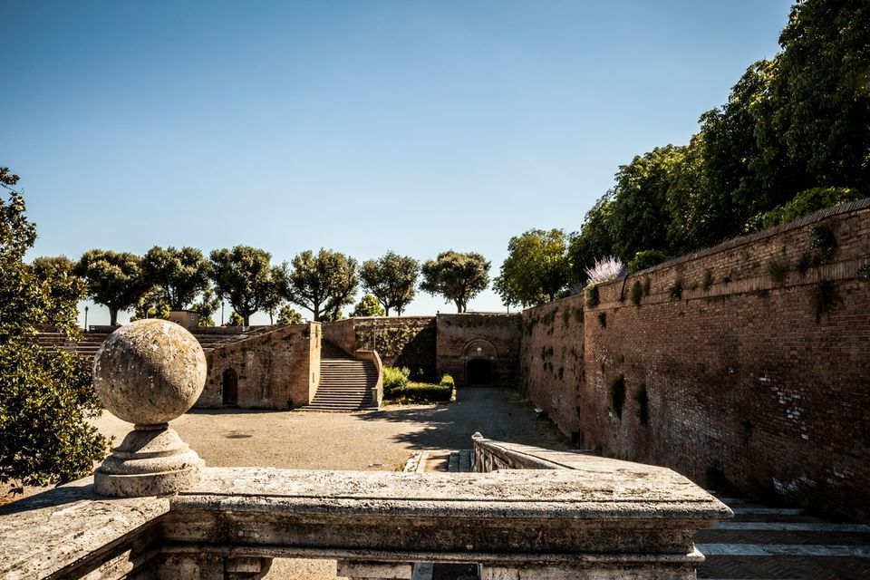
## Description Fortezza Medicea is one of Siena's most imposing landmarks because it represents a different historical layer from the city's medieval churches and squares. Built after Siena's defeat by Florence, the fortress reflects Medici power and the political reshaping of the region during the Renaissance. Unlike a decorative palace or a purely ceremonial monument, it was designed for strategic control and military presence. Today, however, it functions as a public space where history, viewpoints, and local life meet in a surprisingly relaxed way. The fortress is memorable because of its scale and shape. Its bastioned walls form a strong geometric presence above the city, and the elevated position gives visitors sweeping views over Siena and the surrounding Tuscan landscape. That combination of fortification and panorama makes it especially rewarding for travelers who appreciate places where architecture tells a political story. The walls are not just old stone; they are evidence of conquest, rule, and the reshaping of urban space. One little-known fact is that the fortress became less about defense over time and more about civic and cultural use, showing how military architecture can be repurposed for public life. Another detail many visitors miss is how the fortress helps explain the relationship between Siena and Florence. It is not just a monument standing above the city but a reminder of an era when regional power was expressed through earthworks, bastions, and visible control of the landscape. Visitors often appreciate the fortress for its calm atmosphere. While the city center of Siena can be bustling with tourists, the Fortezza Medicea feels more open and spacious. It is a good place to pause, look out across rooftops and hills, and understand how Siena sits within the broader Tuscan setting. If you are interested in military history, urban viewpoints, or Renaissance politics, the fortress is one of the city's most significant stops. ## Location Fortezza Medicea is in Siena, in Tuscany, Italy, just north of the historic center and within walking distance of major city attractions. Because it sits on elevated ground near the old core, it is easy to include in a walking tour of Siena, though the approach may involve some uphill sections depending on your starting point. If you are coming from Piazza del Campo or the cathedral area, the walk to the fortress is straightforward and can be done on foot. Buses and taxis can take you close as well, but walking is usually the best option because it lets you experience the transition from Siena's dense medieval streets to the more open fortified landscape. The most practical recommendation is to visit it while exploring Siena on foot, especially if you want to combine the fortress with other panoramic stops. Because the site is open and spacious, it works well as a late-afternoon or early-evening destination when the light becomes softer. ## Tips Go for the views as much as for the history. The fortress gives some of the best panoramas in Siena, so bring time to linger and not just pass through. If possible, combine the fortress with a walk through the surrounding park-like areas and nearby city streets. That allows you to see how the fortress integrates into Siena's urban edge rather than treating it as a disconnected monument. Read a little about the Medici and the political history of Siena before your visit. Knowing why the fortress was built changes the experience from a simple architectural stop into a clearer story about conquest and control. Visit on a day with good visibility if scenic views matter to you. The fortress is enjoyable in many conditions, but its strongest appeal is the way it frames the city and countryside. ## Conclusion Fortezza Medicea is one of Siena's most powerful historical sites, combining Renaissance military architecture, city views, and a reminder of the region's complex political past. ## FAQ ### Why was Fortezza Medicea built? It was built as a military fortress after Siena came under Medici control, serving as a symbol of political power and strategic dominance. ### Is the fortress open to visitors? Yes, the grounds and surrounding areas are generally accessible, though specific use may vary over time. ### What is the best part of visiting the fortress? The best part is the combination of panoramic views and the chance to understand Siena's political history. ### How long should I spend there? Most visitors spend between 30 minutes and an hour, depending on how much time they want for walking and views. ## Links - [Siena tourism](https://www.visitsiena.it/en/)
GemVoyage Team • World
.jpg)
Scotland
## Description The Fairy Pools on the Isle of Skye in Scotland are a series of crystal-clear, aqua-blue pools and cascading waterfalls that tumble down from the foothills of the Black Cuillin mountains. These natural pools, fed by the Allt Coire a’ Mhadaidh stream, are renowned for their ethereal beauty and have become one of Skye’s most iconic and photographed attractions. Whether you're a hiker, wild swimmer, or simply a lover of dramatic landscapes, the Fairy Pools offer a magical experience that feels straight out of folklore. The walk to the pools is relatively short—about 2.4 kilometers round trip—and follows a well-maintained gravel path that winds through heather-covered moorland. Along the way, visitors encounter a series of waterfalls and pools, each more striking than the last. The water is so clear that you can see the rocky bottoms and reflections of the surrounding hills, making it a favorite spot for photographers and nature enthusiasts. A little-known fact: the area around the Fairy Pools was the site of the last and bloodiest clan battle in Scottish history—the Battle of Coire na Creiche in 1601 between the MacLeods of Dunvegan and the MacDonalds of Sleat. Legend has it that the stream ran red with blood, a stark contrast to its current tranquil appearance. Another quirky detail is that despite their name, there’s no historical association with fairies—the name “Fairy Pools” only began appearing in guidebooks in the 20th century. ## Location The Fairy Pools are located in **Scotland**, on the **Isle of Skye**, near the village of **Carbost** in the **Highland region**. They sit at the base of the Black Cuillin mountains in **Glen Brittle**, on the western side of the island. ### How to Get There - **By Car**: From Portree, the island’s main town, it’s about a 30-minute drive (20.5 miles) via the B8009 and Glenbrittle road. The route includes single-track roads with passing places. - **By Bus**: Public transport is limited. Buses run to Carbost, but you’ll need to arrange a taxi or walk from there. - **By Tour**: Several guided tours from Portree or Inverness include the Fairy Pools as part of a day trip. - **By Foot**: The walk to the pools begins at the Fairy Pools car park, located near Glenbrittle. From the car park, it’s a 20-minute walk to the first waterfall. ## Tips - **Visit Early or Late**: The site gets crowded during peak hours, especially in summer. Early morning or late afternoon offers better light and fewer visitors. - **Wear Waterproof Footwear**: The path can be muddy and uneven, especially after rain. - **Bring Layers**: Weather on Skye is unpredictable. Pack a waterproof jacket and warm clothing. - **Wild Swimming**: Brave souls can swim in the pools, but the water is icy year-round. A wetsuit is recommended. - **Respect Nature**: Follow the Scottish Outdoor Access Code—take your litter with you and stick to marked paths. - **Parking**: There is a charge for parking at the Fairy Pools car park, which helps maintain the site. ## Conclusion The Fairy Pools on the Isle of Skye are a breathtaking blend of natural beauty and Highland mystique. With their vivid waters, dramatic mountain backdrop, and rich history, they offer a memorable experience for anyone exploring Scotland’s rugged landscapes. ## FAQ **1. Is there an entrance fee to visit the Fairy Pools?** No, the pools are free to visit, but there is a charge for parking. **2. How long is the walk to the Fairy Pools?** The round-trip walk is approximately 2.4 kilometers and takes 40 minutes to 1.5 hours depending on pace and stops. **3. Can I swim in the Fairy Pools?** Yes, wild swimming is allowed, but the water is extremely cold. A wetsuit is recommended. **4. Are the Fairy Pools suitable for children?** Yes, but children should be supervised due to uneven terrain and cold water. **5. Is the site wheelchair accessible?** No, the terrain is rugged and includes steep inclines, making it unsuitable for wheelchairs. **6. What is the best time of year to visit?** Spring and autumn offer mild weather and fewer crowds. Summer is busiest, while winter can be icy and less accessible. ## Links - [Fairy Pools Walk – Isle of Skye Guide](https://www.isleofskye.com/skye-guide/top-ten-skye-walks/fairy-pools) - [Fairy Pools – VisitScotland Overview](https://www.visitscotland.com/info/see-do/fairy-pools-p1770011) - [Fairy Pools – Wikipedia Entry](https://en.wikipedia.org/wiki/Fairy_Pools) Description The Fairy Pools on the Isle of Skye in Scotland are a series of crystal-clear, aqua-blue pools and cascading waterfalls that tumble down from the foothills of the Black Cuillin mountains. These natural pools, fed by the Allt Coire a’ Mhadaidh stream, are renowned for their ethereal beauty and have become one of Skye’s most iconic and photographed attractions. Whether you're a hiker, wild swimmer, or simply a lover of dramatic landscapes, the Fairy Pools offer a magical experience that feels straight out of folklore. The walk to the pools is relatively short—about 2.4 kilometers round trip—and follows a well-maintained gravel path that winds through heather-covered moorland. Along the way, visitors encounter a series of waterfalls and pools, each more striking than the last. The water is so clear that you can see the rocky bottoms and reflections of the surrounding hills, making it a favorite spot for photographers and nature enthusiasts. A little-known fact: the area around the Fairy Pools was the site of the last and bloodiest clan battle in Scottish history—the Battle of Coire na Creiche in 1601 between the MacLeods of Dunvegan and the MacDonalds of Sleat. Legend has it that the stream ran red with blood, a stark contrast to its current tranquil appearance. Another quirky detail is that despite their name, there’s no historical association with fairies—the name “Fairy Pools” only began appearing in guidebooks in the 20th century. Location The Fairy Pools are located in Scotland, on the Isle of Skye, near the village of Carbost in the Highland region. They sit at the base of the Black Cuillin mountains in Glen Brittle, on the western side of the island. How to Get There By Car: From Portree, the island’s main town, it’s about a 30-minute drive (20.5 miles) via the B8009 and Glenbrittle road. The route includes single-track roads with passing places. By Bus: Public transport is limited. Buses run to Carbost, but you’ll need to arrange a taxi or walk from there. By Tour: Several guided tours from Portree or Inverness include the Fairy Pools as part of a day trip. By Foot: The walk to the pools begins at the Fairy Pools car park, located near Glenbrittle. From the car park, it’s a 20-minute walk to the first waterfall. Tips Visit Early or Late: The site gets crowded during peak hours, especially in summer. Early morning or late afternoon offers better light and fewer visitors. Wear Waterproof Footwear: The path can be muddy and uneven, especially after rain. Bring Layers: Weather on Skye is unpredictable. Pack a waterproof jacket and warm clothing. Wild Swimming: Brave souls can swim in the pools, but the water is icy year-round. A wetsuit is recommended. Respect Nature: Follow the Scottish Outdoor Access Code—take your litter with you and stick to marked paths. Parking: There is a charge for parking at the Fairy Pools car park, which helps maintain the site. Conclusion The Fairy Pools on the Isle of Skye are a breathtaking blend of natural beauty and Highland mystique. With their vivid waters, dramatic mountain backdrop, and rich history, they offer a memorable experience for anyone exploring Scotland’s rugged landscapes. FAQ 1. Is there an entrance fee to visit the Fairy Pools? No, the pools are free to visit, but there is a charge for parking. 2. How long is the walk to the Fairy Pools? The round-trip walk is approximately 2.4 kilometers and takes 40 minutes to 1.5 hours depending on pace and stops. 3. Can I swim in the Fairy Pools? Yes, wild swimming is allowed, but the water is extremely cold. A wetsuit is recommended. 4. Are the Fairy Pools suitable for children? Yes, but children should be supervised due to uneven terrain and cold water. 5. Is the site wheelchair accessible? No, the terrain is rugged and includes steep inclines, making it unsuitable for wheelchairs. 6. What is the best time of year to visit? Spring and autumn offer mild weather and fewer crowds. Summer is busiest, while winter can be icy and less accessible. Links Fairy Pools Walk – Isle of Skye Guide Fairy Pools – VisitScotland Overview Fairy Pools – Wikipedia Entry 715 words37 lines4484 characters4520 bytes
GemVoyage Team • World
Alkmaar
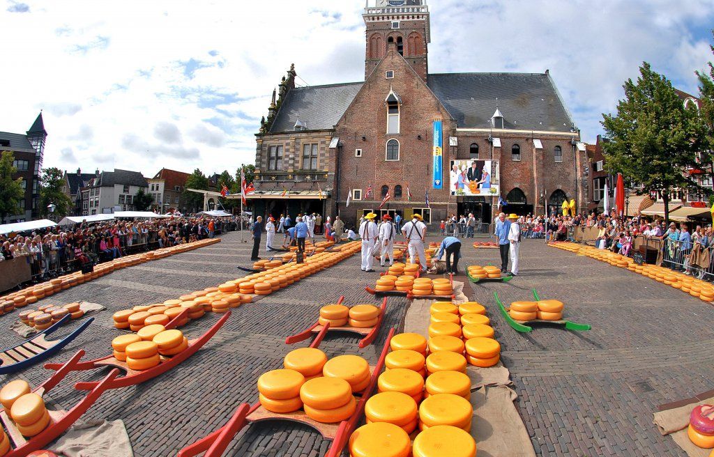
## Description The Alkmaar Cheese Museum is one of the best places to understand why cheese is such an important part of Dutch identity and regional heritage. Located in the historic Waag building, the museum explores the history, production, trade, and cultural significance of cheese in the Netherlands, with special attention to Alkmaar’s long association with the cheese market tradition. It is a compact but engaging museum that helps visitors see cheese not just as food, but as part of a larger economic and social story. One of the museum’s strengths is its accessibility. It presents information in a way that is easy to follow for casual visitors while still giving enough depth to satisfy people interested in local history. The setting matters too: being in a historic weighing house adds a strong sense of place. One lesser-known fact is that Alkmaar’s cheese heritage is linked not only to local farming but also to the broader trading systems that shaped Dutch cities for centuries. Another interesting detail is that the museum helps explain the rituals and practical logistics behind cheese commerce, including how products were measured, moved, and valued in a market town. The museum is also a good reminder that cultural attractions do not have to be large to be effective. Its size makes it easy to fit into a walking day in Alkmaar, and it works especially well when combined with the city’s old streets, canals, and other historic sites. For many visitors, the appeal is partly culinary and partly atmospheric: you learn about cheese, but you also absorb the character of a Dutch market city that built part of its identity around this trade. That makes the museum feel both educational and local. ## Location The Alkmaar Cheese Museum is in the center of Alkmaar, North Holland, the Netherlands, inside the historic Waag building near the city’s old market area. Because it is centrally located, it is easy to reach on foot from most of Alkmaar’s historic core. If you are coming by train, Alkmaar’s station connects well to the city center, and the walk to the museum is straightforward. Visitors arriving from Amsterdam or other nearby cities usually find the trip simple by rail, making it a practical day trip destination. Once in town, the compact center is best explored on foot. ## Tips Combine the museum with a visit to Alkmaar’s historic center for the full experience. If you are interested in the traditional cheese market, check the schedule before your trip so you can align your visit. The museum is a good rainy-day option because it is compact and easy to visit without much planning. Leave room in your itinerary for tasting local cheese or exploring nearby shops. ## Conclusion The Alkmaar Cheese Museum is a small but worthwhile stop that turns the city’s cheese heritage into a clear and enjoyable cultural visit. ## FAQ ### What does the Alkmaar Cheese Museum focus on? It explains the history, trade, and cultural importance of cheese in Alkmaar and the Netherlands. ### Is the museum connected to the cheese market? Yes, it is closely tied to Alkmaar’s famous cheese-trading tradition. ### How much time do I need? A visit usually takes around one hour, depending on how much you read. ### Is it suitable for children? Yes, especially for families that want a short, easy museum visit with a clear theme. ### Can I visit it together with the cheese market? Yes, and that is one of the best ways to experience Alkmaar’s cheese culture. ## Links - [Official website](https://www.kaasmuseum.nl/en/)
GemVoyage Team • World
Bonn
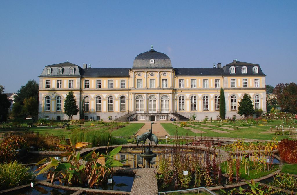
## Description Poppelsdorf Palace Gardens in Bonn offers a quieter, more contemplative travel experience than many people expect from a city stop. The gardens sit beside Poppelsdorf Palace, creating a landscape where formal design, academic history, and botanical interest come together. This is not a flashy amusement-style attraction; it is a place for slow walking, observation, and appreciating the way a historic garden can shape a city experience. For travelers who enjoy architecture and green spaces together, the setting has a calm elegance that is easy to underestimate at first glance. The appeal of the gardens lies in balance. The layout around the palace gives the space a sense of order and historical continuity, while the planting introduces seasonality and change. Depending on when you visit, you may encounter spring blossoms, summer greenery, autumn color, or a quieter winter framework that emphasizes lines and structure. The area feels connected to Bonn’s academic and civic identity, which makes it especially interesting for visitors who want to understand the city through its institutions as well as its monuments. One little-known point is that the surrounding area is tied to the University of Bonn and the wider botanical and scientific traditions of the city. That gives the garden a different character from purely decorative palace grounds. Another detail travelers often appreciate is how peaceful the space can feel even when nearby streets are active. The gardens offer a kind of visual pause, a transition between urban movement and formal green calm. Because the attraction is connected to a palace and university environment, it is also a useful stop for people who enjoy architecture, history, and plant life in one setting. You can admire the building, stroll through the grounds, and then continue into Bonn with a stronger sense of how the city layers its heritage. The result is a destination that feels understated at first but reveals more the longer you stay. ## Location Poppelsdorf Palace Gardens are in Bonn, North Rhine-Westphalia, Germany, within the Poppelsdorf district near the University of Bonn. The location is convenient for travelers already exploring Bonn’s center, because it is reachable from the main urban area without a difficult transfer. Public transport, walking, and cycling are all practical ways to arrive, depending on where you begin. If you are already in central Bonn, walking can be an especially pleasant choice because it lets you approach the gardens gradually and see more of the surrounding district. The area sits comfortably within a wider sightseeing route that might also include the university quarter, museums, and other historic streets. For visitors staying elsewhere in the city, tram or bus connections can make the trip straightforward. ## Tips Visit at a relaxed pace. The gardens are best enjoyed when you are not trying to rush from one photo stop to the next. Sit for a while, study the building and the planting, and let the setting become part of your day rather than a quick pass-through. Use the seasons to your advantage. Spring and early summer are especially rewarding if you enjoy blooms and fresh growth, while autumn can give the grounds a softer, more reflective mood. Even in winter, the geometry of the palace and garden can be appealing if you like architectural landscapes. Pair the visit with other Bonn sights. Because the gardens are part of a larger city context, they work well as a stop between museums, university buildings, or a café break. If you are interested in plant collections or botanic themes, take extra time to notice how the garden’s identity differs from a casual city park. Bring a camera, but also leave room to simply look. The most memorable part of the visit may be the overall calm rather than any single dramatic view. Good shoes, a willingness to walk slowly, and a little curiosity are more useful here than a packed itinerary. ## Conclusion Poppelsdorf Palace Gardens are a graceful and quietly rewarding part of Bonn, combining historic architecture with a restful green setting. They are ideal for travelers who appreciate understated places with depth. ## FAQ ### Are the gardens open to the public? Parts of the grounds are generally accessible as a public green space, but access can vary by area and season. It is sensible to check current information before visiting. ### Do I need to visit the palace itself? No. The gardens can be enjoyed on their own, and many visitors come mainly for the outdoor setting. ### How long should I stay? A short visit may take less than an hour, but a slower walk and nearby exploration can easily fill more time. ### Is this a family-friendly stop? Yes. The space is calm, walkable, and suitable for a relaxed visit with children, provided they are supervised like in any garden environment. ### What is the best time of year to go? Spring and early summer are often the most visually satisfying, but the gardens can be pleasant in any season depending on your interests. ## Links - [Official website](https://www.botgart.uni-bonn.de/en) - [Wikipedia](https://en.wikipedia.org/wiki/Poppelsdorf_Palace)
GemVoyage Team • World
Seoul
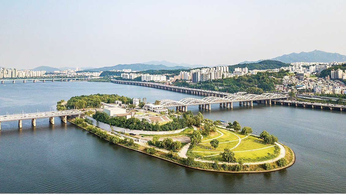
## Description Nodeul Island is a compact cultural complex on the Han River offering performance spaces, green areas, and a music-focused programming lineup. More than just a riverside park, Nodeul is a deliberate cultural experiment: its architecture and programming weave public space, live performance, and small-scale festivals into a compact, walkable site. The island hosts live concerts ranging from acoustic singer-songwriters to electronic sets, pop-up book fairs, artist talks, workshops, and rotating markets. Its landscaped terraces and shaded lawns are deliberately designed to encourage lingering, informal performances, and community gatherings. Nodeul has become known for spotlighting emerging Korean musicians and experimental performers alongside established acts, making it an attractive place for music lovers who want to catch fresh talent in an intimate setting. The island’s mix of architecture, open-air stages, and sheltered rooms means events happen year-round—outdoor stages run during warmer months while smaller indoor spaces host talks and exhibitions in cooler seasons. For photographers and writers looking for evocative urban scenes, Nodeul’s riverside vistas, evening concert lighting, and the soft hum of Seoul traffic across the water make for compelling subjects. The island also supports small food vendors and seasonal stalls that bring a local flavor to the cultural programming. From a practical standpoint, Nodeul is a model for how urban design can activate a riverside edge: pedestrian bridges and plazas, varied seating, and clear sightlines to performance areas keep programming accessible and family-friendly. The island’s public calendar is updated frequently, and local arts organizations often collaborate with the site to pilot new formats—outdoor listening sessions, experimental pop-up shows, and community workshops are common. Whether you’re planning an evening concert or a daytime literature event, Nodeul’s programming rewards repeat visits: familiar artists return, and new creative experiments appear each season. ## Location Nodeul Island sits on the Han River close to the Noryangjin and Yeouido areas of Seoul, reachable by subway and a short walk across a well-maintained pedestrian bridge from the south bank. The nearest major subway stops provide easy access for visitors staying anywhere in central Seoul, and the island’s signage in English and Korean helps international visitors orient themselves quickly. Because the island sits on the river, walking routes from nearby neighborhoods are scenic and often used by locals for jogging and evening strolls. ## Tips - Check the events calendar ahead of time: Nodeul’s draw is its programming, and many of the best concerts and markets are pre-announced online. Booking tickets in advance for popular shows avoids disappointment. - Arrive early for evening concerts to claim good riverside seating; bring a small blanket or foldable chair if you prefer more comfortable seating on the grass. - Visit at sunset for the best photo opportunities: the interplay of river light, concert lights, and Seoul’s skyline creates a memorable atmosphere. - Pack layers—a light jacket is wise for open-air evening events when the river breeze picks up, even in summer. - Explore the island’s perimeter paths before events; quiet spots and viewpoints are often less crowded than main plazas. - Support local vendors: seasonal food stalls and nearby cafés help sustain small operators who participate in Nodeul’s pop-up markets. - If you’re interested in emerging music, follow local promoters and Nodeul’s newsletter for surprise showcases and free programs. ## Conclusion Nodeul Island is a compact cultural destination that combines live music, community programming, and riverside relaxation in Seoul. It succeeds as a place where design, sound, and community converge—ideal for travelers who want to experience contemporary Korean culture beyond mainstream tourist stops. With a packed calendar, accessible layout, and an emphasis on new voices in music and the arts, Nodeul rewards curious visitors and repeat explorers alike. ## FAQ Q: Is there an admission fee? A: Many daytime activities and free concerts are available without charge, while larger evening shows or special events may require purchased tickets—check the event listing. Q: How do I get there by public transport? A: Use the nearest subway stations (check local maps), then follow pedestrian signage to the river bridge that leads to Nodeul; buses and taxis also serve the area. Q: Are events kid-friendly? A: Yes—many daytime workshops and family-oriented performances are suitable for children, though some late-night concerts may be more adult-focused. Q: Can I bring food and drink? A: Outside food and non- alcoholic drinks are generally allowed; licensed vendors operate during larger events—always check event-specific rules. Q: Is the island wheelchair accessible? A: The site offers accessible paths and ramps, but some elevated terraces may have limited access—consult the venue map for specific event locations. ## Links - [Seoul Travel Guide](https://www.visitseoul.net/)
GemVoyage Team • World
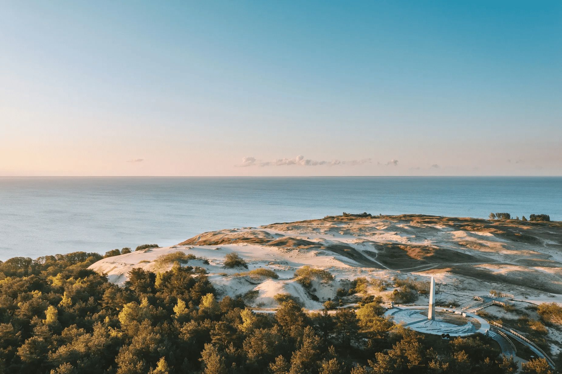
Nida
## Description The Parnidis Dune sundial on the Curonian Spit is an elegant meeting point of coastal geology and human curiosity. Carved into a prominent dune ridge near Nida, the sundial uses a simple stone gnomon and stone markers to register the sun’s arc across the sky, while the dune itself provides sweeping views over the Curonian Lagoon and the Baltic Sea. The combination of sculpted sand, long sightlines, and the shifting play of light makes the site both visually stirring and quietly contemplative. Visitors encounter an open landscape shaped by wind and water: dunes that migrate slowly with prevailing winds, vegetation adapted to sandy, saline conditions, and an expansive horizon where sky and water blend. The sundial is part functional instrument, part landscape sculpture: its hour lines and markers are calibrated to local solar time and offer an accessible way to experience astronomical motion at ground level. Restoration and maintenance are ongoing challenges because the dune is dynamic—sand moves, vegetation changes, and repairs must respect both the scientific accuracy of the instrument and the dune’s natural processes. Local authorities and conservation groups work to stabilize key paths and protect fragile slopes so that people can enjoy the views without accelerating erosion. Cultural events and astronomy programs often use the site as a natural amphitheater, further connecting visitors with the seasonal rhythms of sky and sea. ## Location Parnidis Dune is located in Nida on the Curonian Spit, within Neringa municipality in Klaipėda County on Lithuania’s western coast. The dune crowns a ridge that overlooks the Curonian Lagoon on one side and the Baltic Sea on the other, giving it dramatic vantage points in both directions. How to get there: Nida is accessible by car along the Curonian Spit road from Klaipėda; if approaching from mainland Lithuania, a ferry crossing into the spit may be necessary depending on route. Regular buses also run from Klaipėda to Nida during the tourist season. Once in Nida, the Parnidis Dune is a short, well-signed walk from the town center; follow the marked paths to the main observation points and sundial. ## Tips - Visit at sunrise or sunset for the most dramatic light and to see the sundial’s shadows lengthen. - Stay on marked trails and access ramps—dune vegetation is fragile and paths help prevent runaway erosion. - Bring windproof layers and sun protection; the exposed ridge can be quite breezy even on mild days. - Use binoculars or a telephoto lens to scan the lagoon for birds, fishing boats, and shifting sandbars. - Combine a dune visit with a walk through Nida’s quaint center and nearby cultural sites, such as the Thomas Mann museum. - Check local signage for any temporary closures or restoration work; some sections may be rerouted to protect the landscape. ## Conclusion Parnidis Dune’s sundial offers more than a neat photo opportunity: it is an invitation to feel how landscape, time, and human craft can intersect. The ridge’s panoramic views, paired with the simple mechanics of the sundial, make the place an evocative stop for anyone exploring the Curonian Spit. ## FAQ Q: Is there an admission fee to access the dune? A: There is typically no admission fee to reach Parnidis Dune itself; however, parking or guided services may charge fees. Seasonal event programming may require tickets. Q: When is the best time to photograph the sundial and landscape? A: Sunrise and sunset provide warm, low-angle light that accentuates dune textures and long shadows; golden hour is ideal for landscape photography. Q: Can I climb anywhere on the dune? A: No. To protect dune vegetation and prevent erosion, visitors should use the marked trails and observation points only; climbing fragile slopes is discouraged or prohibited. Q: Are there guided tours or astronomy events at the site? A: Yes. Local guides and cultural groups sometimes offer tours that explain the sundial’s construction and the dune’s ecology; astronomy and cultural events are occasionally scheduled—check Nida’s visitor information. Q: Is the area accessible for visitors with limited mobility? A: Some paths and viewpoints may have improved access, but the dune’s terrain is inherently uneven. Check local visitor resources for the latest information on accessible routes. ## Links - [Parnidis Dune (Wikipedia)](https://en.wikipedia.org/wiki/Parnidis_Dune)
GemVoyage Team • World


Comments