GemVoyage Team • World
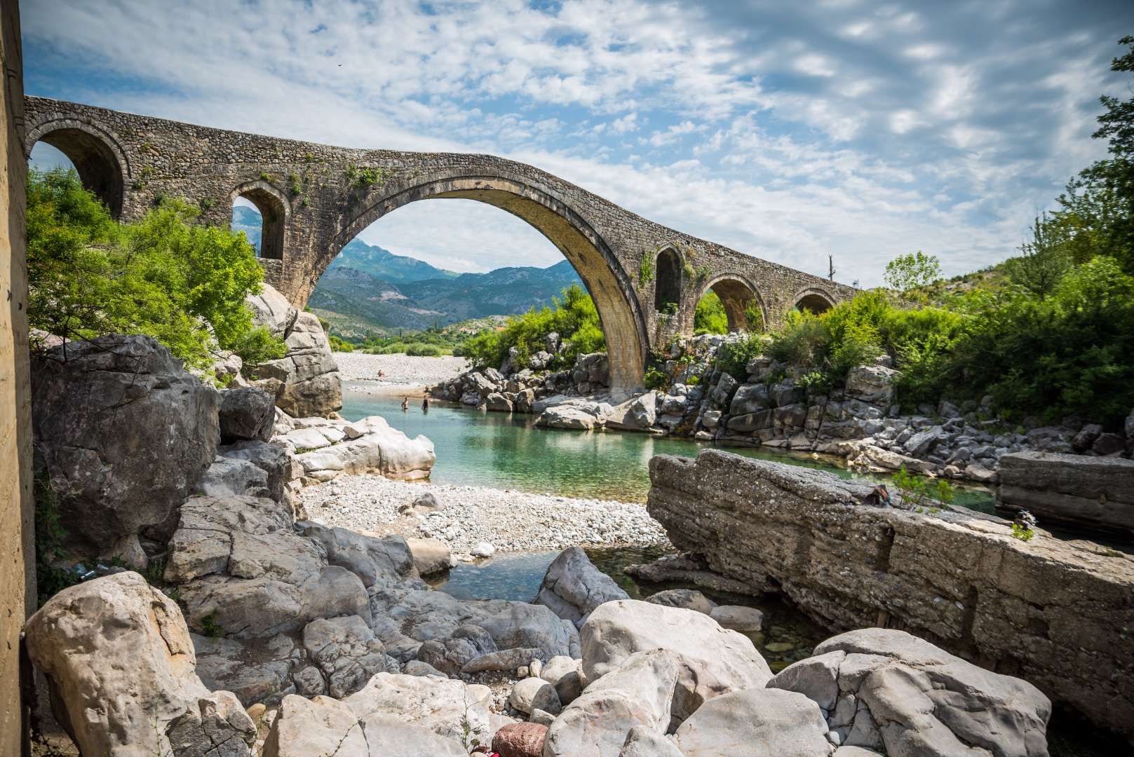
Mesi Bridge (Ura e Mesit), an 18th-century Ottoman-era stone bridge, is one of Albania’s most captivating historical landmarks. Located near the city of Shkodër, this architectural gem spans the Kir River with a graceful series of 13 arches, stretching 108 meters in length. Built around 1770 by Kara Mahmud Bushati, a powerful Ottoman pasha, the bridge was part of a strategic infrastructure project to connect Shkodër with the northern highlands, including the medieval town of Drisht.
What makes Mesi Bridge unique is its asymmetrical design and the craftsmanship of its construction. The bridge was built in two phases: the central arch and one adjacent arch were completed first, followed by the remaining eleven. The structure features round river stones and chiseled stone plates, giving it both strength and aesthetic charm. Despite centuries of wear and occasional flooding, the bridge remains remarkably well-preserved and is considered the largest and best-preserved Ottoman bridge in Albania.
A little-known fact is that the bridge once formed part of a trade route that extended all the way to Pristina, Kosovo. Another intriguing detail is that the English artist Edward Lear sketched the bridge during his travels in Albania in 1848, captivated by its elegance and the surrounding landscape.
Mesi Bridge is located in Albania, in the Shkodër County, near the city of Shkodër. Specifically, it sits in the village of Mes, approximately 5 to 8 kilometers northeast of the city center.
The journey itself is part of the experience, offering views of lush greenery, distant mountains, and traditional Albanian villages.
Mesi Bridge is a stunning example of Ottoman engineering and Albanian heritage. With its elegant arches, historical significance, and picturesque setting, it offers visitors a peaceful and enriching escape just outside Shkodër.
1. Is there an entrance fee to visit Mesi Bridge?
No, the site is free to visit.
2. Can I swim in the Kir River near the bridge?
Yes, swimming is possible, especially in spring and early summer. Water levels may be low in July and August.
3. Is the bridge accessible year-round?
Yes, but heavy rains in winter may make the area muddy or slippery.
4. How long should I plan for the visit?
A visit typically takes 1–2 hours, including time for photos and exploring the surroundings.
5. Is Mesi Bridge suitable for children?
Yes, but supervision is recommended due to uneven surfaces and proximity to the river.
6. Are guided tours available?
Local guides in Shkodër may offer tours that include Mesi Bridge and nearby historical sites.
Discover more hidden gems you might love.
Vigo
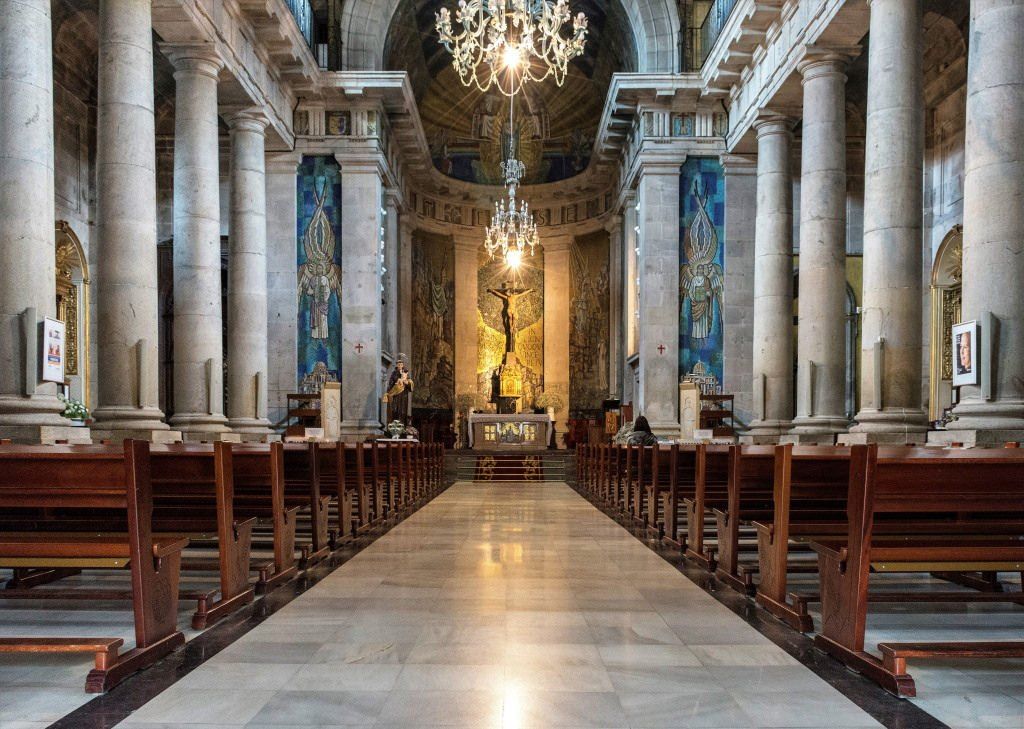
## Description The Concatedral – Basílica de Santa María de Vigo is one of the most important religious and historical monuments in the city of Vigo. Standing prominently in the old town area, this Roman Catholic basilica-concatedral serves as a key symbol of the city’s spiritual heritage and architectural evolution. While Vigo is often associated with its port and modern urban life, this church offers a quieter, more reflective window into its past. What makes the Concatedral – Basílica de Santa María unique is its layered history. The current neoclassical structure, completed in the early 19th century, was built on the remains of earlier Gothic churches destroyed during attacks in the late 16th century. Despite its relatively austere exterior, the interior reveals elegant altarpieces, religious artwork, and a serene atmosphere that contrasts with the bustling streets outside. A little-known fact is that the church holds the image of Cristo de la Victoria, Vigo’s most venerated religious figure, honored every August during one of Galicia’s largest religious processions. Another lesser-known detail is that the building holds the status of both a basilica and a co-cathedral, sharing diocesan importance with the Cathedral of Tui. The Concatedral – Basílica de Santa María is not only a place of worship but also a cornerstone of Vigo’s cultural and communal identity. ## Location The Concatedral – Basílica de Santa María is located in **Spain**, in the autonomous community of **Galicia**, within the city of **Vigo**. It stands in the historic Casco Vello (Old Town), near the waterfront and close to Plaza de la Constitución. The church is easily accessible on foot from central Vigo, especially if you are exploring the old town area. Public buses stop nearby, connecting Casco Vello with other parts of the city. Taxis are also readily available and affordable. Visitors arriving by car should be aware that parking in the old town can be limited, so public transport or walking is recommended. ## Tips * Visit during the morning or early afternoon for a quieter and more contemplative experience. * Dress modestly, especially if attending a service or visiting during religious events. * Take time to explore Casco Vello before or after your visit, as the surrounding streets are rich in history. * If visiting in August, check dates for the Cristo de la Victoria procession, one of Vigo’s most important annual events. * Photography is generally allowed, but flash may be restricted during services. * Check mass times if you wish to experience the church as an active place of worship. ## Conclusion The Concatedral – Basílica de Santa María de Vigo is a meaningful blend of faith, history, and architecture. As both a spiritual center and a historic landmark, it offers visitors a deeper understanding of Vigo beyond its modern image and coastal setting. ## FAQ **Why is it called a co-cathedral?** It shares cathedral status with the Cathedral of Tui within the same diocese, making it a co-cathedral. **Is there an entrance fee?** No, entrance is generally free, though donations are appreciated. **Can tourists visit during mass?** Yes, visitors are welcome, but should remain respectful and quiet during services. **How long does a visit take?** Most visits last between 20 and 40 minutes, depending on interest. **Is the church accessible for people with limited mobility?** Accessibility is limited due to the historic structure, but the main entrance is generally manageable. ## Links * [Diocese of Tui-Vigo Official Website](https://www.diocesetuivigo.org) * [Turismo de Vigo](https://www.turismodevigo.org)
GemVoyage Team • World

Moscow
## Description Winzavod Art Center is one of Moscow’s most important contemporary cultural destinations because it transformed an industrial site into a living arts quarter. Located in a former winery complex, it combines galleries, studios, exhibition spaces, design shops, and creative institutions in an environment that feels both raw and intentionally curated. For visitors interested in contemporary art, design, urban regeneration, or Moscow’s creative scene, it is an essential stop. What makes Winzavod especially compelling is the way the setting shapes the experience. The industrial architecture gives the center a strong visual identity, and the reuse of the space reinforces the idea that art can emerge from older urban infrastructure rather than only from formal museum buildings. A lesser-known fact is that Winzavod has played a major role in Moscow’s contemporary art ecosystem, helping to establish a more visible platform for galleries, experimental projects, and creative communities. Another detail many travelers appreciate is that the site does not feel like a single static institution. It often feels like a district within the city, with overlapping uses and constantly changing cultural energy. For visitors, the attraction is not just the exhibitions but the atmosphere of making and experimentation. You can encounter established artists, emerging voices, design-driven retail, and a kind of creative density that is difficult to find in more conventional museums. This gives the center a special value for travelers who want to understand how Moscow’s cultural life operates in the present tense, not only through its imperial or Soviet past. Winzavod also works well because it is approachable. You do not need specialist knowledge to enjoy the visit. Even if you are not deeply immersed in contemporary art, the setting, programming, and urban energy make it a stimulating place to spend time. ## Location Winzavod Art Center is located in Moscow, Russia, in the city’s central creative and industrial-adjacent area. Its position makes it accessible from major parts of the city while still retaining a distinct identity separate from the classic tourist circuit. Because it is part of a larger former industrial complex, the site feels like a destination rather than a simple gallery visit. The easiest way to reach it is by Moscow Metro followed by a short walk, though taxis and rideshares are also practical. Once there, the best approach is to move slowly through the complex and check the current exhibition mix. Since the site often hosts multiple galleries and spaces, the experience can vary depending on the day. If you are building a broader Moscow itinerary, Winzavod pairs well with other contemporary or alternative cultural stops, as well as food and coffee breaks in the surrounding area. ## Tips Check current exhibitions before going. The experience is best when you know what is showing. Allow time for wandering. The site rewards exploration across multiple spaces rather than a quick single-room visit. Pay attention to the architecture. The industrial shell is a major part of the atmosphere. If you enjoy design, books, or independent retail, give yourself time to browse beyond the exhibitions. Use it as a contrast to Moscow’s older heritage sites. The juxtaposition makes the city feel more complete. ## Conclusion Winzavod Art Center is one of Moscow’s most distinctive creative spaces, blending contemporary art with industrial architecture and a strong urban identity. It is ideal for travelers who want to see the city’s present-day cultural energy. ## FAQ ### Is Winzavod only for contemporary art specialists? No. It is accessible to general visitors and works well even if you are simply curious about Moscow’s creative scene. ### How much time should I spend there? Around 1.5 to 3 hours, depending on how many galleries and spaces are open when you visit. ### Is it easy to reach from central Moscow? Yes. Metro access makes it relatively straightforward. ### What makes it different from a normal museum? It is more of a cultural complex than a single museum, with a stronger sense of creative ecosystem and adaptive reuse. ## Links - [Winzavod official site](https://winzavod.ru/eng/)
GemVoyage Team • World
Beijing
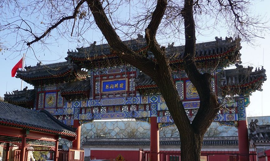
## Description The Taoist White Cloud Temple, also known as Baiyun Guan, is one of Beijing’s most important Taoist sites and one of the best places in the city to understand living religious tradition rather than imperial grandeur alone. Unlike the palaces and ceremonial complexes that often dominate Beijing itineraries, White Cloud Temple offers a quieter, more introspective experience centered on worship, ritual practice, and the continuity of Taoist culture in a modern metropolis. It is both a spiritual site and a historic monument, and that combination gives it a distinct atmosphere that feels deeply local. One of the reasons the temple stands out is that it has remained an active religious center for centuries. Visitors are not just looking at preserved architecture; they are entering a place where incense, prayer, and seasonal observance still matter. A lesser-known fact is that Baiyun Guan has long been associated with the Quanzhen school of Taoism, which helped shape its role as a major center for priestly training and ritual life. Another detail many travelers miss is that the temple complex includes multiple courtyards and halls arranged to guide visitors gradually from the street into a more contemplative inner space, which makes the visit feel like a transition rather than a simple sightseeing stop. For travelers, the appeal lies in both scale and texture. The temple is not overwhelming, yet it contains enough detail to reward slow observation. You will see ritual objects, stone inscriptions, prayer spaces, architectural ornament, and the quiet habits of worshippers who come for reasons unrelated to tourism. That authenticity matters. It gives White Cloud Temple a grounded energy that many visitors find memorable precisely because it is not trying to entertain them. Instead, it invites attention, patience, and respect. It is also an excellent introduction to Taoism for visitors who know the tradition only in abstract terms. The site demonstrates how religion, philosophy, architecture, and daily practice can coexist in one living space. In a city famous for imperial landmarks, White Cloud Temple offers a more intimate kind of historical depth. ## Location Taoist White Cloud Temple is located in Xicheng District, Beijing, China, not far from the central part of the city. Its placement makes it accessible without being swallowed by the busiest tourist corridors. Because Beijing is so large, that central-but-not-overcrowded location is a major advantage for visitors who want to combine the temple with other nearby cultural stops. The easiest way to reach the temple is by subway followed by a short walk, although taxis and rideshares are also practical. Public transit is usually the most efficient option in Beijing, especially during heavy traffic. Once you arrive, the temple is straightforward to enter, and the surrounding streets make it easy to transition from city noise into a quieter courtyard environment. If you want to build the visit into a broader Beijing day, it works well as part of a route that includes nearby historic neighborhoods, museums, or old city streets. Morning visits are often the best because the temple feels calm, the light is better for photography, and you are more likely to encounter ritual activity rather than only sightseeing crowds. ## Tips Dress modestly and behave respectfully. This is an active religious site, not just a museum. Arrive early if you want a quieter experience. The temple’s atmosphere is strongest before the day becomes too busy. Look closely at the courtyards and side halls. The most rewarding details are often not in the main entrance area but in the quieter corners. Bring cash or a card depending on current local habits, but do not assume every small purchase or offering will be handled the same way as in a Western museum setting. Take time to observe rather than rush through the complex. Baiyun Guan is best experienced as a slow walk through layered religious space. ## Conclusion The Taoist White Cloud Temple is one of Beijing’s most meaningful spiritual landmarks, combining active worship, historical continuity, and architectural calm. It is especially rewarding for travelers who want a more thoughtful and authentic view of the city. ## FAQ ### Is White Cloud Temple still active? Yes. It remains an active Taoist temple, which is part of what makes the visit so distinctive. ### How much time should I spend there? Most visitors will need 1 to 2 hours, though you can spend longer if you are interested in the history or want to observe the atmosphere more carefully. ### Is photography allowed? Policies can vary by area and current temple rules, so it is best to check on arrival and avoid photographing people without permission. ### Is this a good place for first-time visitors to Beijing? Yes, especially if you want to understand the city beyond its most famous imperial monuments. ## Links - [White Cloud Temple on Wikipedia](https://en.wikipedia.org/wiki/White_Cloud_Temple) - [Beijing official tourism](https://english.beijing.gov.cn/) - [Taoism overview](https://en.wikipedia.org/wiki/Taoism)
GemVoyage Team • World
Stockholm
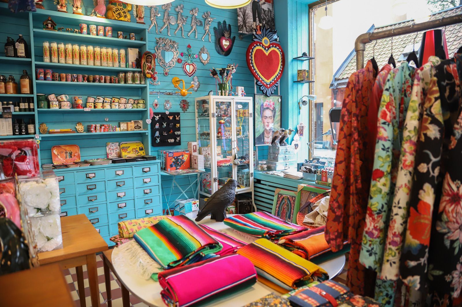
## Description Södermalm has a reputation as one of Stockholm’s most creative and self-assured districts, and its vintage shops are a big part of that identity. The area draws people who like fashion with history, pieces with character, and browsing that feels more like discovery than consumption. Unlike retail zones built around uniform shopping streets, Södermalm’s vintage scene is scattered through a district that already feels interesting to walk through. That means the shopping experience is inseparable from the neighborhood itself. The appeal of Södermalm vintage shops is not only the clothes. It is the curation, the neighborhood energy, and the sense that the area has a long memory. Stockholm’s relationship with design, sustainability, and thoughtful consumption makes secondhand shopping feel especially natural here. You can find everything from well-preserved Scandinavian basics to statement pieces, accessories, workwear, and occasional design objects. Some shops specialize tightly; others feel like treasure hunts where the best finds appear when you least expect them. One little-known fact is that Södermalm’s secondhand culture is closely tied to the district’s broader reputation for indie creativity and alternative style. Another is that many visitors underestimate how pleasant the neighborhood is for walking between shops. Even when one store is busy, the next street might feel calm, which keeps the experience relaxed and exploratory rather than transactional. For travelers who enjoy fashion but dislike generic mall shopping, this is an especially good environment. There is also a practical advantage. Vintage shopping in Södermalm can be combined with cafés, viewpoints, galleries, and neighborhood walks, so the district never feels like a single-purpose retail stop. It becomes part shopping outing, part urban exploration, and part cultural snapshot of Stockholm itself. The result is a richer visit than simply buying clothes. You are also seeing how locals shape style, reuse, and everyday city life. ## Location The vintage shops are located across Södermalm, an island district in central Stockholm, Sweden. Södermalm sits south of Gamla Stan and is one of the easiest central areas of Stockholm to explore on foot. The shopping spots are spread through several streets and pockets of the district, so the experience works best when you treat it as a neighborhood walk rather than a fixed single destination. The easiest way to reach Södermalm is by Stockholm’s metro system, bus network, or on foot from the city center. Medborgarplatsen, Slussen, and other nearby stations are practical starting points depending on which part of the district you want to explore. Because the best finds are often spread out, a comfortable pair of shoes helps more than a tightly scheduled plan. If you are visiting in winter, plan for shorter daylight hours and use indoor stops such as cafés to break up the walk. In warmer months, the district is especially pleasant because moving between shops feels almost like a mini city tour in itself. ## Tips - Start with a broad walk through the district before committing to specific shops. That helps you understand the neighborhood layout. - Look for quality as much as price. The best vintage pieces in Stockholm often stand out because of condition, cut, and timeless design. - Bring a reusable bag or extra room in your luggage if you plan to buy clothing or small home items. - Pair shopping with coffee or lunch so you can pace yourself and avoid rushed decisions. - Visit more than one shop style. A good vintage outing in Södermalm usually mixes curated boutiques, thrift stores, and neighborhood secondhand spots. ## Conclusion Södermalm’s vintage shops offer more than shopping. They give you a stylish way to experience one of Stockholm’s most characterful districts while discovering clothing and objects that feel personal, sustainable, and distinctly local. ## FAQ ### Is Södermalm good for vintage shopping even if I am not a fashion expert? Yes. The neighborhood is easy to browse casually, and many stores are approachable even if you are not hunting for something specific. The pleasure is as much in the atmosphere as in the purchase. ### Are the shops expensive? Prices vary a lot. Some stores are highly curated and price pieces accordingly, while others are more affordable. Stockholm generally has a reputation for quality over bargain-bin pricing. ### How much time should I set aside? At least a few hours if you want to enjoy the area properly. The best experience comes from mixing browsing with time for walking, coffee, and neighborhood exploration. ### Can I combine vintage shopping with other sightseeing? Definitely. Södermalm is close to scenic viewpoints, restaurants, and central Stockholm landmarks, so it fits easily into a larger city day. ## Links - [Södermalm on Wikipedia](https://en.wikipedia.org/wiki/S%C3%B6dermalm) - [Visit Stockholm](https://www.visitstockholm.com/)
GemVoyage Team • World
Karachi
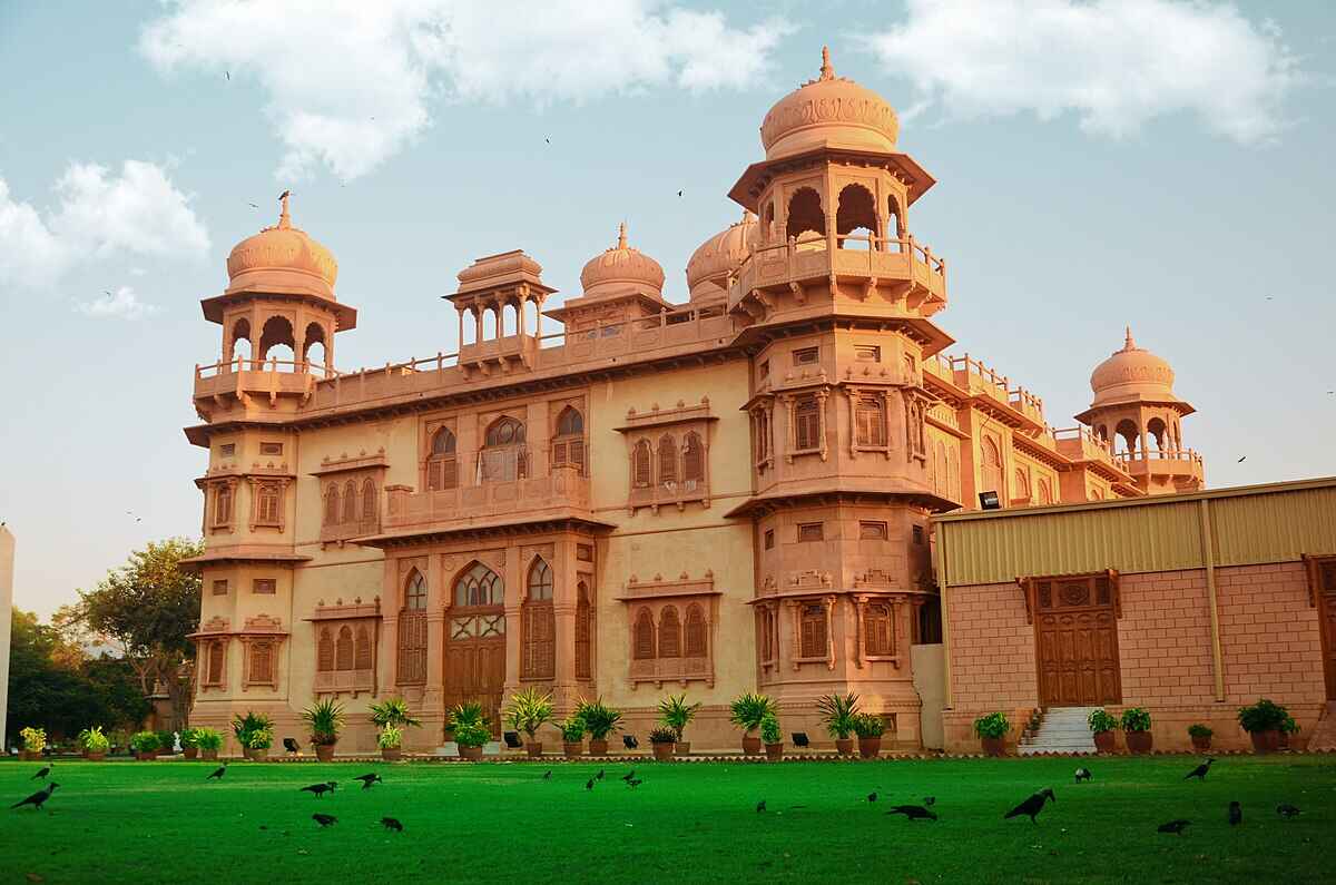
## Description Mohatta Palace is one of Karachi’s most iconic architectural gems, blending history, culture, and artistry into a single breathtaking experience. Built in 1927 by Shivratan Chandraratan Mohatta, a wealthy Hindu Marwari businessman, the palace was originally intended as a summer retreat. Designed by architect Agha Ahmed Hussain, it showcases the Indo-Saracenic style, combining elements of Mughal and Rajasthani architecture. The structure is made of pink Jodhpur stone and local yellow Gizri stone, giving it a warm, regal glow that stands out in the heart of Clifton. The palace spans over 18,500 square feet and features nine domes, intricately carved windows, floral motifs, and a grand central dome that crowns the building. Inside, visitors find polished teak wood staircases, long corridors, and stately rooms that once hosted lavish gatherings. Today, Mohatta Palace functions as a museum, hosting exhibitions that celebrate Pakistan’s rich artistic and cultural heritage—from miniature paintings and textiles to contemporary art installations. A little-known fact: the palace once housed a private temple dedicated to Lord Shiva on its rooftop terrace, a quiet reminder of its original owner's spiritual life. Another intriguing detail is the presence of secret underground tunnels, rumored to have been used for discreet movement during political unrest—though these remain closed to the public. ## Location Mohatta Palace is located in **Karachi**, the largest city in **Pakistan**, within the **Sindh** province. Specifically, it sits in the upscale neighborhood of **Old Clifton**, at 7 Hatim Alvi Road, Block 5. ### How to Get There: - **By Car**: Easily accessible via Shahrah-e-Faisal or the Clifton Bridge. Parking is available nearby. - **By Public Transport**: Local buses and ride-hailing services like Careem and Uber can drop you off directly at the entrance. - **From Jinnah International Airport**: The palace is about a 45-minute drive depending on traffic. For tourists, hiring a local guide or joining a heritage tour can enhance the experience with historical context and insider stories. ## Tips for Visitors To make the most of your visit to Mohatta Palace, keep these tips in mind: - **Check Exhibition Schedules**: The museum hosts rotating exhibitions, so check ahead to catch something that aligns with your interests. - **Photography**: While photography is allowed in the gardens, it’s restricted inside the museum. Ask staff for permission if you're documenting your visit. - **Dress Comfortably**: The palace grounds are expansive, and Karachi’s climate can be warm—light clothing and comfortable shoes are recommended. - **Visit Early**: Arriving early helps avoid crowds and gives you time to explore the gardens and nearby attractions. - **Guided Tours**: Opt for a guided tour to uncover stories and architectural details you might otherwise miss. - **Cultural Etiquette**: Respect the museum’s quiet ambiance and avoid loud conversations or disruptive behavior. ## Conclusion Mohatta Palace is more than a historical building—it’s a living museum that bridges the past and present of Pakistan’s cultural identity. With its stunning architecture, rich history, and vibrant exhibitions, it offers a unique and enriching experience for anyone visiting Karachi. ## FAQ **1. What are the opening hours of Mohatta Palace?** Typically, the museum is open from 11:00 AM to 6:00 PM, Tuesday to Sunday. It’s closed on Mondays and public holidays. **2. Is there an entry fee?** Yes, a nominal fee is charged for entry. Discounts may be available for students and groups. **3. Can I take photos inside the palace?** Photography is allowed in the gardens but restricted inside the museum. Always check with staff before taking pictures. **4. Are guided tours available?** Yes, guided tours are available and highly recommended for a deeper understanding of the palace’s history and exhibitions. **5. Is Mohatta Palace wheelchair accessible?** Accessibility is limited due to the historic nature of the building. It’s best to contact the museum in advance for specific accommodations. **6. What kind of exhibitions are held at Mohatta Palace?** Exhibitions range from traditional arts and crafts to contemporary visual art, often highlighting themes of heritage, identity, and social change. ## Links - [Mohatta Palace Official Website](https://mohattapalacemuseum.org/) - [Wikipedia – Mohatta Palace](https://en.wikipedia.org/wiki/Mohatta_Palace)
GemVoyage Team • World
Sintra
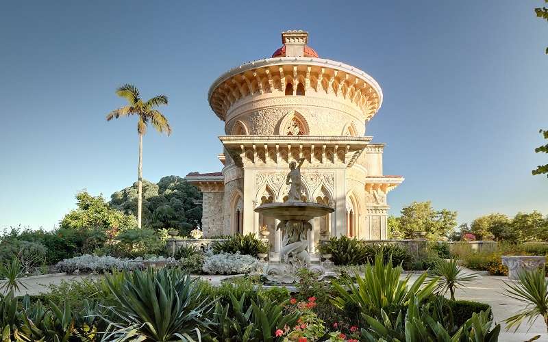
## Description Monserrate Palace in Sintra is one of Portugal’s most exquisite and underrated architectural treasures. Nestled in the lush hills of the Serra de Sintra, this 19th-century palace is a masterpiece of Romanticism, blending Gothic, Moorish, and Indian architectural styles into a harmonious and visually captivating whole. Commissioned by Sir Francis Cook, a wealthy English art collector, the palace was designed as a summer retreat and reflects his eclectic taste and fascination with exotic cultures. The palace’s interior is a feast for the eyes, with intricately carved marble columns, lace-like stonework, and domed ceilings inspired by Islamic architecture. The Music Room, with its ornate plasterwork and acoustics, is particularly striking and occasionally hosts cultural events. Surrounding the palace is a sprawling botanical garden that features species from all over the world, including a Mexican garden, a Japanese garden, and a rose garden. These gardens were carefully curated to reflect the Victorian passion for exotic landscaping and offer a tranquil escape into nature. A little-known fact: Monserrate was once the home of William Beckford, an eccentric English novelist and art collector, before it was transformed by Francis Cook. Another fascinating detail is that the palace and its gardens were used as a filming location for the NBC miniseries “Gulliver’s Travels,” starring Ted Danson. ## Location Monserrate Palace is located in **Portugal**, in the **Lisbon District**, within the **city of Sintra**. It lies approximately 3.5 kilometers west of Sintra’s historic center, in the heart of the Sintra-Cascais Natural Park. ### How to Get There - **By Train**: From Lisbon, take the train from Rossio Station to Sintra. The journey takes about 40 minutes. - **By Bus**: From Sintra station, take bus 435 (the Villa Express) which stops at Monserrate Palace, as well as other key attractions like Quinta da Regaleira. - **By Car**: Driving from Lisbon takes around 45 minutes. Parking is available near the palace. - **By Tuk-Tuk or Taxi**: Local tuk-tuks and taxis offer scenic rides from Sintra’s center to Monserrate. Its slightly off-the-beaten-path location means it’s often quieter than Sintra’s more famous palaces, making for a more relaxed visit. ## Tips - **Visit Early or Late**: To enjoy the gardens and palace with fewer crowds, aim for early morning or late afternoon. - **Wear Comfortable Shoes**: The gardens are extensive and include uneven paths, so sturdy footwear is recommended. - **Bring a Camera**: The architectural details and lush landscapes are incredibly photogenic. - **Use the Map**: The ticket includes a map of the gardens—use it to explore hidden corners like the Fern Valley and the ruins of the chapel. - **Combine with Nearby Attractions**: Monserrate pairs well with a visit to Quinta da Regaleira or a hike in the Sintra-Cascais Natural Park. - **Check for Events**: Occasionally, concerts and exhibitions are held in the Music Room—check the schedule in advance. ## Conclusion Monserrate Palace is a stunning fusion of art, architecture, and nature. With its exotic design, peaceful gardens, and rich history, it offers a unique and serene alternative to Sintra’s more crowded landmarks. ## FAQ **1. What are the opening hours of Monserrate Palace?** The park is open from 9:00 AM to 7:00 PM, and the palace from 9:30 AM to 6:00 PM. Last admission is 30 minutes before closing. **2. What is the entrance fee?** Adult tickets cost €12, youth (6–17) €10, and seniors €6.50. Children under 6 enter free. **3. Is Monserrate Palace suitable for children?** Yes, the gardens are great for families, though supervision is recommended due to uneven terrain. **4. Can I buy tickets online?** Yes, tickets can be purchased through the official Parques de Sintra website or authorized vendors. **5. Is the palace wheelchair accessible?** The palace has limited accessibility due to its historic structure. The gardens have some accessible paths. **6. How long should I plan for a visit?** Allow 1.5 to 2 hours to explore both the palace and the gardens thoroughly. ## Links - [Official Park and Palace of Monserrate Website](https://www.parquesdesintra.pt/en/parks-monuments/park-and-palace-of-monserrate/)
GemVoyage Team • World

Comments