GemVoyage Team • World
Arènes de Lutèce is one of Paris’s most unexpected and historically significant sites: a Roman amphitheater hidden in plain sight within the Latin Quarter. Dating back to the 1st century CE, it is among the oldest surviving monuments in the city and a rare physical reminder of Lutetia, the Gallo-Roman settlement that preceded modern Paris.
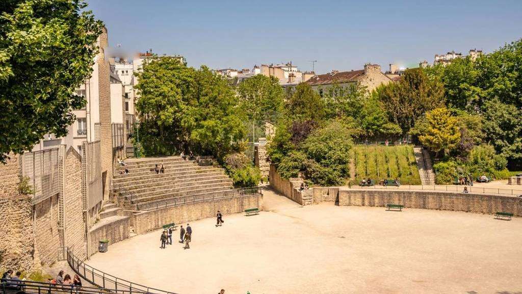
Unlike the grand, fully preserved amphitheaters of southern France or Italy, the Arènes de Lutèce is fragmentary, modest in scale, and deeply embedded in its urban surroundings. This is precisely what makes it compelling. The remains include portions of the arena floor, tiered seating, subterranean chambers, and traces of the stage wall. In its prime, the amphitheater could accommodate up to 15,000 spectators, hosting gladiatorial combats, animal hunts, and theatrical performances.
What sets the Arènes de Lutèce apart is its history of disappearance and rediscovery. After the fall of the Roman Empire, the structure was gradually dismantled and buried beneath medieval buildings. By the Middle Ages, its existence was largely forgotten. It was not rediscovered until the 19th century during urban works, and even then, much of it was threatened by redevelopment. The site was ultimately saved following public campaigns supported by prominent cultural figures, including Victor Hugo.
A lesser-known fact is that the amphitheater served multiple secondary purposes over time. During the Middle Ages, stones from the structure were reused in nearby buildings, effectively dissolving it into the fabric of the city. Another overlooked detail is that today’s visible remains represent only a fraction of the original structure; much of it still lies beneath surrounding streets and buildings, preserved underground rather than reconstructed.
Today, the Arènes de Lutèce functions as a public space rather than a formal museum. Locals play pétanque on the arena floor, children run along the ancient stone seating, and visitors sit quietly where Roman spectators once gathered. This coexistence of daily life and antiquity is rare in Paris and gives the site a lived-in authenticity that no curated exhibition could replicate.
Country: France
Region: Île-de-France
City: Paris
Arrondissement: 5th (Latin Quarter)
The Arènes de Lutèce is located between Rue Monge and Rue de Navarre, in one of Paris’s most historic and intellectually rich neighborhoods.
* Line 7 to Place Monge, then a 3–5 minute walk.
* Line 10 to Cardinal Lemoine, followed by a short walk.
* Several bus lines serve the Latin Quarter and stop nearby.
* Easily reachable from the Panthéon, Jardin des Plantes, or the Seine’s Left Bank.
* Bike lanes and public bike stations are available in the area.
The Arènes de Lutèce is a rare example of ancient history woven directly into the rhythm of modern urban life. Quiet, understated, and profoundly authentic, it offers a powerful reminder that Paris did not begin in the Middle Ages, but in the Roman world beneath its streets.
1. Is there an entrance fee?
No, entry to the Arènes de Lutèce is free.
2. How old is the amphitheater?
It dates back to the 1st century CE.
3. How long should I spend there?
Around 20 to 40 minutes, depending on interest.
4. Is it a reconstructed site?
No, it consists of original remains with minimal restoration.
5. Is it suitable for children?
Yes, it is an open and informal space often used by families.
6. Why is it not better known?
Its modest size and lack of monumental reconstruction keep it off many tourist itineraries.
Discover more hidden gems you might love.
Pakistan
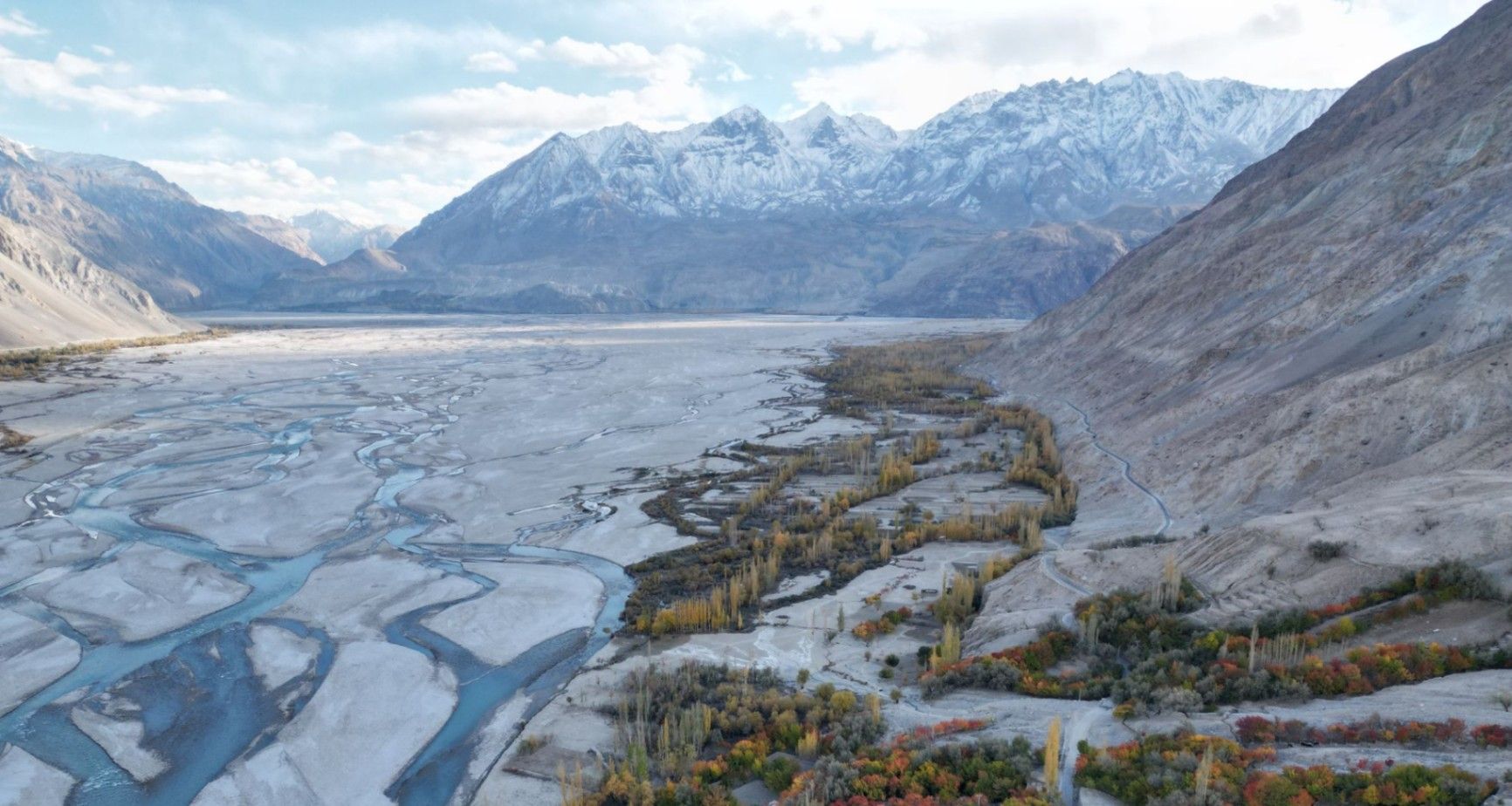
## Description **Nangma Valley**, located in northern Pakistan’s Gilgit-Baltistan region, is a breathtaking alpine valley that remains one of the country’s best-kept secrets. Renowned for its majestic granite spires, lush meadows, and pristine alpine landscapes, Nangma Valley is a paradise for trekkers, climbers, and photographers. What sets Nangma Valley apart is its untouched natural beauty and relative seclusion compared to more famous destinations like Hunza or Skardu. The valley is dotted with soaring rock towers—some over **5,000 meters** high—making it one of the premier destinations for **rock climbing and mountaineering** in Pakistan. Peaks such as **K7**, **K6**, and **Amin Brakk (the “Great Tower”)** have attracted world-class climbers from around the globe, yet the area still retains its peaceful, uncommercialized character. A lesser-known fact about Nangma Valley is that it is often referred to as **the “Yosemite of Pakistan”**, thanks to its sheer granite walls and the way sunlight paints the cliffs golden at dawn and dusk. The valley is also home to small Balti villages, where visitors can experience traditional hospitality and life in one of the most remote corners of the world. ## Location Nangma Valley lies in **Gilgit-Baltistan**, in the **Karakoram Range** of **northern Pakistan**, near the town of **Hushe** in the **Ghangche District**. It is about 130 kilometers east of **Skardu**, the main gateway to the region. To reach Nangma Valley, travelers first fly or drive to **Skardu**—flights from Islamabad are the most common route, taking about an hour (weather permitting). From Skardu, a scenic drive of approximately 5–6 hours leads to Hushe Village, from where the trek to Nangma Valley begins. The trek itself is moderate and usually takes around **3–4 hours** on foot, passing through alpine pastures and along a clear glacial stream. ## Tips * **Best time to visit:** The valley is most accessible between **June and September**, when the weather is mild, and the snow has melted. * **Pack for mountain weather:** Even in summer, temperatures can drop sharply at night. Warm layers and a sleeping bag are essential. * **Bring proper trekking gear:** Good hiking boots, walking poles, and waterproof clothing are highly recommended. * **Hire local guides and porters:** The Balti guides are knowledgeable about routes, weather, and local customs, and hiring them supports the local economy. * **Camping:** There are several scenic camping sites, such as at the base of Amin Brakk and near the Nangma Glacier. Always follow Leave No Trace principles. * **Photography:** Sunrise and sunset offer the best light for photographing the granite spires and surrounding peaks. * **Acclimatize properly:** Even though Nangma Valley is not at extreme altitude, gradual acclimatization helps prevent altitude sickness. ## Conclusion **Nangma Valley** is a hidden gem for those seeking adventure, solitude, and awe-inspiring mountain scenery. Its towering granite peaks, green meadows, and crystal-clear streams make it one of the most spectacular yet underexplored trekking destinations in Pakistan. Whether you’re an experienced climber or a nature lover looking for tranquility, Nangma Valley promises a journey deep into the heart of the Karakoram’s beauty and serenity. ## FAQ **1. Where is Nangma Valley located?** It’s in Gilgit-Baltistan, near Hushe Village in the Ghangche District, approximately 130 km from Skardu. **2. How do I reach Nangma Valley from Islamabad?** You can fly to Skardu (around 1 hour) or take a 20–22 hour drive via the Karakoram Highway. From Skardu, continue by jeep to Hushe and then trek into the valley. **3. Do I need a trekking permit?** No official permit is required for Nangma Valley itself, but registering with local authorities or the Hushe tourism office is recommended. **4. Is the trek difficult?** The trek to the main campsites is moderate, suitable for most fit travelers. Climbers aiming for higher peaks will need advanced equipment and experience. **5. Can I find accommodation nearby?** Basic guesthouses are available in Hushe Village. In the valley, visitors usually camp or stay in tents arranged by local guides. **6. Is Nangma Valley safe for tourists?** Yes. The valley is peaceful, and local communities are known for their warm hospitality. However, it’s best to travel with a guide and inform authorities of your plans. ## Links * [Pakistan Tourism Development Corporation](https://www.tourism.gov.pk) * [Adventure Pakistan – Trekking and Expeditions](https://www.adventurepakistan.com)
GemVoyage Team • World
Ostrava
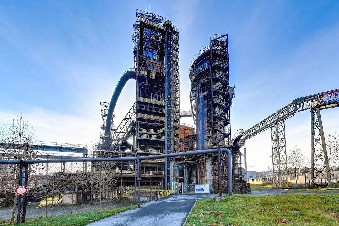
## Description The **Bolt Tower** is one of the most striking symbols of Ostrava, Czech Republic, blending modern architecture with the city’s rich industrial past. Rising from the remains of a former blast furnace at the **Lower Vítkovice industrial complex**, this futuristic structure stands as a testament to the city’s transformation from a coal and steel hub into a vibrant cultural destination. Completed in 2015, the tower was named after legendary Jamaican sprinter **Usain Bolt**, who personally attended the opening ceremony. With its sleek, glass-and-steel design perched atop an old furnace, Bolt Tower symbolizes speed, energy, and forward motion while preserving a strong connection to history. One of the most unique aspects of the tower is that it combines **modern architecture with industrial heritage**—a contemporary structure extending the life of a blast furnace that once powered the region’s economy. Inside, visitors can enjoy a panoramic café, exhibition spaces, and a sky-high observation deck that offers some of the best views in Ostrava. A little-known fact is that Bolt Tower reaches a total height of **77 meters**, making it the highest accessible point in Ostrava. Another interesting detail is that its construction was part of a broader effort to redevelop the Lower Vítkovice complex into a UNESCO-listed cultural and educational center, now hosting concerts, festivals, and exhibitions. ## Location Bolt Tower is located in the **Lower Vítkovice (Dolní Vítkovice) area** of **Ostrava**, the third-largest city in the **Moravian-Silesian Region of the Czech Republic**. The tower sits within the former industrial heart of the city, now transformed into a major cultural attraction. Getting there is straightforward. From **Ostrava’s city center**, the site is only about 2 kilometers away. Visitors can easily take a tram (line 1 or 2) to the **Dolní Vítkovice stop**, which is just a short walk from the tower. If traveling by train, Ostrava’s **hlavní nádraží (main station)** is a quick 10-minute ride by public transport. For international visitors, Ostrava is accessible by train from Prague, Brno, or Kraków, and the **Leoš Janáček Airport** is just 20 kilometers away. ## Tips Here are some helpful tips to make your visit to Bolt Tower more enjoyable: * **Book tickets in advance** – Especially during weekends or events at Lower Vítkovice, the observation deck and café can get busy. * **Visit in the evening** – The city lights at night create a spectacular view, and the tower itself is beautifully illuminated. * **Dress appropriately** – The observation deck is open-air, so it can get windy, especially in autumn and winter. * **Combine with a tour of Lower Vítkovice** – Don’t miss the guided tours of the former blast furnaces and other industrial sites nearby. * **Enjoy the café** – The tower’s café offers not just drinks and snacks, but also a relaxing atmosphere with unbeatable views. * **Check the events calendar** – Lower Vítkovice often hosts concerts, exhibitions, and festivals, which can make your visit even more special. ## Conclusion The **Bolt Tower in Ostrava** is more than just a lookout point—it’s a bold symbol of transformation and renewal. By combining modern design with the remains of a historic blast furnace, it offers visitors a unique perspective on Ostrava’s past and future. Whether you come for the breathtaking views, the cultural experiences, or simply to enjoy a coffee above the city skyline, Bolt Tower is an unmissable highlight of the Czech Republic’s industrial heritage. ## FAQ **1. Why is it called Bolt Tower?** It was named after Usain Bolt, the world-famous sprinter, who attended the opening and symbolized speed and energy. **2. How tall is Bolt Tower?** The tower reaches a total height of 77 meters, making it the highest accessible point in Ostrava. **3. Can I visit the inside of the blast furnace as well?** Yes, guided tours of the Lower Vítkovice blast furnaces and industrial complex are available and highly recommended. **4. Is Bolt Tower family-friendly?** Absolutely. Children can enjoy the observation deck and the impressive industrial setting, though young kids should be supervised due to heights. **5. When is the best time to visit?** Late afternoon or evening is ideal for enjoying both daytime views and the city lights at night. **6. Do I need to buy a separate ticket for the café?** No, access to the café is included with the general admission ticket to Bolt Tower. ## Links * [Visit Ostrava – Tourism Information](https://www.visitostrava.eu)
GemVoyage Team • World
Sedgefield
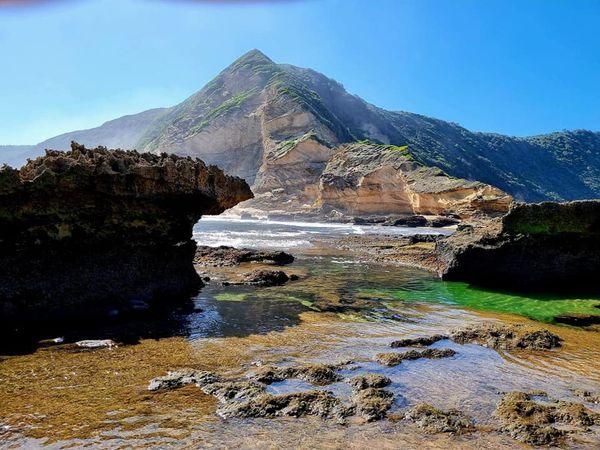
## Description **Gericke’s Point** is one of the hidden gems of South Africa’s Garden Route. Famous for its striking sandstone cliff that resembles the profile of a lion’s head, this natural landmark offers both geological beauty and incredible biodiversity. At low tide, the area transforms into a natural aquarium, revealing tidal pools brimming with colorful marine life such as starfish, sea anemones, and small fish. The rock formation itself is over 150 million years old, part of the ancient Table Mountain sandstone system. Its unusual shape and size make it one of the most photogenic spots along the coast. Beyond its geology, Gericke’s Point is also a birdwatcher’s paradise, with seabirds often seen diving for fish and dolphins occasionally passing offshore. A little-known fact is that the tidal pools here are considered some of the most diverse along the Garden Route, making it a favorite spot for marine biologists and nature enthusiasts. Another fascinating detail is that the rock face has long been a landmark for sailors navigating the coast between Sedgefield and Wilderness. ## Location Gericke’s Point is located near **Sedgefield**, a small town along the **Garden Route** in the **Western Cape Province** of **South Africa**. It lies about 25 kilometers from Knysna and around 40 kilometers from George. To reach the point, visitors typically start at Swartvlei Beach near Sedgefield. From there, a scenic beach walk of about 2–3 kilometers leads to the rock formation. The best time to go is at low tide, when the tidal pools are accessible and the walk is safe. Travelers driving the Garden Route can easily stop at Sedgefield, with parking available near the beach entrance. ## Tips * **Check the tide tables:** Low tide is the only safe and rewarding time to visit. High tide can make the walk dangerous. * **Wear sturdy shoes:** Although the walk is along the beach, exploring the tidal pools requires footwear with good grip. * **Bring a camera:** The lion-shaped rock formation and vibrant tidal pools make for excellent photography opportunities. * **Pack water and sun protection:** There are no facilities along the beach walk, so carry essentials with you. * **Respect marine life:** Avoid disturbing or removing creatures from the tidal pools—this is a fragile ecosystem. * **Stay for sunset:** The area is particularly stunning in the golden light of late afternoon, with the rock formation silhouetted against the ocean. ## Conclusion Gericke’s Point is more than just a rock formation—it is a window into South Africa’s geological past and a living showcase of coastal biodiversity. With its tidal pools, dramatic cliffs, and sweeping ocean views, it offers a perfect mix of adventure and tranquility along the Garden Route. For travelers seeking a memorable nature experience off the beaten path, Gericke’s Point is not to be missed. ## FAQ **1. How long is the walk to Gericke’s Point?** The walk from Swartvlei Beach to Gericke’s Point takes about 30–40 minutes each way, depending on pace and tide conditions. **2. Is it safe to swim near Gericke’s Point?** Swimming is possible in some tidal pools, but the open ocean can be rough. Always exercise caution and avoid strong currents. **3. Can children visit the point?** Yes, children often enjoy exploring the tidal pools, but they should be supervised closely due to slippery rocks and the incoming tide. **4. Is there an entrance fee?** No, Gericke’s Point is free to access, though parking at Swartvlei Beach may sometimes require a small fee. **5. What wildlife might I see?** In addition to tidal pool creatures, visitors may spot dolphins offshore, oystercatchers, and other seabirds. In whale season (June–November), southern right whales are sometimes visible. **6. When is the best time to visit?** The best time is at low tide and preferably in the morning or late afternoon when temperatures are milder and light conditions are ideal. ## Links * [Visit Garden Route – Sedgefield](https://www.visitgardenrouteandkleinkaroo.com) * [South African Tourism – Garden Route](https://www.southafrica.net)
GemVoyage Team • World
Vienna
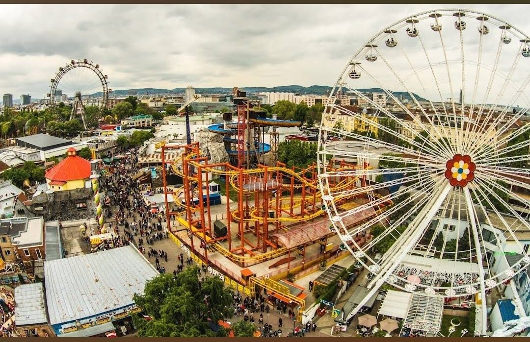
## Description **Prater Funpark** in Vienna, commonly referred to as the **Wurstelprater**, is one of Europe’s most iconic amusement parks and a beloved attraction for both locals and tourists. Nestled within the vast Prater public park, this funfair has been entertaining visitors for over 250 years. It’s a place where history, nostalgia, and modern thrills come together, offering everything from traditional carousels and bumper cars to cutting-edge roller coasters and high-adrenaline rides. What makes the Prater unique is its blend of old-world charm and contemporary entertainment. The park’s symbol, the **Wiener Riesenrad** (Giant Ferris Wheel), dates back to 1897 and is one of Vienna’s most recognized landmarks. Riding the Ferris wheel provides not only fun but also breathtaking panoramic views of the city. At the same time, newer attractions like turbo coasters and virtual reality experiences ensure that thrill-seekers are never bored. **Little-known facts**: * The Prater was originally an imperial hunting ground before being opened to the public in 1766. The amusement park grew organically from stalls, performers, and small rides. * Unlike most theme parks, **entry to the Prater Funpark is free**. Visitors pay only for the rides and attractions they choose, making it a flexible experience for all budgets. --- ## Location Prater Funpark is located in **Vienna**, the capital of **Austria**, within the **Leopoldstadt district**. It sits inside the larger **Prater public park**, a green oasis that stretches over six square kilometers and also includes walking paths, meadows, and sports facilities. ### How to get there: * **By metro**: The fastest way is to take the U1 or U2 subway lines to the station **Praterstern**, which is just a short walk from the park. * **By tram**: Trams 0 and 5 also stop near Prater. * **By foot or bike**: Visitors staying in central Vienna can enjoy a scenic walk or bike ride to the park, as it’s close to the city center. --- ## Tips * **Visit in the evening**: The Prater comes alive after sunset when the rides light up, creating a magical carnival atmosphere. * **Don’t miss the Giant Ferris Wheel**: It’s the park’s most famous attraction and a must for first-time visitors. * **Plan your budget**: Since entry is free but rides are paid individually, decide beforehand how many attractions you’d like to try. Ride prices vary, so bringing cash can be useful. * **Try the local food stalls**: Beyond rides, the park is known for its traditional Austrian snacks like bratwurst, pretzels, and candied nuts. * **Combine with a stroll in the Prater park**: After the excitement of the rides, the surrounding green spaces offer a relaxing contrast. * **Check seasonal events**: The park hosts festivals, concerts, and themed events throughout the year, especially during summer and around Christmas. --- ## Conclusion Prater Funpark in Vienna is more than just an amusement park—it’s a cultural institution that blends history, fun, and nostalgia. With its mix of historic attractions like the Wiener Riesenrad and thrilling modern rides, it offers something for everyone, from families to adrenaline junkies. Whether you go for the rides, the food, or the atmosphere, the Prater promises an unforgettable Viennese experience. --- ## FAQ **1. Is there an entrance fee for Prater Funpark?** No, entrance is free. Visitors only pay for the rides and attractions they choose. **2. What is the most famous ride at Prater?** The **Wiener Riesenrad (Giant Ferris Wheel)** is the park’s most iconic attraction and a symbol of Vienna. **3. When is the best time to visit?** Evenings are particularly magical with illuminated rides, but daytime visits are better for families with young children. **4. How long should I plan to spend at Prater?** Most visitors spend 2–4 hours, though you could easily spend a whole day enjoying the rides and the larger Prater park. **5. Is Prater open year-round?** The park is open all year, but many rides operate seasonally, typically from March to October. The Giant Ferris Wheel and some attractions remain open in winter. **6. Can I find food and drinks inside the park?** Yes, the park is filled with restaurants, snack stalls, and beer gardens serving Austrian and international food. --- ## Links * [Prater Wien – Official Website](https://www.praterwien.com/) * [Wiener Riesenrad – Official Website](https://www.wienerriesenrad.com/)
GemVoyage Team • World
Lahore
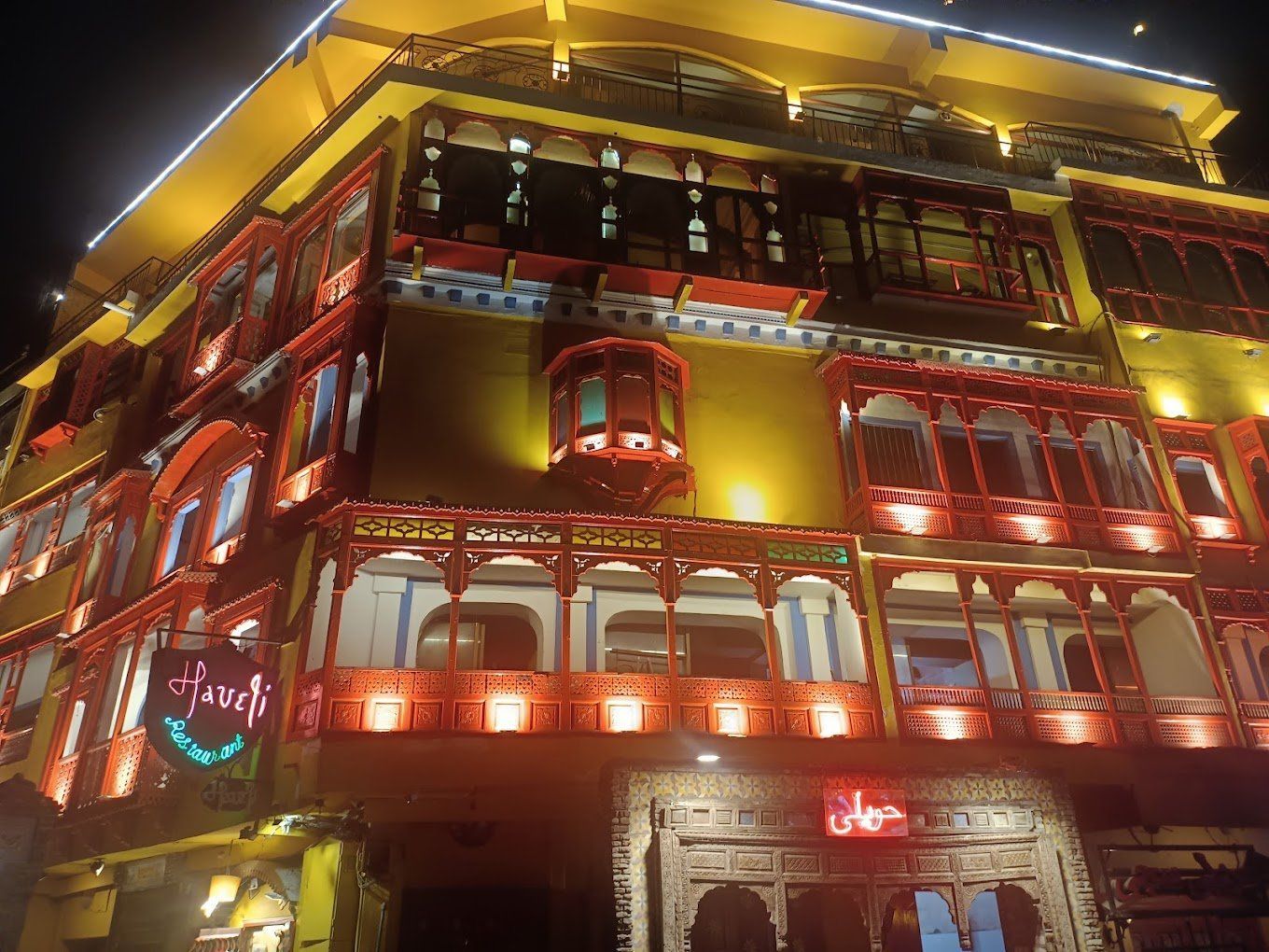
## Description Haveli Restaurant on Lahore Food Street is one of the city’s most atmospheric dining destinations, especially for visitors who want a meal that also feels like an introduction to Lahore’s historic soul. The appeal is not only the food, though the menu is certainly part of the draw. The real magic is the setting: a restored or heritage-inspired space overlooking some of the most iconic sights of the old city, where a meal can come with views of the Badshahi Mosque, Lahore Fort, and the surrounding historic district. In a city known for hospitality and strong culinary traditions, Haveli stands out because it turns dinner into a panoramic cultural experience. What makes the restaurant memorable is how it channels the feeling of old Lahore without turning it into a sterile theme. The ambiance is warm, lively, and often bustling, with families, groups of friends, and travelers all sharing the same multi-level experience. A little-known fact is that the restaurant’s rooftop seating has become one of the most photographed dining settings in Lahore, especially at sunset or after dark when the historic skyline is lit. Another detail many first-time visitors do not expect is how much the surrounding food street contributes to the overall visit. Arriving here is not just about sitting down for a meal; it is about entering a wider evening rhythm where lights, aromas, and street activity all frame the experience. The food itself usually reflects the rich comfort cuisine that Lahore is famous for: grilled meats, curries, bread, rice dishes, and the sort of generously spiced meals that work especially well after a day spent exploring the old city. Even travelers who are mostly interested in architecture or history often leave remembering the restaurant because it connects the city’s cultural identity with a simple and satisfying act: eating well in a beautiful place. ## Location Haveli Restaurant is on or near Lahore Food Street in the historic old-city area of Lahore, Punjab, Pakistan, close to the major heritage zone around the Badshahi Mosque, Lahore Fort, and the old fort-road corridor. The location makes it especially convenient for travelers already visiting the Walled City, because it fits naturally into an evening route through Lahore’s most famous monuments. The easiest way to reach it is usually by taxi or rickshaw, followed by a short walk into the food street area. Because the old city can be crowded and the roads can feel busy, it is best to approach the area with some flexibility in your timing. Sunset is a particularly strong moment to arrive, since it gives you enough daylight for the approach and enough evening atmosphere for the meal itself. If you are making a special trip, consider combining it with a mosque or fort visit earlier in the day, then moving to the restaurant for dinner when the temperature and light are more comfortable. ## Tips - Reserve or arrive early if you want the best rooftop tables. - Sunset is often the most rewarding time for both photos and atmosphere. - Plan a little extra time for the walk around Food Street before or after your meal. - Try signature local dishes rather than ordering too broadly. - Dress respectfully, especially if you are moving between heritage sites and dinner. - Use the restaurant as part of a larger old-city evening rather than a standalone stop. ## Conclusion Haveli Restaurant is one of Lahore’s most appealing places for visitors who want food, heritage, and views in the same experience. It captures the mood of the old city while offering a memorable and scenic meal. ## FAQ ### Is Haveli Restaurant good for tourists? Yes. It is especially good for travelers who want a dinner setting tied to Lahore’s historic atmosphere. ### What is the best time to go? Sunset and early evening are usually the most impressive times. ### Is rooftop seating worth it? Yes. The rooftop views are one of the main reasons people choose this restaurant. ### Can I combine it with sightseeing? Absolutely. It fits perfectly after visiting the Walled City, Lahore Fort, or the Badshahi Mosque. ## Links - [Lahore Food Street information](https://walledcitylahore.gop.pk/) - [Wikipedia on Lahore](https://en.wikipedia.org/wiki/Lahore) - [Badshahi Mosque](https://en.wikipedia.org/wiki/Badshahi_Mosque)
GemVoyage Team • World
Griva
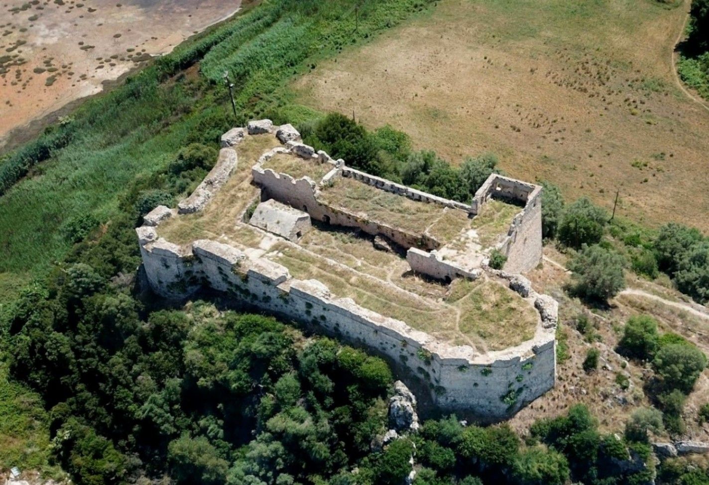
## Description **Griva Castle** (Κάστρο Γρίβα) is a lesser-known but historically significant fortress perched on a ridge in the region of Central Greece. Unlike Greece’s major medieval castles that attract heavy tourism, Griva Castle stands out for its **raw ruins, unfiltered atmosphere, and panoramic vantage point** over the surrounding mountains and valleys. The site is largely untouched by large-scale restoration efforts, which preserves an authenticity that appeals to explorers, hikers, and history enthusiasts seeking off-the-beaten-path destinations. The castle’s origins date back to the **Ottoman period**, when the structure served as a fortified outpost controlling local routes and offering surveillance over the strategic landscape. Its position was not chosen for grandeur but for **tactical visibility**; from the top of the hill, occupants could observe movements across the region long before they reached nearby settlements. Today, visitors can still walk along the remnants of its stone walls, towers, and defensive perimeters, all while imagining the military operations that once shaped the area. A little-known fact is that the castle area was later used during the **Greek War of Independence**, serving as a refuge and observation point for local fighters resisting Ottoman rule. Another interesting detail is that small-scale excavations have revealed architectural traces suggesting earlier defensive uses, which may predate the Ottoman era. What sets Griva Castle apart is the **simplicity of the experience**. There are no curated exhibitions, no ticket booths, and no commercial vendors. Instead, you step into a quiet, windswept landscape that has retained its historic atmosphere. The lack of crowds makes it ideal for slow-paced exploration, photography, and reflection. With clear weather, the views are expansive, capturing rural settlements, forested hillsides, and rolling terrain that highlight the natural beauty of central Greece. ## Location **Country:** Greece **Region:** Central Greece (Sterea Ellada) **Nearest Town:** Griva or surrounding villages depending on the specific approach The castle sits atop a hill overlooking the local countryside, accessible through rural roads and small village paths. ### How to Get There * **By car:** * The most practical option. Rural roads lead to the village area, from which a short uphill walk brings you to the castle ruins. A standard vehicle is usually sufficient, but some paths may be uneven. * **By bus:** * Limited. Regional buses connect nearby towns, but reaching the castle itself generally requires private transport. * **On foot:** * Hiking paths from the village allow visitors to reach the castle in about 15–25 minutes depending on the route chosen. * **By guided tour:** * Occasional historical or hiking groups include the site, but these are not frequent. ## Tips * **Wear proper footwear:** The terrain is rocky, uneven, and sometimes slippery after rain. * **Visit during daylight:** The area has no lighting, and navigating the ruins after sunset is unsafe. * **Bring water and snacks:** There are no facilities near the castle. * **Check the weather:** Clear skies enhance the views significantly and make the hike easier. * **Combine the visit with nearby villages:** Traditional tavernas in surrounding settlements are ideal for a post-hike meal. * **Photography enthusiasts should visit during golden hour:** The light over the surrounding hills is excellent. ## Conclusion Griva Castle is a quiet, rugged, and historically rich destination that rewards visitors willing to venture beyond mainstream tourist circuits. Its ruins, elevated position, and connection to regional history make it a compelling stop for those seeking authentic Greek landscapes and immersive outdoor exploration. ## FAQ **1. Is there an entrance fee?** No. The site is freely accessible to visitors. **2. Are the ruins safe to explore?** Generally yes, but caution is essential due to uneven paths and the absence of barriers. **3. How long does the visit take?** Most visitors spend **45 minutes to 1.5 hours** depending on hiking time and interest. **4. Is it suitable for children?** Only with supervision. Some sections have steep drops and loose stones. **5. Are guided tours available?** Occasionally, especially by local history or hiking groups, but not regularly. **6. What is the best time of year to visit?** Spring and early autumn offer comfortable temperatures and clear views. ## Links * [Greek tourism information](https://visitgreece.gr)
GemVoyage Team • World

Comments