Discover extraordinary places shared by our community of travelers
Norway
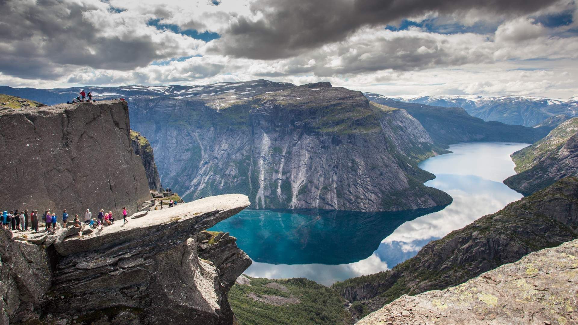
## Description Trolltunga (“Troll’s Tongue”) is one of Norway’s most photographed and dramatic viewpoints: a narrow rock shelf jutting horizontally from a mountain about 700 meters above Ringedalsvatnet lake near Odda. The slab provides a heady vantage point for daring photos — standing at the lip feels like stepping out over the fjord and valley below. The route to Trolltunga is an epic alpine hike across tundra, streams and exposed plateaus, rewarding determined trekkers with panoramic Norway: steep cliffs, glassy water and a raw northern landscape. Beyond the photogenic ledge, Trolltunga stands out for its demanding yet accessible backcountry experience. The modern popularity surged through social media; traditionally, this was a remote local hike. Management measures, permits, and local transport services have evolved to handle seasonal traffic while protecting the path and surrounding vegetation. ## Location Trolltunga sits above the town of Odda in Vestland county, western Norway. The usual trailhead is at Skjeggedal, accessed by a short shuttle from parking and visitor centers. Many hikers base themselves in Odda or nearby villages and use local shuttles or guided hiking operators to reach the trailhead. The total round-trip hike is roughly 22–28 kilometers depending on route, often taking 10–12+ hours for a typical day trip. Seasonality matters: roadside parking and trail access are managed during summer to reduce environmental impact and improve safety. In winter and shoulder seasons the route becomes technical and requires winter mountaineering skills and equipment. ## Tips - **Prepare for a long day:** Bring layers, a warm waterproof jacket, sturdy boots, plenty of food, and ample water. The trail is long with sustained elevation gain and exposed terrain. - **Start early or plan an overnight:** To avoid peak crowds and to allow a relaxed pace, begin pre-dawn or plan an overnight in a mountain cabin or campsite. Early starts also improve light for photography and reduce the chance of afternoon weather changes. - **Choose guided or self-guided based on experience:** Guided hikes add local knowledge and reduce navigation stress; experienced hikers can plan self-guided excursions but should be disciplined with timing. - **Respect safety and common-sense rules:** The ledge has no formal barriers. Avoid risky poses near the edge, especially in windy or wet conditions. Keep children close and prioritize safety over photographs. - **Pack for changing conditions:** Tundra and plateau weather can shift quickly. Bring a waterproof shell, insulating mid-layer, hat and gloves even in summer. A headlamp, spare batteries, and a basic repair kit for footwear are helpful. - **Leave no trace:** Stay on marked trails to protect vegetation, pack out all waste, and follow any local guidance about camping and trail use. - **Consider alternatives for accessibility:** For those unable to complete the full hike, photo viewpoints and shorter trails in the region offer dramatic scenery with less effort. ## Conclusion Trolltunga is an emblem of Norway’s wild beauty and an achievement for hikers — the dramatic viewpoint and sweeping fjord panoramas make the long approach worthwhile for those prepared for a sustained mountain day. With thoughtful preparation and respect for local rules, the route rewards visitors with some of Scandinavia’s most iconic views and a memorable sense of accomplishment. ## FAQ - **Q: How difficult is the hike to Trolltunga?** A: The route is long and strenuous with sustained elevation and exposed terrain. It suits fit hikers with good preparation; novices should consider guided options or shorter nearby hikes. - **Q: How long does the hike take?** A: Typical round-trip time is 10–12+ hours for 22–28 kilometers depending on fitness and conditions. Allow extra time for photography and rest stops. - **Q: Can you camp on the route?** A: Wild camping is practiced in Norway but follow local regulations and Leave No Trace principles. Some guided itineraries include overnight options or staged hut-to-hut plans. - **Q: Are there safety services or mountain rescue?** A: Mountain rescue services exist regionally, but mobile coverage can be patchy. Going with a guide or letting someone know your itinerary improves safety; carry basic emergency gear. - **Q: When is the best time to hike Trolltunga?** A: Summer (June–September) is the primary hiking season with milder weather and long daylight. Shoulder seasons require careful planning; winter requires mountaineering skills. - **Q: Is the viewpoint crowded?** A: Popular times can be crowded, especially mid-morning in summer. Start early for quieter conditions and better light. ## Links - [Trolltunga — Wikipedia](https://en.wikipedia.org/wiki/Trolltunga)
GemVoyage Team • World
Grindavik
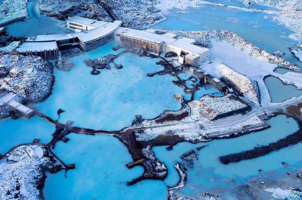
## Description The Blue Lagoon near Grindavík is one of Iceland’s most famous geothermal spas, renowned for its vivid milky-blue waters set against a rugged lava field. The warm seawater is rich in silica, minerals and microalgae, which give it a distinctive color and reputed skin-soothing properties. The man-made lagoon originated from the runoff of a nearby geothermal power plant, and over time it evolved into a carefully managed spa destination with curated bathing experiences, spa treatments and striking architecture integrated into moss-covered lava. What makes the Blue Lagoon feel special is its blend of high-design hospitality and raw volcanic surroundings: sleek facilities, in-water bars and silica mud treatments meet black lava and open sky. The lagoon is also a refined wellness experience — many visitors combine a soak with spa treatments, saunas and skin clinics that use the lagoon’s mineral-rich waters. ## Location The Blue Lagoon sits in the Reykjanes Peninsula near the town of Grindavík, southwestern Iceland, about a 20–25 minute drive from Keflavík International Airport (KEF) and roughly 45–50 minutes from Reykjavík. Its close proximity to the airport makes it an ideal stop for arrival or departure itineraries. Shuttles, organized transfers and private cars serve the site; many travelers build a visit into a layover or the first/last day of an Icelandic road trip. ## Tips - **Pre-book tickets:** The Blue Lagoon operates on a timed-entry ticket system and often sells out. Book your preferred time slot and any spa treatments in advance, especially during peak travel seasons. - **Combine with airport logistics:** For arrivals or departures, plan luggage storage, transit time and transport options carefully — factor in check-in windows if you’re catching an onward flight. - **Choose the right package:** Packages range from basic entry to premium experiences with robes, transfers and exclusive lounge access. Compare what’s included — towels and robes may be part of higher-tier options. - **Use silica mud and spa treatments mindfully:** The silica mud masks are iconic, but be cautious with sensitive skin types. Follow staff guidance and rinse thoroughly after treatment. - **Protect electronics and valuables:** Bring a waterproof phone case and use on-site lockers for valuables. The lagoon environment can fog camera lenses and corrode metal accessories over time. - **Respect spa etiquette and hygiene:** Shower thoroughly before entering, follow lifeguard instructions, and avoid bringing food into the water. Keep noise levels moderate to preserve the spa atmosphere. - **Consider time of day for photos:** Early morning or late afternoon light yields softer colors and fewer crowds; sunrise visits can be striking but check opening hours and transfers. ## Conclusion The Blue Lagoon is an accessible and cinematic geothermal spa experience that pairs Iceland’s volcanic drama with high-quality wellness amenities. Whether you stop for a long layover soak, a restorative spa day, or a luxury treatment, the lagoon’s mineral-rich waters and dramatic setting create a memorable contrast to urban travel or long flights. ## FAQ - **Q: Can I visit the Blue Lagoon on arrival or departure from KEF?** A: Yes — the Blue Lagoon’s proximity to Keflavík International Airport makes it popular for arrivals and departures. Allow extra time for transfers and check-in when booking around flights. - **Q: Do I need to book in advance?** A: Strongly recommended. Timed-entry tickets can sell out, especially in high season. Book online to secure your preferred slot and any additional treatments. - **Q: Is swimming allowed in the lagoon?** A: Bathing in the designated pools is the main activity. Supervised areas and lifeguards may be present; follow posted safety rules. - **Q: Are there age restrictions or family options?** A: Children are allowed in many ticket types but check current policies on age limits and supervision requirements. Family-friendly times and facilities vary by package. - **Q: Is the water natural and safe for skin?** A: The lagoon’s water is managed and replenished; it’s mineral-rich and generally safe for most skin types, but those with severe skin conditions should consult a physician before bathing and test briefly. - **Q: What should I bring?** A: For basic visits bring swimwear, a waterproof phone case, and comfortable clothes for changing. Higher-tier packages may include towels and robes. ## Links - [Blue Lagoon — Official site](https://www.bluelagoon.com)
GemVoyage Team • World
Denizli
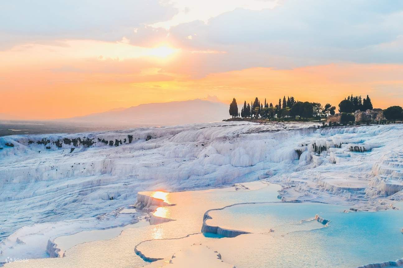
## Description Pamukkale — literally “cotton castle” in Turkish — is an otherworldly landscape of gleaming white travertine terraces and thermal pools near Denizli in southwestern Turkey. Formed over millennia by mineral-rich hot springs, the cascading calcium carbonate deposits have created terraced basins that look like frozen waterfalls. Beyond their striking beauty, the terraces have been a center of bathing and healing since antiquity; the nearby Greco-Roman spa city of Hierapolis thrived here and left ruins that add historical depth to the site. What makes Pamukkale unique is this fusion of geology, thermal waters and preserved ancient architecture: you can soak in warm waters while gazing across white steps that sparkle under the Mediterranean sun and then wander through the atmospheric ruins of a Roman necropolis and theatre. Conservation measures have redirected water flows over the decades to protect fragile formations while allowing controlled access for visitors. ## Location Pamukkale is located in Denizli Province, in Turkey’s Aegean region. It sits roughly 20 kilometers north of the city of Denizli and about a 3–4 hour drive from Izmir depending on route. The easiest way to reach Pamukkale is to fly into Denizli Çardak Airport (DNZ) or Izmir Adnan Menderes (ADB) and then take a shuttle, rental car, or bus to Pamukkale town. Many visitors base themselves nearby and make day trips to the terraces and Hierapolis archaeological site. ## Tips - **Visit early or late to avoid crowds:** The terraces are most photogenic in soft morning or late-afternoon light and less crowded at those times. Midday can be busy and harshly lit. - **Follow conservation rules:** Walking barefoot on protected terraces is required in some zones — shoes and grit can damage delicate carbonate layers. Use designated paths and restricted areas to protect the formations. - **Combine with Hierapolis:** Buy a combined ticket to explore the Hierapolis archaeological site and its museum; the ancient thermal bath ruins and the Roman theatre add cultural context to the natural spectacle. - **Bring swimwear and a towel for designated pools:** Some thermal pools and nearby hotel facilities allow bathing. The Cleopatra Pool (within Hierapolis) is an example where supervised bathing is permitted for a fee. - **Protect your skin and eyes:** The bright white terraces reflect intense sunlight. Sunglasses, broad-spectrum sunscreen and a hat are important for comfort and safety. - **Choose comfortable footwear for approaches:** While you may walk barefoot on terraces in protected areas, approaches and surrounding paths benefit from supportive shoes. - **Respect local signage and staff instructions:** Conservation authorities and staff provide guidance to ensure the formations remain intact for future visitors. ## Conclusion Pamukkale is a rare combination of dramatic natural formation and rich archaeological heritage. Whether you come for the thermal waters, the photographic vistas, or the silence of ancient stones, the site offers an unforgettable sensory experience rooted in landscape and history. Visitors who honor conservation measures will help keep these terraces pristine for future generations. ## FAQ - **Q: Is Pamukkale safe to visit?** A: Yes — it’s a well-visited UNESCO World Heritage site with clear conservation rules and tourist facilities. Stay on marked paths and follow signage. - **Q: Can I swim in the terraces?** A: Swimming is allowed only in designated pools and some supervised areas; many terraces are closed to bathing to protect them. The Cleopatra Pool at Hierapolis is one supervised option. - **Q: How long should I plan for a visit?** A: Allocate 2–4 hours to walk the terraces, visit Hierapolis and see the museum — longer if you plan to bathe or explore additional local attractions. - **Q: When is the best time to visit Pamukkale?** A: Spring and autumn offer pleasant temperatures and fewer crowds. Early morning or late afternoon provides the best light for photography and cooler conditions for walking barefoot. - **Q: Are there entrance fees?** A: Yes, entry to the terraces and Hierapolis requires a ticket; combined tickets commonly include both sites and vary by season and operator. - **Q: Is Pamukkale wheelchair accessible?** A: Accessibility is improving in some areas, but many terraces have uneven surfaces and steps. Check current access options with local tourism offices if mobility is a concern. ## Links - [Pamukkale — Wikipedia](https://en.wikipedia.org/wiki/Pamukkale)
GemVoyage Team • World
Zhangjiajie
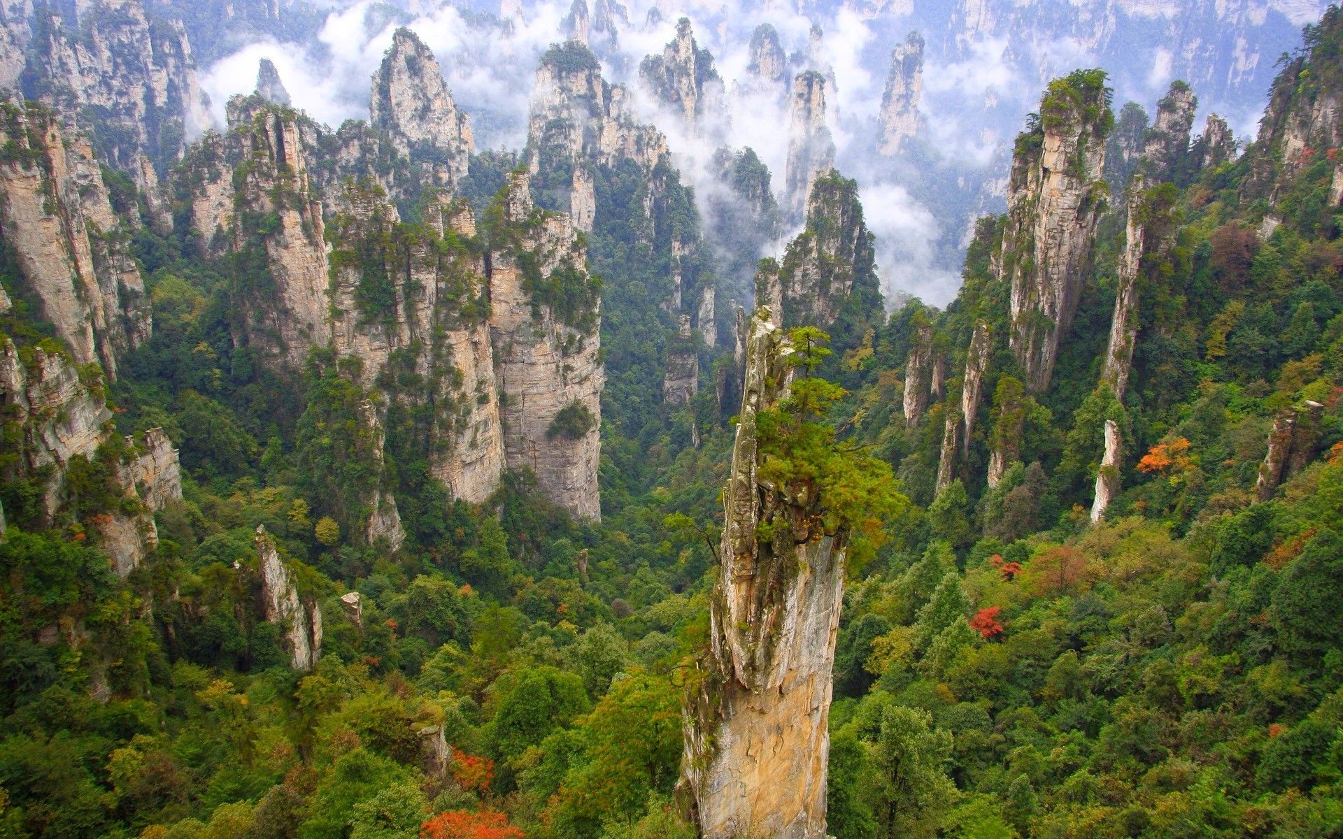
## Description Wulingyuan Scenic Area, centered near Zhangjiajie city in China’s Hunan province, is a vertiginous landscape of thousands of sandstone pillars, sheer cliffs, gorges, and forests that seem to rise like petrified sentinels from the mist. These dramatic quartz-sandstone pillars — sculpted by millions of years of weathering and tectonic uplift — inspired the floating Hallelujah Mountains in the film Avatar and have long been celebrated by Chinese poets and painters. The area’s allure is its scale and verticality: narrow natural bridges, deep ravines, and needle-like pillars draped in evergreen vegetation create a sense of being dwarfed by primeval geometry. A network of footpaths, glass walkways, cable cars and elevators lets visitors move through different elevations to appreciate viewpoints and remote valleys. Wulingyuan comprises several distinct sub-areas including Zhangjiajie National Forest Park, Suoxiyu Nature Reserve, and Tianzi Mountain, each with signature vantage points and trails. Wulingyuan is an immersive mosaic of vertical landforms and biodiverse temperate forests. The interplay between rock, vegetation and mist creates atmospheric conditions that shift hourly, offering photographers and hikers a constantly changing tableau. The park's infrastructure — from the high skywalks to rock-cut staircases — helps visitors access dramatic overlooks that would otherwise require arduous climbs, but there are still plenty of routes for travelers who prefer quieter, off-the-beaten paths. Birdlife, small mammals and a variety of endemic plants add ecological interest; in certain seasons wildflowers carpet the valley floor while winter brings frosted pinnacles that refract morning light. Planning matters: popular viewpoints can be crowded during national holidays and summer weekends, and logistics such as cable-car lines and internal shuttle flows are part of the visiting experience. For those seeking solitude, early mornings, shoulder seasons and walking lesser trails can reveal the park's raw character with fewer people. Local towns provide convenient bases with accommodations, and combining a stay in Zhangjiajie with nearby rural villages or other Hunan attractions creates a richer regional itinerary. ## Location Wulingyuan is in Zhangjiajie, Hunan province, China. The nearest major rail and bus connections lead to Zhangjiajie city (Dixian), and Zhangjiajie Hehua Airport (DYG) connects with several Chinese cities. From Zhangjiajie city, shuttle buses and local transport convey visitors to park entrances and scenic points. Transport within the scenic area often relies on park shuttle buses, cable cars and walking paths. Timetables can vary by season, so allow buffer time in itineraries and consider guided day trips if you prefer efficient routing across multiple highlights. Hotels in Zhangjiajie town range from budget to upscale and can coordinate tickets, transfers and optional guided hikes. ## Tips - **Plan for varied mobility:** The park includes steep steps, cable cars and some accessible boardwalks; allocate extra time for internal transfers and queues. - **Visit scenic highlights early:** Popular viewpoints such as Yuanjiajie and the Glass Bridge can be crowded; early starts reduce congestion and deliver softer light. - **Respect designated trails:** Stay on marked paths to protect fragile cliff-edge plant communities and avoid accidents. - **Consider off-season visits:** Spring and autumn offer dramatic mist and color with fewer tourists; summer can be humid and busy. - **Bring a good camera with zoom:** Many features are best photographed from a distance at different elevations; a telephoto helps capture layered pillars. - **Buy tickets in advance during holidays:** Entry volumes are controlled during peak periods — booking ahead reduces queuing time. - **Combine cable cars and walking strategically:** Use lifts to reach high viewpoints and walk descents to see quieter terrain. - **Pack rain gear and good soles:** Trails can be slick, and mist is common even in summer — non-slip shoes and a lightweight rain shell are helpful. - **Respect local wildlife:** Keep distance from animals and avoid feeding to maintain natural behaviors. ## Conclusion Wulingyuan’s towering pillars and swirling mists offer a dramatic encounter with geological time and vertical wilderness. Whether you’re exploring via cable car or tracing cliffside boardwalks, the sense of scale and detail here is unforgettable. The many faces of Wulingyuan — from misty dawn to sunlit pinnacles and frosted winter ridgelines — make it a destination that rewards repeat visits and patient observation. Thoughtful planning and off-peak travel can turn a crowded attraction into a personal experience of primeval vertical landscapes. ## FAQ - **Q: Is Wulingyuan suitable for non-hikers?** - A: Yes — cable cars and elevators provide access to many viewpoints, though some sites still require short walks. - **Q: How many days are recommended?** - A: 2–3 days is typical to see the main scenic areas without rushing. - **Q: Is there English signage and guides?** - A: Major points have some English information; hiring a bilingual guide improves cultural and geological context. - **Q: What’s the best time to visit for mist and atmosphere?** - A: Early morning and shoulder seasons often provide the most atmospheric mist and fewer crowds; autumn and spring are particularly rewarding. - **Q: Are the glass walkways safe?** - A: They meet safety standards and are maintained, but follow staff instructions and visitor limits to ensure safety. - **Q: Can I visit on a budget?** - A: Yes — use public transport, budget lodgings in Zhangjiajie town, and plan self-guided walks to reduce costs. - **Q: Are there accessibility options for visitors with reduced mobility?** - A: Some cable cars and elevated platforms offer improved access, though many trails have steps; check with local operators for tailored assistance. ## Links - [Wulingyuan — Wikipedia](https://en.wikipedia.org/wiki/Wulingyuan)
GemVoyage Team • World
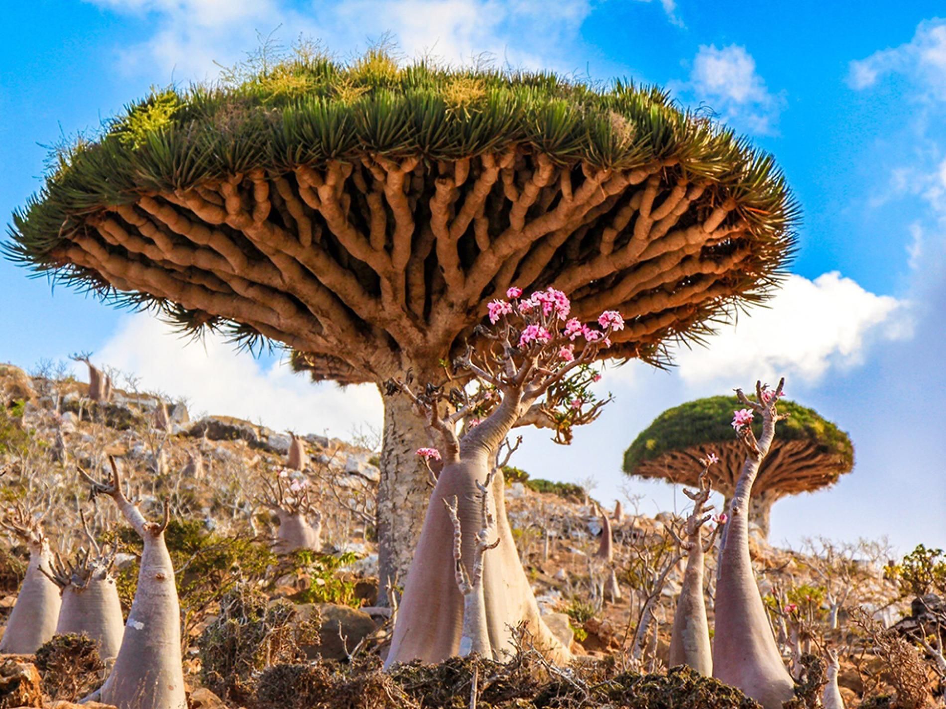
Socotra
## Description Socotra Island feels like a fragment of another planet — a remote, windswept archipelago in the northwest Indian Ocean whose flora and landscapes defy easy comparison. Part of Yemen’s Socotra Archipelago, the island is famed for its unique biodiversity: roughly one-third of its plant species are endemic, meaning they occur nowhere else on Earth. The emblematic dragon’s blood tree (Dracaena cinnabari) with its umbrella-like silhouette and deep red sap has become a symbol of Socotra’s otherworldly charm. Across the island, landscapes alternate between bizarre limestone plateaus, dramatic sea cliffs, windswept sand flats and pristine white-sand beaches framed by coral reefs. The experience of Socotra is defined by its isolation. Thousands of years of relative climatic stability have allowed life to evolve along separate lines, producing a cast of plants and small reptiles adapted to arid conditions and shallow soils. Visitors remark on the sculptural shapes and strange textures of the vegetation: bulbous succulents, twisted bottle trees, and dense thorny thickets that host endemic birds and invertebrates. This is a place for slow observation — botanizing on rock-strewn plateaus, watching seabirds along cliffs, and learning how local communities have adapted pastoral and fishing traditions to the island’s rhythms. Beyond flora and fauna, Socotra offers an immersive cultural layer. The island’s towns and villages, led by the main hub of Hadibo, display a traditional way of life that blends Bedouin pastoralism with fishing and small-scale commerce. Over the past decade eco-tourism has grown carefully: small guesthouses and locally guided tours emphasize conservation and community benefit. For the adventurous traveler the island’s remote tracks, sea caves and beaches promise solitude and dramatic light, perfect for landscape photography, contemplative walking and quiet wildlife encounters. ## Location Socotra is located in the northwest Indian Ocean, administratively part of Yemen, lying closer to the Horn of Africa than to the Arabian mainland. The island’s primary settlement and logistical hub is Hadibo (sometimes spelled Hadibu) on the northern coast. Historically, reaching Socotra has required careful planning: flights are limited and schedules change with political and logistical conditions. When available, small charter flights connect Socotra with mainland Yemen and, occasionally, regional hubs; sea access — via carefully arranged boat charters or local vessels — is an alternative for those with flexible timing. Because access can be intermittent, most independent travelers book through experienced operators who handle permits, inter-island travel, and local liaison. Visitors should check visa requirements and entry permits well in advance, and factor in contingency days for travel delays. Once on the island, Hadibo serves as the staging point for day trips inland to the Dixam Plateau, the Hagghier Mountains, and coastal excursions to remote beaches and snorkeling sites. ## Tips - **Check travel advisories and logistics:** Socotra’s access and safety status can change with regional developments. Before planning, consult official travel advisories, contact tour operators, and verify flight or sea schedules. Leave buffer days in your itinerary for unexpected delays. - **Use licensed local guides and operators:** Knowledgeable local guides are essential for navigating rocky tracks, interpreting plant life, and arranging transport to remote sites. Hiring local guide services supports the economy and ensures respectful interaction with communities. - **Respect fragile ecosystems:** Much of Socotra’s ecology is fragile. Stick to established tracks, avoid trampling vegetation, do not remove plants or geological material, and use minimal-impact camping practices. - **Pack for varied conditions:** Inland plateaus and mountains can be hot and dry during the day and chilly at night; coastal winds can be strong. Bring sun protection, sturdy hiking boots, a light windproof layer, and a reusable water bottle with a reliable purification method. - **Plan photography and drone use carefully:** Drones may be restricted to protect wildlife and privacy. Always ask local guides about regulations and cultural sensitivities before using camera equipment. - **Health and safety:** Medical facilities on Socotra are basic. Carry a well-stocked first-aid kit, any personal medications, and consider travel insurance with emergency evacuation coverage. Be up to date on routine vaccinations and check for recommended travel vaccines. - **Support local communities:** Choose guesthouses and guides that employ local staff, buy produce and crafts locally, and respect local dress and customs in villages. ## Conclusion Socotra is a destination for travelers who seek radical otherness and ecological rarity. Its alien plant forms, remote beaches, and quiet villages offer an experience both humbling and exhilarating — a reminder of how geographic isolation shapes life in remarkable ways. Thoughtful visitors who arrive well-prepared will find a landscape rich with photographic opportunities, quiet hiking routes, and meaningful encounters with local people and culture. Above all, Socotra rewards patience: time spent watching a dragon’s blood tree silhouette against the sky, or exploring a limestone plateau at dusk, lingers long after the trip ends. ## FAQ - **Q: Is Socotra safe to visit?** A: Safety and access can vary with regional and political conditions. Check up-to-date government travel advisories, consult experienced operators who run tours to Socotra, and register your travel plans with your embassy when appropriate. - **Q: How long should I spend on Socotra?** A: A well-paced visit typically runs 6–10 days. This allows time to explore the Dixam Plateau, the Hagghier Mountains, coastal beaches and a few village visits without feeling rushed. - **Q: When is the best time to visit Socotra?** A: The most comfortable travel window is during the cooler months, roughly October through April. Monsoon-related weather and hot summer temperatures can make travel more difficult in other months. - **Q: Can I arrange independent travel or do I need a tour operator?** A: Because flights and permits are limited, most travelers use reputable operators who arrange logistics, guides and permits. Independent travel is possible but requires local contacts and contingency planning. - **Q: What should I bring for wildlife and landscape photography?** A: Bring a mid-range zoom lens, a wide-angle for landscapes, a sturdy tripod for low-light work, spare batteries and memory cards, and neutral-density filters for coastal long exposures. - **Q: Are there accommodations and food options on the island?** A: Hadibo has small guesthouses and basic restaurants; expect simple but hearty local meals. For remote camping or multi-day excursions, operators typically supply food and equipment — confirm details beforehand. ## Links - [Socotra — Wikipedia](https://en.wikipedia.org/wiki/Socotra)
GemVoyage Team • World
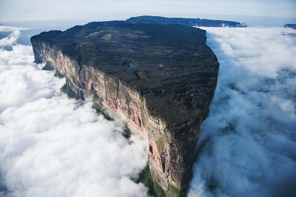
Gran Sabana
## Description Mount Roraima is a striking tabletop tepui — a flat-topped sandstone mesa — rising abruptly from the Gran Sabana plateau along the Venezuela–Brazil–Guyana border. Immensely atmospheric, its sheer cliffs and mist-shrouded summit inspired Arthur Conan Doyle’s The Lost World; the summit supports endemic plants and sculptural rock formations carved by erosion and persistent cloud. Trekking to Roraima’s summit is an otherworldly journey through shifting ecosystems: savanna, tepui foothills, cloud forests and alien rocky plateaus dotted with carnivorous plants and primitive flora. What makes Roraima singular is its biology and geology: tepuis act as ecological islands where species evolved in isolation, resulting in endemic flora and fauna found nowhere else. The plateau’s quartzite sandstone and erosional patterns carve shallow sinkholes and intricate channels that collect rainwater, forming microhabitats. Visitors encounter oddly-shaped boulders, deep natural cisterns and ephemeral pools that support plant communities adapted to thin soils and high rainfall. Beyond science, the experience is sensory: mist and cloud sweep across the summit, light transforms the slick rock faces, and nights on the plateau can be cold and silvery. For many, the trek to Roraima — along river crossings, open savanna and jungle gullies — delivers a sense of expeditionary travel; the route requires multi-day camping and careful logistical planning. ## Location Mount Roraima sits in the Gran Sabana region of southeastern Venezuela (Canaima National Park), at the tri-border with Guyana and Brazil. Most treks begin from the Venezuelan side, with popular access points around Paraitepuy or via Canaima; flights to Canaima followed by drives and river transfers are common. Organizing a Roraima expedition requires permits, an experienced guide and coordination for river logistics and camping equipment. Given its border location, some itineraries approach Roraima from Guyana — these routes are less common for international visitors but viable for those with appropriate travel documents and local arrangements. Venezuelan-side treks are the classic choice and usually include boat transfers, vehicle rides across savanna, and multiple days of trekking culminating with the scramble onto the plateau. ## Tips - **Book with experienced operators:** Choose accredited guides or operators who handle permits, river logistics, and camping gear. The plateau’s remoteness demands reliable local knowledge and safety planning. - **Fitness and acclimatization:** The trek is physically demanding, often involving long days of walking across uneven terrain, river crossings and carrying a daypack while guides transport communal gear. Conditioning with endurance hikes and strength training helps. - **Pack for extremes:** Expect heavy rain, intense sun at low elevations, muddy jungle stretches and cool winds on the summit. Waterproof layers, quick-dry clothing, high-traction trekking boots, gaiters, and a warm down layer for nights on the plateau are essential. - **Protect electronics and paper maps:** Use dry bags for sleeping gear and phone/ camera protection; quick access to waterproof maps or offline GPS tracking improves navigation in jungle and savanna. - **Leave no trace:** Camp on durable surfaces, pack out all waste, and avoid disturbing endemic plants on the plateau. The tepui ecosystem is delicate and regenerates slowly. - **Plan for altitude and weather:** The plateau can be cold and windy; thermal layers for nighttime and sun protection for daytime are both necessary. Bring a reliable headlamp and spare batteries for early starts or late arrivals. - **Permits and border considerations:** Verify permit requirements, carry appropriate identification, and confirm whether your route crosses national borders — passports and travel documents must be in order. ## Conclusion Mount Roraima offers a genuine expedition into a primeval landscape where geology and isolated evolution create surreal scenery. For adventurous travelers, the tepui’s summit is both a physical challenge and a revelation in biodiversity. The trek is unforgettable for those who embrace its remoteness — mist-wrapped cliffs, otherworldly rock formations, and night skies uncluttered by light pollution create one of South America’s most singular natural experiences. ## FAQ - **Q: How long is the trek to Roraima’s summit?** A: Typical treks last 6–8 days round-trip, depending on route and pace. Some itineraries are longer if they include extra side excursions in the Gran Sabana or additional borderside logistics. - **Q: Is the trek technical or suitable for beginners?** A: The trek is non-technical in terms of climbing gear but is physically demanding and involves uneven, slippery surfaces and river crossings. Experienced guides can support less-experienced hikers, but a baseline of good fitness is important. - **Q: What permits or documents are required?** A: Permits vary by entry point and country. When approaching from Venezuela, arrange permits via a licensed operator; if approaching from Guyana or Brazil, confirm local regulations. Always carry valid ID and passport when near border areas. - **Q: When is the best time to trek Roraima?** A: The drier months (roughly December to April) are generally more manageable, but weather on tepuis can be unpredictable year-round. Avoid peak rainy periods when trails become more treacherous. - **Q: What wildlife and plant life should I expect?** A: Expect specialized endemic plants, carnivorous species like pitcher plants in microhabitats, and unique lichens and mosses on the summit. Larger wildlife is mostly absent on the plateau, but wildlife sightings are possible in the lowland savanna and rainforest approaches. - **Q: Is camping on the plateau comfortable?** A: Camping is rustic: bring a four-season or high-quality three-season tent and warm sleeping gear. Nighttime temperatures can drop sharply and winds can be strong. ## Links - [Mount Roraima — Wikipedia](https://en.wikipedia.org/wiki/Mount_Roraima)
GemVoyage Team • World
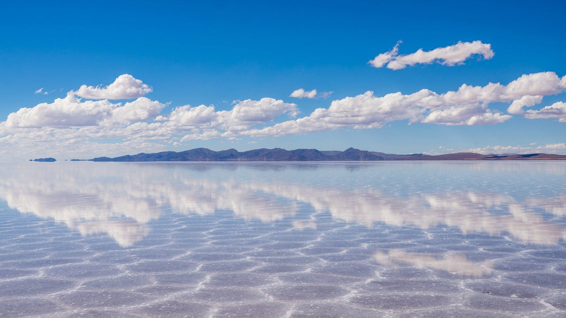
Uyuni
## Description The Salar de Uyuni in Bolivia is the world’s largest salt flat — an immense expanse of white crust stretching to the horizon. In the dry season it becomes a seemingly endless plain of hexagonal salt polygons; during the wet season, thin water turns the surface into a giant mirror that reflects sky and clouds in breathtaking panoramas. The flats’ surreal scale creates optical illusions that photographers exploit for creative forced-perspective shots and astronomical impressions. Uyuni’s uniqueness stems from its scale and seasonal transformation: an austere white desert that alternates between reflective glass and textured salt crust. Beneath the crust lie rich lithium brines that have become geopolitically important, and the region supports unique high-altitude wildlife including flamingos in nearby lagoons and vicuñas on the surrounding altiplano. A lesser-known feature is the train cemetery near Uyuni town, whose rusting locomotives echo the area’s industrial past against the vast natural backdrop. Visitors experience two very different seasons: the wet months (roughly December–April) turn the flats into a seamless mirror where the horizon disappears, producing surreal photographic opportunities; the dry months (May–November) reveal the networked hexagonal salt polygons and easier vehicle travel across firmer crust. Both seasons offer remarkable visual experiences, but logistics and vehicle access differ significantly. ## Location Salar de Uyuni is in southwest Bolivia near the town of Uyuni in Potosí Department. Most visitors begin in Uyuni and travel by 4x4 tours that range from day-trips to multi-day circuits visiting colored lagoons, hot springs, high-altitude deserts and remote salt hotels. ## Tips - **Choose season based on photographic goals:** Wet season for mirror reflections and dynamic sky photography; dry season for crisp salt polygons and easier driving conditions. - **Acclimatize and dress for altitude:** Uyuni sits over 3,600 m above sea level—allow time to adjust, stay hydrated and use sun protection. Nights are cold; warm layers are essential. - **Book reputable 4x4 operators and confirm vehicle safety:** Select experienced guides who understand remote driving, fuel logistics and high-altitude first aid. - **Plan for basic accommodations on multi-day tours:** Many overnight stops are simple lodges or salt hotels; bring essentials and respect eco-guidelines. - **Protect camera gear from salt and dust:** Use protective coverings, and clean equipment carefully after excursions to avoid salt corrosion. ## Conclusion Salar de Uyuni is an elemental landscape that redefines scale and reflection: a place where sky, salt and solitude combine to produce unforgettable visual experiences. Whether you chase inverted skies in the wet season or striding across crystalline salt in the dry months, Uyuni offers some of the planet’s most surreal and photogenic landscapes. ## FAQ - **Q: Can visitors drive across the Salar de Uyuni themselves?** A: Self-driving is possible but not recommended for first-time visitors—conditions vary, and poorly marked hazards or seasonal flooding can be dangerous. Use experienced local operators who know safe routes. - **Q: When is the best time for mirror reflections?** A: The wet season (roughly December–April) after rains produces the mirror effect; brighter skies and calm days improve reflections. - **Q: Will I experience altitude sickness at Uyuni?** A: Many travelers experience mild altitude effects; acclimatize in Uyuni or nearby towns, avoid heavy exertion on the first day and consider consulting a doctor if you have pre-existing health concerns. - **Q: Are there eco or cultural concerns to be aware of?** A: Respect fragile ecosystems and local communities; use operators who practice sustainable tourism and avoid leaving waste on the salt crust. - **Q: How many days do I need to appreciate the area?** A: Day trips are possible, but 3–4 day circuits are recommended to reach colored lagoons, hot springs and the Eduardo Avaroa reserve, giving a fuller, less rushed experience. ## Links - [Salar de Uyuni — Wikipedia](https://en.wikipedia.org/wiki/Salar_de_Uyuni)
GemVoyage Team • World
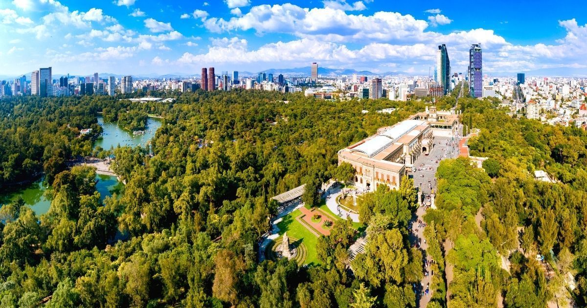
Mexico City
## Description Chapultepec Forest (Bosque de Chapultepec) is one of the largest and most consequential urban parks in the Americas, a living green lung at the heart of Mexico City that blends natural landscapes with civic life, culture, and history. More than a municipal park, Chapultepec is a multilayered cultural landscape: wide oak and pine groves, winding paths, boating lakes, formal gardens, archaeological sites, and a string of world-class museums make it a singular destination for both visitors and residents. Its scale and diversity mean you can shift within minutes from a quiet shaded trail to a museum day or a lakeside picnic, and that versatility is precisely what makes Chapultepec so valuable. Chapultepec's importance is historical as well as recreational. The hill that holds Chapultepec Castle was once an Aztec refuge and later a site of colonial and early republican power. The Castillo de Chapultepec offers sweeping views across the city and houses collections that relate to Mexico’s political story. Meanwhile, the National Museum of Anthropology and other cultural institutions in the park hold artifacts and exhibitions of global significance. The juxtaposition of high-culture museums and everyday park life—runners, families, vendors, and informal musicians—gives Chapultepec a dynamic sense of place that resists being reduced to a single label. From a traveler’s perspective, Chapultepec is best approached as a set of distinct neighborhoods. The first section concentrates major museums and tourist attractions; the second section contains quiet lawns and intimate groves used more by locals; the third section opens into larger, less manicured green areas with a calmer atmosphere. Each offers different rhythms: concentrated cultural learning, relaxed recreation, or more wilderness-like wandering. ## Location Chapultepec sits in central Mexico City, stretching west from Paseo de la Reforma into the adjacent neighborhoods of Polanco and Lomas de Chapultepec. It’s highly accessible: multiple metro stops and bus lines border the park and taxis or rideshares drop you close to major entrances. Because it’s integrated into the city rather than fenced off, think of Chapultepec as an urban zone with many points of entry rather than a single gated park. If your priorities are museums, start at the first section near the National Museum of Anthropology and the Museum of Modern Art. For boating and family activities, head to the lake area. For a quieter, more local experience, explore the second and third sections where joggers and picnickers are the dominant users. Allow travel time between sections if you plan to combine multiple activities. ## Tips - Prioritize: choose one or two zones (museums, lake and boats, or quiet groves) to avoid overambitious itineraries. - Start early: museums open mid-morning, and earlier starts beat crowds and heat. - Use public transit: nearby metro stations and eco-bus lines reduce parking hassles. - Wear layers and comfortable shoes: shaded groves can be cool while open plazas warm up quickly. - Pair the visit with neighborhood dining in Polanco or a stroll down Reforma for monuments and architecture. - Bring water, sunscreen, and small change for boat rentals and food stalls. ## Conclusion Chapultepec Forest is an essential part of a Mexico City visit because it combines culture, outdoor recreation, and historical depth in one central, walkable area. It’s best enjoyed with a focused plan—pick the experience that appeals most and accept that the park rewards repeat visits as much as one long day. ## FAQ ### Why is Chapultepec Forest so important? It combines large-scale green space, national museums, historical monuments, and everyday civic life in a single urban zone, making it central to Mexico City’s identity and visitor itineraries. ### Can I visit it in one afternoon? You can visit a focused part of Chapultepec in an afternoon—for example, Castillo de Chapultepec plus one museum—but seeing the whole park requires multiple visits. ### Is it family-friendly? Absolutely. The park has playgrounds, boat rentals, family-friendly museum exhibits, and wide lawns suitable for picnics and group activities. ### Are there museums inside the forest? Yes. Highlights include the National Museum of Anthropology, the Museum of Modern Art, Museo Tamayo, and Chapultepec Castle’s historic collections. ### What is the best way to explore it? Map one or two zones in advance, use public transit to arrive near those entrances, mix indoor and outdoor stops, and allow time to rest between high-intensity museum visits. ## Links - [Official website](https://www.chapultepec.org.mx/) - [Wikipedia](https://en.wikipedia.org/wiki/Chapultepec)
GemVoyage Team • World
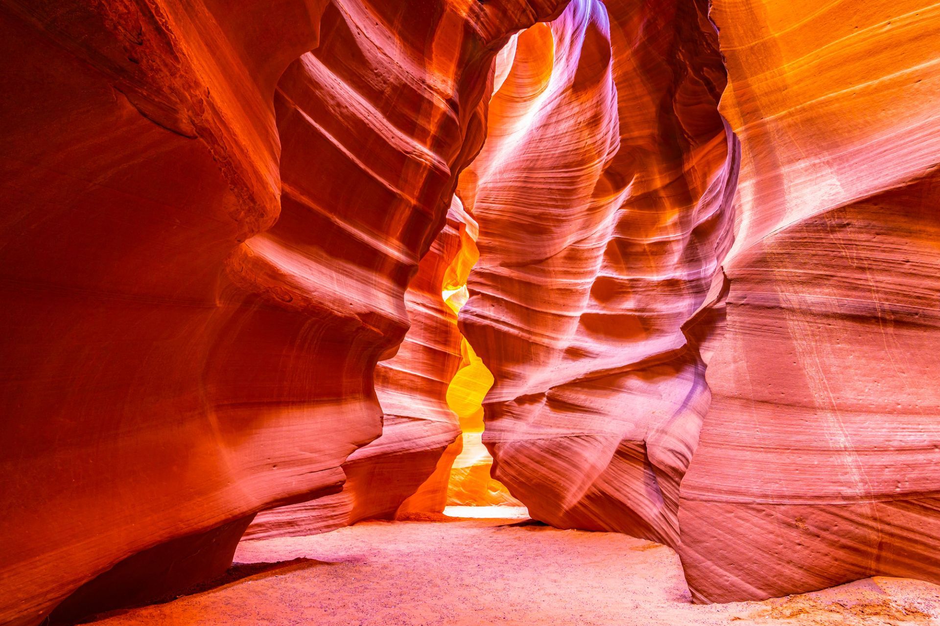
Arizona
## Description Antelope Canyon, on Navajo land near Page, Arizona, is a set of narrow slot canyons carved into Navajo Sandstone by millennia of water and wind erosion. The result is a sequence of sinuous, polished walls that twist into narrow passages, channeling shafts of light into warm, copper-toned swirls that photographers prize. There are two main sections commonly visited: Upper Antelope Canyon (more iconic for vertical light beams in summer) and Lower Antelope Canyon (a more maze-like walk that requires climbing). The interplay of light, shadow and texture transforms the canyon’s interior into a living sculpture that changes with the sun’s angle. Antelope Canyon’s combination of geological finesse and cultural sensitivity makes it unique: it’s on Navajo Nation land and visits occur under Navajo guides who share cultural context and ensure conservation. The ephemeral quality of light in the canyon is the main draw, and every visit offers a subtly different visual story depending on time of day and season. Visiting Antelope Canyon is an intimate, often crowded experience that rewards patience and close observation. The sculpted walls are tactile and close, and the sense of enclosure makes small variations in light and dust dramatically affect composition. Guides routinely manage group flows and timing to optimize safety and photographic opportunity, and many operators now offer specialized photo tours that allow extra time or more flexible tripod policies. Safety is a constant priority — because slot canyons channel water, flash floods are a real hazard and tours may be altered or canceled in the face of storm risk. Respect for Navajo cultural protocols is also essential: guides often include stories and historical context that enrich a visit and reinforce why access is managed. Beyond the two main canyons, nearby attractions around Page — Horseshoe Bend, Lake Powell and Glen Canyon National Recreation Area — make the area a compact cluster of dramatic southwestern landscapes. Combining these sites into a short itinerary can balance the compressed, processed light of the slot canyons with broad, open panoramas of the Colorado River and surrounding desert. ## Location Antelope Canyon lies near Page, Arizona, in the southwestern United States on Navajo Nation land. The canyons are accessed by guided tours departing from Page; bookings are required, and many operators combine Antelope Canyon with nearby attractions like Horseshoe Bend and Lake Powell. Most tours meet in Page; travel to the canyon involves a short drive and, in some cases, a brief ride across Navajo lands to the canyon entrance. Tour operators coordinate closely with park officials and Navajo authorities; book in advance during peak seasons and confirm pickup details. Page has several accommodation options, from campgrounds to hotels, and is a good base for multi-day exploration of the region. ## Tips - **Book Navajo-guided tours:** Access to both Upper and Lower Antelope Canyons is restricted to authorized Navajo guides — book through reputable operators and respect cultural protocols. - **Time your visit for light:** For the classic light beams in Upper Antelope Canyon, mid-day in summer is preferred; other seasons offer softer, diffused light. - **Bring a tripod if allowed:** Some tours permit tripods (often in photo-specific sessions); check operator policies before arrival. - **Be mindful of flash floods:** Slot canyons can be hazardous during heavy rain; guides monitor weather and may cancel tours if flash flood risk exists. - **Protect your gear from sand:** The environment is dusty; use camera covers and clean gear after visits. - **Choose the right tour type:** Standard interpretive tours offer context and safety; photo tours are slower and often allow tripods but require advance booking. - **Expect narrow passages:** Lower Antelope requires more physical movement; wear comfortable clothes and be prepared to climb short ladders or squeeze through tight sections. - **Respect cultural guidance:** Photography of certain features or during ceremonies may be restricted — follow your guide's direction. - **Combine sites for variety:** Pair canyon visits with sunrise at Horseshoe Bend or a boat trip on Lake Powell to round out your visual narrative. ## Conclusion Antelope Canyon is a masterpiece of erosion and light — a place where sandstone artistry and cultural stewardship intersect to create intense photographic and contemplative experiences. Guided visits make it accessible while honoring its Navajo custodianship. Approach Antelope Canyon with curiosity and respect, and you’ll come away with a visceral appreciation for how water, time and human stewardship intersect. For photographers, the canyon is a study in subtle gradients and form; for travelers, it’s an opportunity to learn about the cultural landscape of the Navajo Nation while witnessing an extraordinary geological gallery. ## FAQ - **Q: Which is better, Upper or Lower Antelope Canyon?** - A: Upper is famed for light beams and is more accessible with level walks; Lower is narrower with ladders and a more adventurous feel. - **Q: Do I need a reservation?** - A: Yes — tours sell out, especially in peak season; book in advance. - **Q: Is Antelope Canyon wheelchair accessible?** - A: Accessibility varies: Upper has relatively easier access but still includes uneven surfaces; check specific operator accommodations. - **Q: Can I fly a drone near Antelope Canyon?** - A: Drone use is generally restricted in Navajo lands and near protected sites; check local rules and obtain permission where applicable. - **Q: What are the best months for photography?** - A: Summer delivers the strongest vertical beams around midday; spring and autumn provide softer light and cooler conditions, which many photographers prefer. - **Q: How long does a typical tour last?** - A: Standard canyon tours range from 45 minutes to 1.5 hours including access and return; photo tours may be longer. - **Q: Are there restrictions on clothing or equipment?** - A: Wear closed-toe shoes for lower canyon sections, protect gear from sand, and follow guide instructions for tripods or flash use. ## Links - [Antelope Canyon — Wikipedia](https://en.wikipedia.org/wiki/Antelope_Canyon) - [Navajo Nation Parks & Recreation](https://www.navajonationparks.org)
GemVoyage Team • World
