GemVoyage Team • World
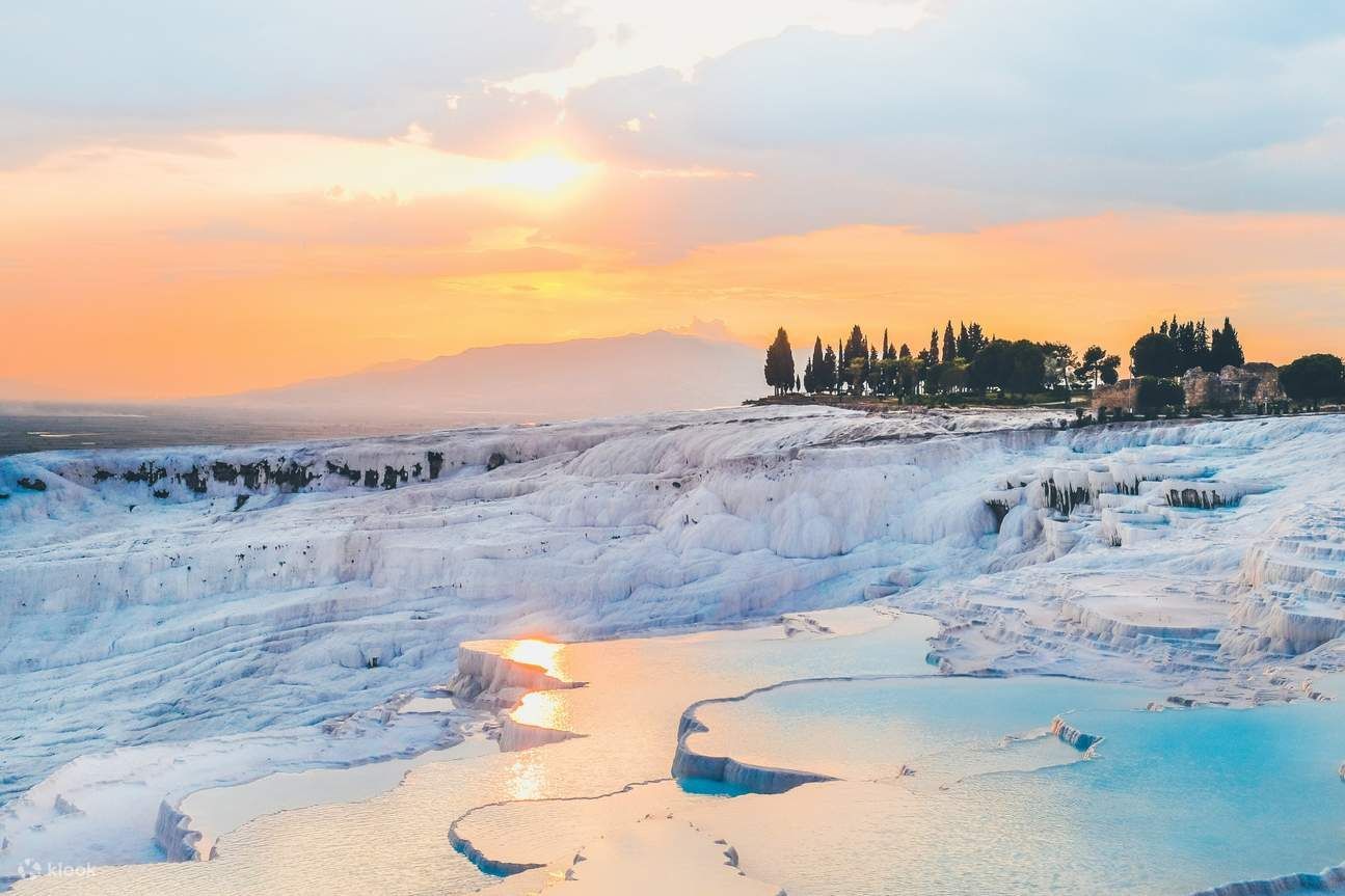
What makes Pamukkale unique is this fusion of geology, thermal waters and preserved ancient architecture: you can soak in warm waters while gazing across white steps that sparkle under the Mediterranean sun and then wander through the atmospheric ruins of a Roman necropolis and theatre. Conservation measures have redirected water flows over the decades to protect fragile formations while allowing controlled access for visitors.
Discover more hidden gems you might love.
Amazonas
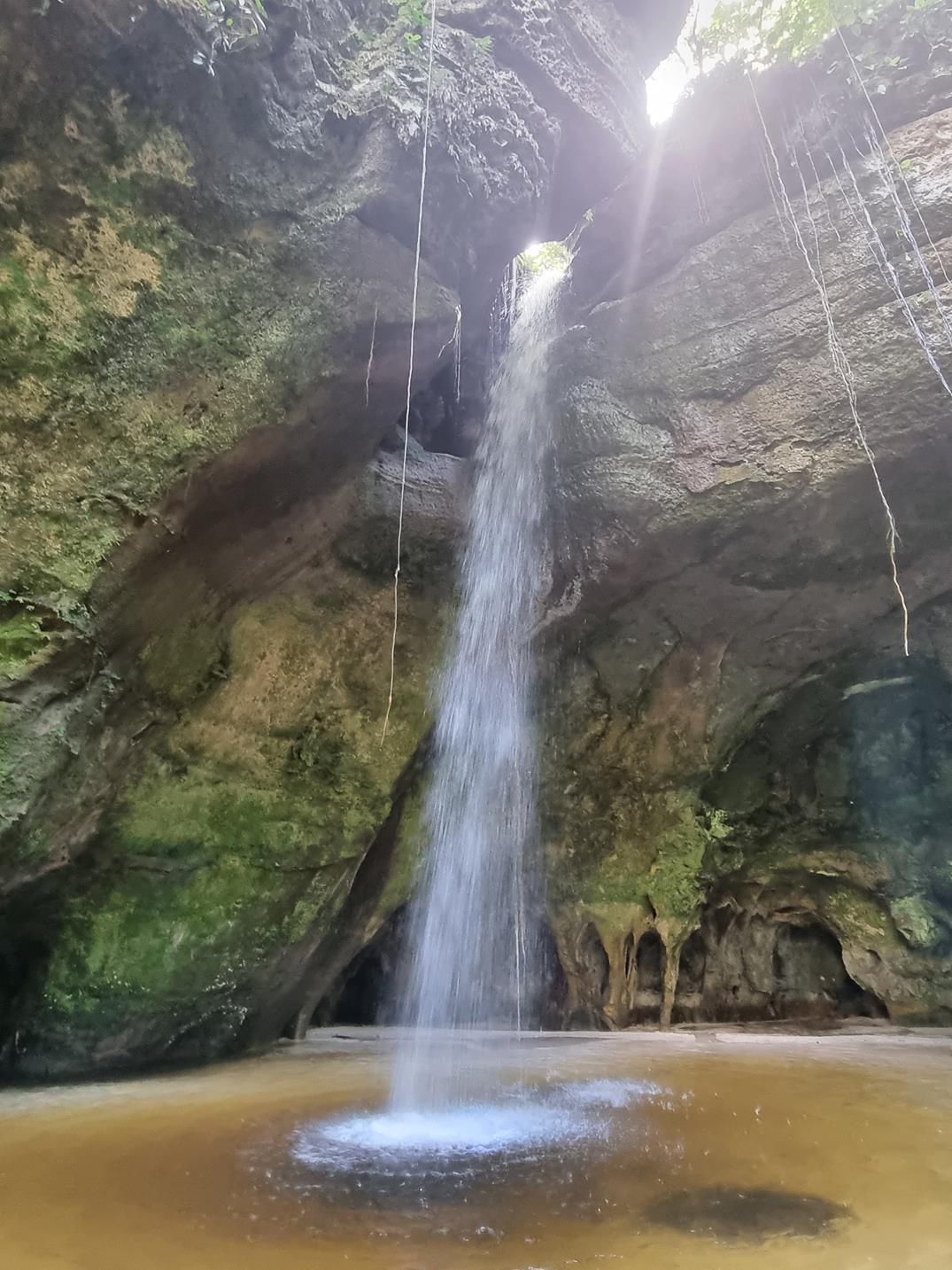
## Description Deep within the lush rainforest of the Amazon lies a pair of natural wonders: **Caverna do Maroaga (Maroaga Cave)** and **Caverna da Judeia (Judeia Cave)**. These caves are part of the Presidente Figueiredo municipality in northern Brazil, often nicknamed the “Land of Waterfalls and Caves” due to its unique geology and landscapes. The **Maroaga Cave** is famous for its dramatic sandstone formations and a stream that flows directly from within, creating a mystical atmosphere as the water emerges from the cave’s dark interior. Sunlight filtering through the forest canopy reflects on the water, giving the cave a magical glow. Its name comes from a local indigenous chief, Maroaga, who is said to have used the cave as a hideout, adding a layer of legend to its natural beauty. The nearby **Judeia Cave** is equally captivating. It features a more intimate setting, with a waterfall cascading over its entrance and forming a natural curtain of water. Walking behind the waterfall offers visitors a unique and refreshing perspective, with the sound of rushing water echoing throughout the cave. A little-known fact is that both caves are part of the same ecological reserve, which shelters a vast variety of flora and fauna. Biologists have recorded rare species of bats and amphibians in these caves, making them not only scenic wonders but also important ecological habitats. ## Location Caverna do Maroaga and Caverna da Judeia are located in **Presidente Figueiredo**, a municipality in the state of **Amazonas**, in northern **Brazil**. The region lies about 107 kilometers north of **Manaus**, the capital of Amazonas, along the BR-174 highway. The most common way to reach the caves is by car or organized tour from Manaus. The drive takes about two hours and passes through dense rainforest landscapes. Once at the entrance to the reserve, guided hikes of varying lengths lead to the caves. The trails are not particularly difficult, but they can be muddy and slippery, especially during the rainy season. For international visitors, the easiest route is to fly into Manaus and then book a day trip or multi-day tour that includes the caves as part of a broader itinerary of waterfalls and natural attractions. ## Tips * **Wear proper footwear:** Hiking boots or sturdy shoes are recommended, as the trails can be wet and uneven. * **Hire a guide:** Local guides not only ensure safety but also provide insights into the caves’ legends, geology, and biodiversity. * **Bring swimwear and a towel:** The waterfalls and streams around the caves are perfect for cooling off after a hike. * **Pack insect repellent:** The Amazon rainforest is home to mosquitoes and other insects, especially near water sources. * **Visit during the dry season:** From June to November, the trails are easier to access, although the rainy season offers stronger waterfalls and a wilder atmosphere. * **Respect the environment:** Avoid leaving litter, and do not disturb the caves’ wildlife, particularly bats and amphibians. ## Conclusion Caverna do Maroaga and Caverna da Judeia showcase the wild beauty and hidden wonders of Brazil’s Amazon rainforest. With their waterfalls, sandstone formations, and legendary history, they are must-visit sites for eco-tourists and adventurers seeking an authentic experience in the heart of nature. Together, they represent not just geological marvels but also living ecosystems that deserve protection and respect. ## FAQ **1. Do I need a guide to visit the caves?** Yes, local guides are highly recommended for safety, navigation, and to ensure the preservation of the natural environment. **2. Can I swim near the caves?** Yes, swimming is allowed in the pools and streams near the caves, but always follow local safety advice. **3. How difficult are the hikes to the caves?** The hikes are moderate in difficulty, with some slippery and uneven sections. Good footwear is essential. **4. Are the caves accessible year-round?** Yes, but the experience differs by season. The rainy season (December–May) offers stronger waterfalls, while the dry season (June–November) makes trails easier to navigate. **5. What wildlife might I see?** Bats, amphibians, tropical birds, and a wide variety of insects inhabit the area. Lucky visitors may even spot monkeys in the surrounding forest. **6. How long should I plan for a visit?** Most tours include both caves in a half-day excursion, though spending a full day allows more time to explore nearby waterfalls and trails. ## Links * [Amazons Wiki](https://en.wikipedia.org/wiki/Amazonas_(Brazilian_state))
GemVoyage Team • World
Kazan
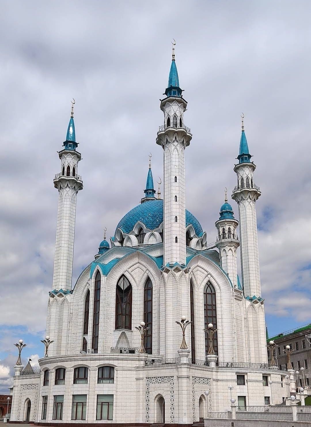
## Description The **Kul Sharif Mosque** is one of the most stunning landmarks in Russia, standing proudly inside the **Kazan Kremlin**. Recognized as both a religious and cultural icon, it represents the rich history of the Tatar people and the peaceful coexistence of different faiths in the region. Its striking blue-and-white minarets, elegant domes, and ornate interiors make it not only a place of worship but also an architectural masterpiece. Originally built in the 16th century, the mosque was destroyed in 1552 during the siege of Kazan by Ivan the Terrible. For centuries, it remained in ruins until it was magnificently rebuilt and reopened in 2005 as part of Kazan’s millennium celebrations. Today, it is one of the largest mosques in Russia and Europe, with the capacity to hold more than **6,000 worshippers**. A fascinating detail is that the mosque is named after **Kul Sharif**, a prominent Tatar religious leader, poet, and defender of Kazan who died during the 1552 siege. Another lesser-known fact is that the mosque’s design blends Islamic and Russian architectural influences, symbolizing Kazan’s unique position as a bridge between East and West. Its interiors are adorned with marble, mosaics, and exquisite chandeliers, while its museum showcases Islamic culture and history. ## Location Kul Sharif Mosque is located in **Kazan**, the capital city of the **Republic of Tatarstan**, within the **Kazan Kremlin**, a UNESCO World Heritage Site. Its central location makes it easily accessible to both locals and tourists exploring the historical heart of the city. To reach Kazan, visitors can fly into **Kazan International Airport**, which has direct flights from Moscow, St. Petersburg, and other major cities. From the airport, the city center is about a 30–40 minute drive. Within Kazan, public transportation is efficient, with buses, trams, and the **Kazan Metro**. The Kremlin, where the mosque is located, can be easily reached by metro (Kremlyovskaya Station) or by taxi. Walking tours are also popular, as the area is rich in cultural and historical landmarks. ## Tips To make the most out of your visit to the Kul Sharif Mosque, consider the following tips: * **Dress modestly** – As an active place of worship, visitors are asked to wear respectful clothing. Women may be provided with scarves if needed. * **Check visiting hours** – The mosque is open to tourists outside prayer times. Always verify the schedule before visiting. * **Explore the museum** – Inside the mosque, you’ll find a small museum dedicated to Islamic culture, manuscripts, and Tatar history. * **Combine with other attractions** – Since the mosque is inside the Kazan Kremlin, you can also visit the Annunciation Cathedral, the Presidential Palace, and the Kremlin walls. * **Enjoy night views** – The mosque is beautifully illuminated after sunset, offering a magical perspective for photography. * **Respect local customs** – Silence and respectful behavior are appreciated inside the prayer halls. ## Conclusion The **Kul Sharif Mosque in Kazan, Russia** is more than just a religious site—it’s a symbol of resilience, cultural pride, and harmony. With its breathtaking architecture, fascinating history, and central location in the Kazan Kremlin, it’s an unmissable attraction for anyone visiting Tatarstan. Whether you’re drawn by faith, history, or design, this mosque offers a truly unforgettable experience. ## FAQ **1. Is the Kul Sharif Mosque still active?** Yes, it functions as both a place of worship and a cultural landmark. Visitors are welcome outside prayer times. **2. Do I need to pay an entrance fee?** Entry to the mosque is generally free, though some museum exhibits inside may require a small fee. **3. How long should I plan for my visit?** Most visitors spend 1–2 hours exploring the mosque and museum, though you may want to set aside more time to enjoy the rest of the Kazan Kremlin. **4. Can non-Muslims enter the mosque?** Yes, the mosque welcomes people of all faiths, as long as visitors respect the dress code and customs. **5. What’s the best time to visit?** Spring and summer offer pleasant weather for exploring the city, while evenings provide the best lighting for photos of the illuminated mosque. **6. Is photography allowed inside the mosque?** Yes, photography is generally allowed, but avoid flash and always respect prayer times. ## Links * [Official Kul Sharif Mosque Website](https://kul-sharif.com) * [Visit Tatarstan – Tourism Information](https://visit-tatarstan.com)
GemVoyage Team • World
Bonn
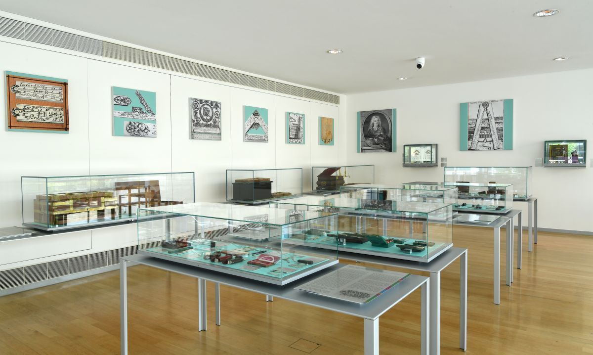
## Description The Arithmeum Museum in Bonn is a highly original museum that turns the history of calculation into a visually engaging and intellectually satisfying visit. Dedicated to the development of arithmetic machines, the museum explores how people have tried to make counting faster, more accurate, and more automated over the centuries. Its collection includes historic calculating devices, elegant mechanical instruments, and exhibits that show how mathematics became part of modern technology. What makes the Arithmeum stand out is that it is both scholarly and accessible. The museum does not expect every visitor to be an expert in mathematics or engineering. Instead, it presents the history of computation through objects, design, and clear narrative structure. That means you can enjoy it whether you are fascinated by mechanical engineering, the history of ideas, or the aesthetic beauty of precision instruments. One lesser-known fact is that the museum is closely associated with academic research on the history of calculation, which gives it an unusually strong intellectual foundation. Another interesting point is that the building’s architecture and presentation style reinforce the idea that mathematics can be elegant as well as practical. The museum is especially rewarding for travelers who like compact museums with a unique theme. It is not overwhelming in scale, but it is memorable because it covers a topic that most people rarely see interpreted so carefully. Visitors often leave with a new appreciation for the long path from abacus and slide rule to digital computation. Even those who do not think of themselves as “math people” usually find something in the collection that captures their attention, whether it is an ornate machine, a clever mechanism, or the logic behind a technological breakthrough. ## Location Arithmeum is located in Bonn, North Rhine-Westphalia, Germany, in the city’s central academic and cultural area. Bonn itself is easy to navigate, and the museum’s position makes it a practical stop during a day of exploring the old federal city. The best way to get there is by local public transport or on foot if you are staying in the center. Bonn’s compact layout makes walking convenient, especially if you are combining the museum with other nearby institutions or university-related sites. If you are arriving from farther away, regional trains and the city’s transit network provide straightforward access to central Bonn. ## Tips Read the display labels carefully, because the story behind each object often matters as much as the object itself. This is a great museum for rainy days or for travelers who want an indoor cultural stop between larger city visits. If you enjoy design, pay attention to the museum’s architecture and how the exhibition spaces guide the flow of the visit. Families with older children and teens may find it especially interesting if they enjoy puzzles, mechanisms, or STEM topics. Pair the visit with other Bonn sights to make the most of your time in the city. ## Conclusion Arithmeum is a thoughtful and elegant museum that turns the history of calculation into a memorable cultural experience in Bonn. ## FAQ ### What is the Arithmeum about? It focuses on the history of arithmetic, calculating machines, and the development of computation. ### Is it only for mathematicians? No. The museum is accessible to general visitors, design lovers, and anyone curious about technology history. ### How long does a visit take? Most visitors spend around one to two hours. ### Is it close to other Bonn attractions? Yes. Its central location makes it easy to combine with other museums and historic sites. ### Why is it considered unique? Because it treats a technical subject with strong visual design and clear storytelling. ## Links - [Official website](https://www.arithmeum.uni-bonn.de/) - [Arithmeum on Wikipedia](https://en.wikipedia.org/wiki/Arithmeum)
GemVoyage Team • World
Gansu
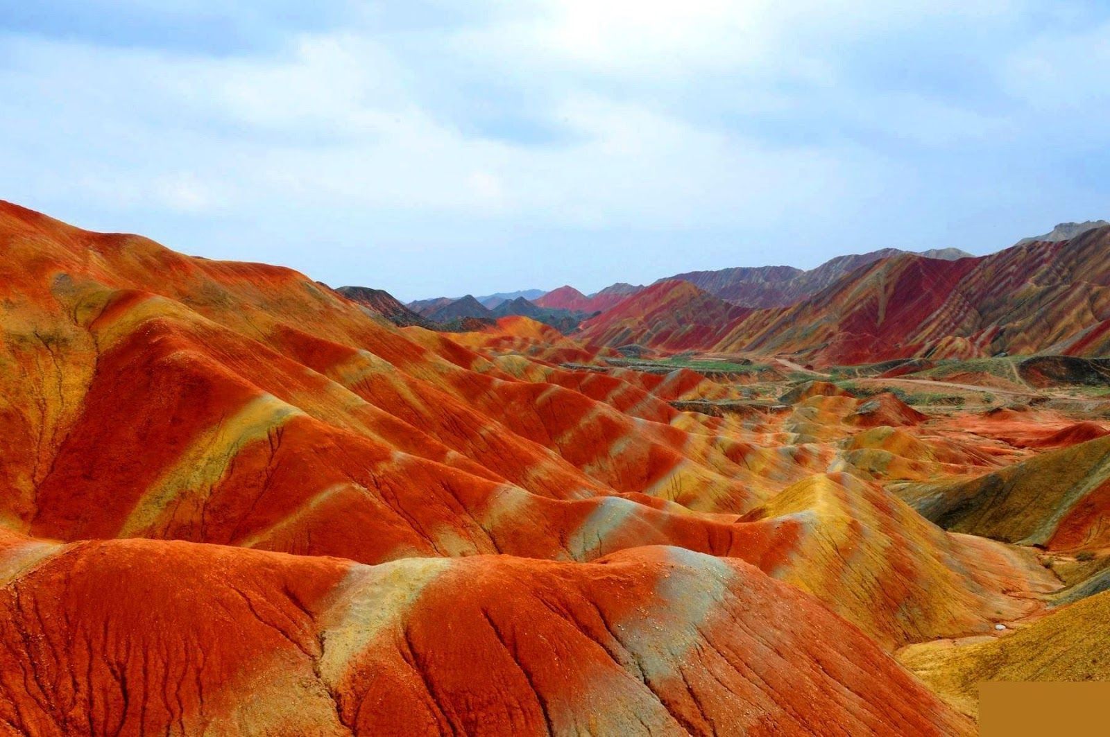
## Description The Zhangye Danxia landform in Gansu province is a riot of color spread across layered sandstone ridges and steep cliffs, creating landscapes that look as if someone painted the earth with broad strokes of red, orange, yellow and green. The chromatic bands are the product of red sandstone and mineral deposits laid down over 24 million years and later uplifted and carved by wind and water. Viewed from purpose-built overlooks and winding boardwalks, the patterns create optical illusions of waves and folds that shift with the sun’s angle. The site is remarkable both for its vivid palette and for the scale of the striations: what from a distance seems like painted canvas resolves into a labyrinth of ridges, gullies and panoramic terraces. A lesser-known detail: the colors vary seasonally and with weather conditions; after rain, the hues often deepen, offering particularly saturated photographic opportunities. Beyond the immediate visual drama, Zhangye Danxia offers a lesson in geologic time and human-scale interpretation of landscape. The park's boardwalks and viewing platforms were designed to give visitors a range of compositions at different elevations, while interpretive signs explain the processes of sedimentation, uplift and erosion that produced the striking bands. Photographers and landscape enthusiasts often plan their visits around atmospheric conditions: low-angle light during golden hours casts ridges into sharp relief, while overcast or misty days can soften colors and emphasize shapes. The park's scale means that a single viewpoint never fully captures the variety present across the terrain — taking time to traverse multiple platforms yields a richer sense of the formations. Local infrastructure has expanded to accommodate steady tourism, but many visitors still find quiet corners along lesser-known paths. For those willing to explore beyond the main viewing decks, short hikes and rural lanes reveal unexpected perspectives of the painted cliffs and provide a quieter atmosphere for contemplative study. The town of Zhangye offers practical amenities including hotels, train connections and guided-tour services; most visitors access the geopark via a short drive from the city. When combined with nearby attractions in Gansu province — historic Silk Road sites, oasis towns and desert landscapes — Zhangye Danxia becomes a vivid and contrasting chapter in any northwest China itinerary. ## Location The Zhangye Danxia Geopark lies in Zhangye city, Gansu province, northwestern China. It’s accessible by road from Zhangye city center, which in turn connects by train or air to larger Chinese hubs such as Lanzhou and Xi’an. The park’s viewing platforms are designed for staged sightseeing, enabling visitors to experience different panoramas without extensive trekking. Timetables for trains and regional buses vary seasonally; many travelers arrive by high-speed or conventional rail to Zhangye and then take local shuttle services or taxis to the geopark entrance. The park's layout is linear, with a series of parking lots and platforms that correspond to different photographic viewpoints — plan logistics to avoid backtracking during peak hours. Accommodation in Zhangye ranges from economical guesthouses to mid-range hotels that can arrange guided excursions and private transport. ## Tips - **Visit at golden hour:** Sunrise or sunset gives the painted ridges warmer tones and dramatic shadows. - **Use multiple viewpoints:** Walk the main boardwalk and visit several overlooks to appreciate how the formations change with perspective. - **Protect from dust and sun:** The region is arid; bring sun protection and a dust cover for camera gear. - **Consider guided photo tours:** Local guides can take you to lesser-known vantage points for unique compositions. - **Time your transport:** Parking and shuttle flows can be busy; arrive early to avoid crowds at the main platforms. - **Dress for desert conditions:** Layered clothing, sturdy shoes and water are essential; evenings can cool significantly. - **Respect park rules:** Stay on boardwalks to protect fragile soils and prevent erosion; drones are often restricted. - **Bring varied lenses:** A wide-angle to capture panoramic ridgelines and a moderate telephoto to isolate patterns will be useful. ## Conclusion Zhangye Danxia offers one of the planet’s most vivid examples of sedimentary color and erosion, a landscape that rewards patient observation and thoughtful composition. Visiting Zhangye Danxia is as much an exercise in perception as it is in travel logistics — the colors and forms change with light, season and vantage point, and the most memorable experiences come when you slow down and let the terrain reveal its subtleties. For photographers, geologists and curious travelers, the geopark is a compelling and photogenic stop that pairs well with broader exploration of Gansu’s cultural and natural history. ## FAQ - **Q: Is the park walkable?** - A: Yes — well-maintained boardwalks and viewing platforms offer accessible scenic routes. - **Q: Can I drive between viewpoints?** - A: Internal park transport and short walks connect main viewpoints; check park maps for distances. - **Q: When is the best season for color saturation?** - A: Late spring through early autumn generally provides strong color contrast, but early morning light and post-rain conditions often produce the most saturated hues. - **Q: Are drones allowed for aerial photography?** - A: Drone policies vary and are often restricted near protected viewpoints — always check park regulations and obtain permits if required. - **Q: How much time should I allocate?** - A: A full half-day can cover the primary platforms; photographers might want a full day to cycle through light conditions and multiple viewpoints. - **Q: What other nearby sites pair well with Zhangye Danxia?** - A: Historic Silk Road towns, the Mati Temple Grottoes and desert landscapes around Zhangye make for complementary cultural and geological explorations. ## Links - [Zhangye Danxia — Wikipedia](https://en.wikipedia.org/wiki/Zhangye_National_Geopark)
GemVoyage Team • World
Tokyo
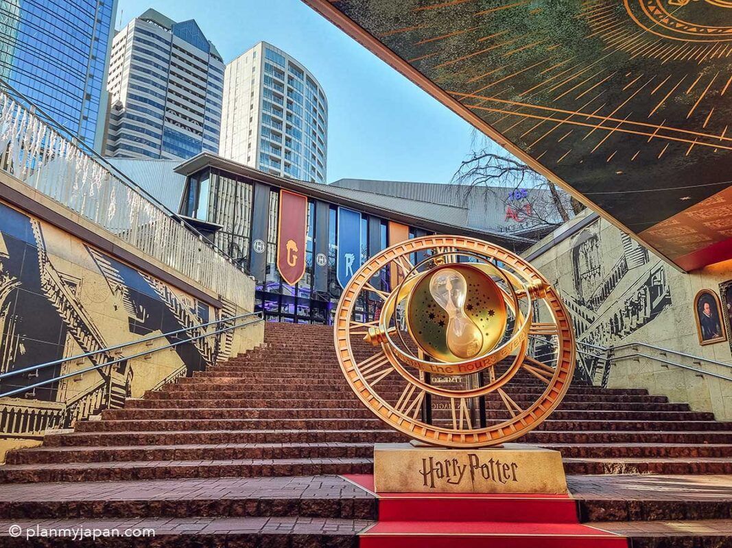
## Description The **Harry Potter Stairs & Time Turner (ハリー・ポッター階段とタイムターナー)** in Tokyo is one of the city’s most popular **pop-culture photo landmarks**, blending cinematic fantasy with modern urban design. This attraction is not a historical monument or a traditional museum—it is a **themed visual installation inspired by the Harry Potter film series**, designed specifically for fans who want to step inside the wizarding world without leaving central Tokyo. The installation recreates two of the most iconic visual elements from the films: the **magical moving staircase of Hogwarts** and **Hermione Granger’s Time Turner** from *Harry Potter and the Prisoner of Azkaban*. The staircase evokes the illusion of shifting directions and hidden passages, while the oversized Time Turner sculpture serves as a symbolic centerpiece representing time travel, destiny, and choice—core themes in the Potter universe. What makes this location truly unique is that it exists **inside a contemporary commercial complex rather than a theme park**. This means visitors do not need to buy expensive tickets or travel to a resort location to enjoy an immersive Harry Potter-themed environment. The installation uses **cinematic lighting, reflective metallic surfaces, stone textures, and enchanted-style typography** to create a convincing atmosphere of fantasy within a very modern architectural setting. The stairs are often used as a **staged photo zone**, where visitors recreate scenes, cosplay as characters, or simulate stepping into a time-loop narrative. The Time Turner sculpture is particularly photogenic when illuminated in the evening, when its rotating rings and glowing accents transform the space into a dramatic visual set piece. Many visitors describe the experience as feeling like walking into a **film trailer set inside a shopping mall**—brief, stylized, and designed for visual impact rather than storytelling depth. A little-known fact is that the stairs and Time Turner installation were part of a **long-term promotional collaboration connected to Warner Bros. Japan and official Harry Potter licensing projects**, timed to coincide with renewed franchise activity in Tokyo. Another lesser-known detail is that the space is frequently **updated with seasonal lighting themes and limited-time character visuals**, which means repeat visits can feel subtly different across the year. Importantly, this site is not meant to replace **The Making of Harry Potter Studio Tour Tokyo**; rather, it acts as a **public teaser-style landmark**, accessible to anyone passing through the district. It attracts an extremely diverse crowd: international tourists, Japanese fans, casual shoppers, cosplayers, couples, and social-media creators all intersect in the same space. The emotional appeal of the installation lies in its ability to deliver **instant recognition and nostalgia**. Even a short visit—often no more than 10 to 15 minutes—can trigger powerful emotional connections for fans who grew up with the books and films. It is, at its core, not a storytelling space but a **symbolic photo experience**, built for visual memory rather than narrative immersion. ## Location The **Harry Potter Stairs & Time Turner** installation is located in **central Tokyo**, inside a major commercial complex in the **Akasaka / Roppongi area**, which has become a hub for large-scale themed entertainment projects. **City:** Tokyo **Region:** Kantō **Country:** Japan **District:** Minato Ward (Akasaka / Roppongi area) ### How to Get There: * **By Tokyo Metro:** * **Chiyoda Line** to **Akasaka Station** * **Hibiya Line or Toei Oedo Line** to **Roppongi Station** * **By JR Train:** Use JR lines to nearby hubs such as **Shinjuku or Tokyo Station**, then transfer to the metro. * **By taxi:** Easy and accurate if you show the Japanese attraction name. * **On foot:** The area is highly walkable and well-connected through underground passages and plazas. The installation is typically integrated into a **shopping, dining, and entertainment complex**, making it easy to combine with cafés, retail stores, and evening nightlife. ## Tips * **Visit in the evening:** The lighting effects are significantly more dramatic after sunset. * **Go on weekdays for clearer photos:** Weekends often bring long lines of people waiting for their turn. * **Bring a small tripod if allowed:** For steady night photos, especially around the Time Turner. * **Do not expect a full “attraction experience”:** This is a **visual installation**, not a ride or museum. * **Cosplay is common:** Light cosplay is generally accepted and often encouraged by visitors. * **Respect queue etiquette:** Japanese photo spots usually operate with informal but strict order. * **Combine with nearby Harry Potter experiences:** If you are a serious fan, this pairs well with the Studio Tour Tokyo. * **Check for seasonal updates:** Lighting schemes and banners occasionally change. ## Conclusion The **Harry Potter Stairs & Time Turner in Tokyo** is a compact yet powerful example of how modern cities translate cinematic fantasy into everyday urban space. It is not a destination for long exploration, but a **precise, visually engineered moment of nostalgia**, crafted for fans who want a tangible connection to the wizarding world without committing an entire day to a theme park. For Harry Potter enthusiasts, it delivers something precise and valuable: **a magical pause inside the rhythm of real city life**. ## FAQ **1. Is the Harry Potter Stairs & Time Turner a real theme park attraction?** No. It is a **public visual installation**, not a ride or ticketed experience. **2. Is it free to visit?** Yes. Access is **free**, as it is located inside a public commercial complex. **3. How long does a visit typically take?** Most visitors spend **10 to 20 minutes**, depending on photo queues. **4. Is it suitable for children?** Yes. It is **family-friendly**, though it can get crowded. **5. Is this the same as the Harry Potter Studio Tour Tokyo?** No. This is a **small themed photo landmark**, whereas the studio tour is a full museum-style experience. **6. Can I take professional photos there?** Casual photography is allowed. **Commercial shoots may require permission** from the property management. ## Links * [Warner Bros. Japan](https://www.warnerbros.co.jp) * [Harry Potter Studio Tour Tokyo](https://www.wbstudiotour.jp)
GemVoyage Team • World
Utena County
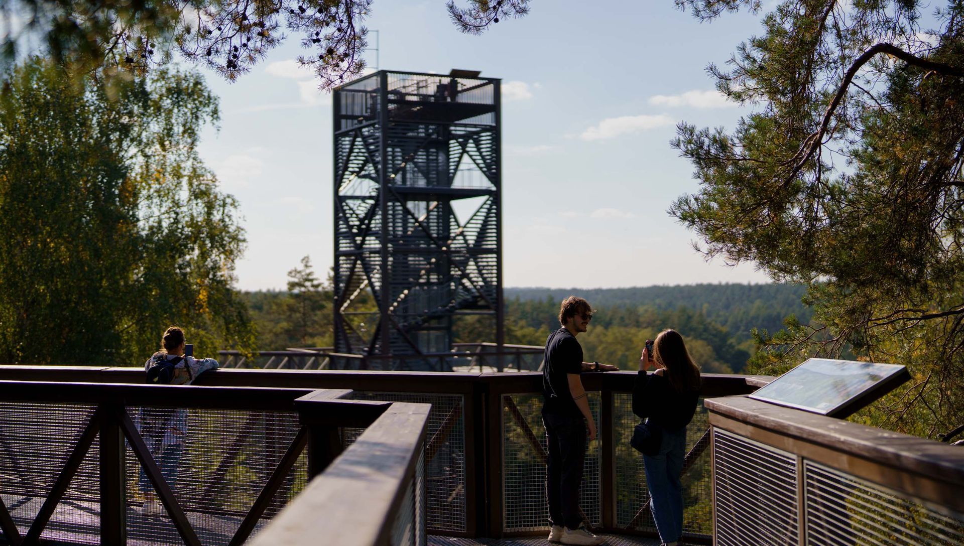
## Description The Anykščiai Treetop Walking Path is an elevated walkway that lifts visitors into the forest canopy near the town of Anykščiai, providing rare, treetop-level perspectives over pine and spruce stands and the winding valley of the Šventoji River. Running across a series of boardwalks and culminating in an observation tower, the path reveals forest structure, understory dynamics, and panoramic views that are otherwise hidden from ground level. What distinguishes this attraction is its combination of accessibility, interpretive design, and conservation-minded construction. The path’s elevated platforms and carefully designed supports minimize soil compaction and root disturbance, protecting vulnerable plant communities below. Along the walkway, interpretive panels introduce visitors to forest ecology, native species, the role of wetlands, and regional conservation initiatives. The experience is both sensory and educational: the canopy’s light, wind, and birdlife offer memorable immersion, while the tower’s panoramic platform rewards visitors with far-reaching vistas of the Šventoji River valley. The path was created with families and broad accessibility in mind—gentle gradients, safety railings, and wide decks make it suitable for many visitors, although final accessibility varies across specific sections. The project reflects a deliberate effort to balance public access, education, and nature protection, making it a model for low-impact environmental tourism. ## Location The Anykščiai Treetop Walking Path is situated near the town of Anykščiai in Utena County, northeastern Lithuania, an area celebrated for its literary history and distinctive wooden architecture. The site is accessible from Vilnius and Kaunas by regional bus services to Anykščiai; local shuttles or taxis can bring visitors the short distance to the trailhead. On-site parking is available during visiting hours, and the town provides dining and accommodation options for longer stays. ## Tips - **Assess height comfort:** The elevated platforms are safe but may be challenging for those with acute fear of heights. Move at your own pace and use railings. - **Bring optics and cameras:** Binoculars and cameras enhance birdwatching and landscape photography from the tower and platforms. - **Visit in warm months:** Late spring through early autumn offers full foliage, active birdlife, and accessible boardwalks; check seasonal opening times for winter closures. - **Dress for the outdoors:** Wear comfortable walking shoes and layered clothing; the canopy can be cooler and windier than the forest floor. - **Combine with Anykščiai cultural sites:** Pair the treetop walk with a visit to the town’s literary museums and wooden architecture for a blended nature-and-culture day. ## Conclusion The Anykščiai Treetop Walking Path is an accessible, interpretive experience that invites visitors to discover forest ecology from a new vantage point. It combines low-impact design, educational materials, and dramatic views—ideal for families, school groups, and nature enthusiasts interested in immersive environmental learning. ## FAQ - **Q: Is the Anykščiai treetop path suitable for wheelchairs or strollers?** A: Some sections are designed to be accessible, but full accessibility can vary—contact the site in advance for details on ramps and platform access. - **Q: How much time should I plan for a visit?** A: Plan 1–2 hours to walk the path, ascend the observation tower, and read interpretive panels; longer if you want to picnic or birdwatch. - **Q: Is there an entrance fee or opening season?** A: Many treetop paths charge a modest fee and operate seasonally—confirm current hours and rates on the official site or local tourist information. - **Q: Are dogs allowed on the treetop path?** A: Policy varies; some paths allow well-controlled dogs on short leashes while others restrict pets to protect wildlife—check rules before bringing pets. - **Q: Can the path be used for school or group education?** A: Yes—interpretive panels and safe design make it ideal for school groups; contact local organizers to arrange guided programs or group rates. - **Q: Is the path safe in wet weather?** A: Walkways can be slippery when wet—use caution and appropriate footwear. Some sections may be closed during severe weather for safety. ## Links -- [Hike Information](https://saugoma.lt/en/objects/objects-the-treetop-walking-path)
GemVoyage Team • World

Comments