Discover extraordinary places shared by our community of travelers
Siena
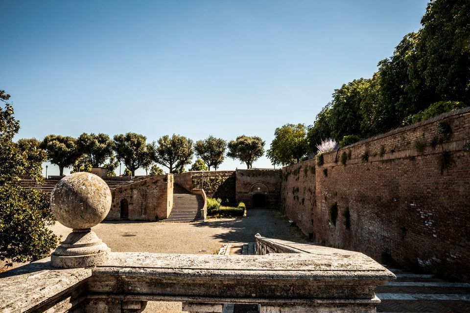
## Description Fortezza Medicea is one of Siena's most imposing landmarks because it represents a different historical layer from the city's medieval churches and squares. Built after Siena's defeat by Florence, the fortress reflects Medici power and the political reshaping of the region during the Renaissance. Unlike a decorative palace or a purely ceremonial monument, it was designed for strategic control and military presence. Today, however, it functions as a public space where history, viewpoints, and local life meet in a surprisingly relaxed way. The fortress is memorable because of its scale and shape. Its bastioned walls form a strong geometric presence above the city, and the elevated position gives visitors sweeping views over Siena and the surrounding Tuscan landscape. That combination of fortification and panorama makes it especially rewarding for travelers who appreciate places where architecture tells a political story. The walls are not just old stone; they are evidence of conquest, rule, and the reshaping of urban space. One little-known fact is that the fortress became less about defense over time and more about civic and cultural use, showing how military architecture can be repurposed for public life. Another detail many visitors miss is how the fortress helps explain the relationship between Siena and Florence. It is not just a monument standing above the city but a reminder of an era when regional power was expressed through earthworks, bastions, and visible control of the landscape. Visitors often appreciate the fortress for its calm atmosphere. While the city center of Siena can be bustling with tourists, the Fortezza Medicea feels more open and spacious. It is a good place to pause, look out across rooftops and hills, and understand how Siena sits within the broader Tuscan setting. If you are interested in military history, urban viewpoints, or Renaissance politics, the fortress is one of the city's most significant stops. ## Location Fortezza Medicea is in Siena, in Tuscany, Italy, just north of the historic center and within walking distance of major city attractions. Because it sits on elevated ground near the old core, it is easy to include in a walking tour of Siena, though the approach may involve some uphill sections depending on your starting point. If you are coming from Piazza del Campo or the cathedral area, the walk to the fortress is straightforward and can be done on foot. Buses and taxis can take you close as well, but walking is usually the best option because it lets you experience the transition from Siena's dense medieval streets to the more open fortified landscape. The most practical recommendation is to visit it while exploring Siena on foot, especially if you want to combine the fortress with other panoramic stops. Because the site is open and spacious, it works well as a late-afternoon or early-evening destination when the light becomes softer. ## Tips Go for the views as much as for the history. The fortress gives some of the best panoramas in Siena, so bring time to linger and not just pass through. If possible, combine the fortress with a walk through the surrounding park-like areas and nearby city streets. That allows you to see how the fortress integrates into Siena's urban edge rather than treating it as a disconnected monument. Read a little about the Medici and the political history of Siena before your visit. Knowing why the fortress was built changes the experience from a simple architectural stop into a clearer story about conquest and control. Visit on a day with good visibility if scenic views matter to you. The fortress is enjoyable in many conditions, but its strongest appeal is the way it frames the city and countryside. ## Conclusion Fortezza Medicea is one of Siena's most powerful historical sites, combining Renaissance military architecture, city views, and a reminder of the region's complex political past. ## FAQ ### Why was Fortezza Medicea built? It was built as a military fortress after Siena came under Medici control, serving as a symbol of political power and strategic dominance. ### Is the fortress open to visitors? Yes, the grounds and surrounding areas are generally accessible, though specific use may vary over time. ### What is the best part of visiting the fortress? The best part is the combination of panoramic views and the chance to understand Siena's political history. ### How long should I spend there? Most visitors spend between 30 minutes and an hour, depending on how much time they want for walking and views. ## Links - [Siena tourism](https://www.visitsiena.it/en/)
GemVoyage Team • World
Lille
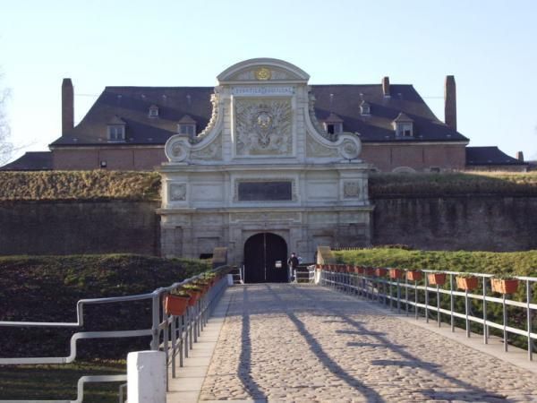
## Description The Citadel of Lille is one of the most impressive military structures in France and a major reason the city is often mentioned in discussions of European fortress design. Built in the 17th century under the direction of Vauban, the citadel is a star-shaped defensive complex that demonstrates both engineering precision and political ambition. It was intended to protect Lille after the city came under French control, and today it stands as a reminder of how military architecture could also shape a city's identity and landscape. What makes the citadel special is that it is not only technically significant but also visually elegant. Its geometric form, wide moats, robust bastions, and open green surroundings make it feel like a fortress designed by someone who understood both defense and urban order. Even if you are not deeply interested in military history, the citadel is compelling because of how it connects architecture, public space, and the natural environment. It is both a monument and a park-like setting, which gives it a very different feeling from densely built old-town landmarks. One little-known fact is that the Citadel of Lille is sometimes referred to as the "queen of citadels" because of its importance in Vauban's defensive system. Another detail many visitors miss is how well the structure fits into the modern city. Although originally conceived for warfare, the citadel now helps define a recreational and cultural zone where walking, cycling, family outings, and visits to nearby attractions all take place. That transformation from military stronghold to civic landmark is part of what makes the site interesting today. The citadel also helps visitors understand Lille's broader history. The city sat near contested borders for centuries, so fortifications were more than symbolic; they were necessary tools of survival and control. Standing at the citadel, you can sense the strategic value of the location and see how a military engineer like Vauban thought about terrain, sightlines, and access. For architecture lovers, history enthusiasts, and casual walkers alike, it is one of Lille's most rewarding destinations. ## Location The Citadel of Lille is in Lille, in the Hauts-de-France region of France, west of the historic center near the Deûle River and surrounding parkland. Its location makes it easy to combine with a broader exploration of Lille's old quarters, especially if you are already spending time around the city center. Unlike a fortress in a remote military zone, this citadel sits comfortably within the urban fabric while still feeling spacious. Getting there is simple by foot, bicycle, or local transport. If you are staying in central Lille, a walk to the citadel is pleasant and reveals how the city's layout changes as you move from dense streets to more open green space. Buses and taxis can also bring you close, but many visitors prefer to use the approach as part of a longer stroll. Because the citadel is surrounded by parks and walking routes, it works especially well as part of a relaxed day outdoors. You can combine it with the nearby zoo, river paths, or other west-side attractions if you want to make the most of the area. ## Tips Allow time for the surroundings as well as the fortress itself. The citadel's setting in parkland is one of its greatest strengths, and the experience improves when you treat it as part of a broader walk rather than a quick photo stop. If you are interested in military history, read a little about Vauban before visiting. His work shaped many French fortifications, and understanding his methods makes the citadel much more meaningful. Visit in good weather if you want to enjoy the outdoor environment fully. The site is enjoyable year-round, but clear conditions make the geometry and scale easier to appreciate. Bring comfortable shoes or use a bicycle if you plan to cover more of the surrounding area. The citadel fits naturally into an active day in Lille and is especially pleasant for travelers who enjoy a mix of history and open-air walking. ## Conclusion The Citadel of Lille is a landmark of French military architecture and a beautiful place to understand the strategic history of the city while enjoying one of its most open and pleasant landscapes. ## FAQ ### Who built the Citadel of Lille? It was designed by Vauban, the famous French military engineer, in the 17th century. ### Why is the citadel important? It is important because it is one of the best examples of Vauban's fortification work and a key part of Lille's historical defense. ### Can you visit the citadel today? Yes. The area is accessible and widely used for walking and recreation, though access may vary in specific sections. ### Is it close to Lille's city center? Yes. It is located west of the center and is easy to reach on foot or by local transport. ## Links - [Lille tourism](https://www.lilletourism.com/) - [Wikipedia article](https://en.wikipedia.org/wiki/Citadel_of_Lille)
GemVoyage Team • World
Seville
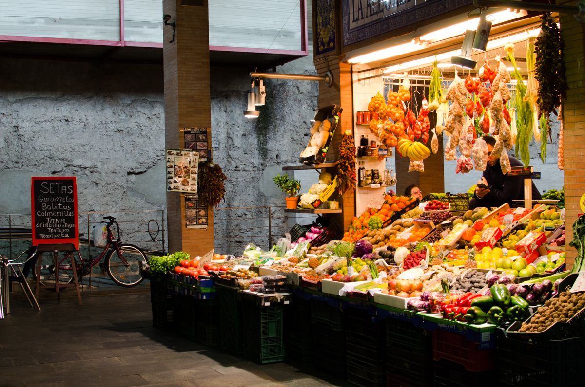
## Description Triana Market is one of the most characterful places to experience everyday Seville beyond the postcard version of the city. Set in the Triana neighborhood, it combines the energy of a traditional neighborhood market with the atmosphere of a place shaped by river life, ceramics, flamenco, and strong local identity. Visitors come here for produce, but they often stay longer because the market feels like a living introduction to the district itself. It is not a polished tourist stage. It is a working market where stallholders greet regulars, chefs shop for ingredients, and curious travelers can see how Seville still feeds itself in a very local way. What makes Triana Market especially appealing is the balance between food and history. The market sits close to the Guadalquivir River and near the area where Triana’s old artisan traditions developed, so a visit naturally turns into a wider walk through one of Seville’s most distinctive quarters. You can browse fruit, fish, meat, olives, pastries, spices, and tapas-style snacks while hearing the rhythm of a neighborhood that has long been associated with sailors, potters, and performers. A little-known detail is that the market stands near archaeological remains tied to the former Castle of San Jorge, which adds a historical layer that many visitors miss when they come only for lunch. Another less obvious fact is that the market is often the place where locals go to buy ingredients for home cooking rather than a destination designed mainly for tourists, which is part of why it feels authentic. The best experience here is not rushed. Start by looking around rather than ordering immediately, because the market rewards observation. The colors of the fruit stalls, the smell of fried food, the chatter from the bars, and the pace of local shopping all help explain why Triana is one of Seville’s most beloved neighborhoods. If you are interested in local culture, this is also an excellent point of departure for exploring ceramics shops, riverfront views, and the streets around Calle Betis and the Triana Bridge. ## Location Triana Market is in the Triana neighborhood on the west bank of the Guadalquivir River in Seville, Andalusia, Spain. The neighborhood sits just across the river from the historic center, so the market is easy to include in a day of sightseeing. If you are already in central Seville, the simplest approach is to walk across the Triana Bridge and continue into the market area on foot. That route is especially enjoyable because it gives you a clear sense of how the city changes from the monument-filled center to the more residential and traditionally working-class Triana side. If you are coming from farther away, a taxi, city bus, or a combination of walking and public transport will work well. The market is compact, so once you arrive, you will not need additional transport. It also pairs naturally with nearby river walks, ceramic workshops, and tapas stops, which makes it a practical base rather than a standalone quick stop. In hot weather, plan your arrival earlier in the day, since the surrounding streets can become warm by midday and the market itself is more enjoyable before the lunch rush. ## Tips - Go in the morning if you want the fullest market atmosphere and the best selection of produce and seafood. - Bring both cash and a card, because some smaller stalls prefer one or the other. - Do not limit yourself to shopping; the bars inside and around the market are part of the experience. - Combine the visit with a walk through Triana’s ceramic streets and the riverfront. - If you want photos, arrive early enough to avoid the busiest lunch crowd. - Ask stallholders what is in season, since that is often the fastest way to taste the most local products. ## Conclusion Triana Market is one of the most rewarding places in Seville for travelers who want local flavor, neighborhood character, and a real sense of daily life. It is easy to reach, rich in atmosphere, and memorable well beyond a simple shopping stop. ## FAQ ### Is Triana Market worth visiting even if I am not cooking? Yes. The market is worth visiting for its atmosphere, food counters, and neighborhood character even if you do not plan to buy ingredients. ### What is the best time to visit Triana Market? Morning is usually best, especially if you want fresh produce and a calmer pace before the lunch rush begins. ### Can I eat inside or near the market? Yes. The market and the surrounding streets have bars and food counters where you can eat casually and try local dishes. ### How long should I spend there? Plan at least one hour, and more if you want to combine shopping, snacks, and a walk through the neighborhood. ## Links - [Wikipedia](https://en.wikipedia.org/wiki/Triana,_Seville) - [Seville tourism information](https://www.visitasevilla.es/en)
GemVoyage Team • World
Victoria
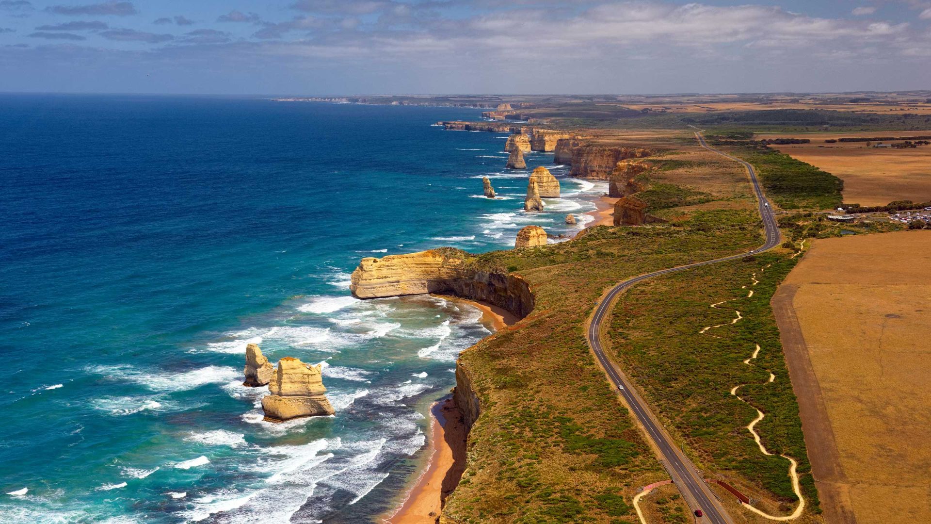
## Description The Great Ocean Road is one of the world’s most celebrated coastal drives, winding along Victoria’s southwestern shoreline past rugged cliffs, surf beaches and sculpted limestone stacks such as the Twelve Apostles. Built by returned WWI soldiers and dedicated as a war memorial, the road combines engineering, natural wonders and seaside towns with cafes, galleries and surf culture. Dramatic viewpoints, rainforest gorges (like Great Otway National Park) and wildlife sightings (koalas, kangaroos and seabirds) make the route a versatile exploration corridor. What distinguishes the route is its dramatic juxtaposition of surf, limestone geology and accessible townscapes. Photographers and road trippers prize the series of staged viewpoints where walking tracks descend to coves and panoramic platforms look out to offshore stacks. Beyond the famous stacks, the route offers fern gullies and waterfalls in the Otways, coastal walks to hidden beaches, and small towns where food and surf culture combine. Many travelers craft multi-day itineraries that combine coastal hikes, wildlife spotting and culinary stops, from coffee in Torquay to seafood in Apollo Bay and heritage-listed lookouts around Port Campbell. The road’s memorial origins also allow visitors to reflect on the engineering feat and the region’s social history while enjoying one of Australia’s most scenic drives. ## Location The Great Ocean Road runs from Torquay to Allansford near Warrnambool in Victoria, Australia, with key stops including Anglesea, Lorne, Apollo Bay and the Twelve Apostles viewpoint at Port Campbell. Melbourne is the primary gateway, roughly a 1.5–3 hour drive to the start depending on traffic. ## Tips - **Avoid peak holiday traffic and plan overnight stops:** The route is popular during Australian school holidays; split the drive into staged stops to avoid fatigue and to enjoy hikes. - **Plan time for short walks and lookout detours:** Many of the best views require small detours and short walks; factor these into your itinerary rather than only driving. - **Mind driving conditions and seasonal weather:** Wind, sea spray and rain can change conditions quickly — watch for strong crosswinds and take care on narrow coastal roads. - **Book accommodation and tours in advance during peak season:** Lorne, Apollo Bay and Port Campbell fill quickly in summer — reserve ahead if travel dates are fixed. - **Pack layers and photography gear:** Coastal light changes quickly; bring windproof layers, a tripod for sunrise/sunset shots and protective gear for salt spray. ## Conclusion The Great Ocean Road pairs dramatic coastal geology with accessible townscapes and outdoor experiences, making it an essential Australian road trip for nature lovers and photographers. Thoughtful pacing and an eye for sidetracks reveal quieter coves, rainforest secrets and local food scenes that complement the iconic seascapes. ## FAQ - **Q: How long does the full drive along the Great Ocean Road take?** A: The direct driving time without stops is around 6–7 hours, but most travelers allocate 2–3 days to properly enjoy walks, viewpoints and coastal towns. - **Q: Can I drive the Great Ocean Road in a single day from Melbourne?** A: You can, but it will be rushed; an overnight stop (or two) allows for sunrise/sunset photography, hikes, and a relaxed pace. - **Q: Are there guided tours, or is it best to self-drive?** A: Both options are common: guided day tours suit short itineraries from Melbourne, while self-driving gives freedom to explore side tracks and lesser-known beaches. - **Q: What wildlife can I expect to see?** A: Look for koalas in eucalyptus stands, kangaroos in paddocks near dusk, seabirds along the cliffs and occasional whales on migration seasons from coastal lookouts. - **Q: Is the route safe for cyclists and motorcyclists?** A: Many cyclists and motorcyclists enjoy sections of the route, but be prepared for narrow lanes, tourist traffic, and windy coastal conditions; follow local safety advice. ## Links - [Great Ocean Road — Wikipedia](https://en.wikipedia.org/wiki/Great_Ocean_Road)
GemVoyage Team • World

Siberia
## Description Lake Baikal in southern Siberia is a global natural wonder: the world’s deepest and one of its oldest freshwater lakes, it holds roughly 20% of the planet’s unfrozen surface freshwater by volume. Stretching over 600 kilometers north-to-south and reaching depths of more than 1,600 meters, Baikal’s sheer scale is awe-inspiring. The lake’s crystalline waters, dramatic rifts, and seasonal extremes produce striking phenomena — from the unbelievable clarity of summer waters to the otherworldly expanses of transparent winter ice that allow you to walk, drive, or even ice-sail across a dazzling frozen surface. Baikal is also a hotspot of biodiversity and scientific interest. Its shoreline, submerged terraces, and deep basins host numerous endemic species found nowhere else on Earth, including the Baikal seal (nerpa) — the only seal species that has adapted to a fully freshwater environment — and dozens of endemic fish and invertebrates. The lake’s unique ecology is the result of millions of years of relative isolation, stable cold temperatures at depth, and complex nutrient cycling. Scientists study Baikal to better understand limnological processes, long-term climate records trapped in sediment layers, and the evolution of isolated ecosystems. For travelers, Baikal delivers a rare combination of dramatic landscapes and varied activities across seasons. In summer, the shoreline blooms with wildflowers, and mountain hikes and multi-day treks through taiga and steppe reveal panoramic views over the water. Kayaking, boat excursions, and shoreline camping let you sample the lake’s nearshore biodiversity and peaceful beaches. In winter, when the lake freezes, the surface becomes a vast frozen highway: locals and guides lead safe ice-walking excursions, cross-lake snowmobile trips, ice-fishing experiences, and festivals that celebrate the season. Photographers prize Baikal for its vivid ice formations, clear reflections, and light at dawn and dusk. Beyond natural spectacle, Baikal is threaded with human stories: small lakeside towns such as Listvyanka, the ferry-served Olkhon Island with its shamanic sites, and the city of Irkutsk — a historical gateway with Siberian wooden architecture and museums — are rich portals into local culture. Sustainable and low-impact travel is increasingly available via small-scale guesthouses, ecotour operators, and community-led tours that prioritize the lake’s protection. ## Location Lake Baikal spans the regions of Irkutsk Oblast and the Republic of Buryatia in Russia, with the lake forming a striking spine across southeastern Siberia. The city of Irkutsk is the primary gateway for international and domestic visitors, linked by the Trans-Siberian Railway and regional flights; it offers accommodations, museums, and transport connections. From Irkutsk, paved roads and seasonal bus services reach lakeside settlements like Listvyanka, Port Baikal, and the ferry terminals for Olkhon Island — the lake’s largest island and a cultural heartland with cliffs, shamanic sites, and small villages. Other access points include Ulan-Ude to the east and smaller regional airfields that connect via charter or seasonal flights. Travel times can be long, so many visitors plan multi-day itineraries that combine transit into the lake area with on-site exploration. ## Tips - **Respect seasonal access and local rules:** Ice travel and remote trails require local knowledge; always consult local guides and authorities before venturing onto the ice or into isolated areas. Safety equipment and up-to-date conditions are essential. - **Plan time for Olkhon Island:** Olkhon is a cultural and scenic highlight, with dramatic cliffs, shamanic sites, and small settlements. Allow several days to explore its coves, beaches, and sacred capes. - **Pack for extremes:** Even in summer, weather can shift quickly; bring layered clothing, waterproof shells, sturdy boots, sun protection, and insect repellent. In winter, prioritize thermal layers, insulated boots, and a reliable outer layer. - **Travel with experienced local guides:** Guides provide safety on ice crossings, access to lesser-known shorelines, wildlife-spotting skills, and cultural context about Buryat and Siberian heritage. Choose operators that practice sustainable tourism. - **Respect conservation rules:** Stick to marked paths, avoid disturbing nesting birds or haul-out sites, and follow Leave No Trace principles. Support local conservation initiatives when possible. - **Time your visit for activities:** Summer is best for hiking and kayaking; late spring and early autumn deliver fewer crowds and pleasant light; winter offers unique ice experiences but requires more planning. ## Conclusion Lake Baikal is both a living laboratory and a vast natural wonder: its depth, clarity, and ancient lineage make it one of Earth’s most singular freshwater realms. Whether you come for scientific curiosity, wilderness hiking, cultural exchange with lakeside communities, or simply to witness impossibly clear water and glass-like ice, Baikal rewards patient travel and respectful exploration. Plan carefully, choose sustainable operators, and allow enough time to move slowly around its bays and islands — the lake’s scale is best absorbed at human pace. ## FAQ - **Q: Can you swim in Lake Baikal?** A: Swimming is possible in summer at sheltered beaches and near lakeside villages, but the water remains cold even in peak months; stay near lifeguarded or popular swimming areas, enter gradually to avoid shock, and follow local safety guidance. - **Q: What is the best time to visit Lake Baikal?** A: Late June through September gives the warmest weather, flowering meadows, and easier trekking. Late winter (February–March) is ideal for ice-scenery photography and safe ice excursions when the ice is thickest and the light is crisp. Shoulder seasons offer quieter conditions. - **Q: How do I reach Olkhon Island, and do I need a vehicle?** A: Olkhon is reached via a seasonal ferry or ice road depending on the time of year. Many visitors rent 4x4 vehicles or join guided tours; public buses operate from nearby towns but capacity is limited. Plan logistics in advance, especially in peak season. - **Q: Are there wildlife viewing opportunities?** A: Yes—local guides can help you spot endemic fish species, waterbirds, and in protected offshore areas you may observe Baikal seals. Respect distance guidelines and avoid disturbing habitats. - **Q: Do I need special permits or visas to visit?** A: International visitors need a valid Russian visa. Some protected areas require entry fees or permits for camping and research; check with regional park authorities for up-to-date rules. - **Q: Is Internet and phone coverage available?** A: Coverage varies—cities like Irkutsk and larger settlements have decent mobile data; more remote shorelines and parts of Olkhon have limited connectivity. Prepare for periods offline and download maps or emergency contacts beforehand. ## Links -- [Lake Baikal — Wikipedia](https://en.wikipedia.org/wiki/Lake_Baikal)
GemVoyage Team • World
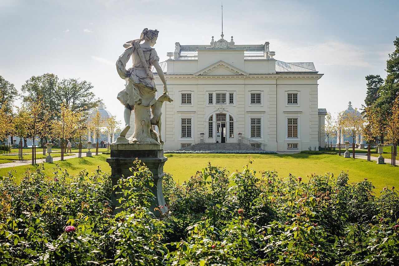
Trakai
## Description Užutrakis Manor Estate is a graceful, lakeside cultural landscape that combines manicured gardens, classical architecture, and sweeping views over Lake Galvė just outside Trakai. The estate preserves the atmosphere of late 19th– and early 20th-century leisure gardens while adapting to contemporary cultural life: restored terraces, thoughtfully composed alleys, sculptures, and scenic viewpoints frame the manor house and connect the property visually and historically with Trakai’s iconic island castle across the water. What makes Užutrakis special is its dual character as both a preserved historic landscape and an active cultural venue. Garden designers and conservationists have worked to retain the original axes and formal layouts while integrating native plantings that support local biodiversity. The manor’s rooms and exhibition spaces are used seasonally for concerts, art shows, and local festivals, so a visit can feel both reflective and lively depending on the calendar. Photographers prize the vantage points that align with the castle silhouette on Lake Galvė, and landscape enthusiasts appreciate the blending of English-style park elements with Lithuanian plantings. For travelers seeking a slower cultural day trip from Vilnius or Vilnius airport, Užutrakis offers a concentrated experience: well-maintained paths for strolls, benches for long views, and interpretive signage that explains the estate’s history, garden features, and the restoration philosophy. Because it sits a short distance from Trakai’s main attractions, it pairs naturally with a visit to the island castle, allowing visitors to alternate between formal architecture, lakeside walks, and local food options in Trakai town. ## Location Užutrakis Manor sits on the shores of Lake Galvė within Trakai municipality, Vilnius County, central Lithuania. It lies only a short drive, bike ride, or pleasant walk from Trakai town and its famous island castle, making it an easy half-day or day-trip destination from Vilnius (about 28 kilometers away) or from Vilnius International Airport. Getting there is straightforward: regional buses and organized tours run regularly between Vilnius and Trakai, and local taxi services provide short transfers to the estate. For a more scenic approach, boat shuttles operate on Lake Galvė in the warmer months, delivering visitors to various points along the shoreline. Cyclists can combine the manor with a gentle ride around the lake, while visitors staying in Trakai can reach the gardens on foot from the town center depending on seasonal paths and local signage. ## Tips - **Combine with Trakai Castle:** Pair a morning or afternoon at Užutrakis with a visit to Trakai Castle for a varied cultural day of gardens and medieval architecture. - **Check the event calendar:** The manor hosts concerts, seasonal exhibitions, and cultural programs; aligning your visit with an event can add memorable local flavor. - **Wear comfortable shoes:** Gravel paths, terraces, and gentle slopes reward comfortable footwear; bring a light rain layer in changeable weather. - **Bring a camera and binoculars:** The viewpoints toward Trakai Castle and lakeside vistas are signature photo opportunities; binoculars help for birdwatching along the shoreline. - **Mind opening hours and fees:** The estate may have seasonal opening hours and modest fees for house access or special exhibitions. - **Respect the grounds:** Follow paths, avoid trampling sensitive plantings, and observe any interpretive guidance—this helps conserve the restored historic landscape. ## Conclusion Užutrakis Manor Estate is a graceful complement to Trakai’s island castle and regional attractions: a lakeside garden escape rich in architecture, curated views, and seasonal cultural programming. It rewards slow visits—moments of reflection on terraces, an attentive walk through historic lanes, and an appreciation for the interplay of landscape restoration and active cultural life. ## FAQ - **Q: Is there an entrance fee to Užutrakis Manor?** A: There is often a modest fee for access to the manor’s interiors or special exhibitions; garden access may be free or ticketed depending on season. Check the estate’s official site or local tourist information for current rates. - **Q: Can I tour the interior of the manor house?** A: Interior access is seasonal and may be limited during restoration or private events—plan ahead if interior tours are important to your visit. - **Q: Are events held outdoors, and do I need reservations?** A: Seasonal concerts and cultural events commonly occur outdoors; some events require advance booking while smaller activities may accept walk-up visitors. - **Q: Is the manor wheelchair or stroller accessible?** A: Accessibility varies across terraces and historic rooms; the garden paths are generally manageable, but some interior areas may have steps—contact the site for detailed accessibility information. - **Q: How long should I allocate for a visit?** A: Plan 1.5–3 hours to enjoy the gardens, viewpoints, and any small exhibitions; longer if attending a concert or combining with Trakai Castle. - **Q: Are there food options nearby?** A: Trakai town offers cafés and local eateries; pack water and light snacks if you prefer a picnic in the gardens. ## Links -- [Užutrakis Manor (Wikipedia)](https://en.wikipedia.org/wiki/U%C5%BEutrakis_Manor)
GemVoyage Team • World
Druskininkai
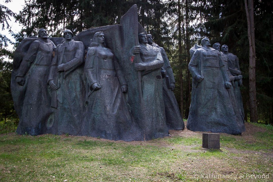
## Description Grūtas Park, often labeled the Soviet Sculpture Park, is a distinctive open-air museum near Druskininkai that preserves monumental artifacts from Lithuania’s Soviet period. Established by collectors and curators who sought to gather statues and relics removed from public squares after Lithuania regained independence, the park assembles these pieces within a designed landscape that encourages critical reflection rather than uncritical nostalgia. The park’s collection includes busts, full-figure monuments, bas-reliefs, and civic emblems that once dominated urban spaces under Soviet rule. What distinguishes Grūtas Park is its curatorial framing: statues are not simply re-installed as aesthetic objects but are placed within an interpretive environment that raises questions about ideology, power, and public memory. Complementing the sculptures are reconstructed Soviet kiosks, everyday artifacts, period signage, and a small indoor museum that provides historical context and archival material. The layout intentionally references the scale and dramatic sightlines of Soviet monumentalism, creating a spatial dialogue between past and present. Visitors often find Grūtas Park both educational and emotionally resonant. Plaques and guided tours unpack the histories behind the monuments, the artists who made them, and the social circumstances that led to their removal and relocation. The park fosters discussion about how societies remember oppressive histories, the ethics of preserving controversial monuments, and creative approaches to public history. ## Location Grūtas Park is located just outside the spa town of Druskininkai in southern Lithuania’s Alytus County, within easy driving distance of Vilnius and Kaunas. The park sits near major regional roads and is well signposted. Travel options include driving by car (the most flexible), regional buses that connect Druskininkai to surrounding towns, and organized day trips from Vilnius or Kaunas. Many visitors combine Grūtas Park with the spa facilities and cultural attractions of Druskininkai for a varied day trip. ## Tips - **Allow sufficient time:** Allocate 1.5–3 hours to walk the outdoor sculpture trails, visit the small museum, and absorb the interpretive materials. - **Use audio guides or join a guided tour:** Contextual information deepens understanding far beyond a walk-by view of statues—learn about the artists, the historical narratives, and the curatorial choices. - **Prepare for emotional responses:** The park’s material can be confronting. Read curator notes and plaques to frame the objects within a critical history of occupation and memory. - **Combine with Druskininkai activities:** Pair the visit with spa treatments, local museums, or nature walks to vary the day’s tone. - **Respect interpretive rules:** Photography is usually allowed for personal use, but check signage for restricted areas or displays. ## Conclusion Grūtas Park offers a unique encounter with Lithuania’s Soviet past: a landscaped gallery of monumental relics curated to foster reflection rather than nostalgia. Whether you are a history buff, art enthusiast, or traveler seeking thoughtful cultural experiences, the park provides a powerful case study in how societies can engage with difficult heritage. ## FAQ - **Q: Is Grūtas Park suitable for families with children?** A: The park is accessible to families, but the themes and imagery can be disturbing to very young children. Parents should prepare to explain historical context and may prefer guided tours that provide age-appropriate framing. - **Q: Are the sculptures authentic originals?** A: Many of the monuments on display were relocated from public squares and municipal collections across Lithuania; in several cases these are original works by mid-20th-century artists. - **Q: Can I take photographs at Grūtas Park?** A: Photography for personal use is generally allowed across the outdoor exhibits; check for any restricted areas or special installations where signage limits photography. - **Q: How much time should I plan for a visit?** A: Plan 1.5–3 hours to experience both the outdoor sculpture trail and the indoor exhibits, and longer if you want to read detailed materials or join a guided program. - **Q: Is there an admission fee?** A: Yes, the park charges an entry fee that helps support maintenance and interpretive programming—confirm current prices on the park’s official site. - **Q: Does the park host temporary exhibitions or events?** A: Grūtas Park occasionally runs temporary exhibitions, film screenings, and guided talks—check the calendar if you want to coincide with special programming. ## Links -- [Grūtas Park (Wikipedia)](https://en.wikipedia.org/wiki/Gr%C5%ABtas_Park)
GemVoyage Team • World
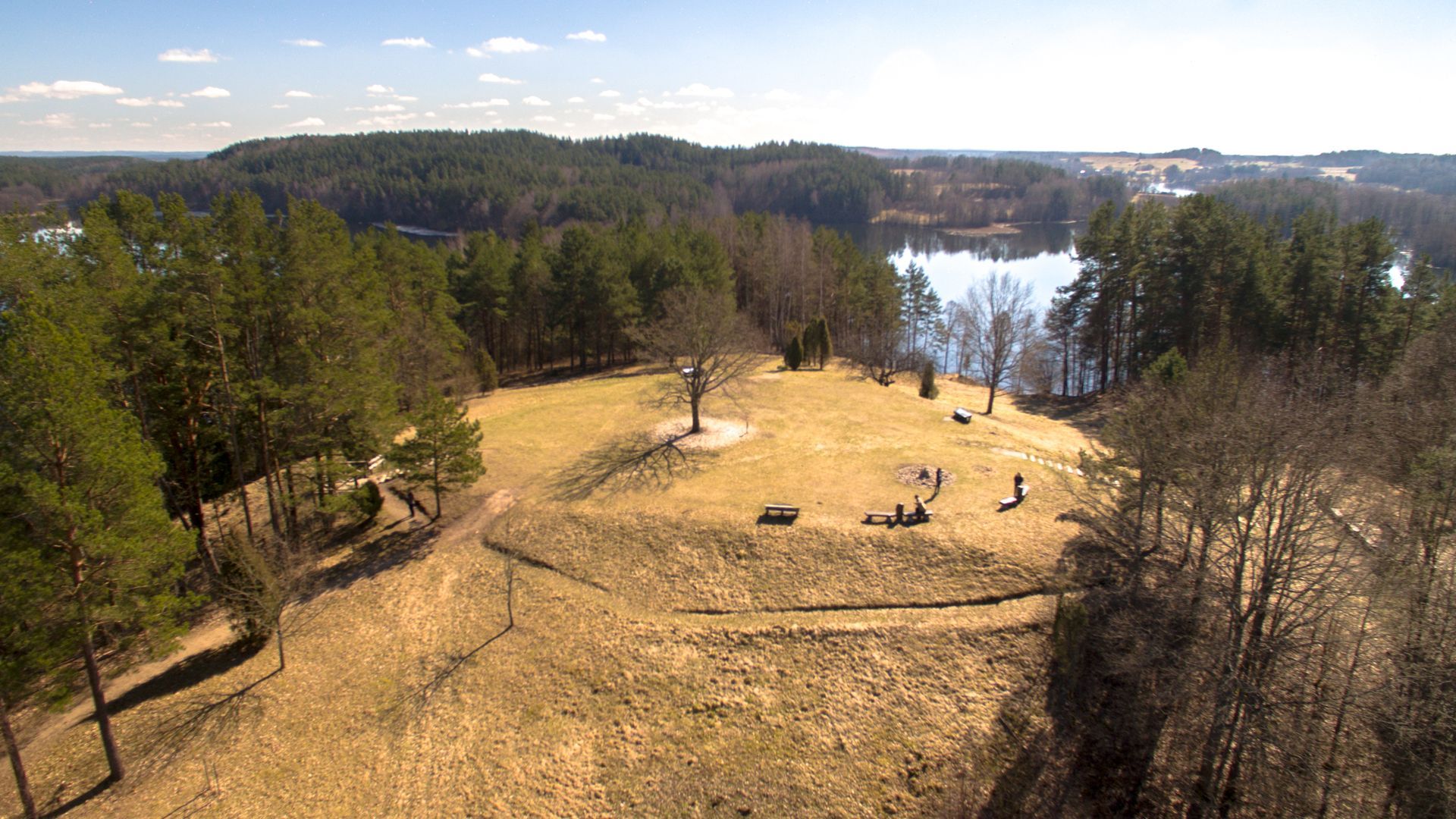
Ignalina
## Description Ladakalnis is a scenic hill in northeastern Lithuania, celebrated for panoramic views that sweep across a chain of lakes, boglands, and mixed forest typical of the Aukštaitija region. The hill’s exposed viewpoints reveal an interlocking pattern of water and woodland that feels deeply characteristic of the Baltic landscape—quiet lakes framed by birch and pine, rippling reed beds, and a largely undeveloped horizon that invites contemplative walks and photography. Beyond its scenic value, Ladakalnis carries cultural resonance. Historically a meeting place and, in local traditions, associated with pre-Christian ritual activities, the hill has hosted small folklore events and seasonal gatherings through the centuries. Modest archaeological traces nearby suggest long-term human use of the area, while modern conservation efforts keep the trails accessible and the ecosystem intact. Visitors come for sunrise and sunset views, birdwatching, and gentle hikes that do not require advanced equipment but repay visitors with memorable vistas. ## Location Ladakalnis sits near the town of Ignalina in Utena County, northeastern Lithuania, within the broader area associated with Aukštaitija National Park and its lakes. The region is popular with nature enthusiasts for its clean waters, preserved shorelines, and well-managed recreational infrastructure. Access is easiest by car from Ignalina or nearby towns; local roads and signage lead to modest parking areas close to the trailhead. Public transport options may include regional buses to Ignalina, after which a short taxi ride or arranged shuttle can bring you to the site. Because the area is rural, plan transfers in advance if you do not have a private vehicle. ## Tips - **Time your visit for light and solitude:** Sunrise and late afternoon provide the best light for photography and the calmest atmosphere. - **Bring optics and field guides:** Binoculars and a basic bird or plant guide enhance the experience for birdwatching and identifying regional flora. - **Wear good footwear:** Paths can be rocky and uneven in places—sturdy shoes or trail runners are recommended. - **Pack essentials:** Carry water, snacks, and weather-appropriate layers; top facilities may be limited. - **Combine with nearby nature activities:** Pair this short hike with a boat excursion, a canoe trip, or additional trails in Aukštaitija National Park for a fuller outdoor itinerary. ## Conclusion Ladakalnis is an inviting short excursion that rewards modest effort with expansive Baltic panoramas. It’s well suited for photographers, families, and hikers seeking a contemplative outdoor experience anchored in both scenic beauty and local tradition. ## FAQ - **Q: How difficult is the hike to the summit?** A: The walk is moderate and accessible to most visitors with basic fitness; trail length and gradient are manageable but wear suitable footwear. - **Q: Are the trails clearly marked?** A: Local paths and signage guide visitors to the viewpoint, though markers can be sparse in places—carry a map or GPS track if you prefer added reassurance. - **Q: Is camping allowed near Ladakalnis?** A: Wild camping is generally discouraged in protected zones—use established campsites in Aukštaitija National Park and follow local regulations. - **Q: When is the best time for birdwatching?** A: Spring migration and early summer offer abundant bird activity; dawn and dusk are particularly productive for raptors and waterbirds. - **Q: Are there restroom or food facilities?** A: Facilities at the top are limited. Plan to bring water and snacks or return to nearby towns for services. ## Links -- [Ladakalnis](https://www.aparkai.lt/en/sightseeing-places/ladakalnis/)
GemVoyage Team • World
Lisbon
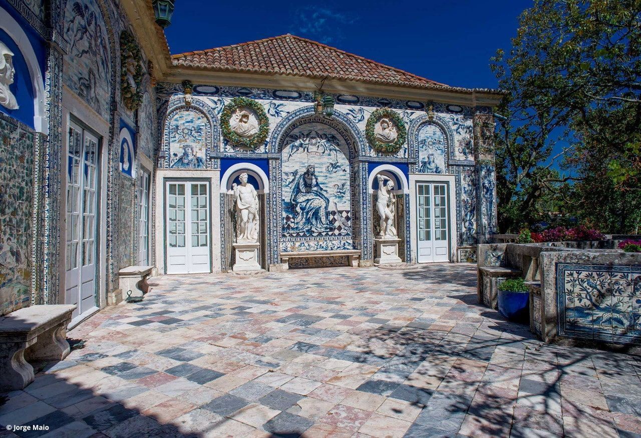
## Description Palácio dos Marqueses de Fronteira is an elegant, family-owned 17th-century estate on the edge of Lisbon that delights visitors with its exceptional azulejo tile panels, intimate museum rooms, and meticulously designed gardens. The palace feels less like a public museum and more like entering a well-preserved private residence that has been lived in and cared for by the same lineage of nobility for centuries. Interiors display an array of period furniture, heirloom portraits, and decorative arts that create a layered sense of domestic aristocratic life. The palace’s defining artistic draw is its azulejo program: large narrative tile panels that record hunting scenes, mythological episodes, allegories, and courtly imagery, executed in the refined blue-and-white and polychrome palettes typical of the 17th and 18th centuries. These tiles cover interior and exterior walls, forming pictorial narratives that reward close looking. Complementing the tiles are frescoes, gilded frames and sculptural elements that reflect Baroque and Rococo tastes adapted to Portuguese sensibilities. The gardens are a major reason to visit. Laid out with geometric hedges, elegant statuary and reflecting pools, they weave Moorish and Renaissance influences into a distinctly Portuguese landscape grammar. Garden rooms framed by clipped yews and boxwood create intimate vistas, while larger terraces open to sweeping views of the surrounding neighborhood. Seasonal plantings and careful maintenance mean the palace is beautiful year-round, although spring and early summer are especially lush. Conservation and stewardship at the palace are noteworthy: the family’s ongoing custodianship has supported careful tile restoration projects and the preservation of original material culture. Many of the conservation interventions have been carried out by local artisans using traditional techniques, preserving not just objects but craft knowledge. Photographic and accessibility note: photographers should plan for a mix of wide-angle shots of garden terraces and close-ups of tile details; early morning light reduces harsh shadows on glazed surfaces. Visitors requiring mobility assistance should contact palace staff ahead of time to arrange the smoothest route through garden paths and to confirm which rooms are accessible. ## Location The palace is located in the Benfica neighborhood of Lisbon, a short drive northwest of central districts like Rossio and Baixa. From the historic center, it typically takes 15–25 minutes by car depending on traffic. Public transit options involve buses and sometimes a combination of tram and bus; travelers should allow extra time for connections and walking to the palace grounds. Getting there: taxis and rideshares are convenient and typically the fastest way for visitors without a car. If using public transport, check current bus routes and schedules and allow for a short walk from the nearest stop to the palace entrance. ## Tips - Book tickets in advance when possible; guided tours are often limited and sell out during peak season. - Wear comfortable shoes: garden paths include gravel and uneven surfaces. - Respect interior rules: certain rooms may be closed or restricted for conservation reasons; photography inside may be limited. - Bring a camera and consider different lenses: a wide-angle captures garden vistas while a close lens helps study tile details. - Time your visit: visit in the morning light for softer photographs and more tranquil garden conditions. - Combine visits: pair the palace with nearby cultural sites such as the National Coach Museum or a walk in Monsanto Forest Park for a varied day. ## Conclusion Palácio dos Marqueses de Fronteira is a quietly grand escape from Lisbon’s busiest tourist routes. It rewards the patient visitor — those who enjoy architectural decoration, tile art and carefully tended gardens — with an intimate glimpse of aristocratic Portuguese life. The palace’s careful preservation and the family’s ongoing care make it a dignified and deeply rewarding stop on a cultural itinerary. ## FAQ Q: Are guided tours available? A: Yes. Guided tours are offered and provide detailed historical context about the palace, its tiles and the family’s history. Check the palace’s official website or local tourism resources for times and booking procedures. Q: Is the palace wheelchair accessible? A: Accessibility is limited in some historic rooms and garden areas due to steps and uneven terrain. Contact the palace in advance to discuss specific access requirements and to learn which sections are accessible. Q: Can I photograph inside the palace and gardens? A: Photography is usually permitted in the gardens; some interior rooms may restrict photography to protect delicate materials. Always follow posted signs and staff instructions. Q: How long should I allow for a visit? A: Plan for 1–2 hours to see the main rooms and stroll the gardens at a relaxed pace. If you are a tile or garden enthusiast, you may wish to allow more time. Q: Are there any special events or seasonal highlights? A: The palace occasionally hosts concerts, temporary exhibitions, or guided thematic tours. Spring and early summer offer peak garden blooms and are popular times to visit. ## Links - [Wikipedia: Palácio dos Marqueses de Fronteira](https://en.wikipedia.org/wiki/Palace_of_the_Marquises_of_Fronteira)
GemVoyage Team • World