GemVoyage Team • World
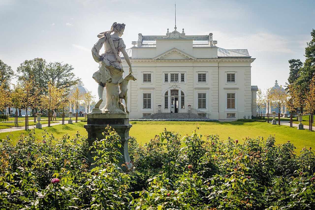
What makes Užutrakis special is its dual character as both a preserved historic landscape and an active cultural venue. Garden designers and conservationists have worked to retain the original axes and formal layouts while integrating native plantings that support local biodiversity. The manor’s rooms and exhibition spaces are used seasonally for concerts, art shows, and local festivals, so a visit can feel both reflective and lively depending on the calendar. Photographers prize the vantage points that align with the castle silhouette on Lake Galvė, and landscape enthusiasts appreciate the blending of English-style park elements with Lithuanian plantings.
For travelers seeking a slower cultural day trip from Vilnius or Vilnius airport, Užutrakis offers a concentrated experience: well-maintained paths for strolls, benches for long views, and interpretive signage that explains the estate’s history, garden features, and the restoration philosophy. Because it sits a short distance from Trakai’s main attractions, it pairs naturally with a visit to the island castle, allowing visitors to alternate between formal architecture, lakeside walks, and local food options in Trakai town.
Getting there is straightforward: regional buses and organized tours run regularly between Vilnius and Trakai, and local taxi services provide short transfers to the estate. For a more scenic approach, boat shuttles operate on Lake Galvė in the warmer months, delivering visitors to various points along the shoreline. Cyclists can combine the manor with a gentle ride around the lake, while visitors staying in Trakai can reach the gardens on foot from the town center depending on seasonal paths and local signage.
Discover more hidden gems you might love.
Berlin
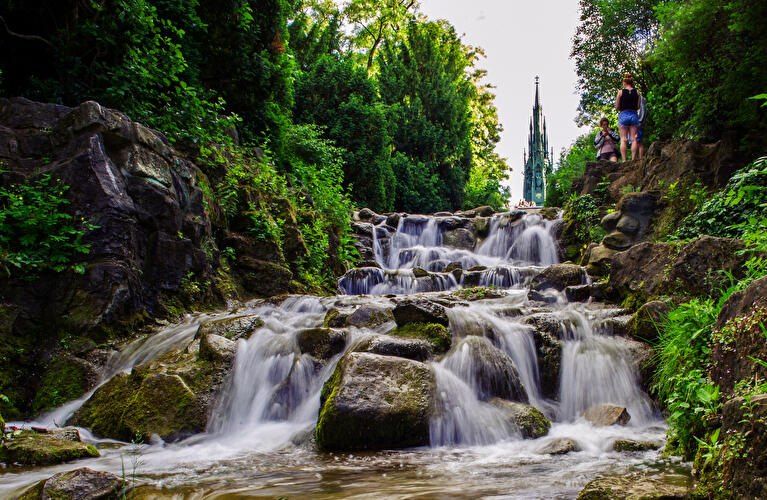
## Description **Viktoriapark** is one of Berlin’s most distinctive urban green spaces, combining **natural elevation, engineered waterfalls, panoramic city views, and national symbolism** within a compact yet dramatic landscape. Unlike Berlin’s vast flat parks such as Tiergarten or Tempelhofer Feld, Viktoriapark stands out because it rises sharply above the surrounding streets, offering one of the **best natural viewpoints in the entire city**. The park is centered around **Kreuzberg Hill**, a 66-meter-high elevation that gives the surrounding district its name. At the summit stands the imposing **National Monument for the Wars of Liberation** (Nationaldenkmal für die Befreiungskriege), a Gothic-style cast-iron monument designed by **Karl Friedrich Schinkel** and completed in 1821. The monument commemorates Prussia’s victory over Napoleon and represents one of the earliest major patriotic memorials in Germany. Its dark, spired form creates a dramatic silhouette against the sky and serves as a visual anchor for the entire park. One of Viktoriapark’s most beloved features is its **artificial waterfall system**, which cascades down the eastern slope of the hill toward Kreuzbergstraße. Built in the late 19th century, the waterfall was designed to mimic alpine mountain streams, bringing the sound, movement, and cooling atmosphere of flowing water into the dense urban fabric. During warm months, these waterfalls become the emotional heart of the park—children play at the base, couples sit on the stone steps, and photographers wait for light to catch the moving water. What makes Viktoriapark particularly compelling is the way it merges **romantic landscape design with political history**. The hill was reshaped during the 19th century to fit the ideals of romantic nationalism, where nature, sacrifice, and monumentality were meant to reinforce each other. The result is a park that feels both organic and highly symbolic at the same time. A little-known fact is that Kreuzberg Hill was once part of a **vine-growing region**, and small-scale wine production existed here in earlier centuries. Even today, a modern vineyard operates on the slope near the monument, producing limited local wine each year. Another lesser-known detail is that the waterfall only runs during the warmer months, meaning many winter visitors never realize that this dramatic feature exists at all. Beyond its historical symbolism, Viktoriapark plays a vital role in everyday neighborhood life. It is a **local refuge** for residents of Kreuzberg, attracting joggers, families, musicians, dog walkers, and sunset watchers. Unlike some of Berlin’s more monumental parks, Viktoriapark maintains a **distinctly neighborhood-driven character**, blending tourism and local daily rhythm without feeling staged. Emotionally, the park shifts moods throughout the day. Mornings are quiet and misty along the lower paths. Afternoons bring activity and movement. Evenings transform the summit into a gathering point for people watching the sun sink behind Berlin’s rooftops. From the top, visitors can often see landmarks such as the **TV Tower (Fernsehturm)** and distant church spires, reinforcing the sense of standing above the city without ever leaving it. ## Location **Viktoriapark** is located in the **Kreuzberg district of central Berlin**, close to the border with Schöneberg. **City:** Berlin **Region:** Berlin (city-state) **Country:** Germany **District:** Kreuzberg (Friedrichshain-Kreuzberg borough) ### How to Get There: * **By U-Bahn:** * **Line U6** to **Platz der Luftbrücke**, then walk about 10 minutes. * **Line U7** to **Mehringdamm**, then walk about 12–15 minutes. * **By bus:** Several bus lines stop along Mehringdamm and Kreuzbergstraße. * **By bicycle:** Well connected by bike lanes and ideal as part of a Kreuzberg cycling route. * **By taxi or ride-hailing apps:** Direct access from anywhere in central Berlin. * **On foot:** Easily reachable from Bergmannkiez and Tempelhofer Damm areas. The park’s elevated position makes it visible from many surrounding streets, acting as a **natural landmark within Kreuzberg**. ## Tips * **Visit near sunset:** The panoramic view from the monument is one of the best free sunset spots in Berlin. * **Check if the waterfall is running:** It is typically active only from spring to autumn. * **Wear comfortable shoes:** The paths include steep inclines and irregular stone steps. * **Bring a light jacket:** Wind at the top can be significantly stronger than street level. * **Combine with Bergmannkiez:** The surrounding neighborhood is full of cafés, bakeries, and local restaurants. * **Avoid peak hours for quiet time:** Late afternoons on weekends can be crowded. * **Respect the monument:** It is a protected historical site, not a climbing structure. * **Photography tip:** Early morning light illuminates the eastern slope and waterfall beautifully. ## Conclusion **Viktoriapark** is a rare Berlin green space where **natural elevation, romantic landscape design, national history, and everyday local life intersect**. From its cascading waterfalls and shaded paths to the solemn monument crowns its summit, the park offers both emotional contrast and visual depth. It is not grand in size, but in **experience, symbolism, and atmosphere**, it ranks among the most memorable outdoor spaces in the city. ## FAQ **1. What is Viktoriapark famous for?** It is best known for its **hilltop national monument, artificial waterfalls, and panoramic city views**. **2. Is Viktoriapark suitable for children?** Yes. Families visit frequently, especially near the lower waterfall areas, though supervision is required due to rocky terrain. **3. Is there an entrance fee?** No. Viktoriapark is **free and open to the public**. **4. Does the waterfall run all year?** No. It usually operates **only during the warmer months**. **5. Can you see major landmarks from Viktoriapark?** Yes. On clear days, you can spot parts of the **Berlin skyline including the TV Tower**. **6. How long should a visit take?** Most visits last **45 minutes to 1.5 hours**, depending on walking pace and time spent at viewpoints. ## Links * [Official Berlin Parks Page](https://www.berlin.de/tourismus/parks-und-gaerten/3560783-1740419-viktoriapark.html)
GemVoyage Team • World
Milan
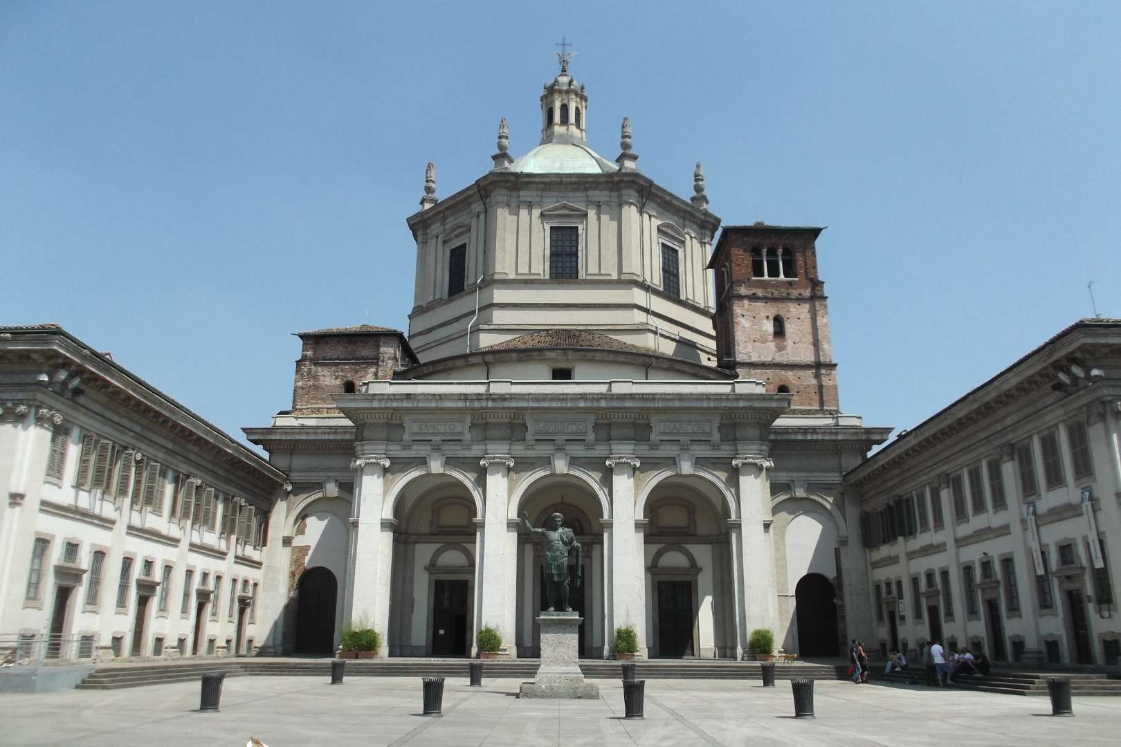
## Description The Basilica of San Lorenzo Maggiore in Milan is one of the city’s oldest and most architecturally intriguing churches, offering a rich tapestry of history, religion, and design. Originally constructed between the late 4th and early 5th centuries, the basilica has undergone numerous reconstructions, resulting in a unique blend of Early Christian, Renaissance, and Baroque styles. Its imposing central dome and symmetrical layout make it a standout among Milan’s ecclesiastical landmarks. What sets San Lorenzo apart is its daring architectural originality. Art historians have noted its resemblance to the great churches of Constantinople, many of which no longer exist. The basilica’s interior features elegant marble columns, intricate mosaics, and the stunning Chapel of Saint Aquilino, which houses 4th-century Byzantine mosaics and remnants of Roman construction materials. Outside, the Colonne di San Lorenzo—sixteen Roman columns dating from the 3rd century—stand as a dramatic prelude to the church and are among the few surviving relics of ancient Mediolanum. A little-known fact: archaeological investigations suggest that the basilica may have been built atop a Roman amphitheater, and some of its foundational materials were repurposed from other Roman sites. Another fascinating detail is that the basilica’s dedication to Saint Lawrence was only confirmed in 590 AD, long after its initial construction. ## Location The Basilica of San Lorenzo Maggiore is located in **Italy**, in the **Lombardy region**, within the **city of Milan**. Its exact address is **Corso di Porta Ticinese, 39**, situated near the medieval Porta Ticinese and within walking distance of the Navigli district and the city center. ### How to Get There - **By Metro**: Take Line M2 to Sant’Ambrogio or Line M3 to Missori, then walk about 10–15 minutes. - **By Tram**: Tram line 3 stops at “Ticinese Molino delle Armi,” just steps from the basilica. - **By Foot**: From the Duomo, it’s a pleasant 15-minute walk through historic streets. - **By Bike or Scooter**: Milan’s bike-sharing and e-scooter services offer a scenic and efficient way to reach the basilica. Its central location makes it easy to include in a day of sightseeing, especially when paired with nearby attractions like the Basilica of Sant’Eustorgio or the Navigli canals. ## Tips - **Visit the Chapel of Saint Aquilino**: Don’t miss this side chapel, which contains some of the oldest mosaics in Milan and offers a glimpse into the city’s Roman past. - **Go Early or Late**: The basilica is less crowded in the morning or late afternoon, allowing for a more peaceful visit. - **Dress Modestly**: As with all religious sites, respectful attire is recommended. - **Explore the Piazza**: The square in front of the basilica is lively and atmospheric, often filled with street performers and locals. - **Check for Mass Times**: If you’re interested in attending a service, consult the basilica’s schedule in advance. - **Photography**: Photos are allowed, but avoid flash and be mindful during services. ## Conclusion Basilica San Lorenzo Maggiore is a captivating blend of ancient history and spiritual heritage. With its Roman columns, Byzantine mosaics, and architectural grandeur, it offers a compelling experience for anyone exploring Milan’s rich cultural landscape. ## FAQ **1. Is there an entrance fee to visit the basilica?** No, entry to the basilica is free. Donations are welcome. **2. What are the opening hours?** Monday to Friday: 8:00 AM – 12:30 PM and 3:00 PM – 6:30 PM Saturday and Sunday: 9:00 AM – 1:00 PM and 3:00 PM – 7:00 PM **3. Can non-Catholics visit the basilica?** Yes, the basilica is open to all visitors, regardless of religious background. **4. Is the basilica wheelchair accessible?** Some areas may be challenging due to steps and uneven flooring, but the main entrance and nave are generally accessible. **5. Are guided tours available?** Yes, some local tour operators include San Lorenzo in their walking tours of Milan’s historic center. **6. What is the best time of year to visit?** Spring and autumn offer mild weather and fewer crowds, making them ideal for sightseeing. ## Links - [Basilica of San Lorenzo – Wikipedia Overview](https://en.wikipedia.org/wiki/Basilica_of_San_Lorenzo,_Milan) - [San Lorenzo Maggiore – Official Website](http://www.sanlorenzomaggiore.com/)
GemVoyage Team • World
Poznan
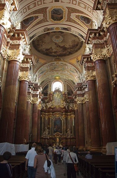
## Description Fara Church, officially known as **The Parish Church of St. Stanislaus (Fara Church)**, is one of the most magnificent Baroque buildings in Poland and a must-visit attraction in Poznań. Built in the **17th century** by Jesuits, it has become a symbol of Poznań’s religious and architectural heritage. With its richly decorated interior, fresco-covered ceilings, and breathtaking altars, it is often considered one of the most beautiful Baroque churches in Europe. What makes the Fara Church unique is not only its grandeur but also the **acoustics** that make it a popular venue for organ concerts. The church houses an impressive **pipe organ with over 2,000 pipes**, and visitors are often treated to free concerts showcasing the instrument’s power and elegance. A little-known fact about the church is that beneath it lies a series of **underground chambers** and crypts, some of which are occasionally open to the public during guided tours. Another interesting detail is the presence of **trompe-l’œil painting techniques** inside, which create optical illusions, making the decorations appear three-dimensional and more elaborate than they actually are. ## Location Fara Church is located in **Poznań, Poland**, in the **Greater Poland region**. It stands in the **Old Town district**, just a short walk from the famous **Old Market Square (Stary Rynek)**. The church’s location in the historic heart of the city makes it easy to combine a visit with other nearby attractions such as the Town Hall and the Royal Castle. ### Recommendation on How to Get There From **Poznań Główny railway station**, you can take a tram to **Wrocławska or Marcinkowskiego stops**, and from there, it’s only a few minutes’ walk to the church. For those already in the city center, Fara Church is easily accessible on foot. If you’re arriving by car, it’s recommended to park in one of the nearby parking facilities since the Old Town area has limited vehicle access. ## Tips To make your visit to Fara Church in Poznań truly memorable, here are some practical tips: * **Visit During Concerts**: Try to attend one of the free or low-cost organ concerts held regularly inside the church. The acoustics are remarkable. * **Guided Tours**: If available, join a guided tour to access the underground chambers and learn about the Jesuit history of the church. * **Photography**: Bring a camera, but be mindful of ongoing services and respect worshippers. The light filtering through stained glass windows creates stunning photo opportunities. * **Timing**: Visit in the morning or late afternoon when the church is quieter, as midday tends to attract more tourists. * **Combine with Old Town Walk**: Since it’s centrally located, you can easily combine your visit with a stroll through the Old Market Square and surrounding historic streets. * **Respect the Atmosphere**: Remember that Fara Church is still an active place of worship, so dress modestly and remain quiet during services. ## Conclusion Fara Church in Poznań is a masterpiece of Baroque architecture and a cultural highlight of the city. With its ornate interior, fascinating history, and world-class acoustics, it offers a unique experience for visitors interested in history, art, or music. A trip to Poznań wouldn’t be complete without stepping inside this architectural gem. ## FAQ **1. What is the full name of Fara Church?** Its official name is the Parish Church of St. Stanislaus (Fara Church). **2. Is there an entrance fee to visit the church?** No, entry is free, though donations are welcome. Special guided tours or concerts may have a small fee. **3. Can tourists attend religious services?** Yes, but visitors are asked to remain respectful and quiet during services. **4. What makes the church special compared to others in Poznań?** Its Baroque design, richly decorated interior, and famous pipe organ make it one of the most outstanding churches in Poland. **5. Is the church accessible for people with disabilities?** The main entrance is accessible, but some underground chambers may not be suitable for those with mobility issues. **6. How long does a visit usually take?** A typical visit lasts **30 minutes to 1 hour**, but if you attend a concert or guided tour, you might stay longer. ## Links * [Official website of Fara Church](https://fara.archpoznan.pl/pl/) * [Poznań Tourism Office](https://visitpoznan.pl/en)
GemVoyage Team • World
Stockholm
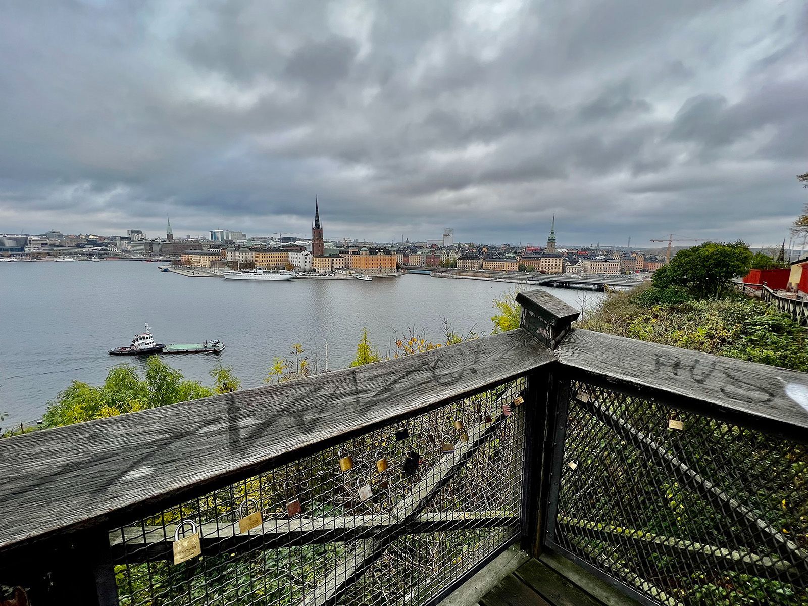
## Description Monteliusvägen is one of Stockholm’s most beloved viewpoint walks because it offers a remarkable amount of scenery for very little effort. Stretching along Mariaberget in Södermalm, the path gives visitors panoramic views over Riddarfjärden, City Hall, and the water and skyline that define Stockholm’s visual identity. It is a place where walking becomes part of the sightseeing itself, and where the city looks especially elegant in changing light. The viewpoint’s appeal lies in its mixture of accessibility and atmosphere. You do not need to climb a mountain or travel far from the center to get a memorable outlook. Instead, you can step into a residential and elevated part of the city and find a broad view that feels almost theatrical. One little-known fact is that Monteliusvägen is particularly admired by locals for how reliably it delivers a strong skyline view without the crowds associated with more obvious tourist stops. Another is that the path changes character with the seasons; winter can make the scenery crisp and graphic, while summer brings long, luminous evenings and a more relaxed mood. What also makes Monteliusvägen special is that it combines motion and pause. As you walk, the city opens and closes in layers. You might pass benches, low walls, and quiet residential details, then suddenly find a view that feels worthy of a postcard. That rhythm encourages visitors to slow down rather than rush through. It is a great place to arrive without a fixed plan, because the reward comes from both the walk and the destination. For photographers and casual visitors alike, the viewpoint is one of Stockholm’s most satisfying urban experiences. It captures the city’s relation to water, its elegant low-rise skyline, and its subtle balance between nature and urban form. A sunset visit can be particularly memorable, but the viewpoint works at many times of day because the geometry of the city and the water remains compelling even in flat light. ## Location Monteliusvägen is located on Mariaberget in Södermalm, Stockholm, Sweden, overlooking the waters of central Stockholm. It is very close to the city core, which makes it easy to include in a broader city walk. Because it sits on a ridge above the water, the route includes some uphill movement, but the climb is short and manageable. The easiest access is via Stockholm’s metro system to nearby stations such as Slussen, followed by a walk through Södermalm. From there, signage and local navigation are usually straightforward enough for most visitors to find the viewpoint. Since the area is so central, it is simple to pair it with a coffee stop, dinner, or a longer Södermalm exploration. If you want the best photo conditions, go near sunset or during the soft light of early morning. For a quieter experience, avoid peak sightseeing hours when possible. ## Tips - Go at sunset if you want the most dramatic light on the water and skyline. - Wear comfortable shoes because the approach includes some uphill walking. - Bring a jacket or layer, especially if you stay after sunset when wind can feel cooler. - Walk slowly and stop more than once. The viewpoint changes as you move along it. - Combine Monteliusvägen with another Södermalm stop so the outing feels complete. ## Conclusion Monteliusvägen is one of Stockholm’s most rewarding short walks, offering a classic view of the city with little logistical effort. It is simple, beautiful, and especially strong at sunset. ## FAQ ### Is Monteliusvägen worth it if I have only one day in Stockholm? Yes. It is one of the quickest ways to get a memorable city view without a complicated excursion. ### How long is the walk? The walking stretch is fairly short, but you will likely spend more time stopping to enjoy the views than actually moving. ### Is it very crowded? It can be popular, especially around sunset, but it still often feels calmer than the most famous Stockholm viewpoints. ### Is it family-friendly? Yes, as long as everyone is comfortable with a little uphill walking and staying attentive near ridge-edge paths. ## Links - [Visit Stockholm](https://www.visitstockholm.com/)
GemVoyage Team • World
Tunis
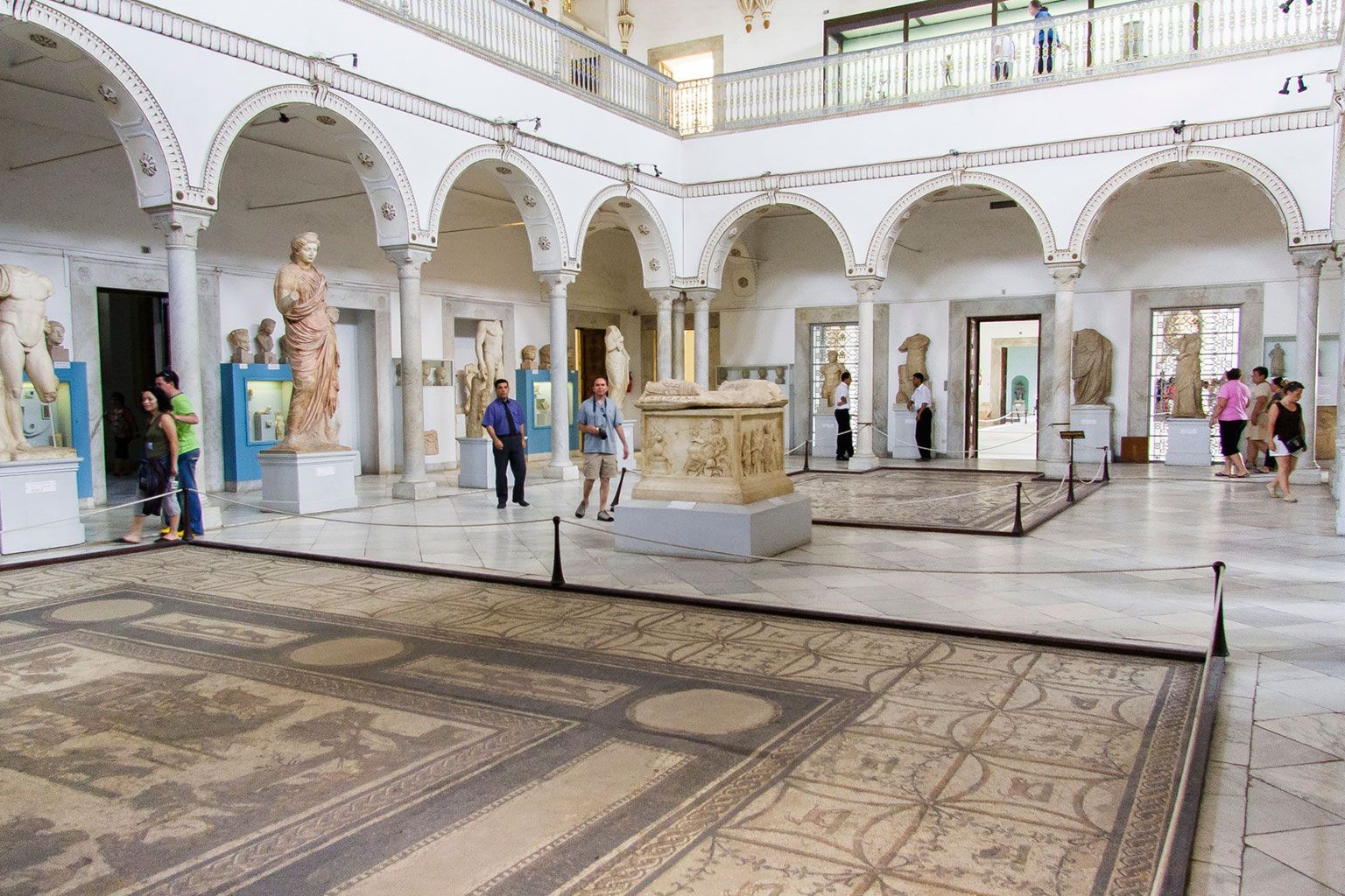
## Description Bardo National Museum is one of North Africa’s most important museums and a highlight for anyone interested in archaeology, history, and art. It is particularly famous for its extraordinary collection of Roman mosaics, but the museum’s significance goes beyond a single category. It offers a broad journey through Tunisia’s layered past, from prehistoric materials and Punic remains to Islamic-era objects and decorative arts. That range makes it one of the best places to understand how many different civilizations have shaped the country. What makes the Bardo especially memorable is the quality of the collection and the setting in which it is displayed. The museum occupies a former palace complex, and that architectural backdrop gives the exhibits a sense of elegance and continuity with the past. Walking through the galleries feels like moving through a living archive. The mosaics are often the first thing people mention, and for good reason: they are vivid, large, and remarkably well preserved. But there is also a quieter pleasure in discovering smaller objects, inscriptions, and artifacts that reveal daily life, trade, belief, and artistic taste across centuries. One little-known fact is that the museum’s collection is not only important for Tunisia, but for the broader Mediterranean world. Many of the objects speak to the country’s position as a crossroads of empires, shipping routes, and cultural exchange. Another is that the palace setting helps create a more immersive experience than a plain modern gallery might. The rooms, courtyards, and architectural details remind you that the museum itself is part of Tunisia’s heritage story. For travelers, the Bardo works well because it gives context to the rest of a Tunis itinerary. If you have already seen medinas, ruins, or coastal sites, the museum ties many of those threads together. It is not just about looking at beautiful objects. It is about seeing how Tunisia’s geography and history produced a remarkably rich material culture. ## Location Bardo National Museum is in Le Bardo, a suburb just west of central Tunis, Tunisia. Its position outside the old medina makes it easy to reach while still being close enough to the capital to fit into a normal sightseeing day. The most practical way to get there is by taxi or local transport from central Tunis. Because the museum is a major institution, drivers will usually know it well. If you are already exploring Tunis, it is straightforward to combine the museum with a medina visit or another city-center stop. The museum is also a sensible first stop if you want historical context before branching out to other parts of Tunisia. Plan enough time for a proper visit. The collection is substantial, and rushing would mean missing some of the strongest mosaics and broader historical displays. This is best approached as a serious museum outing rather than a quick photo stop. ## Tips Start with the mosaics if you are short on time, but do not skip the rest of the museum. Some of the most rewarding moments come from smaller objects that are easy to overlook. Check opening information before you go, especially if your trip is part of a tight itinerary. Museums sometimes have schedule changes, and it is better to confirm in advance. If you are interested in ancient history, a guide or a bit of background reading will help you get more out of the collection. The objects are impressive on their own, but the context makes them much richer. Allow time to walk slowly through the galleries. The Bardo is not only about seeing famous pieces; it is also about noticing the range and depth of Tunisia’s past. ## Conclusion Bardo National Museum is an essential Tunis attraction for anyone who wants to understand Tunisia’s artistic and historical heritage. Its mosaics, palace setting, and wide-ranging collections make it one of the region’s most important museums. ## FAQ **What is the Bardo Museum best known for?** Its Roman mosaics are among the most famous in the Mediterranean world. **How much time should I spend there?** At least two hours is a good baseline, and more is better if you want to see the museum thoroughly. **Is it easy to get to from central Tunis?** Yes. It is in Le Bardo and can be reached conveniently by taxi or local transport. **Is the museum only about Roman history?** No. It covers a much wider range of Tunisia’s history and culture. **Is it suitable for first-time visitors to Tunis?** Absolutely. It is one of the most useful places to visit early in a trip. ## Links - [Official Website](http://bardomuseum.tn/index.php?lang=en)
GemVoyage Team • World
Vancouver
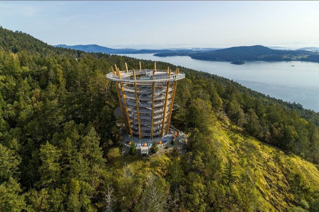
## Description The **Malahat SkyWalk Spiral Tower** is one of Canada’s most spectacular outdoor attractions, offering visitors an unforgettable way to experience the natural beauty of Vancouver Island. This unique tower features a gently sloping spiral ramp that winds its way upward for over 600 meters, leading to a stunning 250-meter elevated walkway through the treetops. At the very top, visitors are rewarded with **360-degree panoramic views** of the Saanich Peninsula, the Gulf Islands, Mount Baker in Washington State, and even glimpses of the Coast Mountains. What makes this destination truly remarkable is its **architectural design that blends seamlessly into nature**. The tower is constructed primarily from locally sourced Douglas fir and steel, combining eco-friendly practices with modern engineering. Unlike traditional observation decks, the spiral walkway makes it fully accessible to people of all ages and mobility levels. A little-known fact about the Malahat Spiral Tower is the **adventure net**—a giant webbed net suspended high above the ground at the tower’s summit. Brave visitors can step onto it and look straight down through the open center of the tower for a thrilling perspective. Another hidden gem is the **45-meter-long spiral slide** that winds its way down the inside of the tower, offering kids and adults alike an exciting alternative to walking back down. ## Location The Malahat SkyWalk Spiral Tower is located on **southern Vancouver Island, British Columbia, Canada**, about 35 kilometers (roughly 40 minutes) north of **Victoria**, the provincial capital. It sits along the Malahat Highway (Highway 1), a scenic route known for its breathtaking coastal views and winding mountain roads. The attraction is easily accessible by car, making it a popular day trip from Victoria. Visitors traveling from Vancouver can reach it by taking a ferry to Swartz Bay and then driving south toward Victoria before heading north on the Malahat Highway. For those without a car, guided tours from Victoria are also available and often include other nearby highlights. **Recommendation:** If possible, plan your visit in the morning to avoid crowds and enjoy the crisp air and soft lighting, which make the views even more magical. ## Tips To make the most out of your visit to the Malahat Spiral Tower, here are some helpful tips: * **Wear comfortable shoes:** The spiral ramp is easy to walk but requires a fair bit of strolling, so good footwear makes the experience more enjoyable. * **Check the weather:** The best views are on clear days when you can see as far as Mount Baker and the Gulf Islands. * **Try the slide:** Don’t miss the spiral slide inside the tower—it’s safe, fun, and a unique way to descend. * **Bring a camera or binoculars:** Wildlife sightings are common, including eagles, ravens, and deer in the surrounding forest. * **Buy tickets in advance:** To save time, purchase tickets online, especially during summer and holiday seasons. * **Accessibility:** The entire walkway and tower are stroller- and wheelchair-friendly, making it a great destination for families. ## Conclusion The **Malahat SkyWalk Spiral Tower** isn’t just an observation deck—it’s a full sensory experience that blends nature, adventure, and breathtaking views. From the treetop walkway to the thrill of the spiral slide and the panoramic views of land and sea, it offers something for everyone. Whether you’re a nature lover, a family traveler, or simply looking for an unforgettable outing near Victoria, this attraction deserves a spot on your bucket list. ## FAQ **1. How long does it take to visit the Malahat SkyWalk Spiral Tower?** Most visitors spend between 1.5 to 2 hours exploring the treetop walkway, climbing the spiral tower, and enjoying the views. **2. Is the Malahat SkyWalk open year-round?** Yes, it’s open in all seasons, though hours may vary. Each season offers a different experience—from lush green summers to snow-dusted winter landscapes. **3. Is the Malahat SkyWalk suitable for kids?** Absolutely! Children love the slide, and the walkway is stroller-friendly, making it a perfect family activity. **4. Can I bring my dog to the Malahat SkyWalk?** Yes, dogs on leashes are welcome along the treetop walk and the spiral tower, though they’re not allowed on the slide. **5. Is the attraction wheelchair accessible?** Yes, the entire pathway and spiral ramp are designed to be fully accessible for wheelchairs and strollers. ## Links For more information, tickets, and updates, visit these official and helpful resources: * [Malahat SkyWalk Official Website](https://malahatskywalk.com)
GemVoyage Team • World

Comments