GemVoyage Team • World
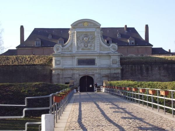
What makes the citadel special is that it is not only technically significant but also visually elegant. Its geometric form, wide moats, robust bastions, and open green surroundings make it feel like a fortress designed by someone who understood both defense and urban order. Even if you are not deeply interested in military history, the citadel is compelling because of how it connects architecture, public space, and the natural environment. It is both a monument and a park-like setting, which gives it a very different feeling from densely built old-town landmarks.
One little-known fact is that the Citadel of Lille is sometimes referred to as the "queen of citadels" because of its importance in Vauban's defensive system. Another detail many visitors miss is how well the structure fits into the modern city. Although originally conceived for warfare, the citadel now helps define a recreational and cultural zone where walking, cycling, family outings, and visits to nearby attractions all take place. That transformation from military stronghold to civic landmark is part of what makes the site interesting today.
The citadel also helps visitors understand Lille's broader history. The city sat near contested borders for centuries, so fortifications were more than symbolic; they were necessary tools of survival and control. Standing at the citadel, you can sense the strategic value of the location and see how a military engineer like Vauban thought about terrain, sightlines, and access. For architecture lovers, history enthusiasts, and casual walkers alike, it is one of Lille's most rewarding destinations.
Getting there is simple by foot, bicycle, or local transport. If you are staying in central Lille, a walk to the citadel is pleasant and reveals how the city's layout changes as you move from dense streets to more open green space. Buses and taxis can also bring you close, but many visitors prefer to use the approach as part of a longer stroll.
Because the citadel is surrounded by parks and walking routes, it works especially well as part of a relaxed day outdoors. You can combine it with the nearby zoo, river paths, or other west-side attractions if you want to make the most of the area.
If you are interested in military history, read a little about Vauban before visiting. His work shaped many French fortifications, and understanding his methods makes the citadel much more meaningful.
Visit in good weather if you want to enjoy the outdoor environment fully. The site is enjoyable year-round, but clear conditions make the geometry and scale easier to appreciate.
Bring comfortable shoes or use a bicycle if you plan to cover more of the surrounding area. The citadel fits naturally into an active day in Lille and is especially pleasant for travelers who enjoy a mix of history and open-air walking.
Discover more hidden gems you might love.
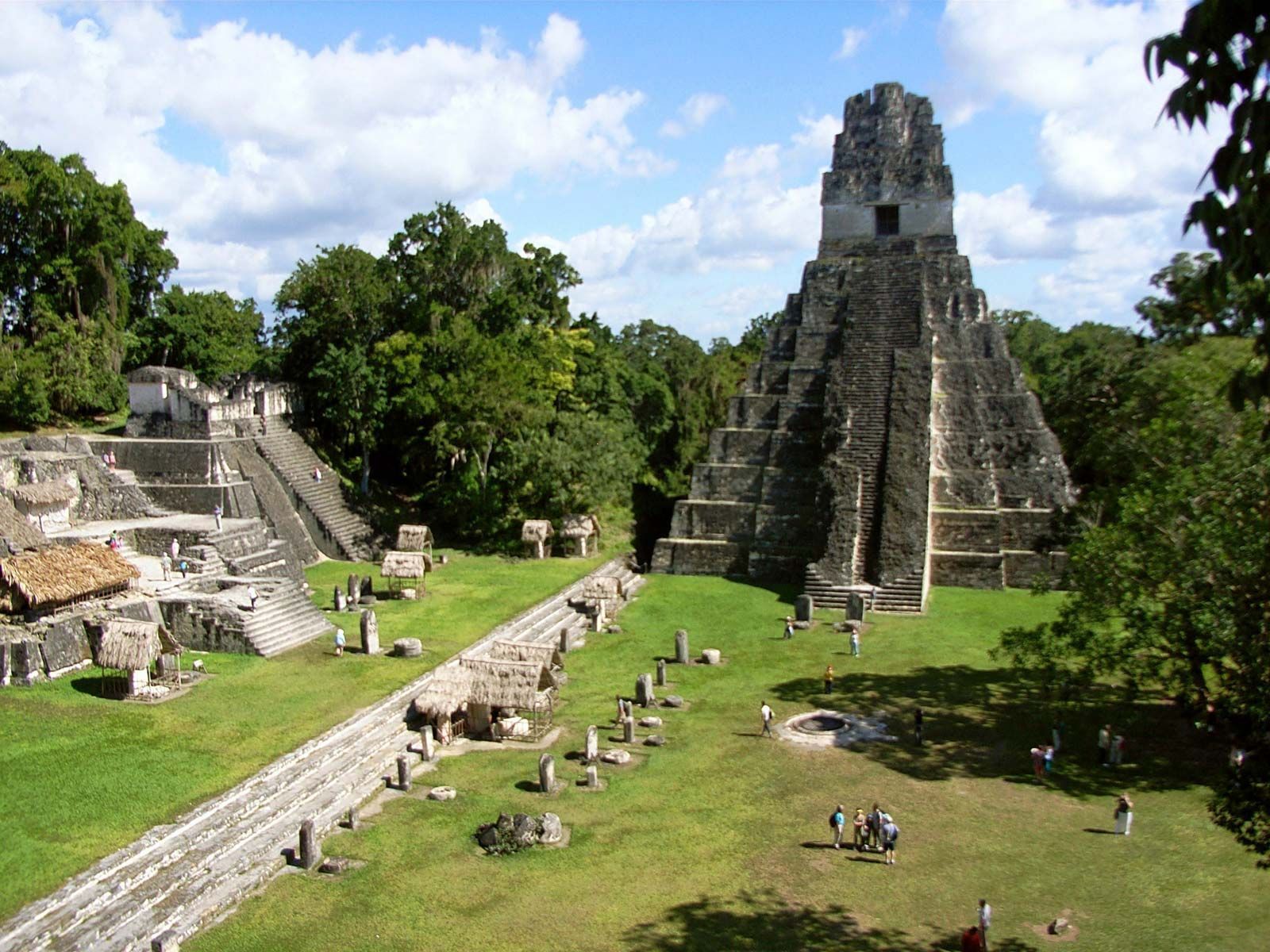
Petén
## Description Tikal is one of the most important archaeological sites of the ancient Maya civilization, located within the dense lowland rainforests of Petén, Guatemala. The city’s towering limestone pyramids and plazas emerge above the jungle canopy, offering dramatic skyline views and a palpable sense of antiquity. During its Classic period, Tikal was a major political and ceremonial center; excavated palaces, stelae and ballcourts tell stories of dynasties, calendrical knowledge and cosmology. Visitors to Tikal are rewarded by a blend of monumental architecture and biodiverse rainforest. The temples and palaces rise through the tree canopy, so that from the tops of several structures you can peer over treetops to see other pyramids peeking through the foliage. This interplay between built environment and ecology is central to Tikal’s power: the jungle both conceals and reveals the city, a dramatic reminder of centuries of abandonment and recovery. Tikal’s primary plaza, monumental ballcourts, and the iconic Temple IV and Temple II complexes preserve stelae with carved inscriptions, verifiable sequences of rulers and artistic programs that speak to the city’s political sophistication. Archaeological work also reveals complex water-management features, reservoirs and causeways that allowed the city to sustain a significant population despite a seasonal tropical climate. Walking among Tikal’s temples at sunrise — when the jungle stirs and howler monkeys call — is an evocative way to connect with a complex culture of architecture, ritual and astronomy. Early morning light transforms the stone into warm tones and dramatically silhouettes the temple profiles against the rising sun, making sunrise a photographer’s favorite. Guides can point out hieroglyphic inscriptions, sacred alignments and the role of celestial observation in Maya ritual life. ## Location Tikal National Park is in Guatemala’s northern Petén department. The site is reachable via a short flight to Flores (Mundo Maya International Airport, FLV) or by road from Flores town, which serves as the usual visitor base. Most visitors use Flores as a staging point and arrange shuttle transfers, guided tours, or independent day trips to the park. ## Tips - **Arrive at dawn for temples and wildlife:** Early mornings provide cooler light, bird activity and quieter conditions before larger tour groups arrive. Dawn visits also let you catch the moment when the jungle wakes up. - **Hire a knowledgeable guide:** Licensed local guides provide historical context, translate glyphs and explain how architecture relates to Maya cosmology — essential for getting more from the site. - **Bring insect repellent and sun protection:** The lowland rainforest environment includes biting insects and strong sunlight in exposed plazas. Lightweight long sleeves and repellent are useful. - **Plan logistics from Flores:** Book shuttle transfers or organized tours in advance during high season, and consider staying overnight near the site for sunset or sunrise experiences. - **Support responsible tourism:** Choose certified guides and operators that follow park rules and contribute to local community economies. ## Conclusion Tikal is both a monumental archaeological treasure and a living jungle experience: temples puncturing the canopy, dawn rituals and carved monuments make it an essential site for understanding Maya civilization. For travelers seeking a mix of natural soundscapes, wildlife encounters and a deep cultural history, Tikal offers an immersive and emotionally resonant experience. ## FAQ - **Q: How long should I spend at Tikal?** A: A full day is ideal to cover the main plazas, climb at least one temple for panoramic views, and explore the northern and central complexes. Two days allow for a slower pace, birding and visiting lesser-known complexes. - **Q: Can visitors climb the temples at Tikal?** A: Access to climbable areas varies — some temples allow limited ascent to designated viewpoints while others are closed to protect fragile structures. Follow current park rules and signage. - **Q: What wildlife might I see at Tikal?** A: Expect to see howler monkeys, toucans, parrots, motmots and a range of tropical birds; early morning is best for birdwatching and animal activity. - **Q: Is it safe for solo travelers and families?** A: The site is generally safe during daylight hours. Follow standard travel precautions: use licensed guides, secure belongings, carry water and avoid isolated areas after dark. - **Q: Are there accommodations near the park?**n+ A: Flores and nearby villages offer a range of lodgings from budget hostels to mid-range hotels; staying in Flores provides easy access to flights and transportation. ## Links - [Tikal — Wikipedia](https://en.wikipedia.org/wiki/Tikal)
GemVoyage Team • World
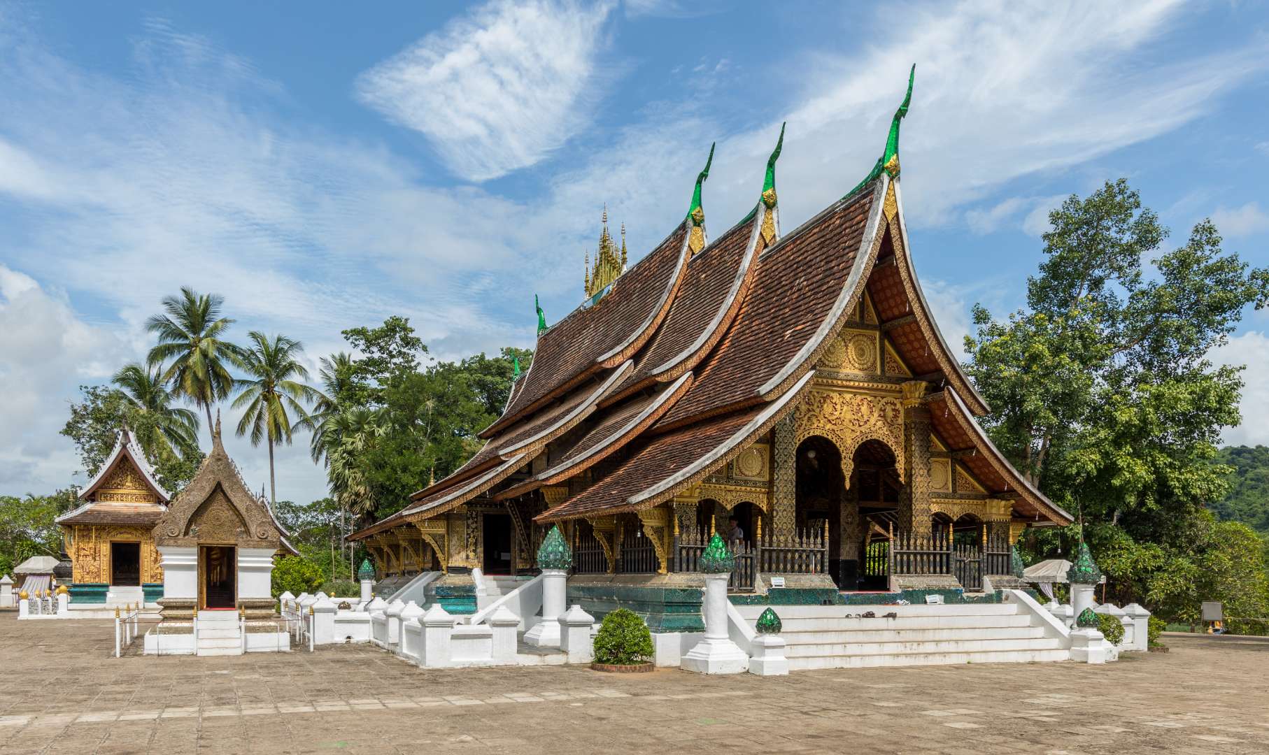
Laos
## Description Wat Xieng Thong, often referred to as the “Temple of the Golden City,” is one of the most revered and architecturally significant Buddhist temples in Laos. Located in the UNESCO World Heritage city of Luang Prabang, this 16th-century temple is a masterpiece of traditional Lao art and religious devotion. Built in 1560 by King Setthathirath, Wat Xieng Thong served as a royal temple and played a central role in religious ceremonies, coronations, and cultural festivals. The temple complex features over twenty structures, including shrines, pavilions, and monks’ quarters. Its centerpiece is the sim (main sanctuary), known for its sweeping multi-tiered roof that nearly touches the ground—a hallmark of classic Luang Prabang style. The rear façade of the sim is adorned with a stunning mosaic of the “Tree of Life,” a symbolic depiction of spiritual growth and harmony. Inside, gold stenciling on black lacquered walls illustrates scenes from Buddhist cosmology and the legendary life of King Chanthaphanith. A little-known fact: Wat Xieng Thong was spared during the sacking of Luang Prabang in 1887 by the Black Flag Haw. The invading leader, Deo Van Tri, had studied at the temple as a monk and chose to use it as his headquarters rather than destroy it. Another unique feature is the temple’s funerary carriage house, which contains an elaborate royal funeral chariot and urns used in cremation ceremonies for members of the royal family. ## Location Wat Xieng Thong is located in **Laos**, in the **Luang Prabang Province**, within the city of **Luang Prabang**. It sits at the northern tip of the peninsula formed by the Mekong and Nam Khan rivers, offering scenic views and a peaceful atmosphere. ### How to Get There - **By Foot**: If you're staying in central Luang Prabang, the temple is easily accessible by walking along the riverfront or through the old town. - **By Bicycle**: Renting a bike is a popular way to explore the city and reach Wat Xieng Thong. - **By Tuk-Tuk**: Local tuk-tuks can take you directly to the temple entrance from anywhere in town. - **By Boat**: Some river tours include a stop at the temple, offering a unique approach from the Mekong. Its location near other major attractions makes it an ideal starting point for a day of cultural exploration. ## Tips - **Visit Early or Late**: Morning and late afternoon offer softer light for photography and fewer crowds. - **Dress Modestly**: As with all religious sites in Laos, shoulders and knees should be covered. Scarves or sarongs are often available at the entrance. - **Take Your Time**: The temple complex is rich in detail. Allocate at least an hour to explore the sim, chapels, and surrounding gardens. - **Hire a Guide**: A local guide can provide deeper insights into the temple’s history, symbolism, and architecture. - **Respect the Space**: Be quiet and respectful, especially when monks are present or prayers are taking place. - **Check for Festivals**: Wat Xieng Thong hosts several annual religious events, including Pi Mai (Lao New Year), which features traditional rituals and processions. ## Conclusion Wat Xieng Thong is a cultural and spiritual gem in Luang Prabang, showcasing the elegance of Lao architecture and the depth of its Buddhist traditions. With its rich history, artistic beauty, and tranquil setting, it offers a profound and memorable experience for visitors. ## FAQ **1. What are the opening hours of Wat Xieng Thong?** The temple is open daily from 8:00 AM to 5:00 PM. **2. Is there an entrance fee?** Yes, the entrance fee is typically around 20,000 Kip per person. **3. Can non-Buddhists visit the temple?** Yes, Wat Xieng Thong is open to all visitors, regardless of religious background. **4. Is photography allowed inside the temple?** Photography is allowed in most areas, but flash and tripods are discouraged. Always be respectful. **5. Are there guided tours available?** Yes, local guides can be hired in Luang Prabang or at the temple entrance. **6. Is the temple wheelchair accessible?** Some areas may be difficult to access due to steps and uneven ground, but the main courtyard is relatively flat. ## Links - [Wat Xieng Thong – Wikipedia Overview](https://en.wikipedia.org/wiki/Wat_Xieng_Thong)
GemVoyage Team • World
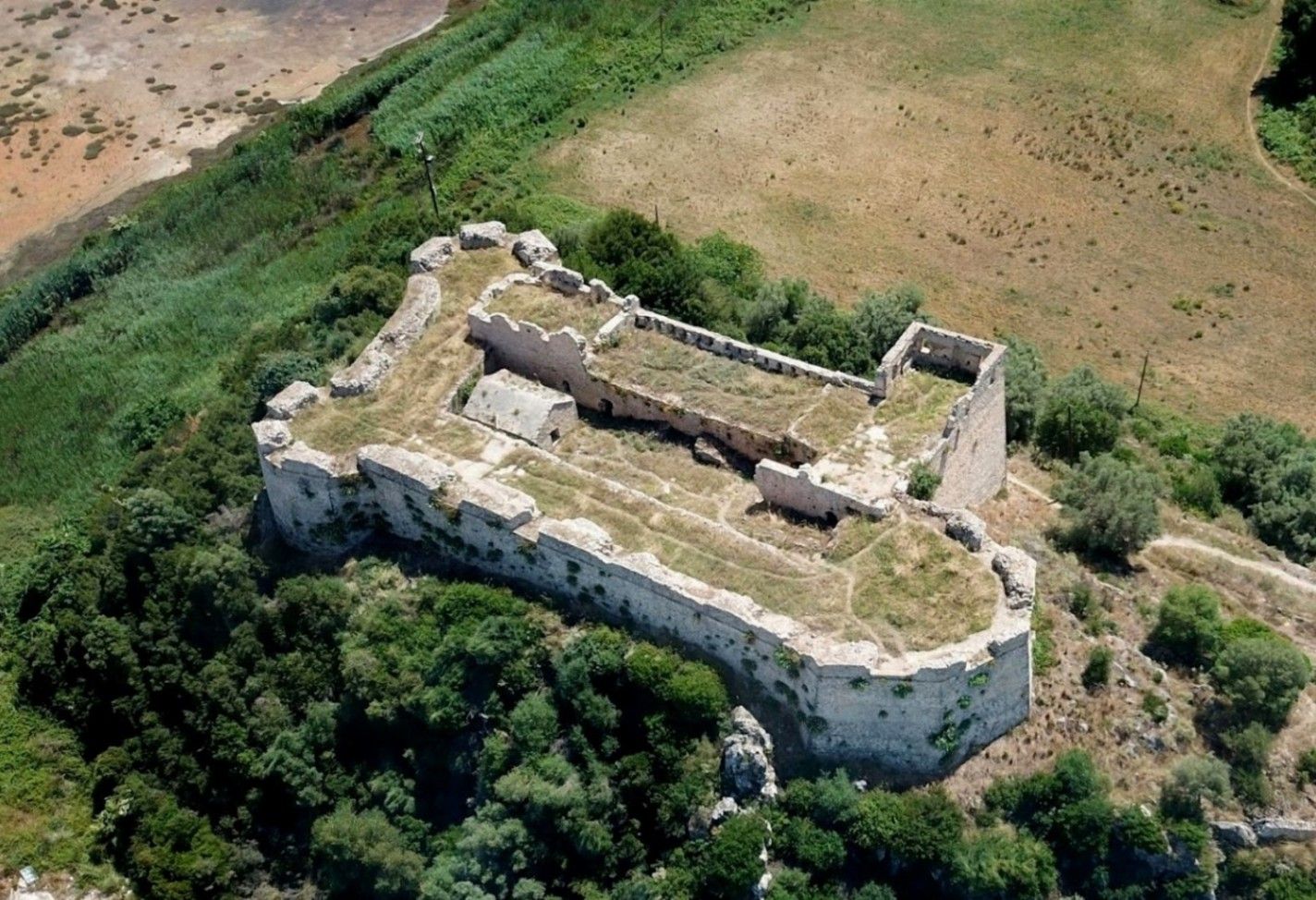
Griva
## Description **Griva Castle** (Κάστρο Γρίβα) is a lesser-known but historically significant fortress perched on a ridge in the region of Central Greece. Unlike Greece’s major medieval castles that attract heavy tourism, Griva Castle stands out for its **raw ruins, unfiltered atmosphere, and panoramic vantage point** over the surrounding mountains and valleys. The site is largely untouched by large-scale restoration efforts, which preserves an authenticity that appeals to explorers, hikers, and history enthusiasts seeking off-the-beaten-path destinations. The castle’s origins date back to the **Ottoman period**, when the structure served as a fortified outpost controlling local routes and offering surveillance over the strategic landscape. Its position was not chosen for grandeur but for **tactical visibility**; from the top of the hill, occupants could observe movements across the region long before they reached nearby settlements. Today, visitors can still walk along the remnants of its stone walls, towers, and defensive perimeters, all while imagining the military operations that once shaped the area. A little-known fact is that the castle area was later used during the **Greek War of Independence**, serving as a refuge and observation point for local fighters resisting Ottoman rule. Another interesting detail is that small-scale excavations have revealed architectural traces suggesting earlier defensive uses, which may predate the Ottoman era. What sets Griva Castle apart is the **simplicity of the experience**. There are no curated exhibitions, no ticket booths, and no commercial vendors. Instead, you step into a quiet, windswept landscape that has retained its historic atmosphere. The lack of crowds makes it ideal for slow-paced exploration, photography, and reflection. With clear weather, the views are expansive, capturing rural settlements, forested hillsides, and rolling terrain that highlight the natural beauty of central Greece. ## Location **Country:** Greece **Region:** Central Greece (Sterea Ellada) **Nearest Town:** Griva or surrounding villages depending on the specific approach The castle sits atop a hill overlooking the local countryside, accessible through rural roads and small village paths. ### How to Get There * **By car:** * The most practical option. Rural roads lead to the village area, from which a short uphill walk brings you to the castle ruins. A standard vehicle is usually sufficient, but some paths may be uneven. * **By bus:** * Limited. Regional buses connect nearby towns, but reaching the castle itself generally requires private transport. * **On foot:** * Hiking paths from the village allow visitors to reach the castle in about 15–25 minutes depending on the route chosen. * **By guided tour:** * Occasional historical or hiking groups include the site, but these are not frequent. ## Tips * **Wear proper footwear:** The terrain is rocky, uneven, and sometimes slippery after rain. * **Visit during daylight:** The area has no lighting, and navigating the ruins after sunset is unsafe. * **Bring water and snacks:** There are no facilities near the castle. * **Check the weather:** Clear skies enhance the views significantly and make the hike easier. * **Combine the visit with nearby villages:** Traditional tavernas in surrounding settlements are ideal for a post-hike meal. * **Photography enthusiasts should visit during golden hour:** The light over the surrounding hills is excellent. ## Conclusion Griva Castle is a quiet, rugged, and historically rich destination that rewards visitors willing to venture beyond mainstream tourist circuits. Its ruins, elevated position, and connection to regional history make it a compelling stop for those seeking authentic Greek landscapes and immersive outdoor exploration. ## FAQ **1. Is there an entrance fee?** No. The site is freely accessible to visitors. **2. Are the ruins safe to explore?** Generally yes, but caution is essential due to uneven paths and the absence of barriers. **3. How long does the visit take?** Most visitors spend **45 minutes to 1.5 hours** depending on hiking time and interest. **4. Is it suitable for children?** Only with supervision. Some sections have steep drops and loose stones. **5. Are guided tours available?** Occasionally, especially by local history or hiking groups, but not regularly. **6. What is the best time of year to visit?** Spring and early autumn offer comfortable temperatures and clear views. ## Links * [Greek tourism information](https://visitgreece.gr)
GemVoyage Team • World

Manchester
## Description The Quays is one of Manchester’s most dynamic and visually striking waterfront areas, known for its blend of modern architecture, cultural landmarks, and leisure spaces. Once part of the historic Manchester Docks, this area has been completely transformed into a contemporary district that reflects the city’s industrial past while embracing innovation and creativity. Today, The Quays is a popular destination for both locals and visitors, offering museums, media hubs, restaurants, and scenic walking routes along the water. What makes The Quays unique is its successful regeneration story. Formerly an active dock system that played a vital role in Britain’s industrial trade, the area fell into decline in the late 20th century before being reimagined as a cultural and media center. A little-known fact is that the docks here were once among the busiest inland ports in the world. Another interesting detail is that The Quays is home to MediaCityUK, where major broadcasters operate live studios, allowing visitors to see television and radio production happening in real time. With iconic attractions such as The Lowry arts center and the Imperial War Museum North, The Quays offers a balanced mix of history, culture, and modern urban life. ## Location The Quays is located in **England**, in the **Greater Manchester** region, within the city of **Manchester**, primarily spanning the Salford Quays area. It lies just west of Manchester city center, along the Manchester Ship Canal. Getting to The Quays is easy and convenient. The Metrolink tram system provides direct access via stops such as **MediaCityUK** and **Salford Quays**, connecting the area to Manchester Piccadilly and other key parts of the city. Several bus routes also serve the area. For those arriving by car, parking is available at various nearby facilities, though public transport is often the most efficient option. ## Tips * Wear comfortable shoes, as the waterfront paths are ideal for walking and exploring the area on foot. * Visit in the late afternoon or evening to enjoy reflections on the water and vibrant nightlife. * Check event schedules at The Lowry and MediaCityUK, as performances and live broadcasts are frequent. * Combine your visit with a museum stop, especially the Imperial War Museum North, which offers free entry. * Bring a light jacket, as the waterfront can feel cooler and windier than the city center. * Photography enthusiasts will appreciate the modern skyline and waterside views, especially at sunset. ## Conclusion The Quays is a standout example of Manchester’s reinvention, transforming historic docks into a lively cultural and entertainment district. Its mix of museums, media, dining, and scenic walks makes it an essential stop for anyone exploring the city. ## FAQ **Is The Quays suitable for families?** Yes, the area is family-friendly, with open spaces, museums, and regular events suitable for all ages. **How much time should I spend at The Quays?** Most visitors spend between two and four hours, depending on activities and attractions visited. **Are there free attractions at The Quays?** Yes, attractions like the Imperial War Museum North offer free entry. **Is The Quays accessible for people with limited mobility?** Yes, the area is modern and generally well equipped with step-free access and wide pathways. **Can I eat and drink at The Quays?** Absolutely. The area offers a wide range of cafés, bars, and restaurants with waterfront views. ## Links * [The Quays Official Website](https://www.thequays.org.uk)
GemVoyage Team • World
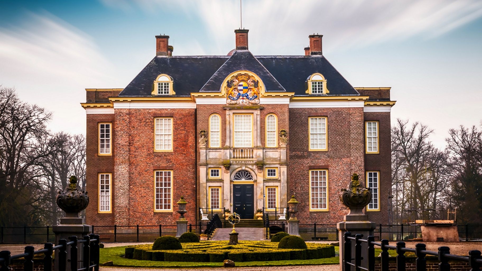
Gelderland
## Description **Middachten Castle (Kasteel Middachten)** is one of the most refined and best-preserved aristocratic estates in the Netherlands, offering visitors a rare glimpse into centuries of noble life largely untouched by modern intervention. Unlike many Dutch castles that were heavily altered, rebuilt, or converted into museums with contemporary reinterpretations, Middachten stands out for its **remarkable historical continuity**. The castle remains closely tied to the noble family that has owned it for generations, and this continuity is clearly reflected in its interiors, collections, and surrounding landscape. The current castle dates mainly from the **17th century**, though the estate itself has medieval origins. Inside, visitors encounter richly furnished rooms with original furniture, tapestries, porcelain, silverware, and paintings accumulated over hundreds of years. Rather than presenting history through reconstructed scenes, Middachten preserves an authentic atmosphere, giving the impression that its residents have only temporarily stepped away. This sense of intimacy and realism sets it apart from more theatrical castle museums. One of Middachten’s most distinctive features is its **formal garden complex**, which combines Dutch, French, and English landscaping traditions. Designed and redesigned over several centuries, the gardens include symmetrical parterres, canals, wooded paths, and open lawns that visually extend the castle into the surrounding countryside. A lesser-known fact is that the gardens still follow **historical planting schemes**, with seasonal flower selections based on archival records. Another interesting detail is that Middachten was never sold to the state; it remains privately owned, which explains its carefully controlled access and limited visiting periods. Middachten Castle is not about spectacle or scale. Its strength lies in authenticity, refinement, and the quiet authority of a place that never needed reinvention to stay relevant. ## Location **Country:** Netherlands **Province:** Gelderland **Village:** De Steeg **Region:** Eastern Netherlands (near Arnhem) Middachten Castle is situated on the edge of the **Veluwezoom**, a scenic area known for forests, rolling hills, and historic estates. Its rural setting enhances the experience, creating a sense of distance from urban life despite being well connected. ### How to Get There * **By train:** * Take a train to **Dieren Station**. From there, the castle is approximately a 20–25 minute walk or a short bicycle ride. * **By bicycle:** * Easily accessible via regional cycling routes, making it ideal for visitors exploring Gelderland by bike. * **By car:** * Parking is available near the estate. Driving is the most practical option for visitors with limited time. * **By bus:** * Local bus services operate between Arnhem, Dieren, and nearby villages, though schedules may be limited. ## Tips * **Check opening periods carefully:** The castle interior is only open during specific months and guided visits. * **Join a guided tour:** Access to the interior is typically guided, and tours provide essential historical context. * **Allow time for the gardens:** The gardens are as important as the castle itself and deserve at least an hour. * **Visit in spring or early summer:** This is when the gardens are at their most vibrant. * **Respect the setting:** Photography inside may be restricted due to preservation concerns. * **Combine with nature walks:** The nearby Veluwezoom area offers excellent hiking opportunities. ## Conclusion Middachten Castle is a refined and quietly powerful example of Dutch aristocratic heritage. Its preserved interiors, historically accurate gardens, and private continuity make it an exceptional destination for visitors who value authenticity over grandeur. ## FAQ **1. Is Middachten Castle a museum?** It functions as a historic house open to the public on a limited basis rather than a conventional museum. **2. Can you visit the castle without a guided tour?** Interior visits are usually guided only; the gardens can often be explored independently. **3. How long should I plan for a visit?** Plan **2 to 3 hours**, including the castle interior and gardens. **4. Is the castle suitable for children?** Yes, though it is best suited for older children with an interest in history. **5. Is Middachten accessible year-round?** No, opening times are seasonal and limited, especially for the interior. **6. Can events be held at the castle?** The estate occasionally hosts cultural events, but private use is highly restricted. ## Links * [Official Middachten Castle website](https://www.middachten.nl)
GemVoyage Team • World
Rome
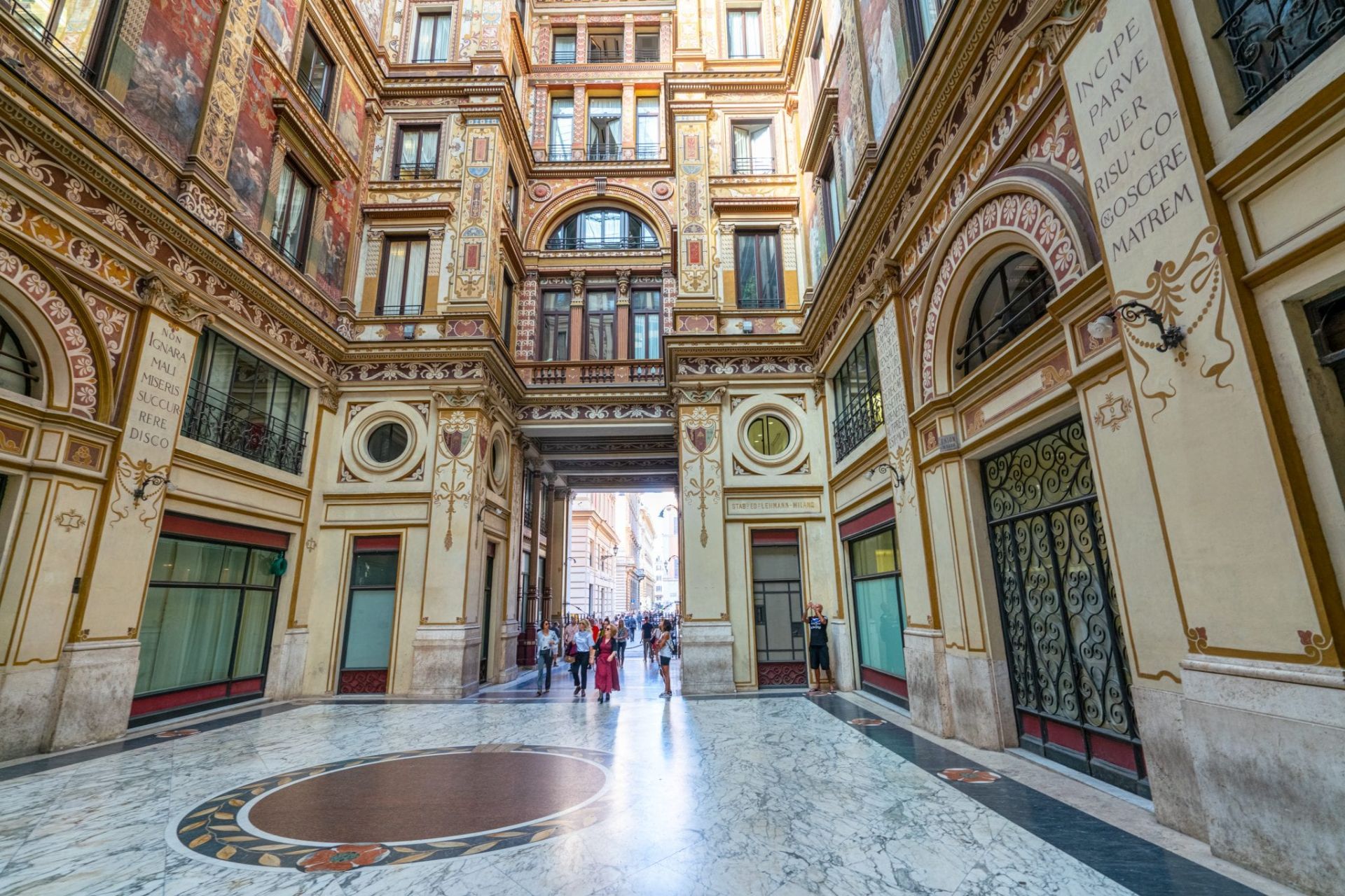
## Description Galleria Sciarra is a discreet Art Nouveau enclave tucked a short walk from Rome’s Trevi Fountain, known for its intricate frescoes, ornate stuccowork and an intimate central courtyard that together form a jewel-like interior. Though modest in scale, the gallery’s decorative program is dense with allegorical figures, botanical motifs and stylized ornamentation that exemplify early twentieth-century design. For visitors who value detail and a quieter pace, the gallery rewards careful looking: painted friezes, subtle color harmonies and small sculptural details reveal layers of craftsmanship. Far from being merely decorative, Galleria Sciarra is a social and architectural statement from an era when private commissions and decorative precincts asserted cultural and civic identity. The gallery’s proportions, the rhythm of its arches, and its palette create a sense of intimacy unusual among Rome’s grand civic monuments. Because it is often bypassed by tourists hurrying between major sites, the gallery feels like a discovery—an easily accessible moment of calm where light, texture and ornament invite slow observation. Photographers, architects and historians are often drawn to the gallery’s scale and surface treatment. The interplay of natural light in the courtyard emphasizes subtle pigments and brushwork, while the ornamental language provides insights into Art Nouveau’s local adaptation in Italy. Visitors who slow down can spot small signatures, painterly corrections and conservation interventions that tell a story about the building’s use and care. Conservation and nearby amenities: the gallery’s delicate finishes mean conservation is ongoing; look for small signs of recent restoration and avoid touching surfaces. After a visit, nearby cafes and gelaterias offer pleasant spots to review details and compare notes — a slow coffee near the Trevi area pairs well with a reflective pause after the gallery’s quiet intensity. ## Location Galleria Sciarra sits just off Via del Corso and the Trevi area, making it an easy detour from Rome’s busiest attractions. It is typically reached on foot from central squares such as Piazza Venezia or the Trevi Fountain, and its tucked-away position often makes it feel like a local discovery even when following a map. Getting there: walking is the most rewarding way to reach the gallery; its central location means it is close to many historic routes. Public transport options to nearby stations are plentiful, but walking from the nearest metro stop provides the best sense of urban context. ## Tips - Visit during daylight: natural light in the courtyard enhances the frescoes and reveals subtle textures. - Move slowly and look closely: the gallery rewards scrutiny—small details and painterly touches are best appreciated up close. - Respect its mixed use: parts of the building may be private offices or residences, so keep voices low and follow signage. - Photography is generally allowed for personal use without flash; avoid tripods during busy times and respect any posted restrictions. - Combine the visit with nearby sites: the Trevi Fountain, Via del Corso and Piazza Venezia are all a short walk away, making it easy to add the gallery to a half-day itinerary. ## Conclusion Galleria Sciarra is a refined, intimate stop for travelers who appreciate decorative arts and the quieter moments of Rome’s architectural fabric. Its compact scale and extraordinary surface detail make it a perfect complement to the city's larger monuments — a short visit that can leave a lasting impression for those who value craft and subtlety. ## FAQ Q: Is Galleria Sciarra open to the public? A: Yes—public access is generally available during daytime hours, but portions of the building may be private. Check local signs or cultural listings for current access and opening times. Q: Is photography allowed inside the gallery? A: For most personal, non-commercial photography, yes; avoid flash to protect pigments and respect any signage indicating restricted areas. Q: How long does a visit typically take? A: Visitors often spend 10–30 minutes depending on interest; those focused on decorative details or photography may linger longer. Q: Is there an admission fee? A: Access is usually free, though special events, exhibitions or guided visits may have a charge. Verify current conditions with local cultural resources. Q: Are guided tours available that include Galleria Sciarra? A: Yes—art-history walks and guided city tours sometimes include the gallery as a stop. Check schedules with local tour operators for times and languages. ## Links - [Galleria Sciarra Tour](https://colosseumandvaticantours.com/galleria-sciarra-the-jewel-of-art-nouveau-in-rome/)
GemVoyage Team • World

Comments