GemVoyage Team • World
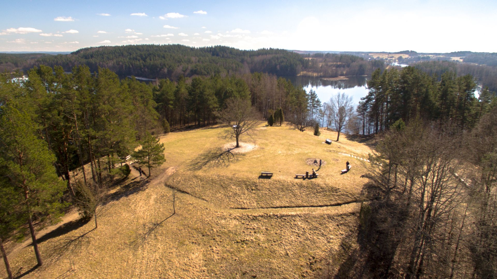
Beyond its scenic value, Ladakalnis carries cultural resonance. Historically a meeting place and, in local traditions, associated with pre-Christian ritual activities, the hill has hosted small folklore events and seasonal gatherings through the centuries. Modest archaeological traces nearby suggest long-term human use of the area, while modern conservation efforts keep the trails accessible and the ecosystem intact. Visitors come for sunrise and sunset views, birdwatching, and gentle hikes that do not require advanced equipment but repay visitors with memorable vistas.
Access is easiest by car from Ignalina or nearby towns; local roads and signage lead to modest parking areas close to the trailhead. Public transport options may include regional buses to Ignalina, after which a short taxi ride or arranged shuttle can bring you to the site. Because the area is rural, plan transfers in advance if you do not have a private vehicle.
Discover more hidden gems you might love.

Socotra
## Description Socotra Island feels like a fragment of another planet — a remote, windswept archipelago in the northwest Indian Ocean whose flora and landscapes defy easy comparison. Part of Yemen’s Socotra Archipelago, the island is famed for its unique biodiversity: roughly one-third of its plant species are endemic, meaning they occur nowhere else on Earth. The emblematic dragon’s blood tree (Dracaena cinnabari) with its umbrella-like silhouette and deep red sap has become a symbol of Socotra’s otherworldly charm. Across the island, landscapes alternate between bizarre limestone plateaus, dramatic sea cliffs, windswept sand flats and pristine white-sand beaches framed by coral reefs. The experience of Socotra is defined by its isolation. Thousands of years of relative climatic stability have allowed life to evolve along separate lines, producing a cast of plants and small reptiles adapted to arid conditions and shallow soils. Visitors remark on the sculptural shapes and strange textures of the vegetation: bulbous succulents, twisted bottle trees, and dense thorny thickets that host endemic birds and invertebrates. This is a place for slow observation — botanizing on rock-strewn plateaus, watching seabirds along cliffs, and learning how local communities have adapted pastoral and fishing traditions to the island’s rhythms. Beyond flora and fauna, Socotra offers an immersive cultural layer. The island’s towns and villages, led by the main hub of Hadibo, display a traditional way of life that blends Bedouin pastoralism with fishing and small-scale commerce. Over the past decade eco-tourism has grown carefully: small guesthouses and locally guided tours emphasize conservation and community benefit. For the adventurous traveler the island’s remote tracks, sea caves and beaches promise solitude and dramatic light, perfect for landscape photography, contemplative walking and quiet wildlife encounters. ## Location Socotra is located in the northwest Indian Ocean, administratively part of Yemen, lying closer to the Horn of Africa than to the Arabian mainland. The island’s primary settlement and logistical hub is Hadibo (sometimes spelled Hadibu) on the northern coast. Historically, reaching Socotra has required careful planning: flights are limited and schedules change with political and logistical conditions. When available, small charter flights connect Socotra with mainland Yemen and, occasionally, regional hubs; sea access — via carefully arranged boat charters or local vessels — is an alternative for those with flexible timing. Because access can be intermittent, most independent travelers book through experienced operators who handle permits, inter-island travel, and local liaison. Visitors should check visa requirements and entry permits well in advance, and factor in contingency days for travel delays. Once on the island, Hadibo serves as the staging point for day trips inland to the Dixam Plateau, the Hagghier Mountains, and coastal excursions to remote beaches and snorkeling sites. ## Tips - **Check travel advisories and logistics:** Socotra’s access and safety status can change with regional developments. Before planning, consult official travel advisories, contact tour operators, and verify flight or sea schedules. Leave buffer days in your itinerary for unexpected delays. - **Use licensed local guides and operators:** Knowledgeable local guides are essential for navigating rocky tracks, interpreting plant life, and arranging transport to remote sites. Hiring local guide services supports the economy and ensures respectful interaction with communities. - **Respect fragile ecosystems:** Much of Socotra’s ecology is fragile. Stick to established tracks, avoid trampling vegetation, do not remove plants or geological material, and use minimal-impact camping practices. - **Pack for varied conditions:** Inland plateaus and mountains can be hot and dry during the day and chilly at night; coastal winds can be strong. Bring sun protection, sturdy hiking boots, a light windproof layer, and a reusable water bottle with a reliable purification method. - **Plan photography and drone use carefully:** Drones may be restricted to protect wildlife and privacy. Always ask local guides about regulations and cultural sensitivities before using camera equipment. - **Health and safety:** Medical facilities on Socotra are basic. Carry a well-stocked first-aid kit, any personal medications, and consider travel insurance with emergency evacuation coverage. Be up to date on routine vaccinations and check for recommended travel vaccines. - **Support local communities:** Choose guesthouses and guides that employ local staff, buy produce and crafts locally, and respect local dress and customs in villages. ## Conclusion Socotra is a destination for travelers who seek radical otherness and ecological rarity. Its alien plant forms, remote beaches, and quiet villages offer an experience both humbling and exhilarating — a reminder of how geographic isolation shapes life in remarkable ways. Thoughtful visitors who arrive well-prepared will find a landscape rich with photographic opportunities, quiet hiking routes, and meaningful encounters with local people and culture. Above all, Socotra rewards patience: time spent watching a dragon’s blood tree silhouette against the sky, or exploring a limestone plateau at dusk, lingers long after the trip ends. ## FAQ - **Q: Is Socotra safe to visit?** A: Safety and access can vary with regional and political conditions. Check up-to-date government travel advisories, consult experienced operators who run tours to Socotra, and register your travel plans with your embassy when appropriate. - **Q: How long should I spend on Socotra?** A: A well-paced visit typically runs 6–10 days. This allows time to explore the Dixam Plateau, the Hagghier Mountains, coastal beaches and a few village visits without feeling rushed. - **Q: When is the best time to visit Socotra?** A: The most comfortable travel window is during the cooler months, roughly October through April. Monsoon-related weather and hot summer temperatures can make travel more difficult in other months. - **Q: Can I arrange independent travel or do I need a tour operator?** A: Because flights and permits are limited, most travelers use reputable operators who arrange logistics, guides and permits. Independent travel is possible but requires local contacts and contingency planning. - **Q: What should I bring for wildlife and landscape photography?** A: Bring a mid-range zoom lens, a wide-angle for landscapes, a sturdy tripod for low-light work, spare batteries and memory cards, and neutral-density filters for coastal long exposures. - **Q: Are there accommodations and food options on the island?** A: Hadibo has small guesthouses and basic restaurants; expect simple but hearty local meals. For remote camping or multi-day excursions, operators typically supply food and equipment — confirm details beforehand. ## Links - [Socotra — Wikipedia](https://en.wikipedia.org/wiki/Socotra)
GemVoyage Team • World
Seoul
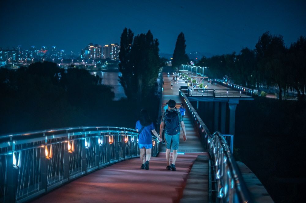
## Description Seonyudo Park is a standout example of urban ecological design: a former water treatment plant reborn as a thoughtfully landscaped public park on an island in the Han River. The designers preserved key elements of the plant—filter basins, machinery platforms, and concrete shells—and repurposed them as botanical displays, reflective ponds and educational spaces. The result is a layered experience where industrial memory and living ecology intersect: walking routes weave through restored filtration beds, shaded groves, themed gardens and interpretive exhibits that explain water purification and habitat restoration. Visitors appreciate Seonyudo for its inviting balance of engineered structure and natural regeneration. The greenhouse and wetland areas host seasonal plantings and migratory birds, while the decks and viewpoints offer long riverside panoramas that are particularly striking at sunset. Beyond the visual appeal, the park operates as a civic classroom: plaques and small exhibits outline the former plant operations and current sustainability initiatives, helping visitors of all ages understand ecological cycles and urban water systems. Seonyudo’s design also makes it a pleasant social space: picnic spots, quiet courtyards and accessible pathways encourage lingering, and occasional cultural events—workshops, guided ecological walks and small performances—lend the park a local community feel. For urban planners, photographers and families alike, Seonyudo Park is a model of how industrial remnants can be transformed into resilient public amenities. ## Location Seonyudo Park sits on Seonyudo Island in the Han River within Mapo-gu, central Seoul. The island is easy to reach by the pedestrian footbridge connecting to the northern riverbank near Dangsan, and public transit options include Seonyudo Station (Line 9) and nearby bus stops. Cyclists frequently access the island via the riverside cycling paths that thread along the Han. Because Seonyudo is integrated into the riverfront network, you can combine a visit with a longer riverside ride or walk that links to adjacent parks and cultural districts. The park’s central location makes it an accessible stop during a day exploring Mapo and the west bank of the Han. ## Tips - Go in late afternoon or early evening for the best light and cooler temperatures, especially in summer. - Rent or bring a bicycle to follow the riverside paths; Seonyudo is well connected to Seoul’s cycling routes. - Take the short interpretive walk through the former filter beds to learn about the site’s history and water treatment processes—signage and occasional guided tours add context. - Pack a picnic or a light snack; while there are small kiosks at times, facilities are limited compared with larger parks. - Watch for seasonal plantings and bird migrations—spring and autumn are especially rewarding for flora and fauna observation. ## Conclusion Seonyudo Park exemplifies how thoughtful design can convert industrial infrastructure into productive green space. It rewards visitors who are curious about urban sustainability, landscape architecture and the layered histories of cities. Whether you are a photographer seeking unique compositions of water and concrete, a family looking for a quiet riverside escape, or a planner studying adaptive reuse, Seonyudo offers a memorable, instructive and restful visit. ## FAQ Q: Is there an entrance fee? A: No. Seonyudo Park is a public park and free to enter, though some seasonal programs or guided workshops may have small fees. Q: Are dogs allowed in the park? A: Dogs are generally allowed but must be kept on a leash and under control; check posted rules for specific zone restrictions. Q: Are there restroom facilities and drinking water? A: Public restrooms and water fountains are available near principal access points, but facilities can be limited—carry water for long summer visits. Q: Can I cycle across the park? A: Cycling routes approach and circle the island; on-site cycling may be restricted in certain pedestrian or ecological zones—dismount where indicated. Q: Is there parking nearby? A: Limited parking is available along nearby roads, but public transit and cycling routes are the preferred ways to reach the island. ## Links - [Seonyudo Park (Wikipedia)](https://en.wikipedia.org/wiki/Seonyudo_Park)
GemVoyage Team • World
Stavanger
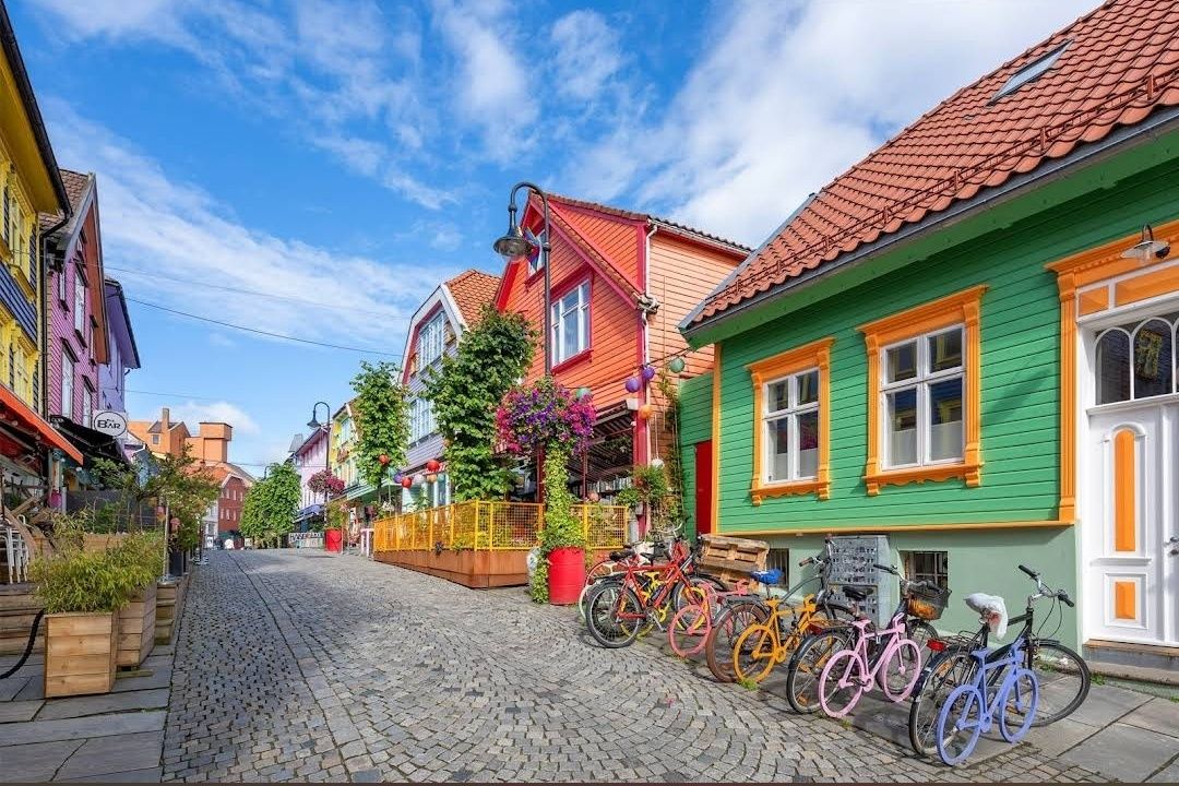
## Description **Fargegaten** stands out as one of Norway’s most visually striking streets, where entire facades burst with vivid hues. This creative transformation turned a once-dull, quiet lane into a lively, Instagram-worthy pedestrian hotspot. What started as a revitalization project has become a beloved urban gem. **Little-known facts**: * The idea originated with a local hairdresser, **Tom Kjørsvik**, who spearheaded the project to breathe life back into the street—work that stretched over four years and required approval from both landlords and the city council. * Some of the color inspirations came from retro aesthetics: the artist **Craig Flannagan**, responsible for choosing the palette, drew from influences like the 1970s TV show *Miami Vice*. --- ## Location Fargegaten is located in **Stavanger**, within the **Rogaland** county of **Norway**—specifically on the eastern stretch of **Øvre Holmegate**, between Kirkegata and Østervåg. ### How to get there * It’s easy to reach on foot from Stavanger’s city centre—just follow signs toward Øvre Holmegate. * You can also hop off at **Bus stop 10** on local sightseeing bus routes, which stop nearby. --- ## Tips * To make the most of your visit, come with your camera ready—Fargegaten is one of the most Instagrammable spots in Stavanger. * The street is pedestrian-only since **2005**, making for a relaxed, car-free experience. * Explore niche boutiques like *Den Syvende Himmel*, *Kjoledamen*, and *Bernina’s sewing shop*. From a barbershop or tattoo parlor to a dress store with handmade silkscreen prints—Fargegaten has something for curious shoppers. * After shopping, treat yourself to local flavors at one of the cozy cafés or bars. It’s a joy to sit and watch the street come alive with color and community. --- ## Conclusion Fargegaten in Stavanger is more than a pretty street—it's a community-driven masterpiece. From a faded, overlooked lane to a radiant display of color and culture, it’s a testament to local creativity, persistence, and transformation. Whether you're snapping photos, exploring boutiques, or simply soaking in the atmosphere, Fargegaten offers a joyful, memorable slice of Stavanger life. --- ## FAQ **1. Why is it called Fargegaten?** “Fargegaten” translates to “The Colour Street,” a nickname earned from its boldly painted façades that made the once-quiet Øvre Holmegate a vivid landmark. **2. Who came up with the idea to paint the street?** A local hairdresser named **Tom Kjørsvik** initiated the project, aiming to revive the neglected street. The transformation spanned over four years, involving landlords, the city council, and artist Craig Flannagan to plan the color scheme. **3. Is Fargegaten suitable for families?** Absolutely—it's pedestrian-friendly, safe, and fun to explore. With boutiques, cafés, and colorful surroundings, it offers a lively but relaxed experience that’s great for all ages. **4. What types of shops can I find there?** Expect niche boutiques, dress shops like *Den Syvende Himmel*, sewing stores like *Bernina*, barbershops, tattoo parlors, and even a store offering handmade silkscreen clothing prints (Kant). **5. Can you drive there?** No—Fargegaten has been a pedestrian-only street since 2005, and additional sections between Skagenkaien and Kirkegata were later closed to cars, making for a safe and pleasant stroll. **6. What's the best time to visit?** Any time during daylight is best—colorful façades stand out beautifully under natural light, making for perfect photo conditions and cheerful ambiance. --- ## Links * [Visit Norway](https://www.visitnorway.com/) * [Fargegaten Information](https://www.visitnorway.com/places-to-go/fjord-norway/the-stavanger-region/listings-stavanger/fargegaten-%C3%98vre-holmegate-the-colourful-street/235310/)
GemVoyage Team • World
Pokhara
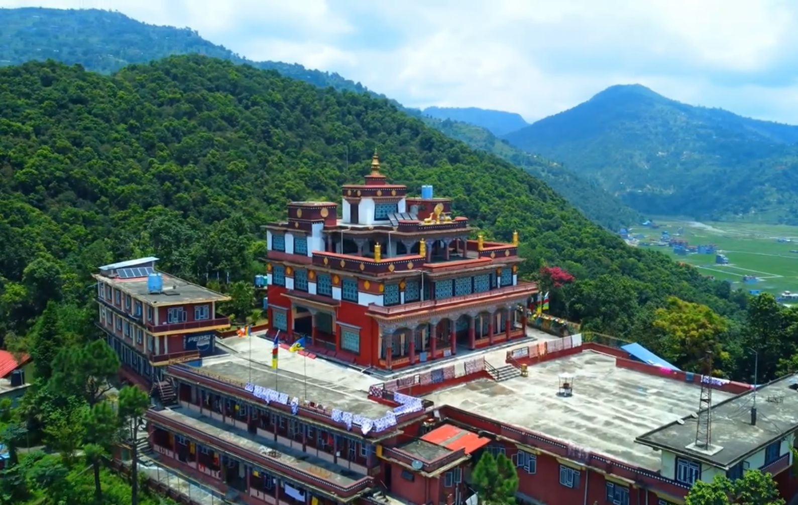
## Description **Matepani Gumba** is a serene Buddhist monastery perched on a quiet hillside in Pokhara, Nepal. It’s one of the city’s lesser-known yet most spiritually rewarding attractions. Built in the 1960s by Tibetan refugees, the monastery belongs to the **Gelug sect of Tibetan Buddhism**, often referred to as the “Yellow Hat” tradition. Its colorful architecture, peaceful ambiance, and panoramic views of Pokhara make it a must-visit for travelers seeking both cultural depth and tranquility. The interior of the monastery is breathtaking. Its main prayer hall is adorned with **intricate murals depicting scenes from Buddhist teachings**, as well as striking statues of Buddha and various deities. During prayer sessions, the air fills with the sound of chanting monks, the beating of drums, and the rhythmic call of long Tibetan horns—a mesmerizing spiritual experience. **Little-known facts**: * The monastery is home to a community of young monks in training. Visitors may often see them playing outside after prayers or diligently studying inside. * Matepani Gumba was strategically built on a hilltop not only for its peaceful isolation but also for its sweeping view of Pokhara Valley, including glimpses of **Phewa Lake** and the **Annapurna mountain range** on clear days. --- ## Location Matepani Gumba is located in **Pokhara**, within the **Gandaki Province** of **Nepal**. It sits atop a hill in the **Matepani neighborhood**, about 5 kilometers northeast of Pokhara’s Lakeside area, the main tourist hub. ### How to get there: * The most convenient way is to take a **taxi** or hire a scooter from Lakeside. The drive takes around 15–20 minutes. * Adventurous travelers can also hike up the hill. The walk is a bit steep but rewarding, as you’ll pass through local neighborhoods and enjoy peaceful surroundings along the way. --- ## Tips * **Attend a prayer session**: If possible, time your visit with the monks’ chanting rituals. These are usually held in the morning or late afternoon, and they offer an unforgettable cultural experience. * **Dress respectfully**: As a place of worship, modest clothing is expected. Remove your shoes before entering the main prayer hall. * **Bring a camera, but be mindful**: The monastery’s colorful murals and views are photogenic, but always ask before photographing monks or ceremonies. * **Combine your visit**: Matepani Gumba pairs well with other cultural sites in Pokhara, such as the World Peace Pagoda or Bindhyabasini Temple. * **Go in the morning**: The air is clear, the light is soft for photos, and you’re more likely to catch monks engaged in prayers. --- ## Conclusion Matepani Gumba is more than just a monastery—it’s a peaceful retreat where spirituality, culture, and nature come together. With its rich Tibetan Buddhist heritage, beautiful murals, and tranquil hilltop setting, it offers visitors a unique chance to step away from Pokhara’s busy streets and experience a different side of the city. Whether you’re drawn by faith, culture, or simply the desire for quiet reflection, Matepani Gumba leaves a lasting impression. --- ## FAQ **1. What is Matepani Gumba known for?** It’s a Tibetan Buddhist monastery famous for its vibrant murals, large statues, and peaceful hilltop location overlooking Pokhara. **2. Can visitors attend ceremonies at the monastery?** Yes, visitors are welcome to observe prayer sessions, but it’s important to remain quiet and respectful during rituals. **3. Is there an entrance fee?** No, entry to Matepani Gumba is generally free, though donations are appreciated to help maintain the monastery. **4. How long should I plan for a visit?** A visit usually takes 1–2 hours, depending on whether you stay for a prayer session or spend time enjoying the views. **5. Is it family-friendly?** Yes, the peaceful atmosphere and open grounds make it suitable for families, though young children should be supervised inside the prayer hall. **6. What’s the best way to reach Matepani Gumba?** The easiest option is by taxi from Lakeside, but walking or riding a scooter are also popular choices for adventurous travelers. --- ## Links * [Pokhara Tourism Board](https://ntb.gov.np/pokhara) * [Lonely Planet – Pokhara](https://www.lonelyplanet.com/nepal/pokhara)
GemVoyage Team • World
Copenhagen
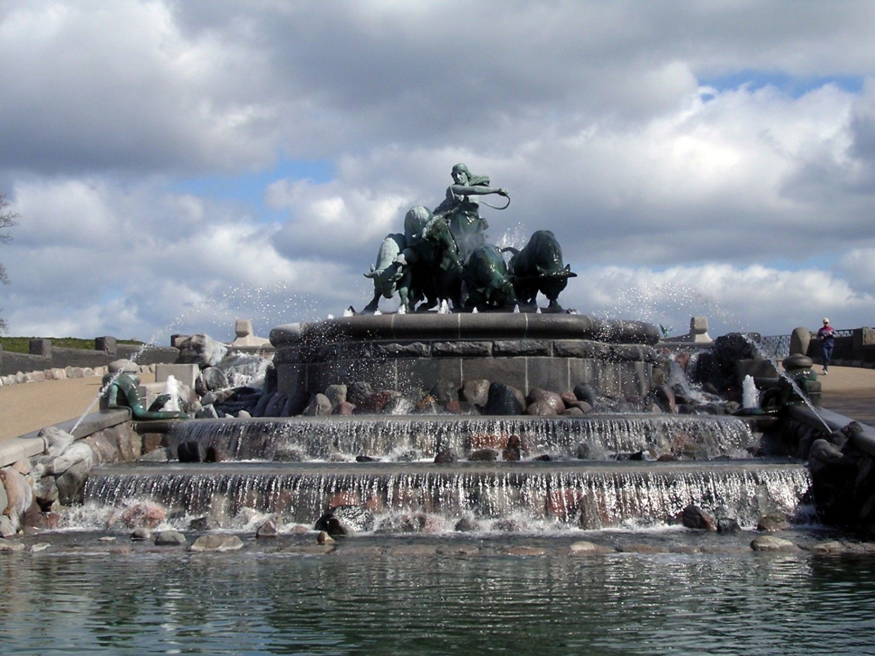
## Description The **Gefion Fountain (Gefionspringvandet)** is one of **Copenhagen’s most iconic landmarks**, combining stunning sculpture, mythological symbolism, and the serene beauty of its waterfront setting. Unveiled in **1908**, the fountain depicts the **Norse goddess Gefion**, a figure from ancient Scandinavian mythology, driving a group of **powerful oxen** as they pull the land that became the island of **Zealand (Sjælland)** — where Copenhagen stands today — from the depths of the sea. Designed by **Danish sculptor Anders Bundgaard**, the fountain is both a **monumental work of art** and a **celebration of Danish legend and identity**. The dynamic bronze figures, set atop a granite basin, capture the dramatic moment of transformation: Gefion’s oxen straining against their harnesses, water surging around them, and the goddess commanding them with divine strength. The story behind the sculpture comes from **Norse mythology**, where Gefion tricks the Swedish king **Gylfi** into granting her as much land as she can plow in one night. Transforming her four sons into oxen, she plows through the earth and casts the land into the sea — forming the island of Zealand. The resulting lake in Sweden, **Lake Vänern**, is said to match Zealand’s shape. What makes the Gefion Fountain unique is not only its **artistic detail and mythological depth** but also its **location** — it sits between **Kastellet Fortress** and **Langelinie Promenade**, surrounded by lush greenery and views of the **harbor** and **The Little Mermaid statue** nearby. The fountain is especially magical when illuminated at night, with the flowing water and shimmering bronze giving it an ethereal glow. A lesser-known fact is that the fountain was originally commissioned by the **Carlsberg Foundation** to celebrate the brewery’s 50th anniversary and was gifted to the city of Copenhagen. Another interesting detail: the granite blocks forming the base came from **Sweden**, a subtle nod to the myth that connects the two lands. ## Location The **Gefion Fountain** is located in **Churchillparken (Churchill Park)** near **Langelinie**, in the **central harbor area of Copenhagen**, **Denmark**. It sits just east of **Amalienborg Palace** and north of the **Kastellet (The Citadel)** fortress. To get there: * **By metro:** Take the **M3 (City Circle Line)** to **Marmorkirken Station**, then walk about **10 minutes** northeast toward the harbor. * **By bus:** Several local buses, including routes **26** and **27**, stop nearby at **Esplanaden**. * **By foot or bike:** The fountain is part of a popular **walking and cycling route** that connects **Amalienborg**, **The Little Mermaid**, and **Kastellet**. * **By car:** Limited parking is available nearby, though walking or cycling is more convenient in this area. ## Tips * **Visit in the morning or late evening:** The light at sunrise and sunset enhances the sculpture’s bronze tones and reflections. * **Combine with nearby landmarks:** The **Little Mermaid**, **Kastellet Fortress**, and **Amalienborg Palace** are all within walking distance. * **Evening illumination:** Visit after dark to see the fountain beautifully lit — a favorite spot for photographers. * **Learn the mythology:** Understanding the legend of Gefion adds depth to your visit; many plaques around the site explain the story. * **Bring a camera:** The fountain’s movement, water effects, and sculptural detail make it a fantastic subject for photos. * **Relax nearby:** The surrounding park offers benches and green spaces perfect for a quiet break during a city walk. * **Visit year-round:** While the fountain operates mainly in warmer months, the sculptures remain accessible and impressive throughout the year. ## Conclusion The **Gefion Fountain** is much more than a beautiful monument — it’s a vivid connection between Denmark’s ancient mythology and its modern identity. With its stunning artistry, powerful symbolism, and scenic harbor location, it perfectly embodies Copenhagen’s blend of **history, legend, and elegance**. Whether you’re tracing the city’s cultural landmarks, enjoying a peaceful stroll through Churchill Park, or exploring Norse mythology, the Gefion Fountain offers a moment of reflection and wonder that captures the timeless spirit of Denmark. ## FAQ **1. What does the Gefion Fountain represent?** It depicts the Norse goddess **Gefion** plowing the land that became the island of **Zealand (Sjælland)**, symbolizing the creation of Denmark’s largest island. **2. Who designed the fountain?** The fountain was created by **Anders Bundgaard**, one of Denmark’s most celebrated sculptors, and unveiled in **1908**. **3. Where is the Gefion Fountain located?** In **Churchillparken**, near **Langelinie Promenade** and **Kastellet Fortress**, in central **Copenhagen**, Denmark. **4. Is it near other attractions?** Yes — it’s just a short walk from **The Little Mermaid**, **Amalienborg Palace**, and the **harborfront**. **5. When does the fountain operate?** The fountain usually runs from **April to October**, depending on weather conditions. The sculptures can be viewed year-round. **6. Is there an entrance fee?** No — visiting the Gefion Fountain is **free of charge**. **7. Can I visit at night?** Yes, and it’s highly recommended. The **evening lighting** creates a beautiful, almost mythical atmosphere. ## Links * [Official Visit Copenhagen – Gefion Fountain](https://www.visitcopenhagen.com/)
GemVoyage Team • World
Beijing
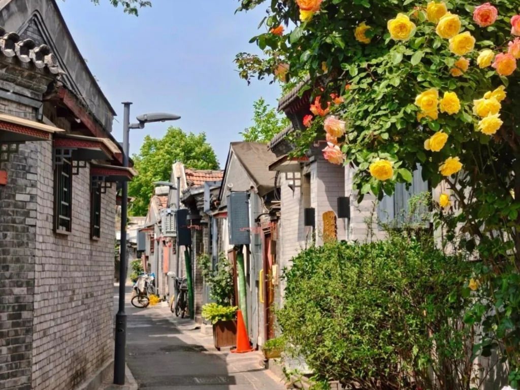
## Description Qinhuangdao Alley Hutongs, as a travel idea, points to one of Beijing’s most rewarding urban experiences: moving through the city’s traditional hutong lanes and seeing how historic residential fabric still shapes everyday life. Hutongs are not grand monuments in the usual sense. They are narrow lanes, courtyard-house networks, and neighborhood corridors that preserve a more intimate view of Beijing than the city’s large avenues and famous landmarks. That is exactly why they remain so compelling. They let visitors step into the scale of older Beijing, where community, domestic life, and street activity sit in close proximity. The appeal of the hutong experience lies in its texture. Instead of one single iconic object, you get layered details: gray brick walls, courtyard entrances, hand-painted signs, hidden cafés, neighborhood shops, bicycles, small temples, and the daily rhythm of residents going about ordinary routines. A lesser-known fact is that hutongs are not just tourist curiosities; they are living urban forms that have survived because they still support local life, even as some areas have changed dramatically. Another overlooked detail is that many of the most interesting hutong walks reveal small architectural differences from lane to lane, including gate styles, courtyard layouts, and adaptations made over time to fit modern use. If you are traveling in Beijing for the first time, hutongs can be one of the most useful experiences you choose because they explain the city in a human-scale way. They show how neighborhoods are organized, how people move, and how history remains present without always announcing itself loudly. Unlike large museums, the hutong district does not ask you to stand still. It invites you to wander, notice, and compare. That makes it especially rewarding for slow travelers, photographers, architecture lovers, and anyone who prefers atmosphere over checklist sightseeing. The name “Qinhuangdao Alley Hutongs” may be used locally or descriptively, but the broader experience belongs firmly to Beijing’s historic center. Rather than approaching it as a single fenced attraction, think of it as a neighborhood exploration. That mindset will help you appreciate it much more fully. ## Location The hutong experience is centered in Beijing Municipality, China, especially in the older districts of Dongcheng and Xicheng where historic lanes remain most visible. Depending on the exact lane or alley you plan to visit, you may be close to landmarks such as Shichahai, Nanluoguxiang, the Bell and Drum Towers, or other traditional neighborhoods. Because hutongs are embedded in the city’s fabric, their location is best understood as a district-level experience rather than a single destination pin. Getting there is usually easiest by subway, followed by a short walk. Beijing’s public transit network is efficient for reaching the historic core, and once you exit the station, the pleasure comes from entering the smaller lanes on foot. Taxis and rideshares are also practical, but traffic can make them slower than the metro during busy hours. If you prefer a more immersive approach, combine subway access with a walking route that allows for detours into side streets. Because the exact lanes can be harder to define than a single monument, it helps to visit with an open itinerary. Choose a starting point in a known hutong district and then let the side alleys guide your exploration. That approach usually produces the most interesting results. ## Tips Walk slowly. Hutongs reward attention to detail, and many of their best moments are found between the obvious sights. Respect private space. These are living neighborhoods, not theme park sets, so it is important to be considerate when taking photos or peering into courtyards. Visit at a comfortable time of day. Morning and late afternoon often feel more pleasant for walking, with softer light and a calmer pace. Combine the walk with food. Small noodle shops, tea spots, and casual eateries can turn a simple stroll into a much richer cultural experience. Do not try to “finish” the hutongs. The value is in wandering a manageable section well, not in covering everything. ## Conclusion The hutongs of Beijing offer one of the most atmospheric ways to understand the city. They are historic, living, and quietly beautiful, with enough variation to reward curiosity at every turn. For travelers who want Beijing beyond its headline monuments, this is an essential experience. ## FAQ ### What is a hutong? A hutong is a traditional Beijing alley or lane, usually linked to courtyard-house neighborhoods. The form reflects older patterns of urban life and remains an important part of the city’s identity. ### Are hutongs still inhabited? Yes. Many hutong areas are still lived in, even though some have been renovated, adapted, or repurposed for commerce and tourism. ### Is this more of a walking experience than a fixed attraction? Exactly. Hutongs are best understood as a walkable neighborhood environment rather than a single enclosed site. ### How long should I spend there? A focused walk might take 1 to 2 hours, but a more rewarding visit can easily stretch longer if you stop for food, tea, or photography. ## Links - [Hutong on Wikipedia](https://en.wikipedia.org/wiki/Hutong) - [Beijing official tourism](https://english.beijing.gov.cn/)
GemVoyage Team • World

Comments