Discover extraordinary places shared by our community of travelers
Tanga
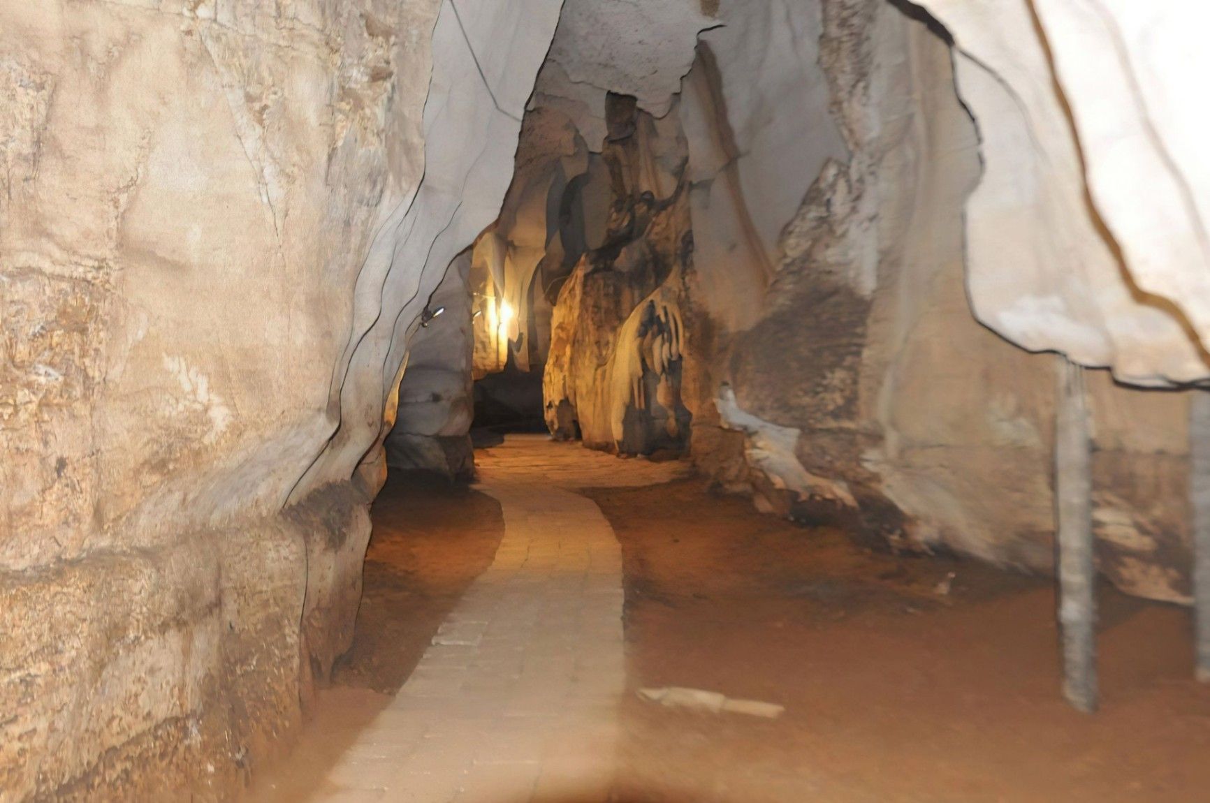
## Description Amboni Caves are among the most fascinating natural attractions in Tanzania, offering visitors a journey into an ancient underground world shaped by time, water, and geology. These limestone caves are believed to be over 150 million years old, making them one of the oldest cave systems in East Africa. With dark chambers, narrow passageways, and dramatic rock formations, Amboni Caves provide a sense of mystery and adventure that contrasts sharply with the nearby coastal landscapes. What makes Amboni Caves truly unique is their combination of natural, cultural, and spiritual significance. The caves are not only a geological marvel but also a site deeply connected to local beliefs and traditions. Many chambers are associated with spiritual practices, and some are still used for traditional rituals by surrounding communities. A little-known fact is that the caves are named after a colonial-era engineer, Amboni, who is believed to have popularized their exploration, although local communities had known and used the caves long before. Another lesser-known detail is that the cave system consists of at least ten interconnected chambers, each with its own name, legend, and distinct rock formations. Visiting Amboni Caves is both an educational and atmospheric experience, offering insight into Tanzania’s natural history as well as its living cultural traditions. ## Location Amboni Caves are located in **Tanzania**, in the **Tanga Region**, near the city of **Tanga**, along the northeastern coast of the country. The caves are situated about 6 kilometers north of Tanga city center, close to the Indian Ocean. Reaching the caves is relatively easy. Visitors can take a taxi or local transport from Tanga, with the journey usually taking 15 to 20 minutes. For travelers coming from other parts of Tanzania, Tanga is accessible by road, train, or domestic flights. Once near the site, a short walk leads to the cave entrance. Hiring a local guide at the site is strongly recommended, as the cave layout can be confusing without assistance. ## Tips * Always visit with a local guide, as the caves are dark, complex, and rich in cultural meaning. * Wear sturdy shoes with good grip, since the cave floors can be slippery and uneven. * Bring a flashlight or headlamp, even if guides provide lighting, for better visibility. * Dress comfortably and be prepared for warm and humid conditions inside the caves. * Respect local customs, as certain areas may be considered sacred. * Visit earlier in the day for a quieter experience and better overall visibility. ## Conclusion Amboni Caves offer a rare opportunity to explore one of Tanzania’s oldest natural formations while learning about the cultural traditions connected to it. With their ancient rock structures, spiritual significance, and sense of adventure, the caves stand out as a unique and rewarding destination near Tanga. ## FAQ **Are Amboni Caves safe to visit?** Yes, they are safe when visited with an experienced local guide who knows the cave layout and conditions. **How long does a visit to Amboni Caves take?** Most guided visits last between 45 minutes and 1.5 hours, depending on the route and interest level. **Is the site suitable for children?** Older children may enjoy the experience, but very young children might find the dark and narrow spaces challenging. **Is there an entrance fee?** Yes, a small entrance fee is usually charged, with additional costs for guided tours. **Can I take photos inside the caves?** Photography is generally allowed, but flash use and certain areas may be restricted, so always ask your guide. ## Links * [Tanzania Tourist Board](https://www.tanzaniatourism.go.tz) * [Tanga Region Information](https://www.tanga.go.tz)
GemVoyage Team • World
Stavanger
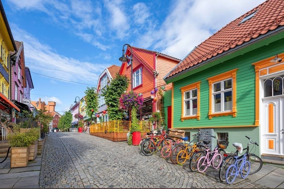
## Description **Fargegaten** stands out as one of Norway’s most visually striking streets, where entire facades burst with vivid hues. This creative transformation turned a once-dull, quiet lane into a lively, Instagram-worthy pedestrian hotspot. What started as a revitalization project has become a beloved urban gem. **Little-known facts**: * The idea originated with a local hairdresser, **Tom Kjørsvik**, who spearheaded the project to breathe life back into the street—work that stretched over four years and required approval from both landlords and the city council. * Some of the color inspirations came from retro aesthetics: the artist **Craig Flannagan**, responsible for choosing the palette, drew from influences like the 1970s TV show *Miami Vice*. --- ## Location Fargegaten is located in **Stavanger**, within the **Rogaland** county of **Norway**—specifically on the eastern stretch of **Øvre Holmegate**, between Kirkegata and Østervåg. ### How to get there * It’s easy to reach on foot from Stavanger’s city centre—just follow signs toward Øvre Holmegate. * You can also hop off at **Bus stop 10** on local sightseeing bus routes, which stop nearby. --- ## Tips * To make the most of your visit, come with your camera ready—Fargegaten is one of the most Instagrammable spots in Stavanger. * The street is pedestrian-only since **2005**, making for a relaxed, car-free experience. * Explore niche boutiques like *Den Syvende Himmel*, *Kjoledamen*, and *Bernina’s sewing shop*. From a barbershop or tattoo parlor to a dress store with handmade silkscreen prints—Fargegaten has something for curious shoppers. * After shopping, treat yourself to local flavors at one of the cozy cafés or bars. It’s a joy to sit and watch the street come alive with color and community. --- ## Conclusion Fargegaten in Stavanger is more than a pretty street—it's a community-driven masterpiece. From a faded, overlooked lane to a radiant display of color and culture, it’s a testament to local creativity, persistence, and transformation. Whether you're snapping photos, exploring boutiques, or simply soaking in the atmosphere, Fargegaten offers a joyful, memorable slice of Stavanger life. --- ## FAQ **1. Why is it called Fargegaten?** “Fargegaten” translates to “The Colour Street,” a nickname earned from its boldly painted façades that made the once-quiet Øvre Holmegate a vivid landmark. **2. Who came up with the idea to paint the street?** A local hairdresser named **Tom Kjørsvik** initiated the project, aiming to revive the neglected street. The transformation spanned over four years, involving landlords, the city council, and artist Craig Flannagan to plan the color scheme. **3. Is Fargegaten suitable for families?** Absolutely—it's pedestrian-friendly, safe, and fun to explore. With boutiques, cafés, and colorful surroundings, it offers a lively but relaxed experience that’s great for all ages. **4. What types of shops can I find there?** Expect niche boutiques, dress shops like *Den Syvende Himmel*, sewing stores like *Bernina*, barbershops, tattoo parlors, and even a store offering handmade silkscreen clothing prints (Kant). **5. Can you drive there?** No—Fargegaten has been a pedestrian-only street since 2005, and additional sections between Skagenkaien and Kirkegata were later closed to cars, making for a safe and pleasant stroll. **6. What's the best time to visit?** Any time during daylight is best—colorful façades stand out beautifully under natural light, making for perfect photo conditions and cheerful ambiance. --- ## Links * [Visit Norway](https://www.visitnorway.com/) * [Fargegaten Information](https://www.visitnorway.com/places-to-go/fjord-norway/the-stavanger-region/listings-stavanger/fargegaten-%C3%98vre-holmegate-the-colourful-street/235310/)
GemVoyage Team • World
Faro
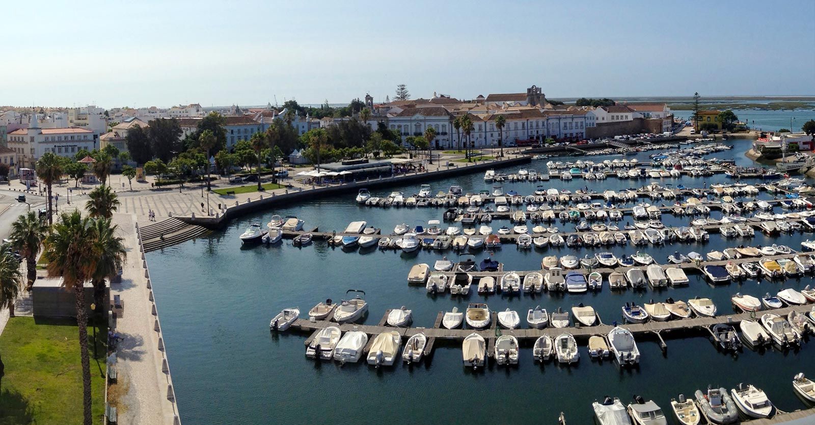
## Description Faro Marina is one of the most picturesque and lively spots in the Algarve region of southern Portugal. Nestled right in the heart of Faro, the marina is a central meeting point where the city’s charm blends seamlessly with its maritime heritage. With a backdrop of palm trees, elegant architecture, and rows of yachts and fishing boats bobbing gently on the water, it’s a place that embodies the relaxed yet vibrant spirit of coastal Portugal. What makes Faro Marina unique is not only its stunning scenery but also its role as a **gateway to the Ria Formosa Natural Park**, one of Portugal’s most beautiful protected lagoons. Many boat tours depart from the marina, offering visitors the chance to explore secluded islands, birdwatch, or enjoy a relaxing cruise at sunset. A little-known fact about Faro Marina is that the **large stork nests perched on lampposts and rooftops** around the harbor are a common sight, adding to its charm and making it a favorite spot for photographers. Another interesting detail is that the marina is often used for cultural events and festivals, turning it into a lively gathering point during summer evenings. ## Location Faro Marina is located in **Faro, the capital of the Algarve region in Portugal**. It sits right by the **city center**, just across from the historic old town and within walking distance of landmarks such as the **Arco da Vila** and **Faro Cathedral**. Its central location makes it a natural starting point for exploring both the city and the Algarve coastline. ### Recommendation on How to Get There From **Faro Airport**, the marina is only about a **10-minute drive** or a 15-minute bus ride on the airport shuttle. If you’re arriving by train or bus, both stations are within a short walking distance of the marina. For those exploring the Algarve by car, Faro is well-connected by road, and public parking is available near the city center. ## Tips Here are some helpful tips to make your visit to Faro Marina memorable: * **Take a Boat Tour**: Don’t miss the opportunity to explore the Ria Formosa islands, such as Ilha Deserta or Ilha do Farol, by booking a boat tour directly from the marina. * **Enjoy a Sunset Drink**: The waterfront is lined with cafés and bars—perfect for enjoying a glass of Portuguese wine or a cocktail while watching the sun go down. * **Photography Spot**: Bring your camera, especially for capturing the boats, the palm-fringed promenade, and the storks nesting nearby. * **Combine With Old Town Visit**: Since the marina is next to Faro’s historic district, combine your visit with a walk through cobbled streets, museums, and churches. * **Best Time to Visit**: Early evening is ideal, as the marina lights up beautifully, and the temperature is more comfortable during warmer months. * **Look Out for Events**: During summer, concerts, markets, and festivals are often held at or near the marina, adding extra vibrancy to your visit. ## Conclusion Faro Marina is more than just a harbor—it’s a cultural and social hub that captures the essence of Faro and the Algarve. With its stunning waterfront views, lively atmosphere, and easy access to natural wonders like the Ria Formosa, it’s a must-visit spot for anyone traveling to southern Portugal. Whether you’re taking a boat tour, enjoying a drink by the water, or simply strolling along the promenade, Faro Marina is sure to leave a lasting impression. ## FAQ **1. What can I do at Faro Marina?** You can enjoy boat tours to the Ria Formosa islands, dine at waterfront cafés, attend local events, or simply relax and admire the views. **2. Is Faro Marina close to the city center?** Yes, it’s located in the heart of Faro and is within walking distance of the historic old town and main transport hubs. **3. Are boat tours available year-round?** Yes, although availability and schedules may vary depending on the season. Summer offers the widest selection of tours. **4. Is it family-friendly?** Absolutely. The marina is pedestrian-friendly and offers plenty of open space, making it great for families with children. **5. Can I see wildlife at the marina?** Yes, you’ll often spot storks nesting nearby, and boat tours will take you to the Ria Formosa lagoon, which is rich in birdlife. **6. How long should I plan to spend at Faro Marina?** A casual visit might take an hour, but if you’re combining it with a boat trip and old town exploration, plan for half a day or more. ## Links * [Official Faro Tourism Office](https://www.faro.pt/en)
GemVoyage Team • World
Izmir
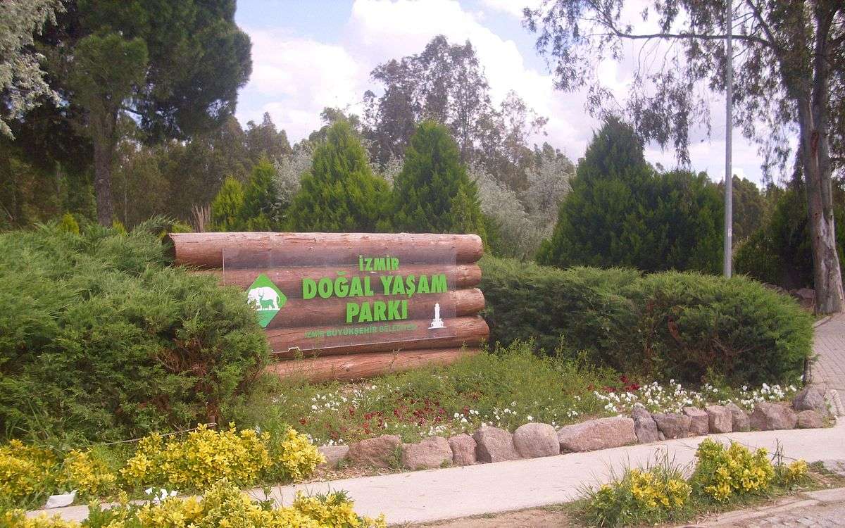
## Description Izmir Wildlife Park (İzmir Doğal Yaşam Parkı) is one of Turkey’s most impressive and thoughtfully designed animal parks, offering a refreshing blend of conservation, education, and recreation. Opened in 2008 by the Izmir Metropolitan Municipality, the park was created as a modern alternative to the old Izmir Zoo, with a strong emphasis on animal welfare and natural habitats. Today, it spans over 425,000 square meters and is home to nearly 1,800 animals from 132 different species. What sets Izmir Wildlife Park apart is its commitment to creating spacious, naturalistic enclosures that mimic the animals’ native environments. Visitors can stroll through themed zones such as the African Savannah, Monkey Islands, Birds of Prey section, and the Tropical Center—the first of its kind in Turkey. The park also features a large pond for waterfowl and a charming Children’s Zoo where kids can interact with friendly farm animals. A little-known fact: the park was awarded by the Organization of Islamic Capitals and Cities (OICC) in 2013 for excellence in municipal services, landscape, and environmental design. Another hidden gem is the Tropical Center, which houses exotic species like macaws, marmosets, fruit bats, and crocodiles in a climate-controlled environment that replicates rainforest conditions. ## Location Izmir Wildlife Park is located in **Turkey**, in the **Aegean Region**, within the city of **Izmir**, specifically in the **Çiğli district**. It’s situated in the Sasalı neighborhood, a peaceful area surrounded by nature and away from the city’s hustle. ### How to Get There: - **By Public Transport**: From central Izmir, take the İZBAN commuter train to Çiğli Station, then transfer to bus number 751 or 777 toward Sasalı. - **By Car**: The park is about a 30-minute drive from downtown Izmir. Free parking is available on-site. - **By Tour**: Some local tour operators include the park in family-friendly itineraries, often paired with nearby attractions like the Bird Paradise (Kuş Cenneti). Its accessibility and tranquil setting make it an ideal day trip for families, nature lovers, and curious travelers. ## Tips for Visitors To make the most of your visit to Izmir Wildlife Park, keep these tips in mind: - **Arrive Early**: The park opens at 9:00 AM and closes at 6:30 PM. Early visits offer cooler temperatures and more active animals. - **Wear Comfortable Shoes**: The park is vast and designed for walking. Expect to spend 2–3 hours exploring. - **Bring Snacks and Water**: While there are cafes and kiosks, bringing your own refreshments can be handy, especially for kids. - **Check for Events**: The park occasionally hosts educational workshops and seasonal events—check the schedule before you go. - **Respect the Animals**: Feeding is prohibited, and loud noises can disturb the animals. Be mindful and enjoy observing them in peace. - **Visit on Weekdays**: Weekends can be crowded. A weekday visit ensures a quieter, more relaxed experience. ## Conclusion Izmir Wildlife Park is a beautifully curated sanctuary that blends education, conservation, and leisure. With its diverse animal collection, spacious habitats, and family-friendly atmosphere, it’s a standout destination in Turkey’s Aegean region. Whether you're traveling solo or with kids, this park offers a memorable and meaningful encounter with wildlife. ## FAQ **1. What are the opening hours of Izmir Wildlife Park?** The park is open daily from 9:00 AM to 6:30 PM, except Mondays when it’s closed for maintenance. **2. Is there an entrance fee?** Yes, but it’s very affordable. Ticket prices are modest, making it accessible for all visitors. **3. Can I bring food into the park?** Yes, you can bring your own snacks and water, though there are also cafes and kiosks available. **4. Is the park suitable for children?** Absolutely. The Children’s Zoo and interactive exhibits make it a great destination for families. **5. Are guided tours available?** While self-guided visits are common, some educational programs and group tours can be arranged in advance. **6. Is the park wheelchair accessible?** Yes, most paths are accessible, and facilities are designed to accommodate visitors with mobility needs. ## Links - [Izmir Wildlife Park – Official Website](https://www.izmirdogalyasamparki.org.tr/en/home) - [Izmir Wildlife Park – Wikipedia](https://en.wikipedia.org/wiki/%C4%B0zmir_Wildlife_Park)
GemVoyage Team • World
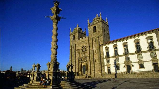
Porto
## Description Porto Cathedral, known locally as **Sé do Porto**, is one of the most iconic and historically significant landmarks in northern Portugal. Perched atop a hill in the heart of Porto’s old town, the cathedral dominates the city skyline with its fortress-like façade and commanding views over the Douro River. Construction began in the early 12th century, making it one of the oldest monuments in Porto and a cornerstone of the city’s religious and architectural heritage. The cathedral is a fascinating blend of **Romanesque, Gothic, and Baroque** styles, reflecting centuries of architectural evolution. Its original Romanesque structure is still visible in the heavy granite walls and narrow nave, while later Gothic additions include the elegant cloister and the funerary chapel of João Gordo, a Knight Hospitaller. In the 18th century, Italian architect Nicolau Nasoni added Baroque flourishes, including a grand loggia and ornate altarpieces. A little-known fact: Porto Cathedral was the site of the royal wedding between **King John I of Portugal and Philippa of Lancaster** in 1387, a union that sealed the Anglo-Portuguese Alliance—one of the oldest diplomatic alliances in the world. Another hidden gem is the **Camino de Santiago pilgrim’s credential office**, tucked discreetly beside the cathedral, where modern-day pilgrims begin their journey to Santiago de Compostela. ## Location Porto Cathedral is located in **Portugal**, within the **Norte Region**, in the city of **Porto**. It sits in the **Sé neighborhood**, one of the oldest quarters of the city, surrounded by winding cobbled streets and historic buildings. ### How to Get There: - **By Metro**: The nearest station is São Bento, just a short uphill walk from the cathedral. - **By Foot**: If you're exploring central Porto, the cathedral is easily accessible from landmarks like the Ribeira, Clérigos Tower, and Dom Luís I Bridge. - **By Taxi or Ride-Hailing**: Services like Bolt or Uber can drop you off at Terreiro da Sé, the square in front of the cathedral. Its elevated position makes it a perfect starting point for exploring Porto’s historic center. ## Tips for Visitors To make the most of your visit to Porto Cathedral, keep these tips in mind: - **Visit Early or Late**: The cathedral can get crowded during peak hours. Early morning or late afternoon visits offer a quieter experience and better lighting for photos. - **Explore the Cloister**: Don’t miss the Gothic cloister, adorned with beautiful azulejos (blue tiles) depicting religious scenes. - **Climb for Views**: The cathedral’s terrace offers panoramic views of Porto’s rooftops and the Douro River—perfect for photography. - **Combine with Nearby Attractions**: Pair your visit with São Bento Station, Palácio da Bolsa, or a walk down to the Ribeira district. - **Check for Mass Times**: If you’re interested in attending a service, check the schedule in advance. Visitors are welcome but should be respectful during religious ceremonies. - **Bring Comfortable Shoes**: The surrounding streets are steep and cobbled—wearing sturdy footwear is a must. ## Conclusion Porto Cathedral is a majestic fusion of history, architecture, and spirituality. With its commanding presence, rich artistic details, and deep cultural significance, it offers visitors a profound glimpse into the soul of Porto. Whether you're a history buff, architecture lover, or spiritual seeker, the Sé do Porto is a must-see. ## FAQ **1. What are the opening hours of Porto Cathedral?** Typically, the cathedral is open from 9:00 AM to 6:30 PM. Hours may vary on holidays and Sundays. **2. Is there an entrance fee?** Entry to the main cathedral is free. A small fee may apply to access the cloister and museum. **3. Can I take photos inside the cathedral?** Yes, photography is allowed, but flash should be avoided, especially during services. **4. Is Porto Cathedral accessible for people with mobility issues?** The main entrance is accessible, but some areas like the cloister and terrace may have limited access due to stairs. **5. How long should I plan for the visit?** A typical visit lasts 45 minutes to an hour, longer if you explore the cloister and museum. **6. Is there a dress code?** Modest attire is recommended, especially if attending a religious service. ## Links - [Portugal.com – Porto Cathedral Overview](https://www.portugal.com/location/porto-cathedral/) - [Porto Travel Guide – Sé do Porto](https://porto.travel/porto-cathedral/)
GemVoyage Team • World
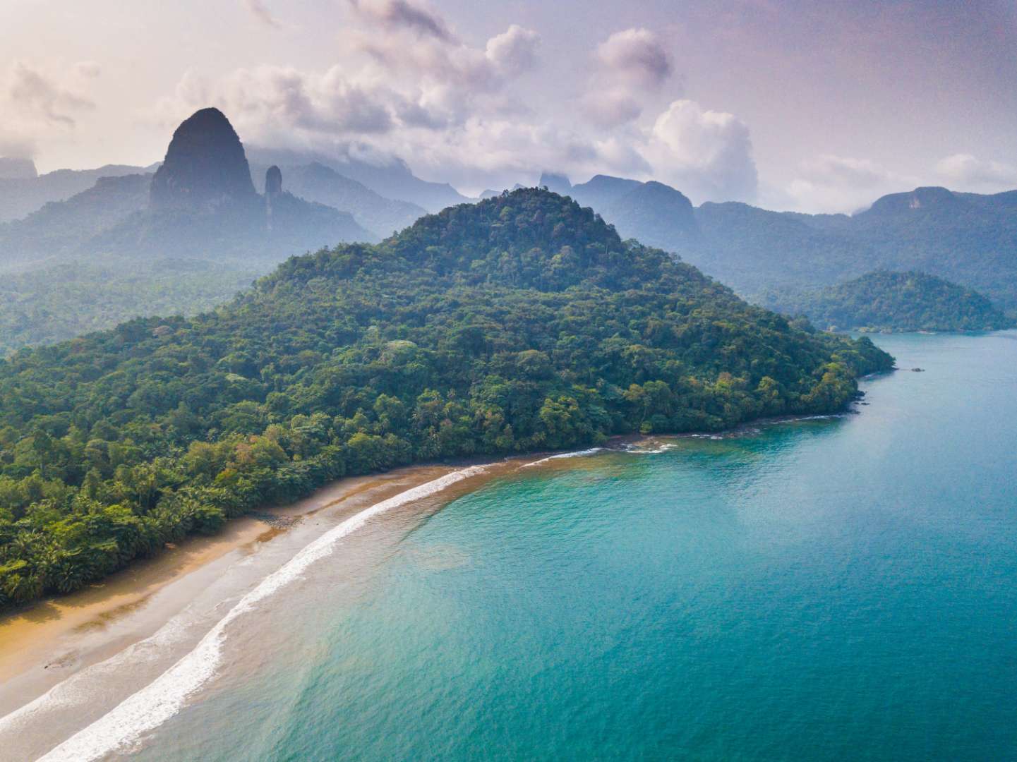
São Tomé and Príncipe
## Description São Tomé Island is a lush, volcanic paradise floating in the Gulf of Guinea, off the western coast of Central Africa. As the larger of the two main islands that make up the nation of São Tomé and Príncipe, it offers a rare blend of untouched nature, vibrant culture, and colonial charm. With its emerald rainforests, dramatic coastlines, and warm, welcoming locals, São Tomé is a destination that feels like a well-kept secret. The island is dominated by Pico de São Tomé, a towering peak that rises to 2,024 meters and is surrounded by dense jungle and misty cloud forests. Much of the island’s interior is protected within the Obô Natural Park, a biodiversity hotspot teeming with endemic species, waterfalls, and hiking trails. Along the coast, you’ll find palm-fringed beaches, fishing villages, and remnants of Portuguese colonial architecture. A little-known fact: São Tomé is located just north of the equator, and you can actually stand on the equator itself by visiting the nearby Ilhéu das Rolas islet. Another fascinating detail is that the island is part of the Cameroon Volcanic Line, a geological formation that includes several volcanic islands and mountains stretching from Cameroon into the Atlantic Ocean. ## Location São Tomé Island is located in the **Democratic Republic of São Tomé and Príncipe**, in the **Gulf of Guinea**, off the coast of **Central Africa**. The capital city, **São Tomé**, is situated on the northeastern coast of the island and serves as the political, cultural, and economic hub. ### How to Get There: - **By Air**: The main gateway is São Tomé International Airport (TMS), which receives flights from Lisbon, Accra, Luanda, and other regional hubs. - **From Europe**: TAP Air Portugal offers direct flights from Lisbon several times a week. - **From Africa**: Regional carriers connect São Tomé with cities like Libreville, Luanda, and Accra. - **Local Transport**: Once on the island, taxis, minibuses, and rental cars are available. Hiring a local guide is highly recommended for exploring remote areas. ## Tips for Visitors To make the most of your São Tomé adventure, keep these tips in mind: - **Best Time to Visit**: June to September is the dry season and ideal for hiking and beach activities. Avoid December to February, which is the rainy season. - **Currency**: The local currency is the São Tomé and Príncipe dobra (STN). Euros are widely accepted, especially in hotels and restaurants. - **Language**: Portuguese is the official language. Learning a few basic phrases can go a long way. - **Local Cuisine**: Don’t miss dishes like moqueca de peixe (fish stew), banana pão (breadfruit), and blá-blá (smoked fish). - **Eco-Tourism**: Respect the island’s fragile ecosystems. Stick to marked trails and avoid disturbing wildlife. - **Connectivity**: Internet access is limited in rural areas. Download maps and travel info in advance. ## Conclusion São Tomé Island is a captivating blend of volcanic landscapes, rich biodiversity, and cultural depth. Whether you're trekking through cloud forests, lounging on secluded beaches, or exploring colonial-era plantations, the island offers a peaceful and authentic escape from the modern world. ## FAQ **1. Is São Tomé Island safe for tourists?** Yes, São Tomé is considered one of the safest countries in Africa. Petty theft can occur, so basic precautions are advised. **2. Do I need a visa to visit São Tomé?** Visa requirements vary by nationality. EU citizens can enter visa-free for short stays. Check with your local embassy before traveling. **3. What is the official language of São Tomé?** Portuguese is the official language. Creole languages like Forro and Angolar are also spoken. **4. Can I hike Pico de São Tomé?** Yes, but it’s a challenging multi-day trek. Hiring a guide is essential due to the dense forest and changing weather. **5. Are there good beaches on São Tomé Island?** Absolutely. Praia das Conchas, Praia Jalé, and Praia Micondó are among the most beautiful and least crowded. **6. Is São Tomé suitable for family travel?** Yes, though infrastructure is basic. Families should plan ahead for accommodations and transport. ## Links - [São Tomé Island – Wikipedia](https://en.wikipedia.org/wiki/S%C3%A3o_Tom%C3%A9_%28island%29) - [Visit São Tomé – Official Tourism Portal](https://www.visitsaotomeprincipe.st/)
GemVoyage Team • World
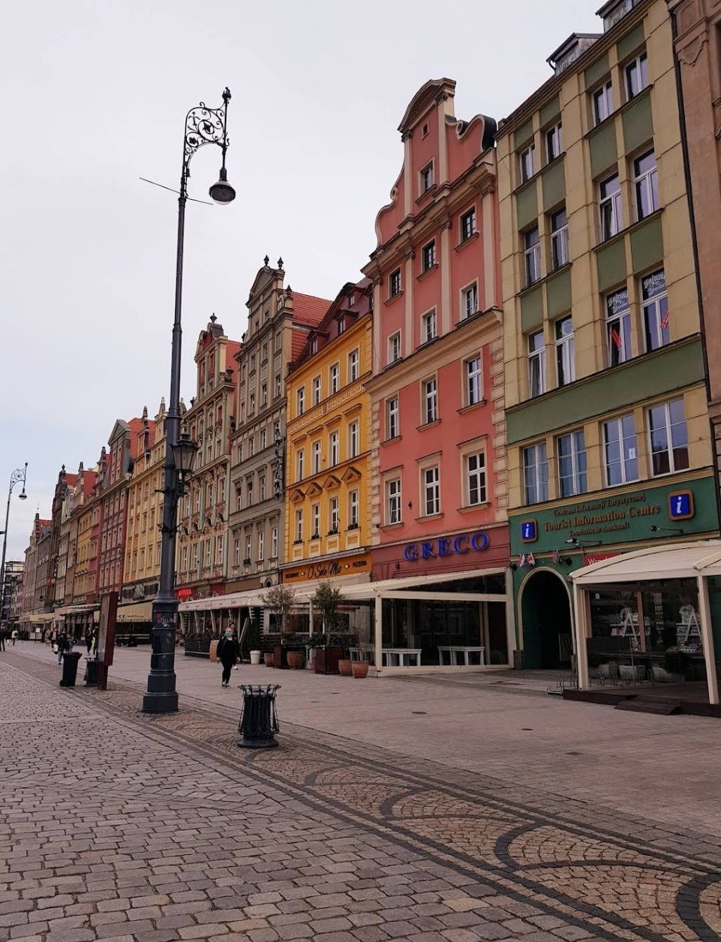
Wroclaw
## Description The **Old City of Wroclaw**, also known as **Stare Miasto**, is one of the most enchanting historic centers in Poland. With its cobblestone streets, Gothic and Baroque architecture, and vibrant market square, the Old City blends centuries of history with modern-day charm. Visitors are greeted by the **Rynek (Market Square)**, one of the largest medieval squares in Europe, surrounded by colorful townhouses, cafés, and cultural landmarks. At its heart stands the **Wroclaw Town Hall**, a masterpiece of Gothic architecture that has been a symbol of the city since the 13th century. What makes Old City Wroclaw especially unique is its blend of influences. Throughout history, Wroclaw was ruled by Poland, Bohemia, Austria, Prussia, and Germany before finally becoming part of modern Poland after World War II. This rich mix is reflected in its architecture, traditions, and even cuisine. A little-known fact about Wroclaw is its population of **over 600 small bronze gnome statues**, scattered throughout the Old City. Known as **Krasnale**, these whimsical figures began as a symbol of resistance during the Communist era and have since become a beloved cultural attraction. Another interesting detail is that parts of the Old City were almost completely destroyed during the war but meticulously rebuilt, making it both a symbol of resilience and a living museum of Polish heritage. ## Location The Old City is located in **Wroclaw**, the capital of the **Lower Silesia region in southwestern Poland**. The historic district lies along the **Oder River**, with the Market Square as its central landmark. Reaching Wroclaw is simple. The **Wroclaw Copernicus Airport** connects the city to many European destinations, and from there, the Old City is just a 20–30 minute drive. For domestic travelers, Wroclaw is well connected by train and bus networks, with the main railway station (**Wrocław Główny**) located about 15 minutes from the Old Town by tram or taxi. Walking is the best way to explore once you arrive, as most attractions are within a compact, pedestrian-friendly area. ## Tips To make the most of your visit to Old City Wroclaw, keep these tips in mind: * **Start at the Market Square** – It’s the perfect hub for exploring nearby attractions, shops, and restaurants. * **Look for the gnomes** – Spotting the tiny bronze statues is a fun activity for visitors of all ages. * **Visit Ostrów Tumski** – The Cathedral Island, just outside the Old City, is the oldest part of Wroclaw and offers stunning views of Gothic churches and gas lantern-lit streets. * **Try local food** – Don’t miss pierogi, żurek (sour rye soup), and Wroclaw’s famous craft beers. * **Join a walking tour** – Guided tours provide fascinating insights into the city’s multicultural past and hidden corners. * **Enjoy the nightlife** – The Old City is lively after dark, with pubs, jazz clubs, and cafés filling the medieval streets with energy. ## Conclusion The **Old City of Wroclaw** is a place where history, culture, and modern life come together in perfect harmony. From its magnificent Market Square and medieval landmarks to its quirky gnomes and vibrant atmosphere, the Old City offers something for every traveler. Whether you’re exploring its Gothic churches, enjoying local delicacies, or simply soaking in the atmosphere of its charming streets, Wroclaw’s Old Town is a must-see gem in Poland. ## FAQ **1. What is Old City Wroclaw best known for?** It is famous for its medieval Market Square, Gothic Town Hall, colorful architecture, and unique gnome statues. **2. Can you walk around the Old City in one day?** Yes, most of the attractions are within walking distance, but spending at least two days allows for a deeper experience. **3. What are the gnomes in Wroclaw?** They are small bronze statues known as **Krasnale**, originally a symbol of resistance against communism, now a fun cultural attraction. **4. Is Old City Wroclaw expensive to visit?** Compared to many European cities, Wroclaw is affordable, with budget-friendly food, accommodations, and attractions. **5. When is the best time to visit Wroclaw?** Spring and summer are ideal for outdoor exploration, while December is magical thanks to the Christmas market in the Old Town Square. **6. Is the Old City family-friendly?** Yes, children especially enjoy searching for the gnome statues, and the pedestrian-friendly streets make it safe for families. ## Links * [Visit Wroclaw – Official Tourism Website](https://www.visitwroclaw.eu)
GemVoyage Team • World
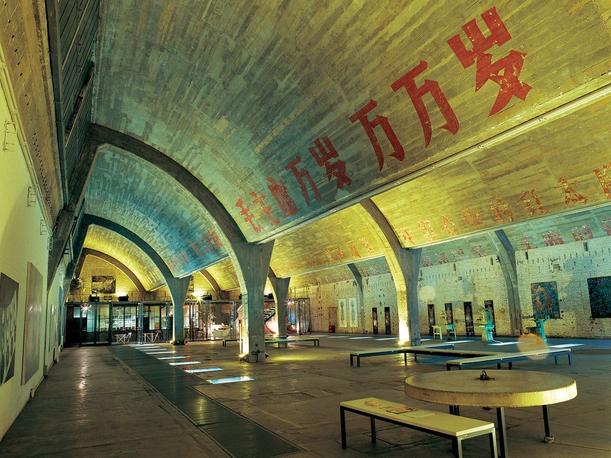
Beijing
## Description Tucked in the northeastern corner of Beijing, the 798 Art District is one of the most compelling destinations in all of China. What was once a sprawling complex of military and industrial factories has been transformed into a world-class hub for contemporary art, design studios, galleries, cafes, and cultural institutions. The district draws millions of visitors each year, from seasoned art collectors to curious travelers who simply want to walk through one of Asia's most visually striking urban landscapes. The complex was originally built in the 1950s with assistance from East German engineers, and the architecture reflects that influence heavily. The Bauhaus-inspired buildings, with their distinctive sawtooth roofs designed to let in consistent northern light, still stand largely intact. They now house some of the most important contemporary art galleries in Asia. Walking through the district feels like moving through layers of history: Cold War-era industrial slogans still painted on the walls sit side by side with bold modern installations and cutting-edge sculpture. One little-known fact about 798 is that it was artists and designers who moved in illegally during the late 1990s and early 2000s, attracted by the cheap rent and massive open spaces, before the government formally recognized it as a cultural zone in 2006. Another lesser-known detail is that the district is named after Factory 798, which was just one of many factories in the complex known collectively as the 718 Joint Factory, originally built as part of China's first Five-Year Plan. Today, the 798 Art District is home to over 200 galleries and art spaces, including branches of internationally recognized institutions. The streets between buildings are filled with large-scale outdoor sculptures and murals, making even a casual stroll through the area feel like a walk through an open-air museum. Annual events like the Beijing International Art Biennale and 798 Art Festival bring the district's creative energy to its peak. ## Location The 798 Art District is located in the Chaoyang District of Beijing, China, in an area called Dashanzi. It sits in the northeastern part of the city, not far from the Beijing Capital International Airport and within reasonable distance of major city landmarks. The most convenient way to get there is by taking the Beijing Subway to Line 14 and exiting at Jiangtai Station, from which the district is about a 10 to 15 minute walk or a short taxi ride. Alternatively, many visitors take a taxi or use a ride-hailing app like DiDi directly to the 798 Art District entrance. Buses also serve the area, with several routes stopping near Dashanzi. Despite being somewhat off the typical tourist trail, it is well connected to the rest of the city. For those staying in central Beijing near Sanlitun or the CBD area, the journey by taxi typically takes 20 to 30 minutes depending on traffic. ## Tips - **Go on a weekday if possible.** Weekends, especially during festivals and national holidays, can see very large crowds. Visiting on a Tuesday or Wednesday will give you a quieter, more contemplative experience. - **Wear comfortable shoes.** The district is large and most of the experience involves walking on uneven ground, past industrial spaces and outdoor installations. Good walking shoes make a considerable difference. - **Allocate at least half a day.** There is far more to see here than most people expect. A proper visit to even a fraction of the galleries and outdoor spaces takes a minimum of three to four hours. - **Many galleries are free.** While some exhibitions charge entrance fees, a large number of the galleries in 798 are free to enter. Always check at the door before assuming you need to purchase a ticket. - **Bring cash as well as a card.** Some smaller cafes, shops, and studios may not accept international credit cards. Having some Chinese yuan on hand is always helpful. - **Visit in spring or autumn.** Beijing's summers are hot and humid, and winters are extremely cold. The spring months of April and May and the autumn months of September and October offer the most comfortable conditions for exploring the outdoor areas. - **Check the event calendar in advance.** The district hosts rotating exhibitions, openings, and festivals that can significantly enhance your visit. Checking what is on before you go is always worthwhile. ## Conclusion The 798 Art District is far more than a tourist attraction. It is a living, breathing creative community that offers a genuine window into contemporary Chinese culture and the global art world. Its unique combination of preserved industrial architecture, international-caliber art, and vibrant street life makes it unlike anywhere else in Beijing or, indeed, in the world. Whether you are an art enthusiast, a photographer, a design professional, or simply a curious traveler, the 798 Art District deserves a place near the top of your Beijing itinerary. ## FAQ **What are the opening hours of the 798 Art District?** The outdoor streets and public areas of the district are accessible at all hours, but most individual galleries and studios are open from around 10:00 AM to 6:00 PM. Hours can vary by gallery, and some are closed on Mondays. It is advisable to check specific gallery websites if you have particular venues in mind. **Is the 798 Art District free to visit?** Entry to the district itself is free. Many of the galleries and outdoor installations are also free. However, some exhibitions and events charge admission fees. Budget a small amount in case anything you want to enter requires a ticket. **How much time should I spend in the 798 Art District?** Most visitors find that three to five hours is ideal for a satisfying visit. If you are a serious art enthusiast or plan to visit multiple galleries in depth, a full day is not excessive. **Is the 798 Art District suitable for children?** Yes, in general the district is suitable for families. The outdoor sculptures and the visual spectacle of the space tend to engage younger visitors. Some contemporary art exhibitions may contain mature themes, so parents should use their discretion when entering individual galleries. **Are there places to eat and drink in the district?** Yes, there is a good variety of cafes, restaurants, and small eateries scattered throughout the district. Options range from local Chinese food stalls to international cafes and upscale dining. The area is well suited for a leisurely lunch or a coffee break between gallery visits. **How large is the 798 Art District?** The district covers an area of approximately 60,000 square meters. It contains hundreds of galleries, studios, shops, and eating establishments across a network of streets and converted industrial buildings. ## Links - [798 Art District on Wikipedia](https://en.wikipedia.org/wiki/798_Art_Zone) - [Beijing Tourism Official Website](https://www.visitbeijing.com.cn)
GemVoyage Team • World
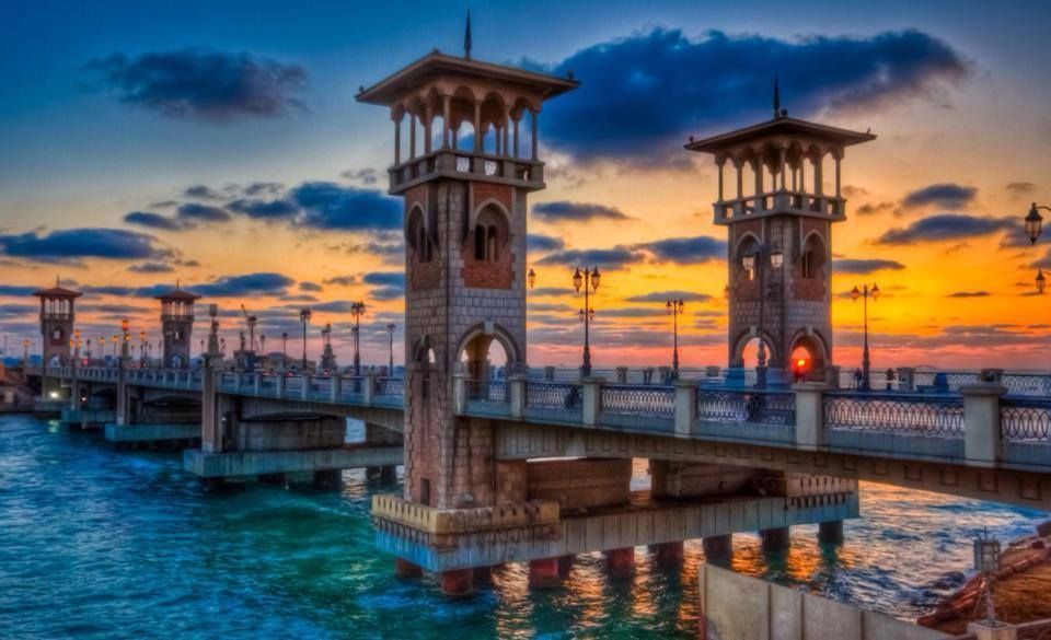
Alexandria
## Description The Stanley Bridge Corniche Walk is one of the most enjoyable ways to experience Alexandria’s seaside character because it brings together a famous city landmark and the broader rhythm of the Mediterranean waterfront. Stanley Bridge itself is a recognizable symbol of modern Alexandria, but what makes the area memorable is not only the bridge as an object. It is the surrounding promenade, the sea air, the movement of people, the views toward the coastline, and the way the corniche helps connect the city’s urban life with its maritime setting. For visitors, this is the kind of place that turns a simple walk into an experience of atmosphere. The bridge and the walkway around it are especially appealing because they capture Alexandria’s layered identity. The city has ancient roots, but much of its contemporary charm comes from places where residents and visitors mix along the water. A lesser-known fact is that the Stanley area is relatively modern compared with Alexandria’s ancient core, yet it has become one of the city’s most photographed and recognizable places because of its coastal setting and architectural profile. Another detail worth noticing is how the area changes across the day: morning brings a softer, more reflective mood, while evening often becomes livelier as people come out for a breezy promenade. For travelers, the walk is rewarding because it offers a sense of place without requiring a formal agenda. You can simply move along the corniche, stop for photos, watch traffic and waves, and enjoy the city unfolding in layers. The bridge frames the sea and the shoreline in a way that feels distinctly Alexandrian, and the surrounding area is often a pleasant place to pause, drink something cold, or continue toward nearby stretches of the waterfront. That flexibility is exactly why this walk belongs in an Alexandria itinerary. The best part may be how accessible it feels. You do not need special preparation to appreciate it. The waterfront itself does the work, offering changing light, open views, and a strong sense of local daily life. ## Location Stanley Bridge Corniche Walk is located in Alexandria, Egypt, along the city’s Mediterranean waterfront in the Stanley district. The walk sits on the Corniche, Alexandria’s main coastal boulevard, which makes it easy to locate and simple to fold into a broader day in the city. Because it is part of the public waterfront, the area is easy to approach and does not require special ticketing or entrance procedures. Getting there is usually easiest by taxi, rideshare, or local transport depending on where you are staying in Alexandria. Walking is ideal if you are already nearby, since the whole point of the experience is to enjoy the seafront at a human pace. If you are planning a longer sightseeing route, Stanley works well as a connecting point between central Alexandria and other coastal areas. The best way to enjoy it is to arrive with enough time to linger. A short pass-through is fine, but the waterfront rewards slowing down. Sunset is especially attractive for light and atmosphere, though morning can be calmer and better for a more relaxed walk. ## Tips Choose comfortable shoes, even though the route is simple. A pleasant walk often turns into a longer one than expected. Visit near sunset if you want the most dramatic light and the most social atmosphere. Do not focus only on the bridge itself. The surrounding corniche is what gives the experience its full value. Be aware of traffic and keep an eye on crossings. Like many urban waterfronts, the area is lively and active. Combine the walk with a café stop or a meal nearby so the outing feels complete rather than rushed. ## Conclusion The Stanley Bridge Corniche Walk is one of Alexandria’s most enjoyable low-effort experiences, blending sea views, city life, and a strong sense of place. It is ideal for travelers who want to feel the Mediterranean character of the city without needing a formal attraction schedule. ## FAQ ### Is the Stanley Bridge area good for tourists? Yes. It is one of Alexandria’s most scenic and accessible waterfront spots, with strong appeal for casual visitors and photographers. ### How long should I spend there? Anywhere from 30 minutes to 2 hours, depending on whether you are simply passing through or lingering for a walk and a meal. ### Is it better in the day or evening? Both work well. Daylight is good for seeing the sea clearly, while evening often feels more atmospheric and social. ### Do I need a ticket? No. The corniche is a public waterfront area, so the experience is generally open and walkable. ## Links - [Alexandria on Wikipedia](https://en.wikipedia.org/wiki/Alexandria)
GemVoyage Team • World