Discover extraordinary places shared by our community of travelers
Rome
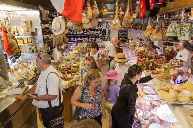
## Description Testaccio Market (Mercato Testaccio) is a lively, authentic food market at the heart of one of Rome’s most food-forward neighborhoods. Unlike the tourist-heavy markets closer to the historic center, Testaccio retains a working-market energy: long-time vendors sell seasonal fruit and vegetables, butchers and fishmongers prepare daily stock, and small eateries and street-food counters push culinary tradition forward. The market is famed for staples such as porchetta sandwiches, supplì and a wide selection of Italian cheeses and cured meats, while newer artisanal stalls introduce contemporary flavors, craft gelato and fusion snacks. What distinguishes Testaccio is its deep connection to the local history. Monte Testaccio—an artificial mound of broken amphorae from the Roman period—anchors the area’s archaeology and speaks to the neighborhood’s centuries-long role as Rome’s distribution and storage quarter. That heritage informs the food culture: local producers, family-run stalls and traditional recipes coexist with experimental kitchens, meaning a single visit can offer both classic Roman comfort foods and creative reinterpretations. The market’s compact layout makes it an ideal stop for tasting rather than full dining—sample multiple vendors over a morning and build a small feast. Culinary tours often include the market because it presents both quality ingredients and convivial daily life: you’ll hear vendors bartering, watch knives at work behind counters, and find specialty shops selling olive oil, aged cheeses and regional preserves. ## Location Testaccio Market is located in the heart of the Testaccio neighborhood, south of the Aventine Hill and a short ride from Rome’s historic center. The nearest metro stop is Piramide on Line B; several bus routes also serve the area, and many visitors walk from nearby neighborhoods like Trastevere or the Aventine for a scenic stroll. The market is close to other attractions—Pyramid of Cestius, riverfront walks and a lively restaurant scene—making it easy to build a food-focused itinerary. If you prefer to mix shopping with sightseeing, plan an early morning visit for the freshest produce and a quieter atmosphere, or go mid-afternoon to sample street food and sample plates as vendors prepare for evening trade. ## Tips - Arrive in the morning for peak freshness and to see the market at full pulse; many vendors begin packing up by late afternoon. - Be adventurous with sampling: try porchetta, supplì, fresh pasta to-go and the market’s cured meats—ask vendors for their recommendations. - Carry small change and a reusable bag; while many places accept cards now, smaller stalls still prefer cash. - If you want a guided tasting, several local food tours include the market and introduce signature stalls and historical anecdotes. - After browsing, explore nearby eateries in Testaccio for fuller meals or head to the riverfront for a relaxed walk. ## Conclusion Testaccio Market is a living portrait of Roman food culture: hands-on, edible and evolving. It’s the place to taste ingredients in their most immediate form, to listen to local foodways in conversation and to discover how centuries of commerce and community shaped a distinctly Roman palate. For culinary travelers seeking authentic flavors and friendly vendor encounters, Testaccio remains indispensable. ## FAQ Q: What are the market’s opening hours? A: Hours vary by stall, but most vendors open early morning and many close by late afternoon; specialty eateries may open again for evening service—check specific stall times if you have a destination vendor. Q: Can I eat on-site or should I take food away? A: Both. Many stalls prepare foods to eat immediately and provide small eating areas or counters; taking items to nearby picnic spots or a short walk is also common. Q: Is Testaccio Market suitable for dietary restrictions? A: Yes—ask vendors about ingredients. You can find vegetarian pasta, vegetable-based dishes and some stalls that accommodate allergies, but always ask about preparation and cross-contamination. Q: Are there guided tours of the market? A: Yes, several local food-tour operators include Testaccio in tasting itineraries; a guided tour is a great way to discover favorite stalls and sample local specialties. Q: Is the market touristy? A: Testaccio retains a local feel despite growing interest from visitors; early mornings are best for a more authentic experience. ## Links - [Testaccio](https://www.lavitaroma.com/blog/2017/03/17/testaccio-market-rome)
GemVoyage Team • World
Plateliai
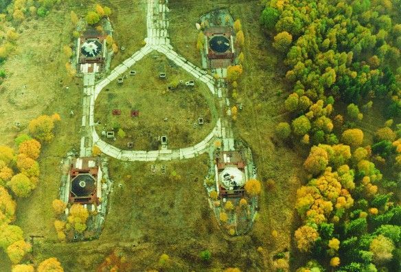
## Description The Plokštinė missile base, now preserved as the Cold War Museum near Plateliai, offers a rare and visceral encounter with twentieth-century strategic history. The site is a remarkably intact example of Soviet military engineering: deep underground launch tunnels, reinforced command bunkers, and surface infrastructure that hint at a wartime readiness now frozen in time. Unlike many museums that reconstruct events with replicas, Plokštinė retains original concrete, rusted metalwork, and patched wiring—materials that convey the scale and urgency of deterrence planning. What makes Plokštinė particularly compelling is its layered storytelling. Exhibits interweave technical descriptions of missile systems and launch protocols with human-scale narratives—photos of personnel, uniforms, diaries and municipal records that emphasize the lived experience of those stationed there. Guided tours often highlight operational details (how crews were rotated, how shelters were maintained) while reflecting on the broader geopolitical context: why land-based missile sites mattered to Soviet strategy and how their presence reshaped local communities. Conservation at Plokštinė has a museum-like rigor: lighting and interpretation are carefully placed to preserve fragile surfaces while enabling visitors to read inscriptions and see equipment. In the tunnels, the stone and concrete surfaces absorb sound, producing an almost cathedral-like hush that encourages reflection. The juxtaposition of heavy engineering and intimate domestic artifacts—the letter folded inside a pocket, a tea set on a service table—creates a human counterpoint to the site's strategic purpose. ## Location Plokštinė sits in western Lithuania near the small town of Plateliai in the Plungė district (Telšiai County), set against the pine and mixed-forest landscapes of Žemaitija National Park. The remoteness is part of the site’s character: the base was intentionally sited away from population centers, hidden by terrain and vegetation. Visitor research note: Scholars and Cold War enthusiasts should contact the museum ahead of time if they plan to consult archival materials or request deeper access for research purposes. Curators sometimes facilitate focused visits or point researchers toward local archives and oral-history resources that provide fuller context. How to get there: the most practical way to visit is by car, with the drive from Plateliai or Plungė taking under an hour depending on route and conditions. Local tour operators in Plateliai sometimes offer organized visits, which can include transport and guided interpretation. Public transport is sporadic — taxis from Plateliai or Plungė are the pragmatic alternative for visitors without private vehicles. Be mindful that signage outside the immediate museum area can be limited; bring offline maps or GPS coordinates when traveling. ## Tips - Book guided tours in advance when possible; on-site staff provide technical context and safety briefings that enhance understanding. - Dress for underground conditions: temperatures in tunnels are lower and the ground can be uneven and damp; sturdy shoes and a light jacket are recommended. - Respect restricted areas and posted rules; some sections may be closed to preserve sensitive structures or materials. - Photography: allowed in many parts, but check signage for restrictions in operational or fragile zones; avoid flash where plaster or pigments may be vulnerable. - Combine the visit with natural attractions: Plateliai Lake and Žemaitija National Park are nearby and make for a well-rounded day trip. - Bring water and snacks, as amenities near the site are limited; local cafes in Plateliai provide a pleasant break before or after a tour. ## Conclusion The Plokštinė Cold War Museum is a vivid public history site where engineering, geopolitics, and local memory intersect. It invites visitors to slow down and consider the practical technologies of deterrence alongside the human routines that sustained a military outpost. For scholars, photographers, and travelers interested in Cold War heritage, Plokštinė offers an uncommonly honest look at a world that once revolved around secrecy and rapid readiness. ## FAQ Q: Can visitors go inside the missile tunnels? A: Yes—guided tours typically include accessible sections of the underground complex. Access depends on safety conditions and conservation work, so check current availability and any age or mobility restrictions before you travel. Q: How long should I plan for a visit? A: Plan for at least two hours to experience the museum and tunnels at a relaxed pace; a guided tour plus time to read exhibits and explore surface ruins may take three hours. Q: Are tours available in English? A: Some tours and interpretive materials are available in English, but availability varies. Contact the museum or local tourism offices for the current language options and to request an English-speaking guide. Q: Is Plokštinė suitable for children? A: Older children and teens typically find the site fascinating, especially with a guide to explain technical details. Very young children may find confined spaces and sombre themes unsettling; consider the itinerary and their comfort. Q: Is the site accessible for visitors with reduced mobility? A: The underground and older structures have limited accessibility due to stairs, uneven surfaces, and narrow corridors. Visitors with mobility concerns should contact the museum ahead of time to discuss options and view accessible areas. ## Links - [Plokštinė missile base / Cold War Museum](https://coldwarsites.net/country/lithuania/plokstine-missile-base-museum-of-cold-war-plateliai/)
GemVoyage Team • World
Tirana
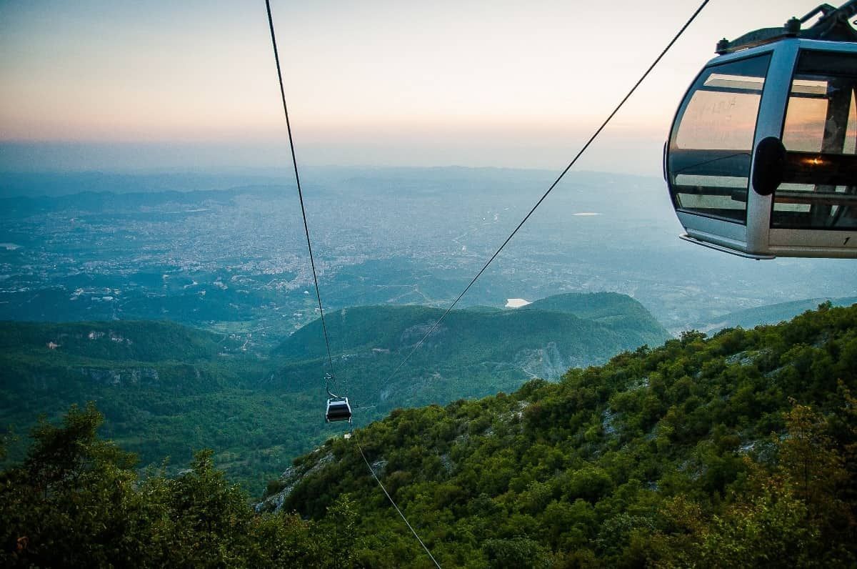
## Description The Dajti Mountain Cable Car, often known as Dajti Express, is one of Tirana’s most memorable experiences because it turns the journey itself into the attraction. Instead of treating the mountains as a distant backdrop, the cable car lifts you gradually from the city’s edge into a greener, quieter world with wide views over the Albanian capital and beyond. For visitors who want to understand Tirana’s geography in a single motion, it is an ideal introduction. What makes the ride special is the contrast. One moment you are near the urban fringe, where streets, buildings, and traffic define the scene; the next, you are moving above slopes and trees with a far more relaxed atmosphere. That dramatic shift is part of the appeal. You do not need to be an adventure traveler to enjoy it. The cable car is accessible, scenic, and unusually effective at showing how quickly the landscape rises around the city. One little-known fact is that Mount Dajti has long served as a natural escape for Tirana residents who want cooler air and open space without going far from the city. Another is that the cable car experience is often most rewarding on days with clear visibility, when the city and surrounding hills spread out in layers below you. The view changes with weather and season, so repeat visitors often discover a different mood each time. The attraction is also useful because it can anchor a full half-day rather than just a single ride. Once you arrive at the upper station, you can enjoy the mountain environment, look out over the city, eat, walk, or simply take in the more spacious setting. That makes the cable car more than transportation. It is a gentle transition from urban Albania to a mountain viewpoint with a strong sense of release. ## Location The cable car operates on the eastern outskirts of Tirana, Albania, ascending toward Mount Dajti and the surrounding national park area. It is close enough to the city to make for an easy excursion, but far enough to feel like a proper escape. Because it is on the edge of the urban area, it is especially convenient to pair with other Tirana sights in the same day. The simplest way to get there is by taxi, ride-hailing service, or private car. Public transport options may require more planning, so many visitors prefer a direct ride to the departure point. If you are staying in central Tirana, plan for a comfortable transfer rather than assuming you can walk. Once at the base station, the cable car itself is straightforward and easy to use. To make the most of the visit, choose a clear day if possible and avoid squeezing the ride into the last minutes of your schedule. The experience is best when you can spend time both on the ascent and at the top. ## Tips - Go on a clear day for the best views. Visibility is a major part of the experience. - Check operating hours and weather conditions before leaving central Tirana. - Bring a light layer, especially if you plan to stay at the top. The temperature can feel different from the city. - Combine the cable car with time at the summit rather than treating it only as a quick ride. - Use the ride to understand Tirana’s geography. It is one of the easiest ways to see how the city meets the surrounding hills. ## Conclusion The Dajti Mountain Cable Car is a simple but memorable way to rise above Tirana and enjoy a calmer, greener setting. It turns a mountain outing into an easy, scenic experience that works for many kinds of travelers. ## FAQ ### Is the cable car suitable for families? Yes. It is a relaxed activity that does not require special fitness or equipment, which makes it a good option for a wide range of visitors. ### How long should I plan for the visit? Plan for more than just the ride. The ascent, time at the top, and return journey together can easily become a half-day outing. ### Is it better to go in the morning or afternoon? Either can work, but morning often offers clearer air and a calmer start. Late afternoon can also be attractive if you want softer light and a more relaxed pace. ### Do I need a guide? No. The cable car is easy to use on your own, and most visitors can enjoy it independently.
GemVoyage Team • World
Denmark
## Description **Grenen** is one of Denmark’s most extraordinary natural landmarks, where two seas—the **Skagerrak** and the **Kattegat**—dramatically meet. At the northernmost tip of Jutland, visitors can witness the unique sight of waves colliding from different directions, creating a visible line in the water. This natural phenomenon makes Grenen one of Denmark’s most visited and photographed attractions. The area is not just about the sea—it’s a place of raw beauty. The sandbar stretches far out into the water, and as you walk along the beach, you’ll be surrounded by endless skies, shifting sands, and fresh sea air. Many visitors find it both a peaceful and powerful experience. **Little-known facts**: * Grenen has been gradually moving northeast for centuries due to sand and tidal currents. The spit extends a few meters every year, reshaping the coastline bit by bit. * The area is also a paradise for birdwatchers. Because of its geographical location, Grenen is one of the best places in Denmark to spot migratory birds, especially in spring and autumn. --- ## Location Grenen is located just outside **Skagen**, a charming coastal town at the very top of **North Jutland**, in **Denmark**. Skagen itself is known for its distinctive yellow houses with red-tiled roofs and its long artistic tradition, but Grenen is the crown jewel of the area. ### How to get there: * From **Skagen town center**, Grenen is about 3 kilometers away. Visitors can walk, cycle, or take the famous **Sandormen tractor bus**, which transports people directly to the tip of the spit. * If you’re coming from other parts of Denmark, you can reach Skagen by train or bus via Frederikshavn, or by car along the scenic coastal roads. Once in Skagen, Grenen is well signposted and easy to access. --- ## Tips * **Wear suitable shoes**: The sandy terrain can be uneven, and the walk to the very tip can take around 20–30 minutes. Comfortable shoes or sandals are recommended. * **Don’t swim**: Although it may be tempting, swimming at Grenen is strictly discouraged. The currents where the two seas meet are extremely strong and unpredictable. * **Try the Sandormen ride**: The tractor-pulled bus called *Sandormen* has been operating since 1947 and is a fun, practical way to reach the very end of the spit. * **Bring a camera**: The meeting of the seas is a stunning photo opportunity, especially at sunset when the sky lights up in beautiful colors. * **Visit Skagen’s attractions too**: After Grenen, explore Skagen’s art museums, lighthouses, and the nearby Råbjerg Mile, Denmark’s largest migrating sand dune. --- ## Conclusion Grenen is more than just Denmark’s northern tip—it’s a rare natural spectacle where two seas clash, shaping the land and leaving visitors in awe. Its ever-changing landscape, combined with rich wildlife and historical charm, makes it a must-see for anyone traveling to North Jutland. Whether you walk barefoot in the sand, take the Sandormen, or simply sit and admire the horizon, a visit to Grenen promises memories of Denmark’s wild and beautiful coastline. --- ## FAQ **1. What makes Grenen special?** Grenen is where the Skagerrak and Kattegat seas meet, creating a visible collision of waves. It’s also one of Denmark’s most scenic natural areas. **2. Can you swim at Grenen?** No, swimming is not allowed due to extremely strong and dangerous currents at the meeting point of the seas. **3. How do you get to the very tip of Grenen?** You can walk along the beach from Skagen or take the Sandormen tractor bus, which drives visitors directly to the point. **4. Is Grenen suitable for children and families?** Yes, Grenen is family-friendly. Kids usually enjoy the tractor ride and spotting seals or birds along the coast, but parents should keep them away from the water’s edge. **5. Are there animals to see at Grenen?** Yes, Grenen is known for bird migration, and you may also see seals resting on the sandbanks. **6. When is the best time to visit Grenen?** Grenen is open year-round, but the best times are spring and summer for pleasant weather, or autumn for dramatic skies and bird migration. --- ## Links * [Visit Denmark – Grenen](https://www.visitdenmark.com/denmark/plan-your-trip/grenen-skagen-gdk640520) * [Sandormen Tractor Bus – Official Info](https://www.sandormen.dk/)
GemVoyage Team • World
São Paulo
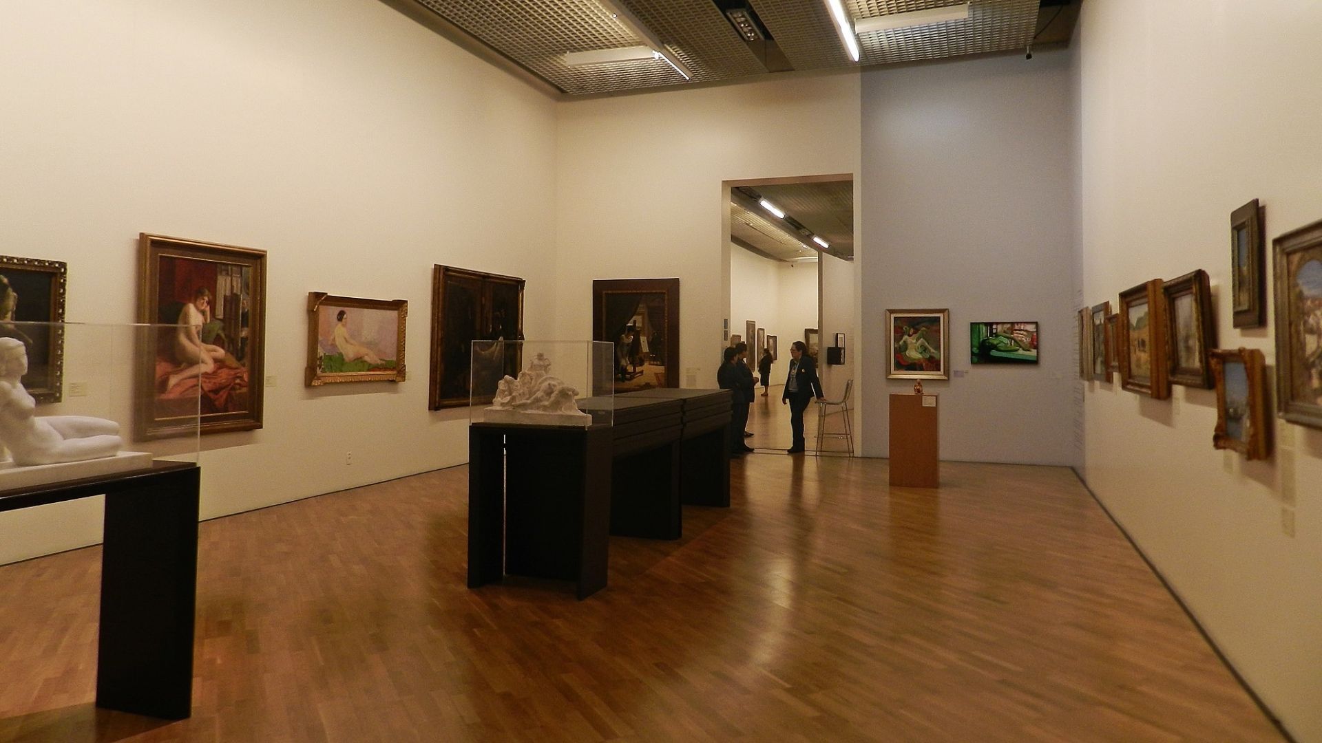
## Description Pinacoteca de São Paulo is one of Brazil’s most important art museums, and it has the kind of presence that makes a visit feel meaningful even before you step inside. Set in a historic building near Luz, the museum combines architecture, collection depth, and curatorial seriousness in a way that appeals to both first-time visitors and dedicated art travelers. It is not simply a place to tick off a museum list. It is one of the essential cultural experiences in São Paulo. The museum’s strength lies in how it balances scale and intimacy. You can encounter major works from Brazilian art history, yet the overall visit still feels navigable and human-sized. The building itself also contributes to the experience, with restored spaces that create a strong sense of continuity between old and new São Paulo. One little-known fact is that the museum occupies one of the city’s most recognizable historic structures, which gives the collection a powerful architectural frame. Another is that the museum’s location near Luz places it in a district shaped by rail history, urban transformation, and cultural reinvention. For travelers, the Pinacoteca is especially rewarding because it helps decode São Paulo’s broader cultural identity. The city is often described through business, scale, and speed, but the museum reveals another side: artistic ambition, historical memory, and deep engagement with Brazilian visual culture. You can spend time with painting, sculpture, and installation works, then step back into the urban landscape with a much richer understanding of the city. The museum is also a good choice for visitors who like structure. Unlike some larger institutions that can feel overwhelming, the Pinacoteca encourages a thoughtful pace. You can move through the galleries at a measured speed, pause where something catches your eye, and still feel that you have had a full and substantial experience. For many people, it becomes one of the most memorable stops in São Paulo because it offers clarity, beauty, and context in equal measure. ## Location Pinacoteca de São Paulo is located in the Luz area of central São Paulo, Brazil, near the city’s historic train and transit hub. The museum sits within easy reach of other central attractions, making it practical to combine with a wider cultural day in downtown São Paulo. The easiest way to get there is by metro or taxi/rideshare. Luz station is the most convenient reference point, and arriving by public transport helps avoid some of the congestion and parking complexity of central São Paulo. Because the area has a busy urban character, it is wise to plan your route in advance and keep your visit focused on museum hours and nearby movement. If possible, avoid arriving in a rush. The museum deserves an unhurried approach, and the surrounding district is best experienced with enough time to orient yourself before entering. ## Tips - Buy or reserve tickets ahead of time when possible, especially on weekends or during special exhibitions. - Give yourself time for both the collection and the building. The architecture is part of the experience. - Visit earlier in the day if you want a quieter atmosphere in the galleries. - Combine the Pinacoteca with other downtown cultural stops so your trip feels efficient and rewarding. - Wear comfortable shoes. Even a museum visit here often becomes part of a broader walking itinerary. ## Conclusion Pinacoteca de São Paulo is a cornerstone of the city’s cultural life and one of the best places to understand Brazilian art in an elegant historic setting. It offers a visit that is both intellectually satisfying and visually rich. ## FAQ ### How much time should I spend at the Pinacoteca? Most visitors benefit from at least two hours, and more if they enjoy reading labels or visiting special exhibitions. It is easy to spend longer if the collection draws you in. ### Is the museum good for first-time visitors to São Paulo? Yes. It is one of the best places to start if you want a strong cultural anchor in the city and an introduction to Brazilian art. ### Do I need to be an art expert to enjoy it? No. The museum is accessible for general visitors while still offering depth for people with more art background. ### Can I visit it with other downtown attractions? Absolutely. Its central location makes it a natural part of a full day in the Luz and downtown area. ## Links - [Pinacoteca de São Paulo official website](https://pinacoteca.org.br/) - [Pinacoteca de São Paulo on Wikipedia](https://en.wikipedia.org/wiki/Pinacoteca_do_Estado_de_S%C3%A3o_Paulo)
GemVoyage Team • World
Tokyo
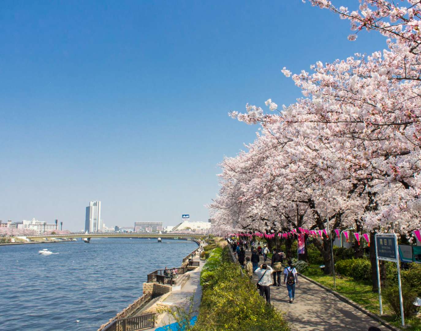
## Description Sumida Park is a serene riverside oasis in the heart of Tokyo, offering a refreshing contrast to the city’s fast-paced urban energy. Stretching along both banks of the Sumida River, the park is located between the Azumabashi and Sakurabashi bridges and provides stunning views of the Tokyo Skytree rising above the skyline. It’s a favorite spot for locals and tourists alike, especially during spring when the park transforms into one of Tokyo’s most celebrated cherry blossom viewing locations. The park’s history dates back to the Edo period, when the riverbanks were popular gathering spots for hanami (cherry blossom viewing), festivals, and leisurely strolls. Today, Sumida Park continues that tradition with over 600 cherry trees lining the paths, creating a tunnel of blossoms that draws thousands of visitors each year. In summer, the park becomes a prime viewing location for the Sumida River Fireworks Festival, one of Japan’s oldest and most spectacular pyrotechnic displays. A little-known fact: the cherry trees in Sumida Park were planted under the orders of shogun Tokugawa Yoshimune in the 18th century, making the park not only a natural retreat but also a living piece of Tokyo’s cultural heritage. Another quirky detail is the nearby Asahi Beer Tower, visible from the park, which was designed to resemble a frothy mug of beer—a playful architectural nod to the area’s modern flair. ## Location Sumida Park is located in **Japan**, in the **Kanto region**, within the **city of Tokyo**. It spans the **Taito and Sumida wards**, with entrances near the historic Asakusa district and the Sumida River waterfront. ### How to Get There - **By Train**: The park is a five-minute walk from Asakusa Station, served by the Ginza Line, Asakusa Line, Tobu Isesaki Line, and Tsukuba Express. - **By Bus**: Several local buses stop near Asakusa and Sumida Park. - **By Water Bus**: The Tokyo Water Bus docks near the park and offers scenic rides to destinations like Odaiba and Hamarikyu Gardens. - **By Foot or Bike**: The park is easily accessible from nearby neighborhoods and is ideal for walking or cycling along the river. Its central location makes it a convenient stop during a day of sightseeing in eastern Tokyo. ## Tips - **Visit During Cherry Blossom Season**: Late March to early April is peak bloom time. Arrive early to avoid crowds and secure a good picnic spot. - **Stay for the Fireworks**: If visiting in late July, plan to attend the Sumida River Fireworks Festival. Arrive hours in advance for a good viewing location. - **Bring a Camera**: The park offers excellent photo opportunities, especially with Tokyo Skytree in the background. - **Explore Both Sides of the River**: Cross the Sakurabashi pedestrian bridge to enjoy views from both banks. - **Pack a Picnic**: There are no large restaurants inside the park, but nearby Asakusa has plenty of takeout options. - **Check for Events**: Seasonal festivals and cultural performances are often held in the park—check local listings for details. ## Conclusion Sumida Park is a tranquil yet culturally rich destination in Tokyo, offering scenic river views, seasonal beauty, and a deep connection to the city’s history. Whether you're admiring cherry blossoms, watching fireworks, or simply enjoying a quiet walk, the park provides a memorable escape in the heart of the metropolis. ## FAQ **1. Is there an entrance fee to Sumida Park?** No, the park is free and open to the public year-round. **2. When is the best time to visit Sumida Park?** Spring (late March to early April) for cherry blossoms and summer (late July) for the fireworks festival. **3. Are there restrooms and facilities in the park?** Yes, there are public restrooms and seating areas throughout the park. **4. Can I bring pets to Sumida Park?** Yes, pets are allowed but should be kept on a leash and cleaned up after. **5. Is the park wheelchair accessible?** Most paths are flat and accessible, though some areas may have uneven terrain. **6. Are there guided tours available?** While not specific to the park, many Asakusa walking tours include Sumida Park as part of their itinerary. ## Links - [Sumida Park – Japan National Tourism Organization](https://www.japan.travel/en/spot/2114/)
GemVoyage Team • World
Alberta
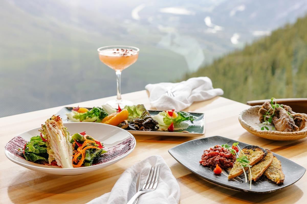
## Description Perched high above the Canadian Rockies, **Sky Bistro** offers one of the most breathtaking dining experiences in **Canada**. Located at the summit of the **Banff Gondola** on **Sulphur Mountain**, this elegant yet relaxed restaurant combines world-class cuisine with panoramic views of six surrounding mountain ranges and the Bow Valley below. The experience at Sky Bistro is about more than just food — it’s a sensory journey that connects visitors to the natural beauty of **Banff National Park**, a UNESCO World Heritage Site. The menu features locally inspired Canadian cuisine crafted with fresh, regional ingredients sourced from Alberta and British Columbia. Signature dishes often include bison, Arctic char, and wild mushrooms, all presented with a modern twist and paired with fine Canadian wines or craft beers. What makes Sky Bistro particularly unique is its **elevation — 2,281 meters (7,486 feet) above sea level** — making it one of the highest dining spots in the country. A lesser-known fact is that the restaurant’s massive floor-to-ceiling windows were designed to reflect the colors of the surrounding peaks, minimizing environmental impact while maximizing views. Another delightful secret: if you time your reservation right, you can watch the sunset turn the Rockies golden before the night sky fills with stars — a truly unforgettable experience. ## Location Sky Bistro sits at the **summit of Sulphur Mountain** in **Banff National Park**, **Alberta, Canada**, accessible only by the **Banff Gondola**. The gondola base station is located about **5 kilometers (3 miles)** south of downtown Banff, on Mountain Avenue. To reach the restaurant: 1. Drive or take the **Roam Transit Bus Route 1** from downtown Banff to the Banff Gondola base. 2. Ride the **Banff Gondola**, a scenic 8-minute cable car journey that ascends 698 meters (2,290 feet) to the summit. 3. Once at the top, follow signs inside the summit complex to Sky Bistro, located on the upper level. Reservations are highly recommended, especially during peak season (June–September) or for sunset dining. ## Tips * **Reserve in advance:** Sky Bistro is extremely popular, particularly at sunset and during weekends. Book early to secure your preferred time. * **Choose a sunset slot:** The evening light over Mount Rundle and the Bow Valley is spectacular — ideal for photographers and romantics alike. * **Ride the gondola before your meal:** Arrive early to explore the **Sulphur Mountain Boardwalk** or visit the **Above Banff Interpretive Centre** before dining. * **Dress in layers:** Even in summer, the summit can be cool or windy. Bring a jacket if you plan to explore outside. * **Try the local specialties:** The **Alberta bison short rib** and **Arctic char** are among the most recommended dishes. * **Check combo packages:** The Banff Gondola and Sky Bistro often offer meal-and-ride packages that provide better value. * **Allow extra time:** The gondola may experience short waits during busy periods, so plan to arrive at least 30–45 minutes before your reservation. ## Conclusion **Sky Bistro** is where fine dining meets alpine adventure — a place where the grandeur of the Rockies enhances every bite. Whether you come for a romantic dinner, a special celebration, or simply to enjoy the incredible mountain views, this unique mountaintop restaurant delivers a dining experience that’s as memorable as the landscape itself. Sitting above the clouds, Sky Bistro captures the very essence of Banff: wild, beautiful, and unforgettable. ## FAQ **1. Where exactly is Sky Bistro located?** It’s at the summit of **Sulphur Mountain** in **Banff National Park**, accessible via the Banff Gondola from Mountain Avenue, Banff, Alberta. **2. Do I need a separate ticket for the gondola and the restaurant?** Yes, a gondola ticket is required to reach the summit. Some packages combine the gondola ride with a dining reservation for convenience and savings. **3. What kind of food does Sky Bistro serve?** The menu focuses on **Canadian regional cuisine**, featuring ingredients from across Alberta and Western Canada — including bison, salmon, elk, and seasonal produce. **4. Is Sky Bistro open year-round?** Yes, it operates year-round, though hours may vary depending on the season and weather conditions. **5. Can I visit Sky Bistro without a dining reservation?** Walk-ins are sometimes accepted during off-peak hours, but reservations are strongly recommended due to limited seating and high demand. **6. What’s the dress code?** Smart casual. While many guests come dressed for the mountain environment, a neat and tidy appearance is appropriate for dinner service. **7. Is it suitable for families?** Yes, children are welcome, and there are menu options suitable for younger guests. ## Links * [Official Sky Bistro Website](https://www.banffjaspercollection.com/dining/sky-bistro/) * [Banff Gondola Information](https://www.banffjaspercollection.com/attractions/banff-gondola/)
GemVoyage Team • World
Cape Town
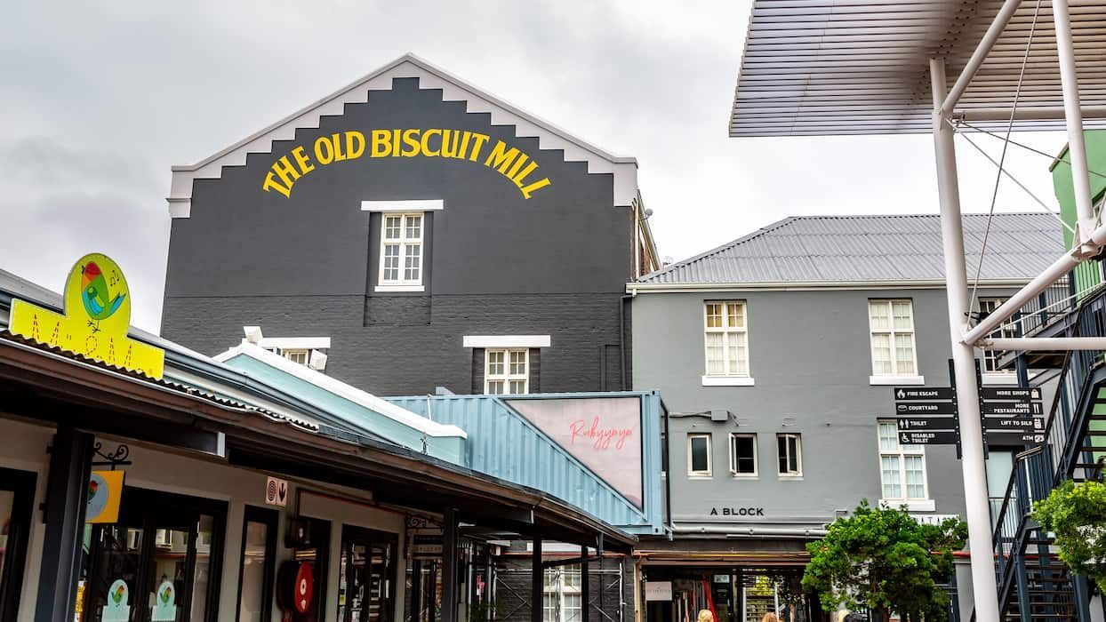
## Description The Old Biscuit Mill Market is one of Cape Town’s most recognizable weekend destinations because it combines food, design, shopping, and social energy in a way that feels distinctly local. Set in Woodstock, the market has a lively, urban character that sets it apart from coastal or postcard-style tourist attractions. People come here to eat well, browse creatively, and enjoy a scene that feels rooted in Cape Town’s contemporary culture. The market’s appeal lies partly in its setting. The Old Biscuit Mill itself is part of an industrial heritage landscape, which gives the whole area a textured, repurposed feel. That backdrop matters because it makes the experience feel more authentic than a generic pop-up market. You are not just walking through stalls. You are moving through a place where old industrial buildings have been adapted for a new city rhythm. One little-known fact is that the area helped shape Woodstock’s reputation as a creative and entrepreneurial neighborhood. Another is that the market often serves as a meeting point for both residents and visitors, which gives it a mixed energy that feels social without being superficial. Food is usually the biggest draw. You can find breakfast, brunch, fresh produce, artisanal products, baked goods, coffee, and a range of prepared dishes that reflect Cape Town’s diversity. But even if you arrive mainly for eating, it is worth staying long enough to explore the design and craft side too. Clothing, home goods, accessories, and small creative brands often make the market feel broader than a simple food hall. For visitors, the market works best as an experience rather than a quick stop. It is animated, busy, and best enjoyed when you are willing to browse, taste, sit down, and maybe circle back for another look. The energy is one of its strongest assets. On a good weekend morning, it feels like a concentrated snapshot of Cape Town’s urban lifestyle, with enough variety to satisfy both casual visitors and people who want to discover local makers. ## Location The Old Biscuit Mill Market is located in Woodstock, Cape Town, Western Cape, South Africa, in an area just east of the city center. Woodstock has become one of Cape Town’s most interesting urban districts, and the market sits within easy reach of the central business area as well as other inner-city neighborhoods. The simplest way to get there is by ride-hailing service, taxi, or private car. Parking may be available nearby, but a direct ride often makes the visit easier, especially on busy market days. If you are staying in central Cape Town, the journey is short enough that you can comfortably plan a morning visit and still have the rest of the day for other sights. Weekend visits are usually the sweet spot. The market is most alive then, and the surrounding neighborhood tends to feel especially active. Arriving earlier in the day gives you the best selection and the most breathing room before peak crowds build. ## Tips - Arrive early if you want the best food choices and a less crowded experience. - Bring both cash and card options, since different vendors may prefer different payment methods. - Start with food before shopping so you can explore without carrying too much. - Leave time to walk around Woodstock beyond the market itself. The neighborhood adds context to the visit. - If you are going with a group, agree on a meeting point because the market can get busy enough to split people up. ## Conclusion Old Biscuit Mill Market is one of Cape Town’s best places to spend a lively weekend morning, especially if you enjoy food, design, and a distinctly urban local atmosphere. It is casual, creative, and full of movement. ## FAQ ### Is the market only about food? No. Food is a major draw, but the market also includes design, crafts, and lifestyle shopping, which makes it broader and more interesting than a food-only venue. ### When is the best time to visit? Weekend mornings are usually best. That is when the market has the strongest energy and the widest range of visitors and vendors. ### Is it family-friendly? Yes. The market environment is social and lively, and families often find it easy to browse and eat there together. ### Can I visit if I am staying in central Cape Town? Definitely. Woodstock is close enough to make the market an easy half-day outing. ## Links - [Old Biscuit Mill official website](https://www.theoldbiscuitmill.co.za/)
GemVoyage Team • World
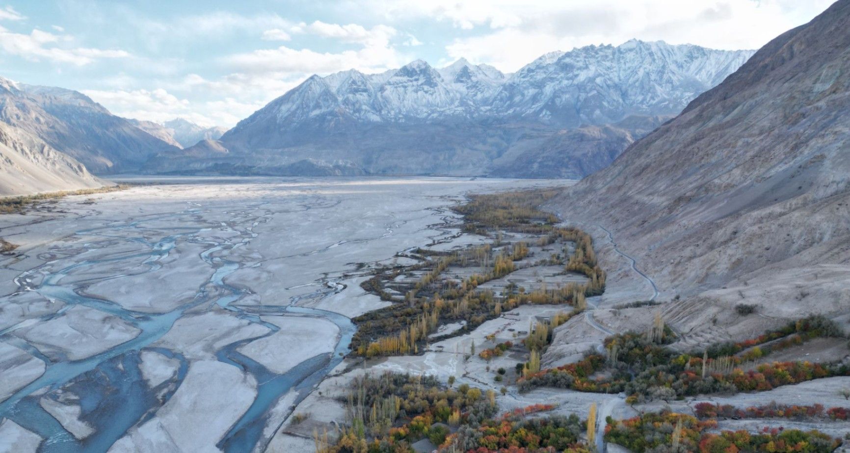
Pakistan
## Description **Nangma Valley**, located in northern Pakistan’s Gilgit-Baltistan region, is a breathtaking alpine valley that remains one of the country’s best-kept secrets. Renowned for its majestic granite spires, lush meadows, and pristine alpine landscapes, Nangma Valley is a paradise for trekkers, climbers, and photographers. What sets Nangma Valley apart is its untouched natural beauty and relative seclusion compared to more famous destinations like Hunza or Skardu. The valley is dotted with soaring rock towers—some over **5,000 meters** high—making it one of the premier destinations for **rock climbing and mountaineering** in Pakistan. Peaks such as **K7**, **K6**, and **Amin Brakk (the “Great Tower”)** have attracted world-class climbers from around the globe, yet the area still retains its peaceful, uncommercialized character. A lesser-known fact about Nangma Valley is that it is often referred to as **the “Yosemite of Pakistan”**, thanks to its sheer granite walls and the way sunlight paints the cliffs golden at dawn and dusk. The valley is also home to small Balti villages, where visitors can experience traditional hospitality and life in one of the most remote corners of the world. ## Location Nangma Valley lies in **Gilgit-Baltistan**, in the **Karakoram Range** of **northern Pakistan**, near the town of **Hushe** in the **Ghangche District**. It is about 130 kilometers east of **Skardu**, the main gateway to the region. To reach Nangma Valley, travelers first fly or drive to **Skardu**—flights from Islamabad are the most common route, taking about an hour (weather permitting). From Skardu, a scenic drive of approximately 5–6 hours leads to Hushe Village, from where the trek to Nangma Valley begins. The trek itself is moderate and usually takes around **3–4 hours** on foot, passing through alpine pastures and along a clear glacial stream. ## Tips * **Best time to visit:** The valley is most accessible between **June and September**, when the weather is mild, and the snow has melted. * **Pack for mountain weather:** Even in summer, temperatures can drop sharply at night. Warm layers and a sleeping bag are essential. * **Bring proper trekking gear:** Good hiking boots, walking poles, and waterproof clothing are highly recommended. * **Hire local guides and porters:** The Balti guides are knowledgeable about routes, weather, and local customs, and hiring them supports the local economy. * **Camping:** There are several scenic camping sites, such as at the base of Amin Brakk and near the Nangma Glacier. Always follow Leave No Trace principles. * **Photography:** Sunrise and sunset offer the best light for photographing the granite spires and surrounding peaks. * **Acclimatize properly:** Even though Nangma Valley is not at extreme altitude, gradual acclimatization helps prevent altitude sickness. ## Conclusion **Nangma Valley** is a hidden gem for those seeking adventure, solitude, and awe-inspiring mountain scenery. Its towering granite peaks, green meadows, and crystal-clear streams make it one of the most spectacular yet underexplored trekking destinations in Pakistan. Whether you’re an experienced climber or a nature lover looking for tranquility, Nangma Valley promises a journey deep into the heart of the Karakoram’s beauty and serenity. ## FAQ **1. Where is Nangma Valley located?** It’s in Gilgit-Baltistan, near Hushe Village in the Ghangche District, approximately 130 km from Skardu. **2. How do I reach Nangma Valley from Islamabad?** You can fly to Skardu (around 1 hour) or take a 20–22 hour drive via the Karakoram Highway. From Skardu, continue by jeep to Hushe and then trek into the valley. **3. Do I need a trekking permit?** No official permit is required for Nangma Valley itself, but registering with local authorities or the Hushe tourism office is recommended. **4. Is the trek difficult?** The trek to the main campsites is moderate, suitable for most fit travelers. Climbers aiming for higher peaks will need advanced equipment and experience. **5. Can I find accommodation nearby?** Basic guesthouses are available in Hushe Village. In the valley, visitors usually camp or stay in tents arranged by local guides. **6. Is Nangma Valley safe for tourists?** Yes. The valley is peaceful, and local communities are known for their warm hospitality. However, it’s best to travel with a guide and inform authorities of your plans. ## Links * [Pakistan Tourism Development Corporation](https://www.tourism.gov.pk) * [Adventure Pakistan – Trekking and Expeditions](https://www.adventurepakistan.com)
GemVoyage Team • World