GemVoyage Team • World
Perched high above the Canadian Rockies, Sky Bistro offers one of the most breathtaking dining experiences in Canada. Located at the summit of the Banff Gondola on Sulphur Mountain, this elegant yet relaxed restaurant combines world-class cuisine with panoramic views of six surrounding mountain ranges and the Bow Valley below.
The experience at Sky Bistro is about more than just food — it’s a sensory journey that connects visitors to the natural beauty of Banff National Park, a UNESCO World Heritage Site. The menu features locally inspired Canadian cuisine crafted with fresh, regional ingredients sourced from Alberta and British Columbia. Signature dishes often include bison, Arctic char, and wild mushrooms, all presented with a modern twist and paired with fine Canadian wines or craft beers.
What makes Sky Bistro particularly unique is its elevation — 2,281 meters (7,486 feet) above sea level — making it one of the highest dining spots in the country. A lesser-known fact is that the restaurant’s massive floor-to-ceiling windows were designed to reflect the colors of the surrounding peaks, minimizing environmental impact while maximizing views. Another delightful secret: if you time your reservation right, you can watch the sunset turn the Rockies golden before the night sky fills with stars — a truly unforgettable experience.
Sky Bistro sits at the summit of Sulphur Mountain in Banff National Park, Alberta, Canada, accessible only by the Banff Gondola. The gondola base station is located about 5 kilometers (3 miles) south of downtown Banff, on Mountain Avenue.
To reach the restaurant:
Reservations are highly recommended, especially during peak season (June–September) or for sunset dining.
Sky Bistro is where fine dining meets alpine adventure — a place where the grandeur of the Rockies enhances every bite. Whether you come for a romantic dinner, a special celebration, or simply to enjoy the incredible mountain views, this unique mountaintop restaurant delivers a dining experience that’s as memorable as the landscape itself. Sitting above the clouds, Sky Bistro captures the very essence of Banff: wild, beautiful, and unforgettable.
1. Where exactly is Sky Bistro located?
It’s at the summit of Sulphur Mountain in Banff National Park, accessible via the Banff Gondola from Mountain Avenue, Banff, Alberta.
2. Do I need a separate ticket for the gondola and the restaurant?
Yes, a gondola ticket is required to reach the summit. Some packages combine the gondola ride with a dining reservation for convenience and savings.
3. What kind of food does Sky Bistro serve?
The menu focuses on Canadian regional cuisine, featuring ingredients from across Alberta and Western Canada — including bison, salmon, elk, and seasonal produce.
4. Is Sky Bistro open year-round?
Yes, it operates year-round, though hours may vary depending on the season and weather conditions.
5. Can I visit Sky Bistro without a dining reservation?
Walk-ins are sometimes accepted during off-peak hours, but reservations are strongly recommended due to limited seating and high demand.
6. What’s the dress code?
Smart casual. While many guests come dressed for the mountain environment, a neat and tidy appearance is appropriate for dinner service.
7. Is it suitable for families?
Yes, children are welcome, and there are menu options suitable for younger guests.
Discover more hidden gems you might love.
Arizona
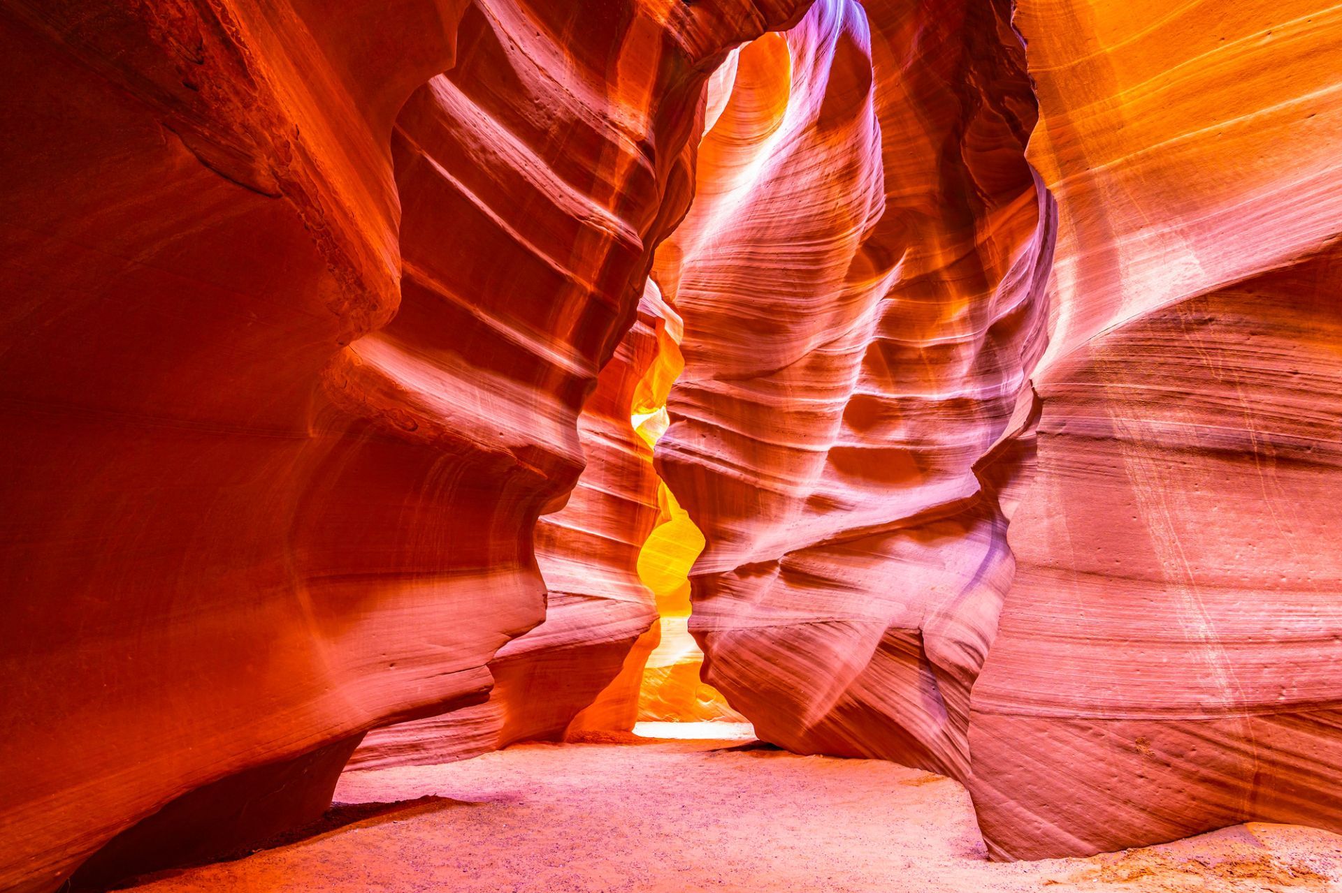
## Description Antelope Canyon, on Navajo land near Page, Arizona, is a set of narrow slot canyons carved into Navajo Sandstone by millennia of water and wind erosion. The result is a sequence of sinuous, polished walls that twist into narrow passages, channeling shafts of light into warm, copper-toned swirls that photographers prize. There are two main sections commonly visited: Upper Antelope Canyon (more iconic for vertical light beams in summer) and Lower Antelope Canyon (a more maze-like walk that requires climbing). The interplay of light, shadow and texture transforms the canyon’s interior into a living sculpture that changes with the sun’s angle. Antelope Canyon’s combination of geological finesse and cultural sensitivity makes it unique: it’s on Navajo Nation land and visits occur under Navajo guides who share cultural context and ensure conservation. The ephemeral quality of light in the canyon is the main draw, and every visit offers a subtly different visual story depending on time of day and season. Visiting Antelope Canyon is an intimate, often crowded experience that rewards patience and close observation. The sculpted walls are tactile and close, and the sense of enclosure makes small variations in light and dust dramatically affect composition. Guides routinely manage group flows and timing to optimize safety and photographic opportunity, and many operators now offer specialized photo tours that allow extra time or more flexible tripod policies. Safety is a constant priority — because slot canyons channel water, flash floods are a real hazard and tours may be altered or canceled in the face of storm risk. Respect for Navajo cultural protocols is also essential: guides often include stories and historical context that enrich a visit and reinforce why access is managed. Beyond the two main canyons, nearby attractions around Page — Horseshoe Bend, Lake Powell and Glen Canyon National Recreation Area — make the area a compact cluster of dramatic southwestern landscapes. Combining these sites into a short itinerary can balance the compressed, processed light of the slot canyons with broad, open panoramas of the Colorado River and surrounding desert. ## Location Antelope Canyon lies near Page, Arizona, in the southwestern United States on Navajo Nation land. The canyons are accessed by guided tours departing from Page; bookings are required, and many operators combine Antelope Canyon with nearby attractions like Horseshoe Bend and Lake Powell. Most tours meet in Page; travel to the canyon involves a short drive and, in some cases, a brief ride across Navajo lands to the canyon entrance. Tour operators coordinate closely with park officials and Navajo authorities; book in advance during peak seasons and confirm pickup details. Page has several accommodation options, from campgrounds to hotels, and is a good base for multi-day exploration of the region. ## Tips - **Book Navajo-guided tours:** Access to both Upper and Lower Antelope Canyons is restricted to authorized Navajo guides — book through reputable operators and respect cultural protocols. - **Time your visit for light:** For the classic light beams in Upper Antelope Canyon, mid-day in summer is preferred; other seasons offer softer, diffused light. - **Bring a tripod if allowed:** Some tours permit tripods (often in photo-specific sessions); check operator policies before arrival. - **Be mindful of flash floods:** Slot canyons can be hazardous during heavy rain; guides monitor weather and may cancel tours if flash flood risk exists. - **Protect your gear from sand:** The environment is dusty; use camera covers and clean gear after visits. - **Choose the right tour type:** Standard interpretive tours offer context and safety; photo tours are slower and often allow tripods but require advance booking. - **Expect narrow passages:** Lower Antelope requires more physical movement; wear comfortable clothes and be prepared to climb short ladders or squeeze through tight sections. - **Respect cultural guidance:** Photography of certain features or during ceremonies may be restricted — follow your guide's direction. - **Combine sites for variety:** Pair canyon visits with sunrise at Horseshoe Bend or a boat trip on Lake Powell to round out your visual narrative. ## Conclusion Antelope Canyon is a masterpiece of erosion and light — a place where sandstone artistry and cultural stewardship intersect to create intense photographic and contemplative experiences. Guided visits make it accessible while honoring its Navajo custodianship. Approach Antelope Canyon with curiosity and respect, and you’ll come away with a visceral appreciation for how water, time and human stewardship intersect. For photographers, the canyon is a study in subtle gradients and form; for travelers, it’s an opportunity to learn about the cultural landscape of the Navajo Nation while witnessing an extraordinary geological gallery. ## FAQ - **Q: Which is better, Upper or Lower Antelope Canyon?** - A: Upper is famed for light beams and is more accessible with level walks; Lower is narrower with ladders and a more adventurous feel. - **Q: Do I need a reservation?** - A: Yes — tours sell out, especially in peak season; book in advance. - **Q: Is Antelope Canyon wheelchair accessible?** - A: Accessibility varies: Upper has relatively easier access but still includes uneven surfaces; check specific operator accommodations. - **Q: Can I fly a drone near Antelope Canyon?** - A: Drone use is generally restricted in Navajo lands and near protected sites; check local rules and obtain permission where applicable. - **Q: What are the best months for photography?** - A: Summer delivers the strongest vertical beams around midday; spring and autumn provide softer light and cooler conditions, which many photographers prefer. - **Q: How long does a typical tour last?** - A: Standard canyon tours range from 45 minutes to 1.5 hours including access and return; photo tours may be longer. - **Q: Are there restrictions on clothing or equipment?** - A: Wear closed-toe shoes for lower canyon sections, protect gear from sand, and follow guide instructions for tripods or flash use. ## Links - [Antelope Canyon — Wikipedia](https://en.wikipedia.org/wiki/Antelope_Canyon) - [Navajo Nation Parks & Recreation](https://www.navajonationparks.org)
GemVoyage Team • World
Lima
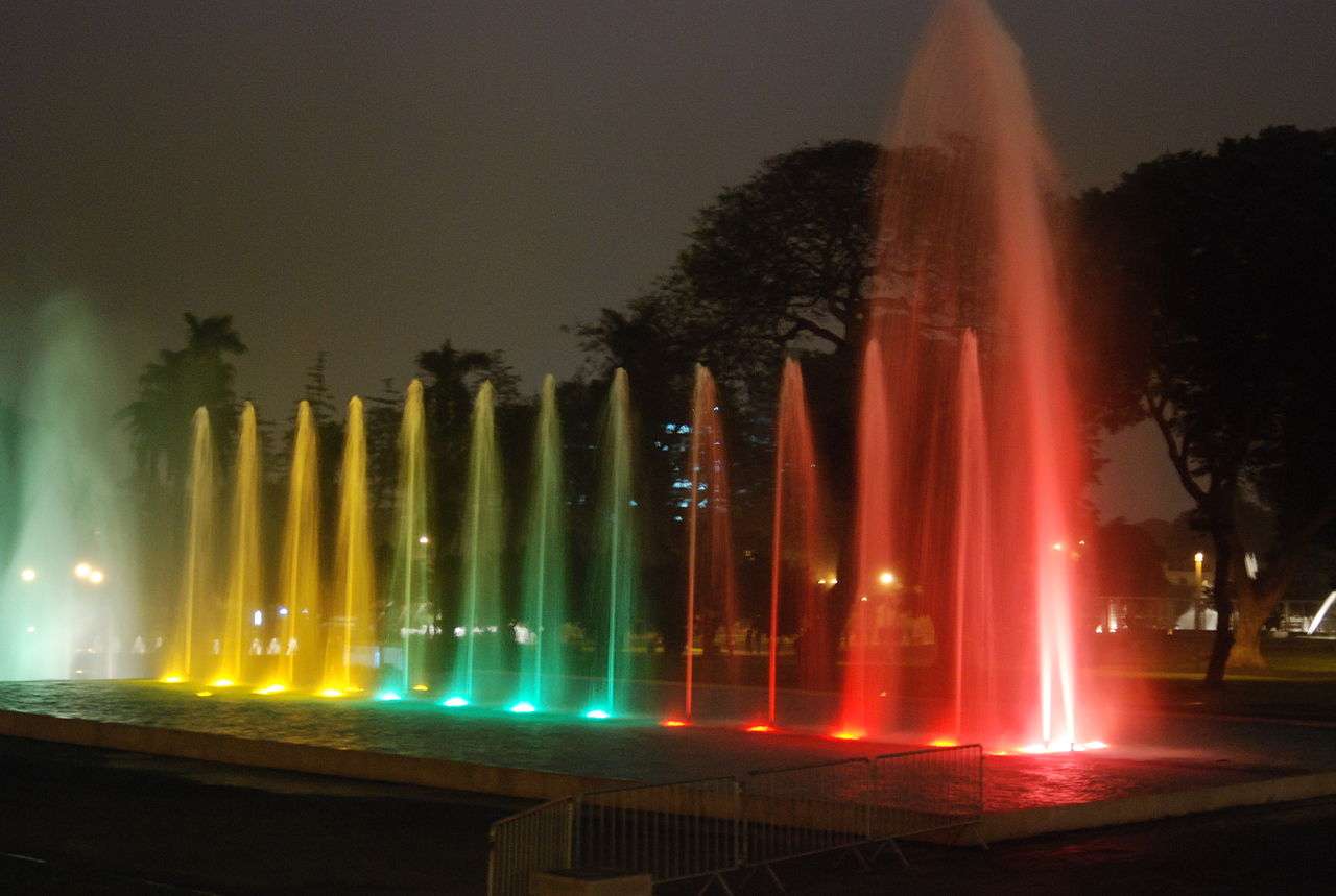
## Description The Magic Water Circuit (Circuito Mágico del Agua) in Lima is a dazzling display of light, music, and water that transforms a traditional city park into a nighttime spectacle. Located in the historic Parque de la Reserva, this attraction features 13 cybernetic fountains that combine cutting-edge technology with artistic choreography. Each fountain is uniquely designed, offering a blend of interactive experiences, visual storytelling, and cultural symbolism. The centerpiece of the park is the Fantasia Fountain, a 130-meter-long installation that hosts nightly multimedia shows. These performances blend water jets, laser lights, and music to create a captivating narrative—often highlighting Peruvian history, landscapes, and folklore. Other notable fountains include the Tunnel of Surprises, a 35-meter-long water tunnel that visitors can walk through, and the Dream Maze, where timing and agility are key to staying dry. A little-known fact: upon its opening in 2007, the Magic Water Circuit was recognized by the Guinness Book of World Records as the largest fountain complex in a public park. Another unique feature is the educational exhibits that occasionally accompany the fountains, such as historical photo displays or water conservation messages, adding depth to the entertainment. ## Location The Magic Water Circuit is located in **Peru**, in the **Lima Region**, within the **city of Lima**. Specifically, it sits in **Parque de la Reserva**, in the downtown district of Cercado de Lima. ### How to Get There - **By Taxi or Ride-Share**: Services like Uber and Cabify are widely available and can drop you off at the main entrance on Jr. Madre de Dios. - **By Public Transport**: The Metropolitano bus system stops nearby at Estación Central. From there, it’s a short walk to the park. - **By Foot**: If you're staying in central Lima, the park is easily accessible on foot from nearby neighborhoods like Jesús María or San Isidro. - **By Car**: Parking is available at the site, with flat rates depending on the lot. Its central location makes it a convenient stop for both tourists and locals exploring Lima’s cultural core. ## Tips - **Visit After Sunset**: The fountain shows begin around 7:15 PM and run multiple times throughout the evening. Arriving after dark ensures you catch the full spectacle. - **Bring a Rain Jacket or Poncho**: Some fountains are interactive, and you may get wet—especially in the maze or tunnel. - **Buy Tickets in Advance**: Entry is affordable (around S/5), but lines can form during weekends and holidays. Booking online or arriving early helps. - **Check for Special Events**: The park occasionally hosts themed shows or cultural exhibitions. Visit the official site for updates. - **Use a Tripod for Photos**: The lighting and water movement make for stunning photography, especially with long exposures. - **Respect the Rules**: Children under 5 enter free with ID, and discounts are available for seniors and people with disabilities. ## Conclusion The Magic Water Circuit in Lima is a vibrant fusion of art, technology, and public space. With its record-breaking fountains, immersive light shows, and family-friendly atmosphere, it offers a memorable evening experience that showcases the creative spirit of Peru’s capital. ## FAQ **1. What are the operating hours of the Magic Water Circuit?** The park is open daily from 3:00 PM to 10:00 PM. Multimedia shows begin at 7:15 PM, 8:15 PM, and 9:10 PM. **2. Is there an entrance fee?** Yes, general admission is S/5. Children under 5 enter free with ID. Discounts are available for seniors and people with disabilities. **3. Is the park suitable for children?** Absolutely. The interactive fountains and colorful displays are especially popular with families. **4. Can I bring food or drinks into the park?** Outside food is discouraged, but there are vendors and kiosks inside offering snacks and refreshments. **5. Are the shows in English or Spanish?** The multimedia shows are primarily visual and musical, with minimal spoken content, making them accessible to all visitors. **6. Is the park wheelchair accessible?** Yes, the park is designed to accommodate visitors with mobility needs, and discounted entry is available with proper ID. ## Links - [Official Magic Water Circuit Website](https://circuitomagicodelagua.pe/)
GemVoyage Team • World
Athens
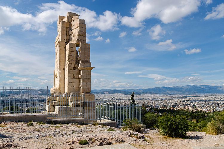
## Description Philopappos Hill is a quietly rewarding spot in Athens that combines green space, archaeological interest, and some of the city's best vantage points. Unlike the intensely visited Acropolis itself, Philopappos offers room to breathe: shaded paths, open lawns, and a prominent memorial monument that speaks to the city's Roman-era history. The hill is prized by locals and visitors looking for views, quiet reflection, and an approachable dose of history. Historically, the hill houses the Philopappos Monument, dedicated to Gaius Julius Antiochus Philopappos, a prominent figure in the Roman civic life of Athens. The site also preserves traces of long-term human use and offers a series of viewpoints that reveal the Acropolis from varied angles—useful for appreciating Athens' layered topography. The combination of nature and archaeology makes Philopappos ideal for a walk that complements more intense museum and monument visits. ## Location Philopappos Hill lies just southwest of the Acropolis in central Athens, within easy walking distance of the historic center. The hill's centrality means it can be folded into a broader exploration of the city's archaeological zones, museums, and neighborhoods such as Plaka and Thissio. Pathways connect the hill with other scenic spots, making it a natural link in a pedestrian-friendly sightseeing loop. Because some paths rise more steeply than others, sensible footwear and a modest level of mobility are helpful. The hill's proximity to major sites makes it an ideal stop for early morning or late afternoon visits when both light and temperature are more comfortable. ## Tips - Bring water, especially in summer—Athens' heat can make walks more strenuous. - Wear shoes with good grip for uneven or rocky paths. - Visit at sunrise or sunset for the best light and cooler temperatures. - Combine the hill with visits to the Acropolis, the Ancient Agora, and the neighborhoods of Plaka and Thissio. - Allow time to sit and take in the views rather than rushing through the paths. - Keep to marked routes and respect any archaeological conservation notices. ## Conclusion Philopappos Hill is an excellent complement to Athens' major monuments: quieter, greener, and full of viewpoints that help you see the Acropolis in context. It rewards visitors who seek slower sightseeing and panoramic perspectives. ## FAQ ### Why should I visit Philopappos Hill? Visit for quieter views of the Acropolis, a taste of Athenian green space, and the Philopappos Monument's historical resonance. ### How long does it take to explore? One to two hours is typical for a relaxed visit; longer if you plan to picnic or linger at viewpoints. ### Is it suitable for families? Yes—families who are comfortable with walking and light uphill sections will find it pleasant, though very young children may need supervision on uneven paths. ### Can I see the Acropolis from there? Yes—multiple viewpoints on the hill provide varied and informative perspectives of the Acropolis and surrounding city. ### Do I need a guide? Not strictly. The hill is easy to explore independently, though a guide can enrich the experience with historical context. ## Links - [Wikipedia](https://en.wikipedia.org/wiki/Philopappos_Monument)
GemVoyage Team • World
Berlin
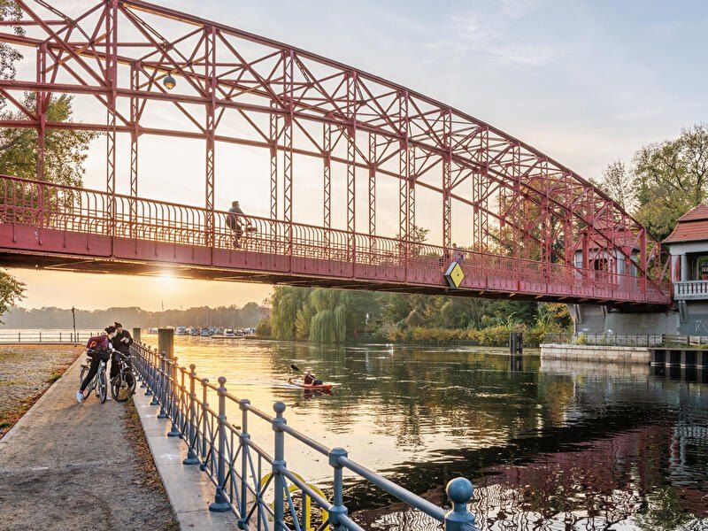
## Description **Tegeler See** is one of Berlin’s largest and most beloved lakes, offering a rare combination of **deep forest landscapes, wide open water, historic promenades, and recreational freedom** within a major European capital. Unlike the carefully curated parks of central Berlin, Tegeler See feels **expansive, natural, and quietly powerful**, a place where the city dissolves into wind, water, and tree canopy. The lake stretches across the northern edge of Berlin and forms part of a much larger **interconnected water system** linking rivers, canals, and smaller lakes. Its shoreline alternates between **elegant promenades, dense woodland, sandy bathing areas, hidden coves, and small harbors**, giving every section a distinct character. On one walk you might pass joggers and cyclists near cafés, and moments later find yourself alone on a forested shoreline with only birds and passing sailboats for company. What makes Tegeler See especially unique is its **scale and visual openness**. The lake is wide enough to feel almost coastal in certain sections. Wind patterns shape large ripples across the surface, and on clear days the sky reflects endlessly into the water. Sailboats, paddleboards, kayaks, ferries, and swimmers all share the same space, creating an ever-moving ecological and recreational system. The western and northern edges of the lake are bordered by the **Tegel Forest (Tegeler Forst)**, one of Berlin’s largest continuous woodland zones. This forest contains long hiking paths, wildlife corridors, thick pine stands, and historic hunting routes that once served Prussian royalty. This direct interface between **urban lake and protected forest** is one of Tegeler See’s defining strengths. Few European capitals offer this scale of natural immersion without leaving city limits. From an urban perspective, the lake is closely tied to the borough of **Reinickendorf** and the historic district of **Alt-Tegel**. The Alt-Tegel promenade along the eastern shoreline functions as a social spine, lined with restaurants, ice cream shops, boat docks, beer gardens, and terraces overlooking the water. This area transforms in summer into one of Berlin’s most relaxed outdoor social scenes, blending families, cyclists, couples, and long-term residents. A little-known fact is that Tegeler See was once part of the **Havel River’s natural floodplain system**, and its modern form is the result of long-term hydraulic engineering dating back centuries. Another lesser-known detail is that the famous German poet and philosopher **Gotthold Ephraim Lessing** once lived near the lake, and the nearby Tegel Palace was home to the Humboldt family, including **Alexander von Humboldt**, one of history’s most influential natural scientists. Tegeler See’s emotional identity is shaped by **seasonality**. In spring, the forest releases fresh green layers and migrating birds return. Summer brings swimming, paddleboarding, lakeside dining, and long evening sunsets. Autumn covers the surrounding hills in gold and copper tones. Winter transforms the lake into a minimalist landscape of cold light, mist, and silence, occasionally frozen at the edges. Unlike Berlin’s central landmarks, Tegeler See does not present itself as a destination of spectacle. Its appeal is built on **duration rather than intensity**. People do not come for a single photo; they come to spend hours walking, reading, boating, cycling, swimming, and simply existing beside water and forest. It is one of the few places in Berlin where **time visibly slows down**. In a city often defined by density, history, and cultural pressure, Tegeler See functions as a **pressure valve**. It absorbs excess motion and releases calm. ## Location **Tegeler See** is located in **northwestern Berlin**, primarily within the borough of **Reinickendorf**, near the historic district of **Tegel**. **City:** Berlin **State (Region):** Berlin **Country:** Germany **Primary Area:** Reinickendorf / Alt-Tegel ### How to Get There: * **By S-Bahn:** * Take **S25** to **Tegel Station**, then walk 10 minutes to the lakeside. * **By U-Bahn:** * Take **U6** to **Alt-Tegel**, which places you directly at the main promenade. * **By bus:** Multiple bus routes connect Tegel with central and northern Berlin. * **By bicycle:** A well-developed bike network connects Tegeler See to the city center. * **By car:** Parking is available but is limited on busy summer days. The lake is easily combined with visits to **Alt-Tegel old town, Tegel Forest hiking trails, and the Havel River network**. ## Tips * **Visit on weekdays if you prefer quiet:** Weekends can be very busy in summer. * **Walk both the promenade and the forest side:** Each offers a completely different experience. * **Bring swimwear in summer:** Designated bathing areas are popular and well maintained. * **Sunset is the most atmospheric time:** Especially from western shoreline viewpoints. * **Boat rentals are widely available during the warm season.** * **Dress for wind:** The open water creates noticeable temperature shifts. * **Combine with Alt-Tegel dining:** Lakeside restaurants are a core part of the experience. * **Winter visits are underrated:** The silence and mist create a dramatic, cinematic mood. ## Conclusion **Tegeler See** is Berlin at its most expansive and elemental. It is where the city trades architecture for horizon, traffic for water movement, and density for breathing space. By uniting forest, lake, promenade, and history into one continuous landscape, Tegeler See offers a version of Berlin that is **slower, wider, and deeply restorative**. ## FAQ **1. Is Tegeler See suitable for swimming?** Yes. Several **official bathing areas** operate during the summer season. **2. Can you rent boats on Tegeler See?** Yes. **Paddleboats, kayaks, and small sailboats** are available for rent. **3. Is Tegeler See family-friendly?** Yes. It is widely used by **families, cyclists, walkers, and swimmers**. **4. How long does it take to walk around Tegeler See?** Walking the full perimeter can take **2.5 to 4 hours**, depending on pace and route. **5. Is Tegeler See good in winter?** Yes, especially for **quiet walks, photography, and forest exploration**. **6. Is there wildlife around the lake?** Yes. The area supports **water birds, foxes, deer, and diverse forest species**. ## Links * [Visit Berlin](https://www.visitberlin.de)
GemVoyage Team • World
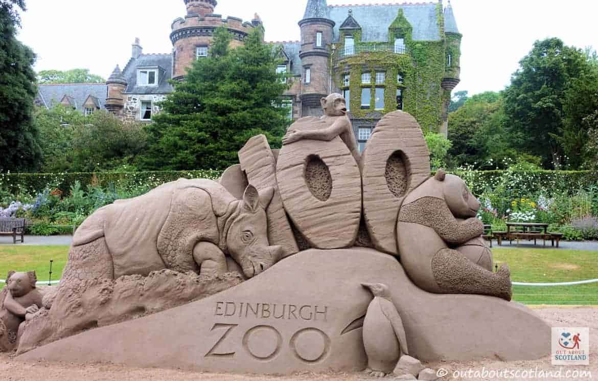
Edinburgh
## **Description** Edinburgh Zoo is one of Europe’s most respected zoological parks and a highlight for animal lovers visiting the British Isles. Although it is sometimes mistakenly referred to as being in Ireland, **Edinburgh Zoo is actually located in Scotland**, just a short flight or ferry journey away from Ireland, making it a popular add-on destination for travelers exploring nearby countries. What makes Edinburgh Zoo truly unique is its strong focus on conservation, education, and animal welfare. Home to over 1,000 animals representing more than 150 species, the zoo is internationally recognized for its successful breeding programs, particularly for endangered species. One little-known fact is that Edinburgh Zoo was the **first zoo in the world to house and successfully breed penguins**, which is why it remains especially famous for its large and lively penguin colony. Another fascinating detail is that the zoo is built on **Corstorphine Hill**, giving visitors sweeping panoramic views of Edinburgh city alongside animal exhibits. Unlike many traditional zoos, the enclosures are designed to mimic natural habitats as closely as possible, allowing animals to behave more naturally while offering visitors a more immersive experience. ## **Location** Edinburgh Zoo is located in **Scotland, United Kingdom**, within the city of **Edinburgh**, in the **Corstorphine area**. It sits approximately three miles west of Edinburgh city center. For visitors coming from Ireland, the easiest way to get there is by taking a **direct flight from Dublin, Cork, or Belfast to Edinburgh Airport**, which is less than 20 minutes away from the zoo by taxi or bus. Alternatively, travelers can take a ferry from Ireland to Scotland or England and continue by train to Edinburgh. Public buses run frequently from the city center and stop directly outside the zoo entrance, making transportation simple and convenient. ## **Tips** * **Arrive early** to enjoy popular animal talks and feeding sessions, especially the penguin parade. * **Wear comfortable shoes**, as the zoo is spread across a hillside and involves a fair amount of walking. * **Check the daily schedule** online before visiting to plan your day around keeper talks and special events. * **Bring layers or waterproof clothing**, as Scottish weather can change quickly. * **Allow at least four to five hours** to explore the zoo at a relaxed pace. * **Visit on weekdays** if possible to avoid crowds, especially during school holidays. ## **Conclusion** Edinburgh Zoo is a must-visit attraction for anyone traveling near Ireland or across the UK. With its strong conservation mission, unique hillside setting, and iconic penguin colony, it offers an enriching and memorable experience for visitors of all ages. ## **FAQ** **Is Edinburgh Zoo located in Ireland?** No, Edinburgh Zoo is located in Scotland, United Kingdom. It is often visited by travelers from Ireland due to its close proximity. **How long does it take to visit Edinburgh Zoo?** Most visitors spend between four and five hours exploring the zoo. **Is Edinburgh Zoo suitable for children?** Yes, the zoo is very family-friendly and offers interactive exhibits, play areas, and educational talks. **What is Edinburgh Zoo most famous for?** The zoo is best known for its penguin colony and its global conservation efforts. **Can I reach the zoo by public transport?** Yes, several buses run directly from Edinburgh city center to the zoo entrance. ## **Links** * [Official Edinburgh Zoo Website](https://www.edinburghzoo.org.uk)
GemVoyage Team • World
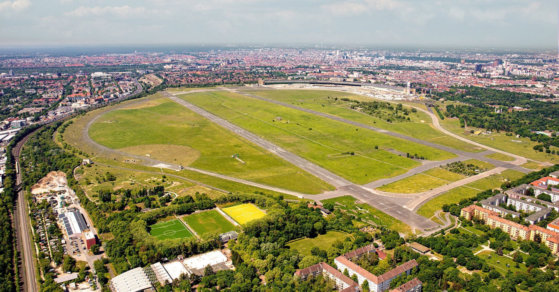
Berlin
## Description Tempelhofer Feld is one of Berlin's most unusual public spaces, and perhaps one of the most extraordinary urban parks in Europe. Built on the site of the former Tempelhof Airport, the area preserves a sense of scale that is rare in any city. Instead of dense landscaping or ornamental design, visitors are met with immense open runways, broad skies, and wide horizons that make the park feel almost cinematic. It is a place where Berlin's history, civic imagination, and appetite for public space come together in a striking way. What makes Tempelhofer Feld unique is how many different activities it can support without ever feeling crowded. Cyclists, skaters, runners, families, kite flyers, gardeners, and people simply sitting in the grass all share the space comfortably because it is so large. The former airport infrastructure is still visible in many places, which adds a sense of industrial memory to the recreational experience. You are not just visiting a park; you are walking through a piece of 20th-century urban history that has been repurposed for contemporary life. One little-known fact is that Tempelhof's runways and hangars helped shape the modern meaning of the site long before it became a park, and the airport itself became a powerful symbol during the Berlin Airlift. Another is that the area is often used for community gardens and events, making it both open and socially active rather than simply passive green space. That mix of openness and civic use is part of why Berliners defend the field so strongly. The atmosphere changes throughout the day. In the morning it can feel calm and almost meditative, with joggers tracing long loops beneath big skies. In the afternoon it becomes more playful, with people flying kites, practicing sports, or meeting friends for picnics. Sunset is particularly memorable because the flat openness gives you an unobstructed view of the light changing across the field. Tempelhofer Feld also tells a broader story about Berlin's identity. The city is often associated with reinvention, and this site embodies that idea without erasing the past. Rather than demolish every trace of the airport, Berlin turned the space into an active commons. For visitors, that means the park is both relaxing and intellectually interesting, especially if you enjoy places where landscape and history overlap. If you want one destination that shows how Berlin handles scale, memory, and public access, Tempelhofer Feld is hard to beat. It is not decorative in the traditional sense, but it is deeply satisfying because it gives you room to move, think, and experience the city in a different register. ## Location Tempelhofer Feld is located in southern-central Berlin, Germany, on the grounds of the former Tempelhof Airport. It lies in the Tempelhof-Schöneberg district and is easy to reach from several parts of the city. The most convenient ways to get there are by U-Bahn, S-Bahn, or bicycle, depending on where you are staying. Several entrances serve the park, and once inside, the flat terrain makes it easy to orient yourself. Because the space is large, choosing the entrance closest to your planned activity can save time. ## Tips Bring water and weather protection. The openness that makes the field special also means it can be windy or exposed to strong sun. If you like cycling or skating, Tempelhofer Feld is one of the best places in Berlin for it because the former runways offer long, smooth stretches. Do not expect a landscaped park with many shaded paths. The design is intentionally open, so plan for a more minimalist experience. Visit during golden hour or sunset if you want the strongest visual impression. Check the park rules before arrival, especially if you plan to use a drone, barbecue, or special equipment. Set aside enough time to walk farther than you think. The scale of the field is part of the experience. ## Conclusion Tempelhofer Feld is a rare urban park that turns a former airport into a vast public landscape, offering freedom, history, and an unmistakably Berlin sense of scale. ## FAQ ### Can you still see the airport at Tempelhofer Feld? Yes, much of the airport's structure and runway layout remains visible, which is part of the site's appeal. ### Is Tempelhofer Feld good for families? Yes, families often enjoy the open space, though you should bring what you need because there are no dense park facilities everywhere. ### Is there an entrance fee? The park itself is generally free to enter. ### What is the best way to experience it? Walking, cycling, or simply spending time on the open grass are all good ways to appreciate the space. ## Links - [Tempelhofer Feld](https://www.tempelhoferfeld.de/)
GemVoyage Team • World


Comments