GemVoyage Team • World
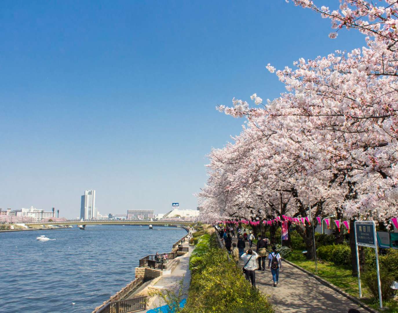
Sumida Park is a serene riverside oasis in the heart of Tokyo, offering a refreshing contrast to the city’s fast-paced urban energy. Stretching along both banks of the Sumida River, the park is located between the Azumabashi and Sakurabashi bridges and provides stunning views of the Tokyo Skytree rising above the skyline. It’s a favorite spot for locals and tourists alike, especially during spring when the park transforms into one of Tokyo’s most celebrated cherry blossom viewing locations.
The park’s history dates back to the Edo period, when the riverbanks were popular gathering spots for hanami (cherry blossom viewing), festivals, and leisurely strolls. Today, Sumida Park continues that tradition with over 600 cherry trees lining the paths, creating a tunnel of blossoms that draws thousands of visitors each year. In summer, the park becomes a prime viewing location for the Sumida River Fireworks Festival, one of Japan’s oldest and most spectacular pyrotechnic displays.
A little-known fact: the cherry trees in Sumida Park were planted under the orders of shogun Tokugawa Yoshimune in the 18th century, making the park not only a natural retreat but also a living piece of Tokyo’s cultural heritage. Another quirky detail is the nearby Asahi Beer Tower, visible from the park, which was designed to resemble a frothy mug of beer—a playful architectural nod to the area’s modern flair.
Sumida Park is located in Japan, in the Kanto region, within the city of Tokyo. It spans the Taito and Sumida wards, with entrances near the historic Asakusa district and the Sumida River waterfront.
Its central location makes it a convenient stop during a day of sightseeing in eastern Tokyo.
Sumida Park is a tranquil yet culturally rich destination in Tokyo, offering scenic river views, seasonal beauty, and a deep connection to the city’s history. Whether you're admiring cherry blossoms, watching fireworks, or simply enjoying a quiet walk, the park provides a memorable escape in the heart of the metropolis.
1. Is there an entrance fee to Sumida Park?
No, the park is free and open to the public year-round.
2. When is the best time to visit Sumida Park?
Spring (late March to early April) for cherry blossoms and summer (late July) for the fireworks festival.
3. Are there restrooms and facilities in the park?
Yes, there are public restrooms and seating areas throughout the park.
4. Can I bring pets to Sumida Park?
Yes, pets are allowed but should be kept on a leash and cleaned up after.
5. Is the park wheelchair accessible?
Most paths are flat and accessible, though some areas may have uneven terrain.
6. Are there guided tours available?
While not specific to the park, many Asakusa walking tours include Sumida Park as part of their itinerary.
Discover more hidden gems you might love.
Taiwan
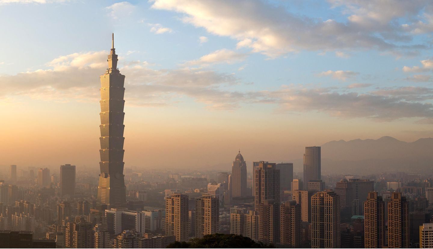
## Description **Lansheng Tower (攬勝樓)** is a traditional scenic pavilion in Taiwan, valued less for monumental scale and more for its **symbolic role as a viewpoint** designed to frame the surrounding landscape. True to its name, which translates roughly as “Tower for Taking in the Scenery,” Lansheng Tower embodies a classic East Asian architectural concept where the structure exists primarily to enhance the appreciation of nature rather than dominate it. Typically built in a **classical Chinese pavilion style**, Lansheng Tower features an elevated platform, open sides, and a tiled roof supported by wooden columns. This design allows uninterrupted views while providing shade and shelter, making it an ideal resting point for walkers, hikers, and photographers. The tower is often integrated into a park, riverside walk, or hillside trail, where it serves as a visual anchor and a quiet pause within the landscape. A lesser-known aspect of Lansheng Tower is its cultural role as a **literary and contemplative space**. Such towers were traditionally associated with poetry, calligraphy, and scholarly gatherings, and inscriptions or plaques are sometimes displayed to commemorate local history or notable figures. Another interesting detail is that the location was often chosen based on principles of **feng shui**, emphasizing balance between water, elevation, and surrounding landforms. Rather than being a destination that demands long hours, Lansheng Tower rewards visitors who value stillness, perspective, and subtle beauty. It represents a distinctly Taiwanese approach to public space, blending heritage architecture with everyday life. ## Location **Country:** Taiwan **Region:** East Asia **City:** Location varies depending on the specific Lansheng Tower, as the name is used for scenic pavilions in parks or natural areas Lansheng Tower is typically found within a **public park, scenic area, or hillside viewpoint**, often overlooking rivers, lakes, or city skylines. ### How to Get There * **By public transport:** * MRT or local buses usually stop near the park or scenic area where the tower is located. * **On foot:** * Many towers are reached via walking paths or short hiking trails. * **By taxi or ride-hailing:** * A convenient option if the tower is located in a less central area. * **By bicycle:** * In urban parks or riverside areas, cycling paths often lead directly to the site. ## Tips * **Visit during sunrise or sunset:** The tower’s purpose is scenic viewing, and lighting conditions matter. * **Bring a camera or sketchbook:** The elevated views are ideal for photography and drawing. * **Check the weather:** Clear days offer the best visibility, especially if the tower overlooks water or mountains. * **Respect the space:** These pavilions are often used for quiet rest and reflection. * **Combine with a walk:** Lansheng Tower is best experienced as part of a longer stroll or hike. * **Read any plaques or inscriptions:** They often provide historical or cultural context that enriches the visit. ## Conclusion Lansheng Tower is a modest but meaningful landmark that reflects Taiwan’s cultural appreciation for scenery, balance, and contemplation. Rather than impressing through size or grandeur, it invites visitors to slow down, observe, and connect with the surrounding environment from a thoughtfully chosen vantage point. ## FAQ **1. What does Lansheng Tower mean?** The name translates roughly to “Tower for Enjoying the View.” **2. Is there an entrance fee?** No. Scenic pavilions like Lansheng Tower are usually free to access. **3. How long should I stay?** Most visitors spend **15–30 minutes**, longer if combining it with a walk or photography. **4. Is it suitable for children and elderly visitors?** Yes, provided the access path is flat or gently sloped. **5. Is it historically important?** While not always ancient, it follows traditional architectural and cultural principles rooted in Chinese and Taiwanese heritage. **6. Can I visit at night?** Some locations are accessible at night, but lighting varies. Safety depends on the surrounding area. ## Links * [Taiwan tourism portal](https://www.taiwan.net.tw)
GemVoyage Team • World

Los Angeles
## Description Abbot Kinney Boulevard in Venice, Los Angeles, is a short but influential thoroughfare celebrated for its creative retail scene, independent restaurants, and a distinctive local aesthetic that has become synonymous with modern, small-scale urban cool. Stretching for just a few blocks, Abbot Kinney packs an outsized cultural punch: curated boutiques, artisanal homewares, specialty coffee shops, and innovative dining concepts sit shoulder-to-shoulder with galleries and pop-up markets. The boulevard’s identity is rooted in a "local-first" ethos. Many shops are owner-operated and feature limited-run or locally produced goods, which gives the area an artisanal sensibility that contrasts with more commercial shopping districts. Over the years Abbot Kinney has become a preferred destination for designers, food entrepreneurs and creative-makers who favor a human-scale retail environment where craftsmanship and storytelling matter. Events like "First Fridays" and seasonal street fairs amplify the boulevard’s community mood, with extended shop hours, live music and curated pop-ups that draw both locals and visitors. For food lovers, the avenue is a laboratory of contemporary culinary trends: casual but refined bakeries, modern vegan eateries, and chef-driven bistros can all be found within a short walk. Side streets and upper-floor venues often hide some of the area’s best-kept secrets — intimate bars, tiny galleries, and rooftop patios — rewarding those who slow down and explore. Abbot Kinney also serves as a hub connecting Venice’s broader cultural assets: the nearby beach, historic canals, street art corridors and the bustling Venice Boardwalk are all within easy reach, making the boulevard an ideal stop on a full-day itinerary. Buying categories and sustainability: shoppers can expect to find distinct clusters along the boulevard — homewares and design shops, independent fashion boutiques, specialty food producers, and lifestyle stores focused on wellness. Many retailers emphasize sustainable sourcing and limited production runs; if ethical purchasing matters to you, look for small labels and ask about materials and production methods. ## Location Abbot Kinney Boulevard runs through the Venice neighborhood of Los Angeles, approximately between Ocean Avenue near the beach and Lincoln Boulevard inland. Its central location makes it accessible from Santa Monica, Marina del Rey and other nearby neighborhoods. Getting there: driving is often the fastest option but parking can be limited; consider using parking apps, arrive early, or use nearby paid lots. Multiple bus routes serve Venice, and rideshares or bike rentals are popular alternatives. From Santa Monica or the Marina, cycling along dedicated paths is a pleasant way to arrive and enjoy the waterfront scenery. ## Tips - Visit on weekday mornings for quieter browsing and the best chance to chat with shop owners. - Explore side streets: many of Abbot Kinney’s best cafes and galleries are tucked away from the main strip. - Check store hours: many boutiques open mid-morning and close earlier than big-box retailers, so plan accordingly. - Reserve tables for popular restaurants during weekends and evenings, especially for dinner. - Bring a reusable bag and embrace the local eco-friendly ethos; some shops minimize packaging. - Wear comfortable shoes: although the area is walkable, you’ll want to wander both main and side streets. - Bring a camera and leave space for small, meaningful purchases rather than impulse-heavy shopping. ## Conclusion Abbot Kinney Boulevard distills Venice’s eclectic, creative spirit into a compact, walkable experience. Whether you’re shopping for thoughtful design pieces, sampling new culinary concepts, or simply watching the neighborhood pulse, the boulevard delivers a layered portrait of community-driven urban life. ## FAQ Q: Is Abbot Kinney family-friendly? A: Yes. The area is walkable and casual during the day, with family-friendly cafes and shops. Evening hours can be livelier and more adult-focused, so plan accordingly. Q: How do I find parking near Abbot Kinney? A: Parking is limited on-street; look for paid lots, use parking apps, or consider rideshares and public transit to avoid circling for spaces. Q: When is First Fridays and what is it? A: First Fridays is a monthly event (check local listings for exact dates) where shops extend hours, pop-ups appear and live music is common. It’s a popular time to experience the boulevard’s community energy. Q: Are the shops expensive? A: The mix includes accessible boutiques and higher-end designer stores. Many shops sell locally made, limited-run items that reflect artisanal production which can influence prices. Q: Are dogs welcome? A: Many cafes and stores are dog-friendly, but policies vary; always check individual shop rules before bringing a pet inside. ## Links - [Abbot Kinney Blvd Official Site](https://www.abbotkinneyblvd.com)
GemVoyage Team • World
Istanbul
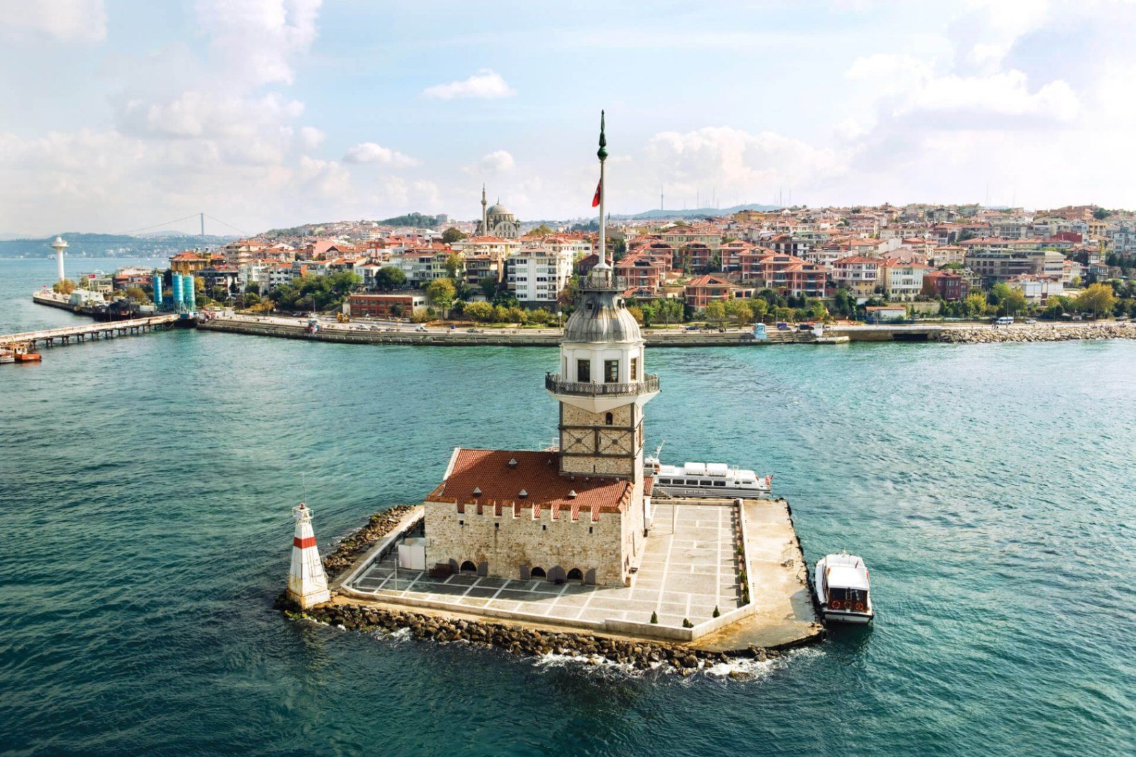
## Description **Maiden’s Tower (Kız Kulesi)** is one of Istanbul’s most recognizable and symbolically charged landmarks, standing alone on a small islet in the Bosphorus Strait. Neither fully Asian nor European in spirit, the tower embodies Istanbul’s identity as a city suspended between worlds. Its silhouette, visible from both shores, has inspired legends, poetry, paintings, and countless interpretations over centuries. The structure’s history stretches back to **antiquity**, with the earliest known use dating to the 5th century BCE, when it functioned as a defensive outpost controlling maritime traffic entering the Bosphorus. Over time, the tower has served many roles: lighthouse, customs checkpoint, quarantine station, watchtower, and even a radio transmission point. Each era left its mark, making the tower less a single-purpose monument and more a **layered historical artifact**. What truly distinguishes Maiden’s Tower is the **mythology surrounding it**. The most famous legend tells of a princess locked inside the tower to protect her from a prophecy foretelling her death by snakebite—only for the prophecy to come true regardless. Another lesser-known tale connects the tower to **Hero and Leander**, linking it symbolically to tragic love stories from classical antiquity. These narratives, though not historically verifiable, have become inseparable from the site’s identity. A little-known fact is that the tower has been **rebuilt multiple times**, most recently during the Ottoman period and again in modern restorations, meaning what visitors see today is the result of careful reconstruction rather than a single intact ancient structure. Another overlooked detail is that its strategic placement allowed it to work in tandem with towers on both shores, forming a maritime control system rather than functioning in isolation. Today, Maiden’s Tower operates primarily as a cultural and leisure site, offering exhibitions, a café, and panoramic views that rival any viewpoint in the city. ## Location **Country:** Turkey **Region:** Marmara **City:** Istanbul **District:** Üsküdar **Waterway:** Bosphorus Strait The tower sits just off the Asian shore of Istanbul, opposite the historic peninsula and close to Üsküdar’s coastline. ### How to Get There * **By ferry or boat:** * Small boats depart regularly from **Üsküdar** and sometimes from **Kabataş** on the European side. * **By public transport:** * Take Marmaray, metro, or ferry lines to Üsküdar, then walk to the departure pier. * **By taxi:** * Taxi to Üsküdar waterfront, then transfer by boat. Access to the tower is only possible by boat; swimming or private access is prohibited. ## Tips * **Visit near sunset:** The views of the Bosphorus and historic skyline are at their best. * **Check restoration status:** Access may vary due to maintenance or cultural programming. * **Book in advance during peak seasons:** Boats and entry slots can fill quickly. * **Dress for wind:** The tower is exposed, especially on upper levels. * **Combine with Üsküdar exploration:** The surrounding district offers mosques, promenades, and cafés. * **Manage expectations:** The tower is small; the experience is about atmosphere, not scale. ## Conclusion Maiden’s Tower is less about architectural grandeur and more about symbolism, location, and continuity. Standing alone in the Bosphorus, it captures Istanbul’s layered history and enduring fascination better than almost any other single structure. ## FAQ **1. Is Maiden’s Tower ancient?** Its origins date back over 2,000 years, but the current structure reflects multiple reconstructions. **2. Can you go inside the tower?** Yes, when open to the public, visitors can enter via boat. **3. How long does a visit take?** Typically **30 to 60 minutes**, excluding boat travel. **4. Is there an entrance fee?** Yes, pricing varies depending on exhibitions and services. **5. Is it better to visit during the day or evening?** Evening visits are more atmospheric, especially around sunset. **6. Is the tower wheelchair accessible?** Accessibility is limited due to stairs and the historic structure. ## Links * [Istanbul official tourism portal](https://istanbul.com)
GemVoyage Team • World

Nürnberg
## Description The **Nürnberg Zoo and Dolphinarium** (Tiergarten Nürnberg) in Germany is one of the most fascinating zoological gardens in Europe, combining a rich natural setting with modern animal care facilities. Spread over **67 hectares of forest and meadowland**, this zoo offers visitors the unique experience of observing animals in spacious enclosures that closely resemble their natural habitats. Unlike many urban zoos, Nürnberg Zoo is nestled within a former sandstone quarry, giving the park a very scenic and distinctive landscape. What makes Nürnberg Zoo particularly unique is its **Dolphinarium**, which opened in 1971 and remains one of the few dolphinariums in Germany. It is home to bottlenose dolphins and manatees, and it has a strong focus on research, conservation, and educational programs. The zoo is internationally recognized for its breeding successes with endangered species such as the manatee, snow leopard, and Siberian tiger. A little-known fact about Nürnberg Zoo is that it houses **Europe’s only Aqua Park for dolphins** connected directly to a lagoon system, providing a near-natural environment for the marine mammals. Another interesting fact is that the zoo was originally founded in 1912, making it over a century old, though it had to be rebuilt after World War II due to heavy destruction. ## Location The Nürnberg Zoo and Dolphinarium is located in **Nuremberg (Nürnberg), Bavaria, Germany**. The zoo lies in the eastern part of the city, in a wooded area that gives it a peaceful and natural atmosphere. * **Country:** Germany * **Region:** Bavaria (Bayern) * **City:** Nuremberg (Nürnberg) ### How to Get There Visitors can reach the zoo easily by **public transportation**. From Nuremberg’s city center, take tram line 5 or bus line 65, which stop directly at the entrance of the zoo. For international visitors, the nearest airport is **Nuremberg Airport (NUE)**, located only about 13 km away. If you are driving, there is ample parking space near the entrance. For an eco-friendly option, cycling through the scenic routes of Nuremberg to the zoo is also recommended. ## Tips To make the most of your visit to Nürnberg Zoo and Dolphinarium, here are some useful tips: 1. **Plan Enough Time** – The zoo covers a vast area, so allow at least half a day, ideally a full day, to explore both the zoo and the Dolphinarium. 2. **Check Show Times** – The dolphin presentations are the highlight of the visit. Be sure to check the schedule in advance so you don’t miss it. 3. **Wear Comfortable Shoes** – With its hilly terrain and large grounds, comfortable walking shoes are a must. 4. **Bring Snacks or Enjoy Local Food** – While the zoo has restaurants and snack stations, bringing your own picnic is also a great option. 5. **Visit the Children’s Zoo** – Families with young kids will love the petting area where children can interact with farm animals. 6. **Best Seasons to Visit** – Spring and summer are particularly pleasant, as many animals are more active outdoors and the lush greenery makes the park extra beautiful. --- ## Conclusion The **Nürnberg Zoo and Dolphinarium** is more than just a zoo—it is a unique blend of history, nature, and modern animal conservation. With its scenic landscape, rare animal species, and one of Germany’s only dolphinariums, it offers a memorable experience for visitors of all ages. Whether you’re a family with children, an animal enthusiast, or simply a traveler exploring Bavaria, this attraction is well worth a visit. --- ## FAQ **1. How long should I plan for a visit to Nürnberg Zoo?** Most visitors spend between **4 to 6 hours** exploring the zoo and enjoying the dolphin shows. **2. Is the Dolphinarium included in the zoo ticket price?** Yes, admission to the Dolphinarium is included in the **general zoo entrance fee**. **3. Can I bring food and drinks into the zoo?** Yes, visitors are welcome to bring their own food and enjoy a picnic in designated areas. **4. Is Nürnberg Zoo open all year round?** Yes, the zoo is open daily, including weekends and holidays. However, opening hours may vary by season. **5. What animals can I see at Nürnberg Zoo?** The zoo is home to over **300 animal species**, including dolphins, manatees, snow leopards, polar bears, and Siberian tigers. --- ## Links * [Official Nürnberg Zoo Website](https://tiergarten.nuernberg.de) * [Tourist Information for Nuremberg](https://tourismus.nuernberg.de)
GemVoyage Team • World
Beijing
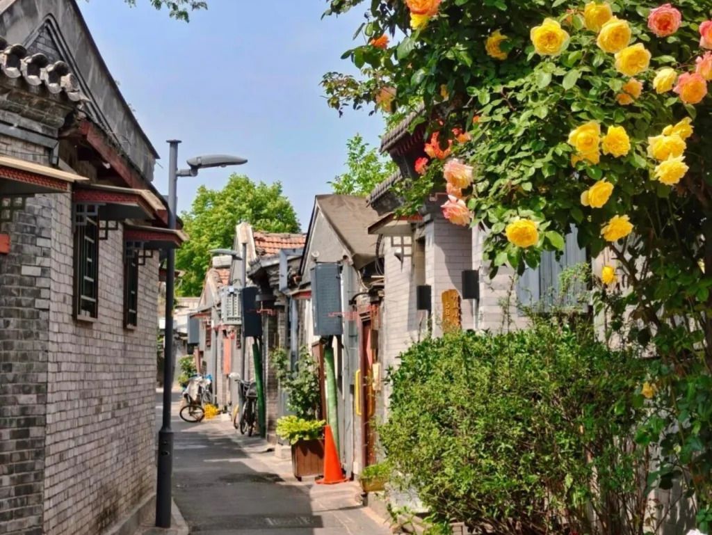
## Description Qinhuangdao Alley Hutongs, as a travel idea, points to one of Beijing’s most rewarding urban experiences: moving through the city’s traditional hutong lanes and seeing how historic residential fabric still shapes everyday life. Hutongs are not grand monuments in the usual sense. They are narrow lanes, courtyard-house networks, and neighborhood corridors that preserve a more intimate view of Beijing than the city’s large avenues and famous landmarks. That is exactly why they remain so compelling. They let visitors step into the scale of older Beijing, where community, domestic life, and street activity sit in close proximity. The appeal of the hutong experience lies in its texture. Instead of one single iconic object, you get layered details: gray brick walls, courtyard entrances, hand-painted signs, hidden cafés, neighborhood shops, bicycles, small temples, and the daily rhythm of residents going about ordinary routines. A lesser-known fact is that hutongs are not just tourist curiosities; they are living urban forms that have survived because they still support local life, even as some areas have changed dramatically. Another overlooked detail is that many of the most interesting hutong walks reveal small architectural differences from lane to lane, including gate styles, courtyard layouts, and adaptations made over time to fit modern use. If you are traveling in Beijing for the first time, hutongs can be one of the most useful experiences you choose because they explain the city in a human-scale way. They show how neighborhoods are organized, how people move, and how history remains present without always announcing itself loudly. Unlike large museums, the hutong district does not ask you to stand still. It invites you to wander, notice, and compare. That makes it especially rewarding for slow travelers, photographers, architecture lovers, and anyone who prefers atmosphere over checklist sightseeing. The name “Qinhuangdao Alley Hutongs” may be used locally or descriptively, but the broader experience belongs firmly to Beijing’s historic center. Rather than approaching it as a single fenced attraction, think of it as a neighborhood exploration. That mindset will help you appreciate it much more fully. ## Location The hutong experience is centered in Beijing Municipality, China, especially in the older districts of Dongcheng and Xicheng where historic lanes remain most visible. Depending on the exact lane or alley you plan to visit, you may be close to landmarks such as Shichahai, Nanluoguxiang, the Bell and Drum Towers, or other traditional neighborhoods. Because hutongs are embedded in the city’s fabric, their location is best understood as a district-level experience rather than a single destination pin. Getting there is usually easiest by subway, followed by a short walk. Beijing’s public transit network is efficient for reaching the historic core, and once you exit the station, the pleasure comes from entering the smaller lanes on foot. Taxis and rideshares are also practical, but traffic can make them slower than the metro during busy hours. If you prefer a more immersive approach, combine subway access with a walking route that allows for detours into side streets. Because the exact lanes can be harder to define than a single monument, it helps to visit with an open itinerary. Choose a starting point in a known hutong district and then let the side alleys guide your exploration. That approach usually produces the most interesting results. ## Tips Walk slowly. Hutongs reward attention to detail, and many of their best moments are found between the obvious sights. Respect private space. These are living neighborhoods, not theme park sets, so it is important to be considerate when taking photos or peering into courtyards. Visit at a comfortable time of day. Morning and late afternoon often feel more pleasant for walking, with softer light and a calmer pace. Combine the walk with food. Small noodle shops, tea spots, and casual eateries can turn a simple stroll into a much richer cultural experience. Do not try to “finish” the hutongs. The value is in wandering a manageable section well, not in covering everything. ## Conclusion The hutongs of Beijing offer one of the most atmospheric ways to understand the city. They are historic, living, and quietly beautiful, with enough variation to reward curiosity at every turn. For travelers who want Beijing beyond its headline monuments, this is an essential experience. ## FAQ ### What is a hutong? A hutong is a traditional Beijing alley or lane, usually linked to courtyard-house neighborhoods. The form reflects older patterns of urban life and remains an important part of the city’s identity. ### Are hutongs still inhabited? Yes. Many hutong areas are still lived in, even though some have been renovated, adapted, or repurposed for commerce and tourism. ### Is this more of a walking experience than a fixed attraction? Exactly. Hutongs are best understood as a walkable neighborhood environment rather than a single enclosed site. ### How long should I spend there? A focused walk might take 1 to 2 hours, but a more rewarding visit can easily stretch longer if you stop for food, tea, or photography. ## Links - [Hutong on Wikipedia](https://en.wikipedia.org/wiki/Hutong) - [Beijing official tourism](https://english.beijing.gov.cn/)
GemVoyage Team • World

Graz
## Description **Basilika Mariatrost** is the most important pilgrimage church in the region of Styria and one of the most visually striking religious landmarks in Graz. Perched on a hill overlooking the eastern edge of the city, the basilica is a masterpiece of **Austrian Baroque architecture**, instantly recognizable by its twin towers and commanding elevated position. More than a place of worship, it represents centuries of faith, healing traditions, and regional identity. Construction of the basilica began in the early 18th century under the patronage of the Pauline Order, following reports of miraculous healings associated with a statue of the Virgin Mary. The church was intentionally built high above the surrounding landscape, reinforcing its role as a spiritual refuge removed from everyday life. Its grand staircase—over 200 steps long—adds a sense of ritual to the approach, turning the journey itself into part of the pilgrimage experience. Inside, the basilica is richly decorated with frescoes, gilded altars, and intricate stucco work. The high altar frames the revered **Marian statue**, the spiritual heart of the church. One lesser-known fact is that the church temporarily lost its religious function during Emperor Joseph II’s reforms in the late 18th century and was repurposed before later being restored as a pilgrimage site. Another notable detail is that Mariatrost was elevated to the status of a **minor basilica** by the Vatican in 1999, recognizing its historical and spiritual significance. Despite its religious importance, Basilika Mariatrost is also appreciated for its **panoramic views**, serene atmosphere, and harmonious integration with the surrounding greenery. It attracts pilgrims, architecture enthusiasts, photographers, and visitors seeking quiet contemplation. ## Location **Country:** Austria **Region:** Styria **City:** Graz **District:** Mariatrost The basilica is located in the **northeastern part of Graz**, on a wooded hill that rises above the Mariatrost district. ### How to Get There * **By tram:** * Take **Tram Line 1** from Graz city center to the final stop, **Mariatrost**. From there, it is a short walk to the basilica. * **On foot:** * Walking routes and pilgrimage paths lead uphill from the tram stop. * **By car:** * Accessible by local roads, with limited parking available nearby. * **By bicycle:** * Possible for experienced cyclists, though the ascent can be steep. ## Tips * **Climb the staircase at least once:** It enhances the sense of arrival and offers changing views. * **Visit in the morning or late afternoon:** The light is softer, and the atmosphere is quieter. * **Dress respectfully:** The basilica is an active place of worship. * **Attend a service if possible:** Music and acoustics add depth to the experience. * **Combine with a walk:** The surrounding area has pleasant walking paths and forest trails. * **Photography is best outside:** Interior photography may be restricted during services. ## Conclusion Basilika Mariatrost is both a spiritual landmark and an architectural highlight of Graz. Its elevated position, Baroque elegance, and centuries-old pilgrimage tradition make it a meaningful destination for visitors seeking history, culture, and calm above the city. ## FAQ **1. Why is Basilika Mariatrost important?** It is the most significant pilgrimage church in Styria, centered around devotion to the Virgin Mary. **2. Is there an entrance fee?** No. Entry to the basilica is free. **3. How long should I plan for a visit?** Around **45 minutes to 1.5 hours**, depending on whether you attend a service or explore the surroundings. **4. Is the basilica accessible for people with limited mobility?** Yes, though the main staircase is steep; alternative access routes are available. **5. Can tourists visit during services?** Yes, but visitors should remain respectful and avoid photography. **6. What is the best time of year to visit?** Spring and early autumn offer pleasant weather and clear views. ## Links * [Official Graz tourism site](https://www.graztourismus.at)
GemVoyage Team • World

Comments