GemVoyage Team • World
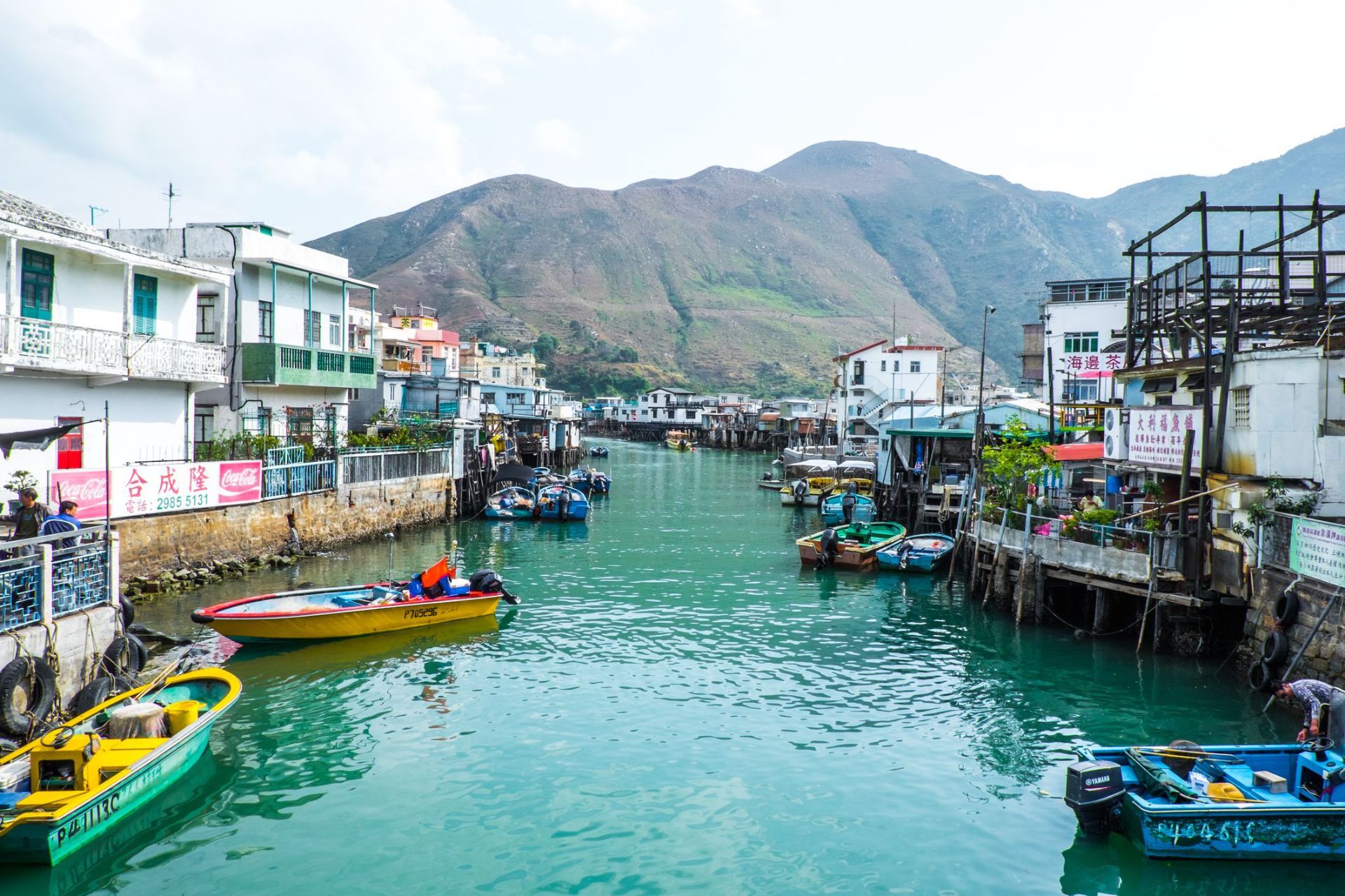
The village is especially distinctive because it has kept much of its fishing-community layout, even as Hong Kong developed around it. The stilt houses, built above tidal waters and connected by wooden walkways, create a visual landscape that is unique in the region. Boat traffic still matters here, seafood is still central to the local economy, and the village still feels shaped by the rhythms of sea and tide. In the early morning, Tai O can feel hushed and contemplative. Later in the day, it becomes more animated as day visitors arrive, shops open, and boats move in and out of the channels.
A little-known fact is that Tai O has long been associated with salt production and trade, not just fishing. Another detail many visitors miss is the old village fortifications and temple structures that reflect how communities once protected themselves from pirates, storms, and the uncertainties of coastal life. The area is therefore not simply picturesque; it is historically layered and reveals a deeper story about how people adapted to Hong Kong's shoreline before modern development changed the coastline.
The food here is another major reason to visit. Dried seafood, shrimp paste, sweet treats, and simple local dishes are part of Tai O’s identity, and they help visitors understand how the village economy worked for generations. Even if you only spend half a day here, Tai O can feel like a complete change of pace from the rest of Hong Kong, offering a mixture of water, heritage, and community that is increasingly rare.
The usual route is to travel by MTR to Tung Chung and then continue by bus toward Tai O. This combination is the most practical for most visitors and gives you a smooth connection from the city’s main transport network. Ferries and cable car routes may also be part of a longer day trip if you are combining Tai O with other parts of Lantau Island. If you prefer a more relaxed pace, many travelers visit as part of a full-day itinerary that includes Ngong Ping and the Big Buddha before continuing to Tai O in the afternoon.
Once you arrive, much of the village is best explored on foot, though local boat rides are a memorable way to see the stilt houses from the water. Because the village is compact, it is easy to cover the main areas without rushing, but you should allow extra time for food stops, photographs, and slow wandering.
Take a boat ride if your schedule allows. Seeing Tai O from the water gives you a better sense of how the stilt houses, waterways, and fishing infrastructure fit together. It also helps explain why the village developed the way it did. If you only walk the streets, you still get a strong impression, but the boat perspective adds depth.
Try local snacks and dried seafood, but do so with curiosity rather than haste. Many travelers rush through Tai O, take a few photos, and leave without understanding the food culture that has shaped the village for years. Sampling something local makes the visit more meaningful.
Wear comfortable shoes and bring sun protection. Tai O is relatively easy to walk, but the experience is more enjoyable when you are prepared for heat, humidity, and a fair amount of time outdoors. If the weather looks unstable, check conditions before you go, since coastal villages are more sensitive to storms and heavy rain.
Discover more hidden gems you might love.
Cairo
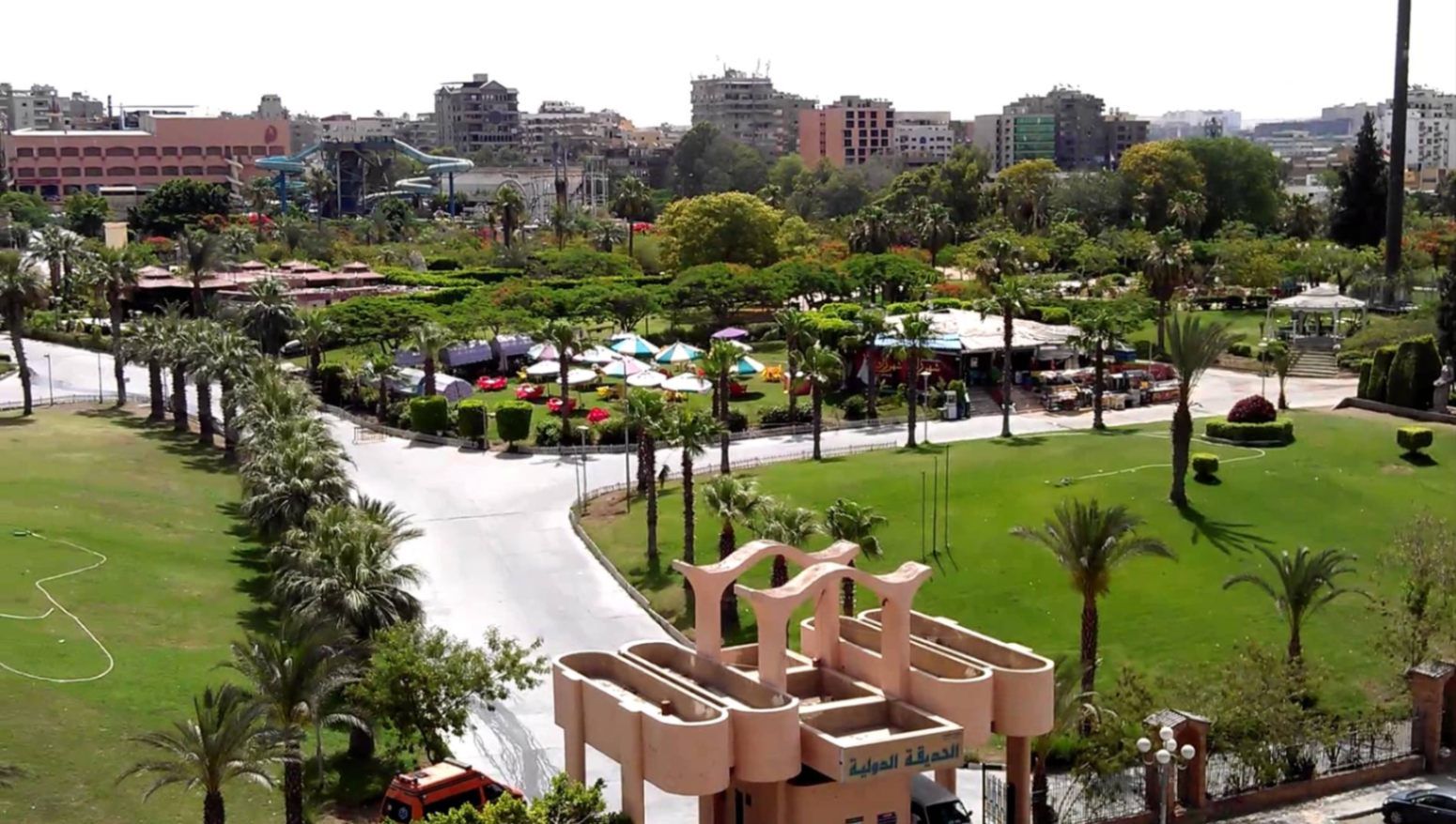
## Description **The International Park (الحديقة الدولية بالقاهرة)** is one of Cairo’s most distinctive public green spaces, designed to showcase a miniature journey through different countries and cultures within a single park. Established in the late 1980s, the park was conceived as a cultural and recreational project where landscaped areas, architectural replicas, and themed gardens represent nations from around the world. While not polished in the way of modern theme parks, its charm lies in its **ambitious concept, open space, and local atmosphere**. What makes the International Park unique is its layout: each section is inspired by a different country, featuring symbolic structures, sculptures, plants, or design elements associated with that nation. Visitors can walk from Asian-inspired pavilions to European-style gardens within minutes. This eclectic mix gives the park an almost nostalgic quality, reflecting Cairo’s vision of internationalism during the late 20th century. A lesser-known fact is that several embassies and cultural institutions contributed ideas or symbolic elements during the park’s early development, even if execution varied over time. Another interesting detail is that the park was once a major venue for **school trips and cultural festivals**, making it an important part of collective memory for many Cairenes who grew up in the 1990s. Today, the park functions primarily as a **family-friendly recreational space**. It is popular for picnics, casual walks, and affordable outings, especially for residents of eastern Cairo. While some areas show signs of aging, the park’s size, greenery, and concept still make it a refreshing escape from the dense urban environment. ## Location **Country:** Egypt **Region:** Greater Cairo **City:** Cairo **District:** Nasr City The International Park is located in **Nasr City**, one of Cairo’s largest residential districts, close to major roads and residential compounds. ### How to Get There * **By taxi or ride-hailing:** * Uber and local taxis are the most convenient option from anywhere in Cairo. * **By car:** * Easily accessible via Nasr City’s main roads, with parking available near the entrance. * **By public transport:** * Microbuses and buses serving Nasr City pass close to the park, though routes can be confusing for first-time visitors. * **From central Cairo:** * Expect a 30–45 minute drive depending on traffic. ## Tips * **Visit in the afternoon:** Late afternoon offers better weather and softer light, especially in warmer months. * **Bring your own food:** Picnic areas are common, and outside food is usually allowed. * **Wear comfortable shoes:** The park is large, and exploring all sections involves significant walking. * **Manage expectations:** Some country sections are more symbolic than detailed replicas. * **Good for children:** Open spaces allow kids to run freely, and the atmosphere is relaxed. * **Avoid peak public holidays:** The park can become crowded during major Egyptian holidays. ## Conclusion The International Park is a spacious, culturally themed green retreat that offers a simple but enjoyable experience for families and casual visitors. Its global concept, combined with its local character, makes it a nostalgic and accessible escape from Cairo’s urban intensity. ## FAQ **1. When was the International Park opened?** It was established in the late 1980s as a cultural and recreational project. **2. Is there an entrance fee?** Yes, there is a low entrance fee, making it affordable for families. **3. How long should I plan for a visit?** Most visitors spend **1.5 to 3 hours**, depending on walking pace and activities. **4. Is the park suitable for tourists?** Yes, especially for those interested in local leisure spaces rather than major monuments. **5. Are there food stalls inside?** Basic snacks may be available, but bringing your own food is recommended. **6. Is it good for photography?** Yes, particularly for casual photography and wide shots of greenery and themed structures. ## Links * [Egyptian tourism portal](https://www.experienceegypt.eg/en)
GemVoyage Team • World
Faro
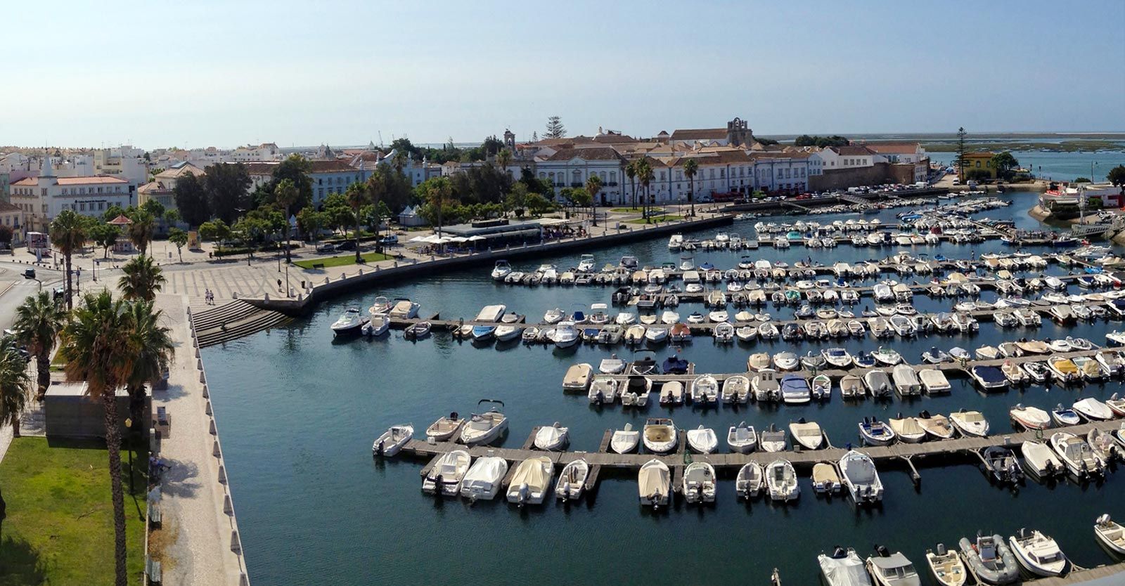
## Description Faro Marina is one of the most picturesque and lively spots in the Algarve region of southern Portugal. Nestled right in the heart of Faro, the marina is a central meeting point where the city’s charm blends seamlessly with its maritime heritage. With a backdrop of palm trees, elegant architecture, and rows of yachts and fishing boats bobbing gently on the water, it’s a place that embodies the relaxed yet vibrant spirit of coastal Portugal. What makes Faro Marina unique is not only its stunning scenery but also its role as a **gateway to the Ria Formosa Natural Park**, one of Portugal’s most beautiful protected lagoons. Many boat tours depart from the marina, offering visitors the chance to explore secluded islands, birdwatch, or enjoy a relaxing cruise at sunset. A little-known fact about Faro Marina is that the **large stork nests perched on lampposts and rooftops** around the harbor are a common sight, adding to its charm and making it a favorite spot for photographers. Another interesting detail is that the marina is often used for cultural events and festivals, turning it into a lively gathering point during summer evenings. ## Location Faro Marina is located in **Faro, the capital of the Algarve region in Portugal**. It sits right by the **city center**, just across from the historic old town and within walking distance of landmarks such as the **Arco da Vila** and **Faro Cathedral**. Its central location makes it a natural starting point for exploring both the city and the Algarve coastline. ### Recommendation on How to Get There From **Faro Airport**, the marina is only about a **10-minute drive** or a 15-minute bus ride on the airport shuttle. If you’re arriving by train or bus, both stations are within a short walking distance of the marina. For those exploring the Algarve by car, Faro is well-connected by road, and public parking is available near the city center. ## Tips Here are some helpful tips to make your visit to Faro Marina memorable: * **Take a Boat Tour**: Don’t miss the opportunity to explore the Ria Formosa islands, such as Ilha Deserta or Ilha do Farol, by booking a boat tour directly from the marina. * **Enjoy a Sunset Drink**: The waterfront is lined with cafés and bars—perfect for enjoying a glass of Portuguese wine or a cocktail while watching the sun go down. * **Photography Spot**: Bring your camera, especially for capturing the boats, the palm-fringed promenade, and the storks nesting nearby. * **Combine With Old Town Visit**: Since the marina is next to Faro’s historic district, combine your visit with a walk through cobbled streets, museums, and churches. * **Best Time to Visit**: Early evening is ideal, as the marina lights up beautifully, and the temperature is more comfortable during warmer months. * **Look Out for Events**: During summer, concerts, markets, and festivals are often held at or near the marina, adding extra vibrancy to your visit. ## Conclusion Faro Marina is more than just a harbor—it’s a cultural and social hub that captures the essence of Faro and the Algarve. With its stunning waterfront views, lively atmosphere, and easy access to natural wonders like the Ria Formosa, it’s a must-visit spot for anyone traveling to southern Portugal. Whether you’re taking a boat tour, enjoying a drink by the water, or simply strolling along the promenade, Faro Marina is sure to leave a lasting impression. ## FAQ **1. What can I do at Faro Marina?** You can enjoy boat tours to the Ria Formosa islands, dine at waterfront cafés, attend local events, or simply relax and admire the views. **2. Is Faro Marina close to the city center?** Yes, it’s located in the heart of Faro and is within walking distance of the historic old town and main transport hubs. **3. Are boat tours available year-round?** Yes, although availability and schedules may vary depending on the season. Summer offers the widest selection of tours. **4. Is it family-friendly?** Absolutely. The marina is pedestrian-friendly and offers plenty of open space, making it great for families with children. **5. Can I see wildlife at the marina?** Yes, you’ll often spot storks nesting nearby, and boat tours will take you to the Ria Formosa lagoon, which is rich in birdlife. **6. How long should I plan to spend at Faro Marina?** A casual visit might take an hour, but if you’re combining it with a boat trip and old town exploration, plan for half a day or more. ## Links * [Official Faro Tourism Office](https://www.faro.pt/en)
GemVoyage Team • World
Dublin
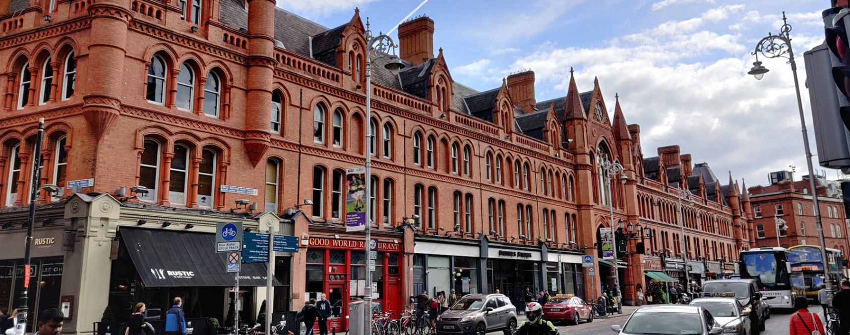
## Description **George’s Street Arcade (Stiúrtha Shráid Sheoirse)** is one of **Dublin’s oldest and most beloved shopping destinations**, offering a delightful blend of history, culture, and creativity. Opened in **1881**, it is one of the earliest purpose-built shopping arcades in Europe and remains a vibrant hub for both locals and visitors. Housed within a beautifully restored **Victorian red-brick structure**, the arcade features high wrought-iron arches, decorative glass roofing, and an atmosphere that blends the old with the contemporary. Inside, the narrow aisles are lined with an eclectic mix of independent stalls and boutique shops selling everything from vintage clothing and handmade jewelry to records, art, books, and collectibles. Street food vendors and cafés add delicious aromas to the air, making the experience as sensory as it is cultural. What makes George’s Street Arcade unique is its **authentic local character**—unlike chain-filled shopping centers, this market has remained fiercely independent for more than a century. It survived a major fire in 1892 and was rebuilt within two years, preserving its original charm. Another lesser-known fact is that the arcade was designed by English architects Lockwood & Mawson, the same team behind the iconic City Hall in Bradford, England. ## Location George’s Street Arcade is located in the heart of **Dublin City Centre**, **Ireland**, on **South Great George’s Street**, between Dame Street and Drury Street. Its central position places it just a few minutes’ walk from popular landmarks such as **Grafton Street**, **Trinity College**, and **Temple Bar**. To get there: * **On foot:** If you’re already exploring the city center, the arcade is within easy walking distance of most attractions. * **By public transport:** Take the **Luas Green Line** to the St. Stephen’s Green stop, or use Dublin Bus routes that pass through Dame Street or Aungier Street. * **By car:** Parking is available at nearby car parks such as Drury Street Car Park, though walking or public transport is recommended due to limited city parking. ## Tips * **Visit in the morning or early afternoon:** Crowds are smaller, and shop owners often have time to chat and share stories about their wares. * **Bring cash:** While many stalls accept cards, some smaller traders prefer cash for quick transactions. * **Try local snacks:** Sample treats from the market cafés — popular picks include crepes, pastries, or locally roasted coffee. * **Look for vintage and handmade goods:** The arcade is known for its one-of-a-kind finds, especially clothing, vinyl, and jewelry. * **Photography tip:** The interior’s glass roof and iron arches make for stunning photos, especially when sunlight filters through the skylights. * **Explore nearby:** After your visit, stroll along South William Street or George’s Street for more indie boutiques, pubs, and street art. ## Conclusion **George’s Street Arcade** is a living piece of Dublin’s history — a place where Victorian architecture meets contemporary creativity. Whether you’re shopping for a unique souvenir, enjoying local food, or simply soaking in the lively ambiance, this market captures the essence of Dublin’s independent spirit. It’s not just a shopping destination; it’s an experience that connects the city’s past with its ever-evolving present. ## FAQ **1. When was George’s Street Arcade built?** It was originally opened in 1881 and rebuilt in 1894 after a devastating fire. **2. What can I buy there?** The arcade offers handmade crafts, vintage fashion, jewelry, books, vinyl records, art, souvenirs, and local food. **3. Is there an entrance fee?** No, entry to the arcade is free for all visitors. **4. What are the opening hours?** Typically open **Monday to Saturday from 9:30 a.m. to 6:00 p.m.** and **Sunday from 12:00 p.m. to 6:00 p.m.**, though hours can vary slightly by shop. **5. Can I find local Irish products?** Yes — many vendors sell handcrafted Irish goods, from Celtic jewelry and wool accessories to local artwork and artisan foods. **6. Is it wheelchair accessible?** Yes, the main entrances and interior walkways are accessible, though some smaller stalls may have tight spaces. ## Links * [Official George’s Street Arcade Website](https://www.georgesstreetarcade.ie) * [Visit Dublin – George’s Street Arcade](https://www.visitdublin.com)
GemVoyage Team • World
Copenhagen
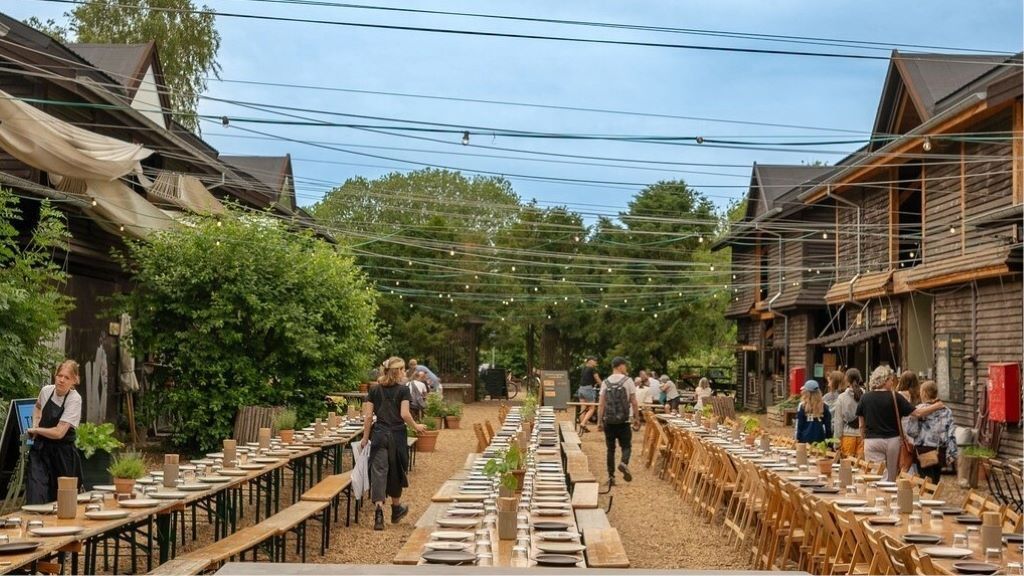
## Description **Banegaarden** is one of Copenhagen’s most compelling examples of **urban regeneration through food, culture, and sustainability**. Built inside a former railway maintenance area, this vibrant cluster of wooden buildings, green courtyards, bakeries, breweries, eateries, and cultural spaces has been transformed into a **community-driven gastronomic village** that blends industrial heritage with contemporary Nordic creativity. What makes Banegaarden truly distinctive is its **organic, low-rise village layout** rather than a typical food hall or marketplace structure. Ten restored wooden railway buildings form the heart of the site, connected by gravel paths, gardens, fire pits, and outdoor seating areas. Instead of polished glass and steel, the visual language here is **raw wood, brick remnants, reclaimed beams, and soft green landscaping**. The result feels more like a countryside craft settlement dropped into the city than a traditional urban development. Food is the central magnet, but Banegaarden is not built around fast consumption. Many of its kitchens focus on **seasonal Nordic ingredients, organic produce, fermented foods, sourdough baking, slow-roasted meats, and local craft beer and natural wine**. Several of the food operators also function as production spaces, meaning visitors can see bread baked, beer brewed, and ingredients processed on-site. This transparency reinforces the project’s emphasis on **craft, traceability, and sustainability**. Equally important is Banegaarden’s **cultural layer**. The site frequently hosts live music, vinyl listening sessions, workshops, farmers’ markets, food talks, and small festivals. These activities transform the area from a dining destination into a **living social platform** that evolves with the seasons. Summer brings long outdoor evenings around communal tables, while winter focuses on indoor gatherings, candles, and fire-lit courtyards. A key characteristic of Banegaarden is its **anti-commercial atmosphere**. There is no corporate branding dominance, no chain restaurants, and no sterile shopping-mall layout. Instead, it operates more like a **curated creative ecosystem** where craftsmen, chefs, farmers, brewers, musicians, and designers coexist. This gives the place an authenticity that is difficult to manufacture and easy to lose in large-scale redevelopment projects. A little-known fact is that the site originally functioned as a **railway service yard for inspecting and repairing trains**, not as a public passenger area. Even today, parts of the old rail infrastructure remain subtly integrated into the landscape. Another lesser-known detail is that many of the wooden buildings were **physically relocated and reconstructed on-site**, rather than built entirely from new materials, making Banegaarden as much a recycling project as a cultural one. Emotionally, Banegaarden appeals to people who seek **slowness inside an efficient city**. Copenhagen is known for streamlined design and functional modernism, but Banegaarden celebrates imperfection, texture, and informal gathering. It attracts food lovers, families, cyclists, creatives, and visitors who want to experience something that feels **local rather than curated for mass tourism**. It is not a place to rush through. Banegaarden rewards lingering: coffee in the morning, shared lunch under trees, beer at sunset, and live music after dark. Its true value lies not in any single vendor, but in the **collective energy created by people, food, sound, fire, and reclaimed wood**. ## Location **Banegaarden** is located in the **Vesterbro district of Copenhagen**, close to one of the city’s major transport hubs. **City:** Copenhagen **Region:** Capital Region of Denmark (Hovedstaden) **Country:** Denmark **District:** Vesterbro **Nearby Landmark:** Dybbølsbro Station ### How to Get There: * **By S-train:** Take the S-train to **Dybbølsbro Station**, then walk about 5 minutes. * **By bicycle:** One of the easiest and fastest ways to reach Banegaarden from central Copenhagen. * **By bus:** Multiple routes serve the Vesterbro and Dybbølsbro area. * **By taxi or ride-hailing apps:** Quick access from anywhere in the city. * **On foot:** Approximately 20–25 minutes from Copenhagen Central Station. Its location makes it easy to combine with visits to **Meatpacking District (Kødbyen), Vesterbro cafés, and Copenhagen’s waterfront areas**. ## Tips * **Visit on weekends for atmosphere:** That’s when markets, music, and social gatherings are most active. * **Arrive early in summer:** Popular seating areas fill up fast on sunny days. * **Dress for outdoor time:** Much of the experience takes place outside, even in cooler weather. * **Bring cash and card:** Most vendors accept cards, but small pop-ups may prefer mobile payments. * **Not a fast-food stop:** Plan to spend time exploring, eating slowly, and socializing. * **Family-friendly during the day:** Evenings are more focused on adult dining and drinks. * **Seasonal variation matters:** Winter is cozy and intimate, summer is expansive and social. * **Respect the space:** It is community-driven and functions best when visitors treat it like a shared backyard, not a tourist spectacle. ## Conclusion **Banegaarden** is a rare urban space where **sustainability, food culture, craftsmanship, and social design intersect without feeling forced**. By transforming old railway buildings into a creative village, Copenhagen has gained a destination that feels alive, textured, and deeply human. It is not about spectacle or scale, but about **atmosphere, community, and the quiet power of thoughtful reuse**. ## FAQ **1. What is Banegaarden exactly?** It is a **food, culture, and craft village** built in repurposed railway buildings in Vesterbro. **2. Is there an entrance fee?** No. **Entry is free**, and you only pay for food, drinks, or events you attend. **3. Is Banegaarden open year-round?** Yes. It operates in all seasons, though **activity levels peak in warmer months**. **4. Is Banegaarden good for tourists?** Yes, especially for travelers who want a **local, non-touristy Copenhagen experience**. **5. Can children visit Banegaarden?** Yes. It is **family-friendly during daytime hours**. **6. How long should I plan to stay?** Most visitors spend **1.5 to 3 hours**, depending on meals and events. ## Links * [Banegaarden Official Website](https://www.banegaarden.com/)
GemVoyage Team • World
Montpllier
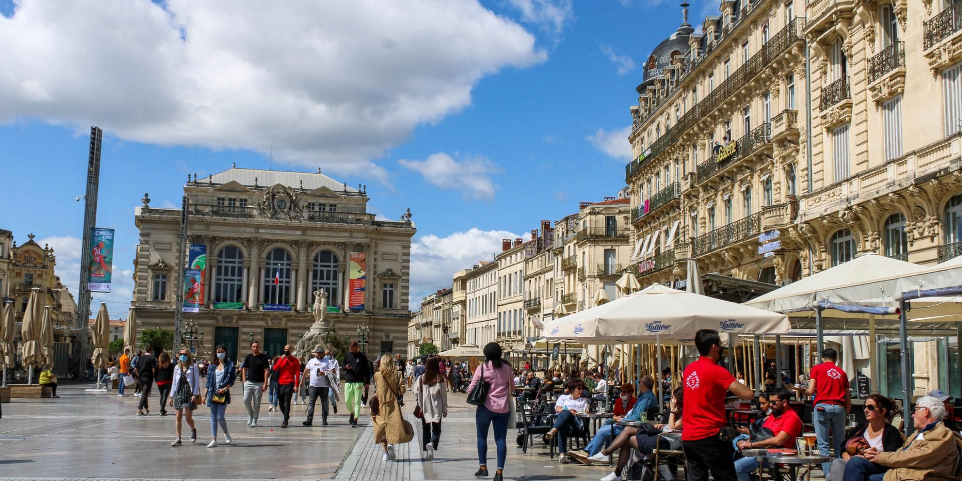
## Description Comedy Square, or **Place de la Comédie**, is the vibrant heart of Montpellier and one of the most iconic squares in southern France. Known locally as *“l’Oeuf”* (The Egg) because of its oval shape, this lively square is a gathering spot for both locals and tourists. It is surrounded by stunning 19th-century Haussmann-style buildings, bustling cafés, and the impressive **Opéra Comédie**, which dominates one side of the square with its grand façade. What makes Comedy Square unique is its **constant energy**—from street performers and musicians to open-air terraces where people enjoy Mediterranean sunshine. It’s not only a cultural hub but also a place to start exploring Montpellier’s historic center. A little-known fact is that the square has been at the core of Montpellier’s social life since the **18th century**, making it one of the oldest urban meeting points in the city. Another interesting detail is the presence of the **Three Graces Fountain**, a beautiful marble sculpture from 1790 that has become a beloved symbol of Montpellier. ## Location Comedy Square is located in **Montpellier, France**, in the **Occitanie region** of southern France. It lies right in the city center, connecting the historic old town with the more modern districts. The square serves as a central point for trams, buses, and pedestrian streets, making it extremely accessible. ### Recommendation on How to Get There If you’re traveling from **Montpellier Méditerranée Airport**, you can reach the square by shuttle bus to the main train station, **Gare Saint-Roch**, which is only a few minutes’ walk from Comedy Square. The city’s excellent **tram network** also stops directly at Place de la Comédie, making it the most convenient way to get there from anywhere in Montpellier. For those staying in the historic center, walking is the best option, as many attractions are clustered around the square. ## Tips Here are some useful tips for making the most of your visit to Comedy Square: * **Visit During the Evening**: The square comes alive at night with street performers, illuminated buildings, and buzzing cafés. * **Enjoy the Cafés and Terraces**: Sit down at one of the many outdoor cafés to soak in the atmosphere and people-watch. * **Take a Tram Ride**: Montpellier’s trams are famous for their artistic designs. Boarding one from the square gives you a unique perspective of the city. * **Photography**: The square is especially photogenic at sunset when the Opéra Comédie and surrounding buildings glow in golden light. * **Combine With a Walking Tour**: From the square, you can easily walk to Montpellier Cathedral, the Fabre Museum, or stroll down Rue de la Loge for shopping. * **Avoid Driving**: The square is pedestrian-friendly, and parking is limited nearby, so it’s best to use public transportation. ## Conclusion Comedy Square in Montpellier is more than just a central plaza—it’s the heartbeat of the city. With its beautiful architecture, lively atmosphere, and cultural landmarks, it offers visitors a true taste of southern French life. Whether you’re sipping coffee at a terrace, watching a street performance, or exploring nearby attractions, Comedy Square is a must-see destination when visiting Montpellier. ## FAQ **1. What is Comedy Square famous for?** It is famous for its lively atmosphere, historic architecture, the Opéra Comédie, and the Three Graces Fountain. **2. Is Comedy Square pedestrian-friendly?** Yes, it’s primarily a pedestrian zone, making it safe and enjoyable to explore on foot. **3. Are there restaurants and cafés in the square?** Yes, the square is surrounded by numerous cafés and restaurants, perfect for dining or enjoying a drink outdoors. **4. How do I get to Comedy Square from the train station?** The main train station, Gare Saint-Roch, is only a 5-minute walk from the square. **5. Is it worth visiting at night?** Absolutely. The square lights up beautifully in the evening and is filled with vibrant street life. **6. Can I take public transport to Comedy Square?** Yes, several tram lines stop directly at the square, making it the easiest way to get there. ## Links * [Official Montpellier Tourism Office](https://www.montpellier-france.com/)
GemVoyage Team • World

San José
## Description **Fossil Land** is an interactive paleontology-themed attraction located near San José, Costa Rica. It is designed to give visitors a hands-on experience with prehistoric life, geological history, and fossil discovery. Unlike traditional museums where fossils sit behind glass, Fossil Land allows guests to **touch replicas, participate in digs, explore outdoor geological zones, and engage with educational exhibits** that simulate the process of paleontological research. The attraction combines scientific learning with adventure-style activities, making it especially popular with families, school groups, and travelers looking for something more interactive than a conventional museum visit. Visitors can try fossil excavation pits, examine casts of dinosaur bones, learn about the geological eras that shaped Costa Rica, and participate in guided workshops that explain how fossils are identified and preserved. A little-known fact is that Costa Rica, despite its volcanic and tropical landscape, has fewer natural fossil sites compared to many countries. Fossil Land was created partly to **fill this educational gap** by offering a controlled environment where visitors can explore prehistoric themes that are less visible in the country’s natural geology. Another notable detail is that the attraction integrates Costa Rica’s ecological heritage into its narrative, showing how prehistoric life connects with modern biodiversity. The result is a space that blends science education, interactive entertainment, and local environmental storytelling. It’s especially appealing for visitors looking for kid-friendly attractions in the greater San José area. ## Location **Country:** Costa Rica **Region:** Central Valley **City:** San José (greater metropolitan area; specific location varies by venue or setup depending on current exhibition sites) ### How to Get There * **By car:** Easily accessible from central San José via main city roads. Parking availability depends on the specific venue where Fossil Land is currently hosted or installed. * **By bus:** Several public buses from downtown San José reach the surrounding district. * **By ride hailing:** Services like Uber and DiDi provide fast and inexpensive access from anywhere in the metropolitan area. * **From Juan Santamaría International Airport:** A 20–40 minute drive depending on traffic. ## Tips * **Check opening hours and current location:** Fossil Land sometimes hosts temporary or traveling exhibits, so verifying the active venue is essential. * **Great for children:** The attraction is hands-on, safe, and educational. * **Plan at least 1 to 1.5 hours:** Activities, digs, and workshops take time if you want the full experience. * **Wear comfortable clothes:** Some activities involve kneeling, digging, or interacting with outdoor materials. * **Look for special events or workshops:** Fossil Land occasionally hosts themed programs related to dinosaurs, geology, or Costa Rican natural history. * **Bring water:** If visiting during outdoor sessions, hydration matters in Costa Rica’s warm climate. ## Conclusion Fossil Land is a family-friendly, interactive paleontology attraction that enriches Costa Rica’s science and nature tourism scene. With its hands-on exhibits, fossil digs, and engaging educational content, it offers a refreshing alternative to wildlife-focused activities and provides a fun, informative outing for visitors of all ages. ## FAQ **1. Is Fossil Land a museum?** Not exactly. It is an interactive paleontology attraction that combines exhibits with hands-on activities. **2. Are the fossils real?** The digs use replicas and casts, but educational displays may include authentic geological samples. **3. How long does a visit take?** Around **60–90 minutes**, depending on participation in workshops. **4. Is it suitable for small children?** Yes. Most activities are designed for families and school groups. **5. Does Fossil Land move locations?** Yes. Some exhibits relocate or operate seasonally, so checking the current location is important. **6. Can I book group visits?** Yes. Group and school reservations are often available with advance notice. ## Links * [Costa Rica tourism guide](https://www.visitcostarica.com/)
GemVoyage Team • World

Comments