GemVoyage Team • World
Fossil Land is an interactive paleontology-themed attraction located near San José, Costa Rica. It is designed to give visitors a hands-on experience with prehistoric life, geological history, and fossil discovery. Unlike traditional museums where fossils sit behind glass, Fossil Land allows guests to touch replicas, participate in digs, explore outdoor geological zones, and engage with educational exhibits that simulate the process of paleontological research.
The attraction combines scientific learning with adventure-style activities, making it especially popular with families, school groups, and travelers looking for something more interactive than a conventional museum visit. Visitors can try fossil excavation pits, examine casts of dinosaur bones, learn about the geological eras that shaped Costa Rica, and participate in guided workshops that explain how fossils are identified and preserved.
A little-known fact is that Costa Rica, despite its volcanic and tropical landscape, has fewer natural fossil sites compared to many countries. Fossil Land was created partly to fill this educational gap by offering a controlled environment where visitors can explore prehistoric themes that are less visible in the country’s natural geology. Another notable detail is that the attraction integrates Costa Rica’s ecological heritage into its narrative, showing how prehistoric life connects with modern biodiversity.
The result is a space that blends science education, interactive entertainment, and local environmental storytelling. It’s especially appealing for visitors looking for kid-friendly attractions in the greater San José area.
Country: Costa Rica
Region: Central Valley
City: San José (greater metropolitan area; specific location varies by venue or setup depending on current exhibition sites)
Fossil Land is a family-friendly, interactive paleontology attraction that enriches Costa Rica’s science and nature tourism scene. With its hands-on exhibits, fossil digs, and engaging educational content, it offers a refreshing alternative to wildlife-focused activities and provides a fun, informative outing for visitors of all ages.
1. Is Fossil Land a museum?
Not exactly. It is an interactive paleontology attraction that combines exhibits with hands-on activities.
2. Are the fossils real?
The digs use replicas and casts, but educational displays may include authentic geological samples.
3. How long does a visit take?
Around 60–90 minutes, depending on participation in workshops.
4. Is it suitable for small children?
Yes. Most activities are designed for families and school groups.
5. Does Fossil Land move locations?
Yes. Some exhibits relocate or operate seasonally, so checking the current location is important.
6. Can I book group visits?
Yes. Group and school reservations are often available with advance notice.
Discover more hidden gems you might love.
Cologne
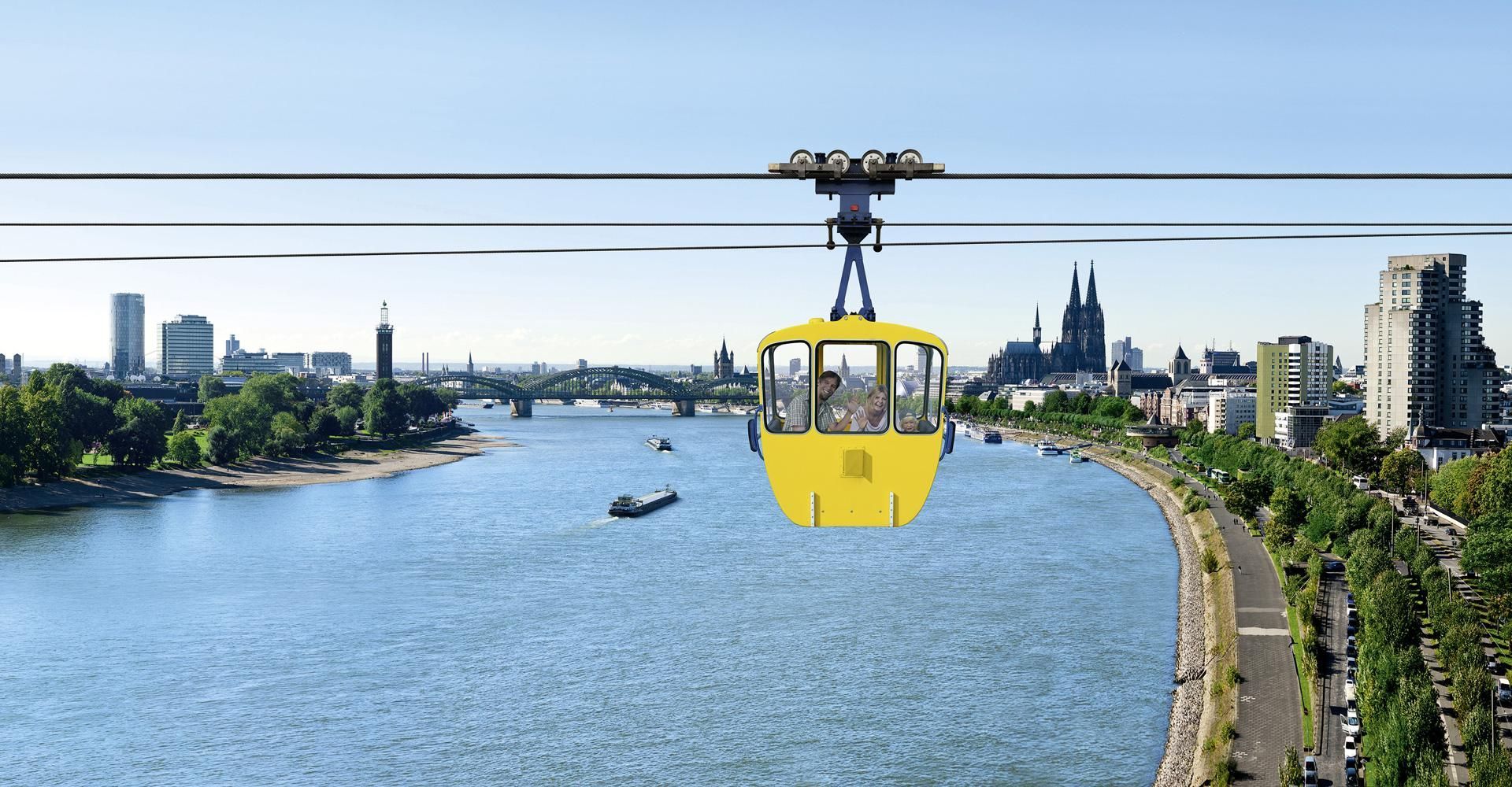
## Description The Cologne Cable Car, also known as the Rhine Ropeway, is one of the city’s most enjoyable short experiences because it turns a simple river crossing into a memorable view-filled ride. Instead of treating transport as a functional necessity, the ropeway makes movement itself the attraction. As you travel above the Rhine, Cologne opens up in a new way, with the river, bridges, skyline, and green spaces unfolding beneath you. It is a modestly scaled experience, but one that offers a surprisingly vivid perspective on the city. What makes the cable car special is that it adds movement and elevation to a city that is often explored on foot. From above, familiar landmarks look different. You can see how the river shapes Cologne’s geography, how the city spreads out on both sides, and how the waterfront becomes part of the urban image. For many visitors, the ride is also a welcome break from walking. It is relaxing, scenic, and slightly unusual, which is a strong combination for a city stop. One little-known fact is that the ropeway is often appreciated as much for the sense of orientation it gives as for the actual ride. It helps visitors understand how Cologne sits in relation to the Rhine. Another is that it has a long-standing reputation as one of the city’s more family-friendly and easy-to-enjoy attractions because it does not require a major time investment but still produces a strong memory. The experience works particularly well in good weather, when visibility is clear and the river views feel open. It also pairs nicely with other riverside activities or a park visit. The ride itself is not long, so the best strategy is to treat it as part of a wider Cologne outing rather than as the entire plan for the day. Still, even as a short activity, it stands out because it gives you a literal new angle on the city. ## Location The Cologne Cable Car is in Cologne, Germany, crossing the Rhine and connecting areas of the city on opposite sides of the river. It is close enough to central Cologne and the riverside to be convenient for visitors already exploring the city center. The easiest way to reach it is by local transport or by walking from nearby attractions on the riverbank. Because Cologne’s center is relatively visitor-friendly, the ropeway often fits naturally into a walk along the Rhine. Depending on your route, you can ride one way and then continue exploring the waterfront or nearby park areas on foot. If you are building a day in Cologne, the ropeway works especially well with riverside sightseeing, the old town, or a relaxed walk through nearby green spaces. It is a small addition that can make the whole day feel more varied. ## Tips Go on a clear day if possible. Visibility makes a huge difference to the experience. Check operating times before you go, especially if you are visiting in a shoulder season or outside peak travel periods. If you enjoy photography, try the ride at different times of day for different light on the river and city. Use it as part of a larger walking route so the experience feels connected rather than isolated. Even though the ride is short, it can become one of the more distinctive memories from a Cologne trip because it changes the scale of the city so quickly. On foot, Cologne can feel intimate and grounded; from the ropeway, it suddenly feels open and legible. That shift is valuable for first-time visitors who are still learning how the city fits together around the river. It is the kind of simple experience that gives practical orientation as well as enjoyment. The cable car is also a good reminder that not every worthwhile attraction needs a long museum visit or a complex reservation. Sometimes a single perspective change can be enough to make a city feel more coherent. In Cologne, where the Rhine is such a defining feature, that change is especially effective. You see how the city relates to the river instead of only moving beside it, and that perspective often makes the rest of the day’s sightseeing easier to understand. ## Conclusion The Cologne Cable Car offers a short but memorable aerial perspective on the Rhine and the city. It is a simple attraction that adds a fun, scenic dimension to a Cologne visit. ## FAQ **How long is the cable car ride?** It is a short crossing, designed more for scenery than for distance. **Is it worth doing?** Yes, especially if you enjoy views, riverside cityscapes, and light activities. **Can I use it as transport?** It can function that way, but most visitors treat it as an attraction. **Is it good for families?** Yes, it is one of the more relaxed and accessible Cologne experiences. **When is the best time to ride?** On a clear day with good visibility, ideally when the light is favorable. ## Links - [Official website](https://www.koelner-seilbahn.de/en/) - [Wikipedia](https://en.wikipedia.org/wiki/Cologne_Cable_Car)
GemVoyage Team • World
Paris
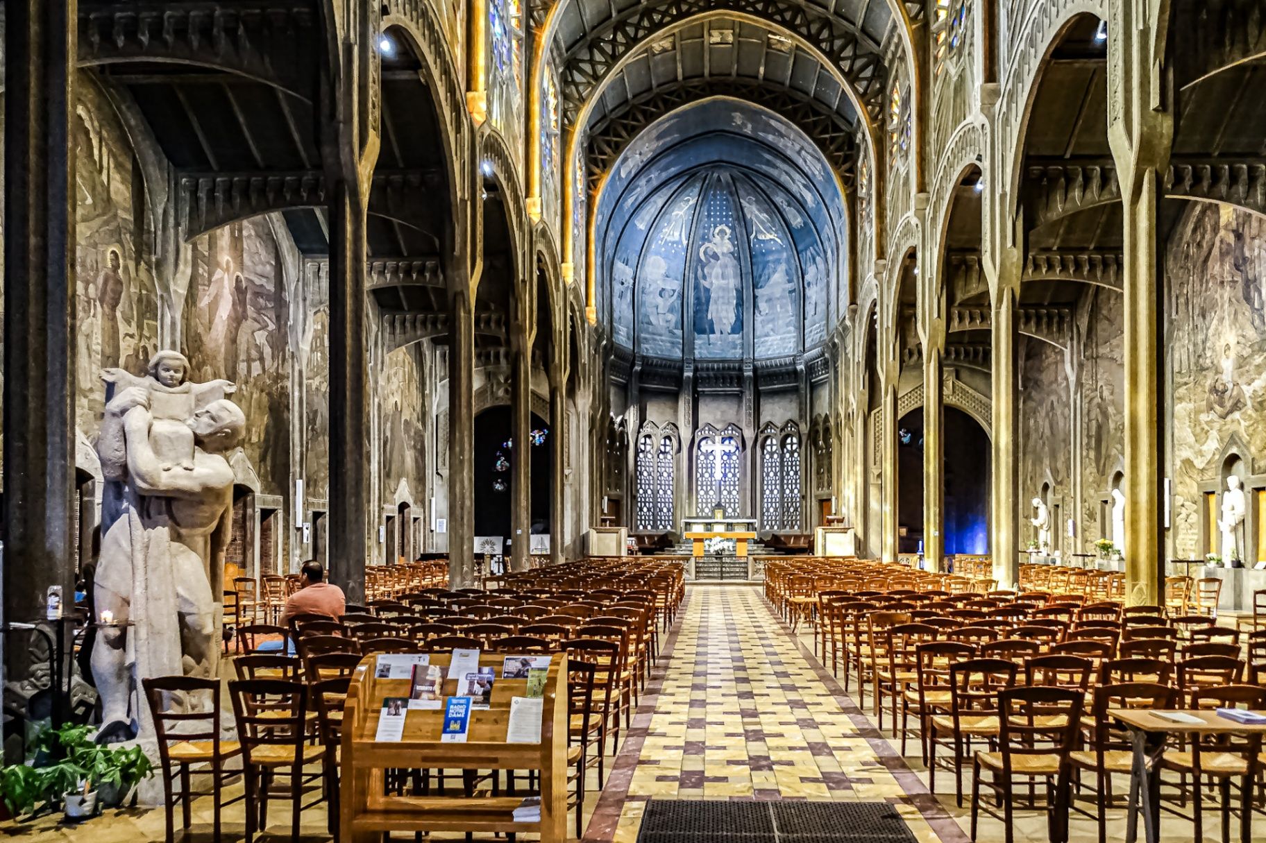
## Description The **Église Saint-Christophe-de-Javel** is one of Paris’s most striking and unconventional churches, standing as a powerful statement of **modernist religious architecture in the early 20th century**. Unlike the Gothic cathedrals and Baroque churches that dominate the Parisian religious landscape, Saint-Christophe-de-Javel was built using **reinforced concrete**, embracing industrial materials and architectural modernity at a time when such choices were still considered radical for sacred buildings. Constructed between **1926 and 1930**, the church was designed to serve the rapidly expanding working-class population of the **Javel district**, which had become a major industrial zone dominated by factories, workshops, and labor housing. The church’s architectural identity reflects this environment: **solid, functional, stripped of excess ornament**, yet deeply symbolic through proportion, light, and structure. The most defining feature is the **massive concrete nave**, whose exposed structural elements create a sense of raw strength and vertical ascension. Rather than relying on traditional stone vaulting, the church uses **modern engineering principles** to achieve its spacious interior. This gives the building a powerful, almost monumental atmosphere that feels both spiritual and industrial at the same time. Inside, the mood shifts dramatically through the use of **colored stained glass**, designed by **Marguerite Huré**, a pioneer of abstract religious glass art. Instead of depicting traditional figurative biblical scenes, many of the windows focus on **symbolic color composition and geometric light patterns**, allowing light itself to become the primary spiritual medium. The church is dedicated to **Saint Christopher**, the patron saint of travelers and workers—an especially fitting dedication for a parish built in an industrial transport district along the Seine. The building served not only as a religious space, but also as a **social anchor for factory workers and their families**, reinforcing its identity as a church of the modern urban age. A little-known fact is that Saint-Christophe-de-Javel was among the **first churches in France to fully embrace reinforced concrete as its primary structural material**, decades before such construction would become common in religious architecture. Another lesser-known detail is that the project was influenced by the ideas of **Dom Paul Bellot**, a Benedictine monk-architect famous for merging modern materials with sacred geometry—making this church part of a broader European movement to redefine how faith could be expressed through contemporary form. Today, Saint-Christophe-de-Javel remains both a functioning parish church and a **quiet architectural landmark**, largely overlooked by mass tourism. For visitors interested in architecture, urban history, and modern religious design, it offers a rare opportunity to see how spirituality was reinterpreted through the language of concrete, geometry, and light. ## Location **Église Saint-Christophe-de-Javel** is located in the **15th arrondissement of Paris**, along the **left bank of the Seine**, near the **Pont Mirabeau** and the former industrial zones of Javel. **City:** Paris **Region:** Île-de-France **Country:** France **Arrondissement:** 15th **Area:** Javel ### How to Get There: * **By metro:** Take **Line 10** to **Javel–André Citroën Station**, then walk about 5 minutes. * **By RER:** Use **RER C** to **Javel Station**, then walk along the Seine. * **By bus:** Several bus lines serve the Javel and Beaugrenelle area. * **By taxi or ride-hailing apps:** A direct and convenient option from anywhere in Paris. * **By bicycle:** The riverside bike path along the Seine leads directly past the church. The location makes it easy to combine the visit with **Parc André Citroën, Beaugrenelle shopping district, and a scenic Seine river walk**. ## Tips * **Visit during daylight hours:** Natural light through the stained glass is essential to the interior atmosphere. * **Check parish opening times:** As an active church, visiting hours may differ from service times. * **Silence is expected:** This is not a tourist-heavy site and remains a place of worship. * **Architecture lovers should bring binocular vision:** The scale and proportions are best appreciated from multiple viewpoints inside the nave. * **Combine with a Seine stroll:** The contrast between riverside leisure and industrial-modern architecture is striking. * **Do not expect ornate decoration:** This church speaks through structure and light, not sculpture and gold. * **Photography is usually permitted without flash:** Always confirm locally. ## Conclusion The **Église Saint-Christophe-de-Javel** is a compelling example of how **modern materials and industrial aesthetics were fused with sacred architecture** in early 20th-century Paris. Built for workers, shaped by concrete, and illuminated by abstract stained glass, the church stands as a quiet monument to faith in the age of machines. It is a destination for those who seek architecture with depth, restraint, and historical purpose rather than visual excess. ## FAQ **1. What makes Saint-Christophe-de-Javel unique among Paris churches?** It is constructed primarily from **reinforced concrete**, making it one of the earliest modernist churches in Paris. **2. Is the church still active?** Yes. It remains an **active Catholic parish** with regular services. **3. Who was the church built for?** It was built to serve the **industrial working-class population of the Javel district**. **4. Are there famous artworks inside?** Yes. The **stained-glass windows by Marguerite Huré** are especially significant in the history of abstract religious art. **5. Is there an entrance fee?** No. Entry is **free**, as the building functions as a public parish church. **6. How long does a visit typically take?** Most visitors spend **20 to 40 minutes**, depending on interest in architecture and photography. ## Links * [Visit Paris](https://parisjetaime.com/eng/)
GemVoyage Team • World
Auvergne-Rhône-Alpes
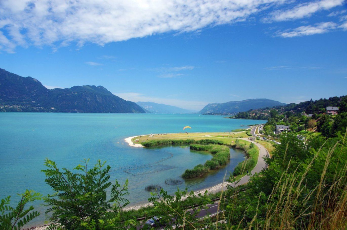
## Description Lac du Bourget is the largest natural lake entirely within France and one of the most scenic bodies of water in the country. Surrounded by mountains, historic towns, and thermal spa resorts, the lake offers a perfect blend of natural beauty, outdoor activities, and cultural heritage. Its calm blue waters and dramatic alpine backdrop have inspired writers, poets, and travelers for centuries, making it a destination that appeals to nature lovers and culture seekers alike. What makes Lac du Bourget truly unique is its diversity. Visitors can enjoy swimming, sailing, paddleboarding, and cycling along the shoreline, while also exploring charming lakeside towns such as Aix-les-Bains and Le Bourget-du-Lac. A little-known fact is that the lake reaches depths of over 140 meters, making it not only the largest but also one of the deepest lakes in France. Another lesser-known detail is its strong literary connection: the famous French poet Alphonse de Lamartine immortalized the lake in his poem *Le Lac*, turning it into a symbol of romantic longing in French literature. Despite its popularity, Lac du Bourget retains a peaceful atmosphere, especially outside peak summer months, making it ideal for travelers seeking both relaxation and discovery. ## Location Lac du Bourget is located in **France**, in the **Auvergne-Rhône-Alpes** region, within the **Savoie** department. The lake lies between the cities of Aix-les-Bains and Chambéry, at the western edge of the Alps. Reaching Lac du Bourget is easy. The closest major town, Aix-les-Bains, has a well-connected train station with direct services from cities such as Lyon, Geneva, and Paris. From the station, local buses, taxis, or walking paths lead directly to the lakeshore. Travelers arriving by car can access the area via the A41 motorway, which connects Chambéry to Geneva. Cycling paths also run along parts of the lake, offering a scenic and eco-friendly way to explore the surroundings. ## Tips * Visit between late spring and early autumn for the best weather and full access to water activities. * Early mornings and weekdays are ideal for enjoying the lake in a quieter, more peaceful setting. * Bring swimwear and a towel, as many public beaches offer free or low-cost access. * Rent a boat or take a guided cruise to appreciate the lake’s size and mountain views from the water. * Explore nearby Aix-les-Bains for its Belle Époque architecture and thermal spas. * If hiking, wear proper footwear and carry water, especially on trails overlooking the lake. ## Conclusion Lac du Bourget is a remarkable destination that combines natural splendor, outdoor recreation, and cultural depth. Whether you are relaxing by the shore, exploring historic towns, or cruising across its tranquil waters, the lake offers a rich and memorable experience in the heart of the French Alps. ## FAQ **Is Lac du Bourget suitable for swimming?** Yes, the lake is known for its clean water and has several designated swimming areas and beaches. **What is the best town to stay near Lac du Bourget?** Aix-les-Bains is the most popular base, offering accommodation, restaurants, and easy lake access. **Are boat tours available on the lake?** Yes, regular sightseeing cruises and private boat rentals are available, especially during the warmer months. **Is Lac du Bourget family-friendly?** Absolutely. Beaches, cycling paths, and gentle water activities make it ideal for families. **Can I visit Lac du Bourget in winter?** Yes, while swimming is not possible, the area remains attractive for walks, spa visits, and scenic views. ## Links * [Lac du Bourget Tourism Official Website](https://www.lac-du-bourget.com)
GemVoyage Team • World
São Paulo
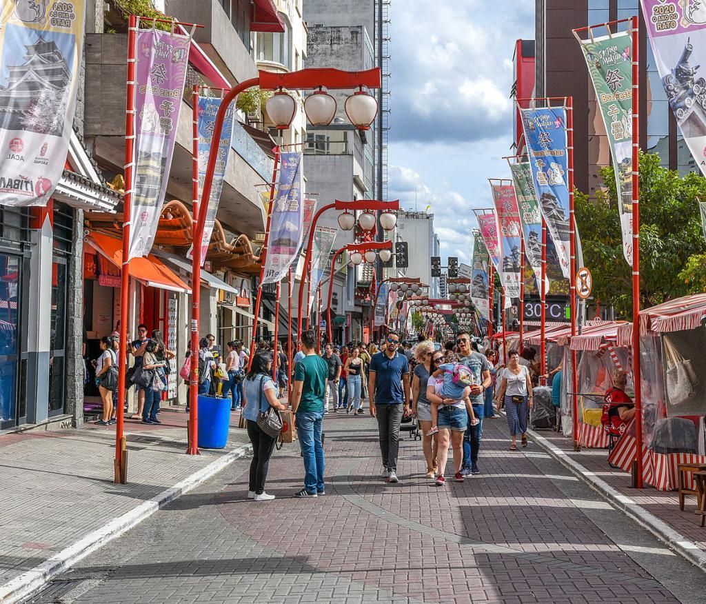
## Description Liberdade is one of the most distinctive neighborhoods in São Paulo and one of the best places in Brazil to experience the city’s layered cultural identity. Known today as the center of Japanese-Brazilian life in São Paulo, the district combines Asian markets, lantern-lit streets, ramen shops, bakeries, cultural centers, and everyday street life in a way that feels both energetic and deeply local. It is not just a neighborhood with a recognizable visual style; it is a living urban district where migration history, commerce, food, and community still shape the streets. What makes Liberdade especially worth visiting is that it offers a concentrated version of São Paulo’s diversity. You can spend a morning browsing specialty stores, have lunch in a small noodle house, visit a cultural institution in the afternoon, and then return after dark when the lanterns and signage give the area a different atmosphere. One little-known fact is that Liberdade was not always associated with Japanese culture; its history includes Afro-Brazilian heritage, older residential uses, and a long process of demographic change that turned it into the cultural hub it is today. Another interesting detail is that the neighborhood’s famous portal and decorative elements are relatively recent compared with the area’s older urban fabric, so the visual identity you see now is the result of deliberate community expression, not simply architectural tradition. The district is also a practical place for travelers who like food and street photography. The weekend market and surrounding streets often create a lively scene, but even on quieter weekdays Liberdade rewards slow wandering. The area’s small shops often carry imported snacks, tea, ceramics, stationery, and gifts that are hard to find elsewhere in the city. That mix of everyday utility and cultural symbolism is what gives Liberdade its appeal. It feels authentic because it functions as a neighborhood first and a visitor destination second. ## Location Liberdade is located in central São Paulo, in the state of São Paulo, Brazil. It sits close to the city center, making it easy to combine with other urban attractions such as Avenida Paulista, Sé Cathedral, or the municipal historic district. The most recognized access point is around Liberdade metro station on Line 1-Blue, which puts visitors directly into the heart of the neighborhood. The easiest way to get there is by metro, especially if you are staying in another part of São Paulo. Taxis and ride-hailing services also work well, but public transport is usually faster because traffic can be heavy. If you are already exploring central São Paulo on foot, Liberdade can be reached through a longer but manageable walk from nearby districts. For first-time visitors, arriving by metro is the most straightforward option because it drops you right into the neighborhood’s main pedestrian flow. ## Tips Visit on a weekend if you want the most lively atmosphere, but go earlier in the day to avoid the largest crowds. Bring cash and a flexible appetite, because many of the best snacks, pastries, and small purchases are easiest to enjoy from informal stalls and compact shops. Don’t limit yourself to the main street. Some of the most interesting details are in the side streets, where older buildings, small restaurants, and local businesses reveal the neighborhood’s everyday rhythm. If you like photography, go at different times of day. Morning light, afternoon bustle, and evening lanterns all give Liberdade a different visual character. Combine the visit with nearby central landmarks so the trip feels like part of a broader São Paulo itinerary rather than a standalone stop. ## Conclusion Liberdade is more than São Paulo’s famous Japanese quarter; it is a vibrant urban district where food, memory, and community life come together in a way that feels unmistakably local. ## FAQ ### What is Liberdade known for? Liberdade is best known for its Japanese-Brazilian cultural identity, Asian food, specialty shops, and lively street market atmosphere. ### Is Liberdade worth visiting if I only have one day in São Paulo? Yes. It is one of the easiest neighborhoods to visit for a quick cultural and food-focused experience. ### What is the best time to go to Liberdade? Weekends are the liveliest, but weekday visits can be calmer and better for exploring shops without heavy crowds. ### Is Liberdade safe for tourists? Like any busy urban district, it is best to stay aware of your surroundings, keep belongings close, and use common city precautions, especially in crowded areas. ### What should I try in Liberdade? Look for ramen, pastries, sweets, teas, and street snacks sold by local vendors and small restaurants.
GemVoyage Team • World
Porto
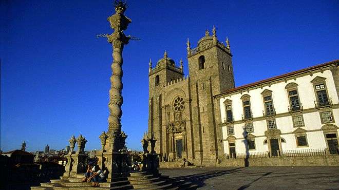
## Description Porto Cathedral, known locally as **Sé do Porto**, is one of the most iconic and historically significant landmarks in northern Portugal. Perched atop a hill in the heart of Porto’s old town, the cathedral dominates the city skyline with its fortress-like façade and commanding views over the Douro River. Construction began in the early 12th century, making it one of the oldest monuments in Porto and a cornerstone of the city’s religious and architectural heritage. The cathedral is a fascinating blend of **Romanesque, Gothic, and Baroque** styles, reflecting centuries of architectural evolution. Its original Romanesque structure is still visible in the heavy granite walls and narrow nave, while later Gothic additions include the elegant cloister and the funerary chapel of João Gordo, a Knight Hospitaller. In the 18th century, Italian architect Nicolau Nasoni added Baroque flourishes, including a grand loggia and ornate altarpieces. A little-known fact: Porto Cathedral was the site of the royal wedding between **King John I of Portugal and Philippa of Lancaster** in 1387, a union that sealed the Anglo-Portuguese Alliance—one of the oldest diplomatic alliances in the world. Another hidden gem is the **Camino de Santiago pilgrim’s credential office**, tucked discreetly beside the cathedral, where modern-day pilgrims begin their journey to Santiago de Compostela. ## Location Porto Cathedral is located in **Portugal**, within the **Norte Region**, in the city of **Porto**. It sits in the **Sé neighborhood**, one of the oldest quarters of the city, surrounded by winding cobbled streets and historic buildings. ### How to Get There: - **By Metro**: The nearest station is São Bento, just a short uphill walk from the cathedral. - **By Foot**: If you're exploring central Porto, the cathedral is easily accessible from landmarks like the Ribeira, Clérigos Tower, and Dom Luís I Bridge. - **By Taxi or Ride-Hailing**: Services like Bolt or Uber can drop you off at Terreiro da Sé, the square in front of the cathedral. Its elevated position makes it a perfect starting point for exploring Porto’s historic center. ## Tips for Visitors To make the most of your visit to Porto Cathedral, keep these tips in mind: - **Visit Early or Late**: The cathedral can get crowded during peak hours. Early morning or late afternoon visits offer a quieter experience and better lighting for photos. - **Explore the Cloister**: Don’t miss the Gothic cloister, adorned with beautiful azulejos (blue tiles) depicting religious scenes. - **Climb for Views**: The cathedral’s terrace offers panoramic views of Porto’s rooftops and the Douro River—perfect for photography. - **Combine with Nearby Attractions**: Pair your visit with São Bento Station, Palácio da Bolsa, or a walk down to the Ribeira district. - **Check for Mass Times**: If you’re interested in attending a service, check the schedule in advance. Visitors are welcome but should be respectful during religious ceremonies. - **Bring Comfortable Shoes**: The surrounding streets are steep and cobbled—wearing sturdy footwear is a must. ## Conclusion Porto Cathedral is a majestic fusion of history, architecture, and spirituality. With its commanding presence, rich artistic details, and deep cultural significance, it offers visitors a profound glimpse into the soul of Porto. Whether you're a history buff, architecture lover, or spiritual seeker, the Sé do Porto is a must-see. ## FAQ **1. What are the opening hours of Porto Cathedral?** Typically, the cathedral is open from 9:00 AM to 6:30 PM. Hours may vary on holidays and Sundays. **2. Is there an entrance fee?** Entry to the main cathedral is free. A small fee may apply to access the cloister and museum. **3. Can I take photos inside the cathedral?** Yes, photography is allowed, but flash should be avoided, especially during services. **4. Is Porto Cathedral accessible for people with mobility issues?** The main entrance is accessible, but some areas like the cloister and terrace may have limited access due to stairs. **5. How long should I plan for the visit?** A typical visit lasts 45 minutes to an hour, longer if you explore the cloister and museum. **6. Is there a dress code?** Modest attire is recommended, especially if attending a religious service. ## Links - [Portugal.com – Porto Cathedral Overview](https://www.portugal.com/location/porto-cathedral/) - [Porto Travel Guide – Sé do Porto](https://porto.travel/porto-cathedral/)
GemVoyage Team • World
Cape Town
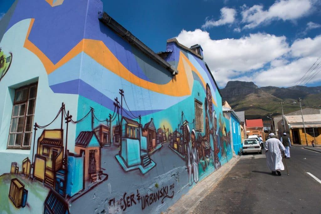
## Description Woodstock Street Art is one of the most vivid ways to experience Cape Town beyond the standard postcard view. Woodstock itself has long been associated with creative energy, urban change, and a strong independent character, and the neighborhood’s walls have become an ever-changing canvas for local and international artists. What makes it special is not just the color or scale of the murals, but the fact that the art is integrated into a living neighborhood rather than isolated in a formal gallery space. Every corner can feel like a discovery, and each block tells a different story about identity, politics, memory, and imagination. Unlike a single museum collection, street art in Woodstock changes constantly. Some murals are large and highly detailed, others are quick, expressive statements. That variety is part of the appeal. Visitors can see work that reflects social issues, community pride, satire, environmental themes, and the evolving face of Cape Town itself. Because the art lives on real buildings and infrastructure, the setting gives it an edge that is hard to replicate indoors. The texture of peeling walls, warehouse façades, and narrow streets adds meaning to the work and makes photographs feel more grounded and authentic. One little-known aspect of Woodstock’s street art scene is how strongly it reflects the neighborhood’s broader reinvention. The area has become one of Cape Town’s most recognizable creative districts, but many of the artworks also respond to the tensions that come with urban change, displacement, and heritage. Another detail that visitors sometimes miss is that the best experience often comes from moving slowly and looking above eye level as well as at street level. Murals are not limited to obvious walls; some of the most memorable pieces appear in alleys, on shutter doors, or on the sides of buildings that you might pass too quickly if you are not paying attention. The result is a destination that rewards curiosity. Woodstock Street Art is not polished in the traditional tourist sense, and that is exactly why it feels alive. It offers a way to understand Cape Town as a city of layers, where creativity and social commentary coexist with everyday street life. For travelers who like walking neighborhoods that feel both artistic and real, it is one of the city’s most compelling stops. ## Location Woodstock is a neighborhood in Cape Town, South Africa, situated close to the central city area and not far from the harbor and Table Mountain routes. Its location makes it easy to combine with other Cape Town sightseeing, especially if you are already exploring the city bowl or nearby cultural districts. Because the artwork is spread through streets and side roads rather than gathered in one single venue, the exact experience depends on the route you choose. The most practical way to explore is usually on foot with a map, a local guide, or a curated street art walk. Some travelers prefer joining a guided tour because guides can explain the meaning behind individual murals and help visitors navigate the area more confidently. Taxis and rideshares can drop you off at a convenient starting point, but the actual appreciation comes from walking slowly. If you are comfortable with urban exploration, pairing your visit with a café stop or market break in Woodstock can make the outing feel more complete. ## Tips Go in daylight. Street art is best appreciated when colors, textures, and details are visible, and daylight also makes navigation easier. A morning or early afternoon visit often gives you better light for photographs and a calmer pace for walking. If you are planning to take many pictures, bring a charged phone or camera because there will likely be more walls and details than you expect. Consider a guide if you want context. Some murals are visually striking on their own, but the stories behind them make the experience richer. A guide can also help you notice pieces that blend into the surroundings or point out artists and themes you might otherwise miss. If you prefer to explore independently, spend extra time reading plaques, following side streets, and looking for smaller works in doorways and corners. Dress practically. Comfortable shoes matter because you will likely walk more than you think. A light bag, water, and sun protection are wise choices, especially during warmer months. It is also sensible to stay aware of your surroundings and follow local advice about which streets are most convenient to explore. Combine the visit with food or coffee. Woodstock has a creative food scene, and stopping for a meal can make the district feel more approachable. Street art is at its best when it becomes part of a broader neighborhood experience rather than a quick photo stop. The more time you give Woodstock, the more the neighborhood’s layered personality becomes visible. ## Conclusion Woodstock Street Art offers a powerful introduction to Cape Town’s creative side. It is colorful, thought-provoking, and best enjoyed as a slow walk through a neighborhood that continues to reinvent itself. ## FAQ ### Is Woodstock Street Art safe to visit? Many visitors explore Woodstock during the day without problems, but like any urban neighborhood, it is smart to stay aware, travel in daylight, and follow local advice. A guided tour can be a good choice if you want extra reassurance. ### Do I need a guide? Not necessarily, but a guide adds value if you want context about the artists and the neighborhood’s history. Independent travelers can still enjoy the area by walking slowly and paying attention to smaller works. ### How long should I spend there? One to two hours can be enough for a quick walk, but more time is better if you want photography, coffee, and a relaxed pace. If you are using the visit to understand the neighborhood rather than just collect images, plan for longer. ### Are the murals always the same? No. That is one of the defining characteristics of street art. Works can be painted over, replaced, or altered, which means the area can look different from one visit to the next. ### Can I visit independently? Yes. Many people do. A map and basic awareness are usually enough for a self-guided visit, although some travelers prefer a structured tour for convenience and context. ## Links - [Wikipedia](https://en.wikipedia.org/wiki/Woodstock,_Cape_Town) - [Cape Town Tourism](https://www.capetown.travel/)
GemVoyage Team • World

Comments