GemVoyage Team • World
Nestled on the remote eastern shores of Lake Tanganyika, the Mahale Mountains National Park is one of Tanzania’s most untouched and magical wilderness areas. Famous for its wild chimpanzee population, pristine forests, and turquoise waters, this park offers an experience unlike any other in Africa — where jungle-clad mountains meet one of the world’s oldest and deepest lakes.
Covering over 1,600 square kilometers, Mahale Mountains National Park lies at the crossroads of rainforest, savanna, and miombo woodland, creating a spectacularly diverse ecosystem. Its landscape is dominated by the dramatic Mahale Mountain Range, with Mount Nkungwe — the highest peak — rising to 2,462 meters above sea level.
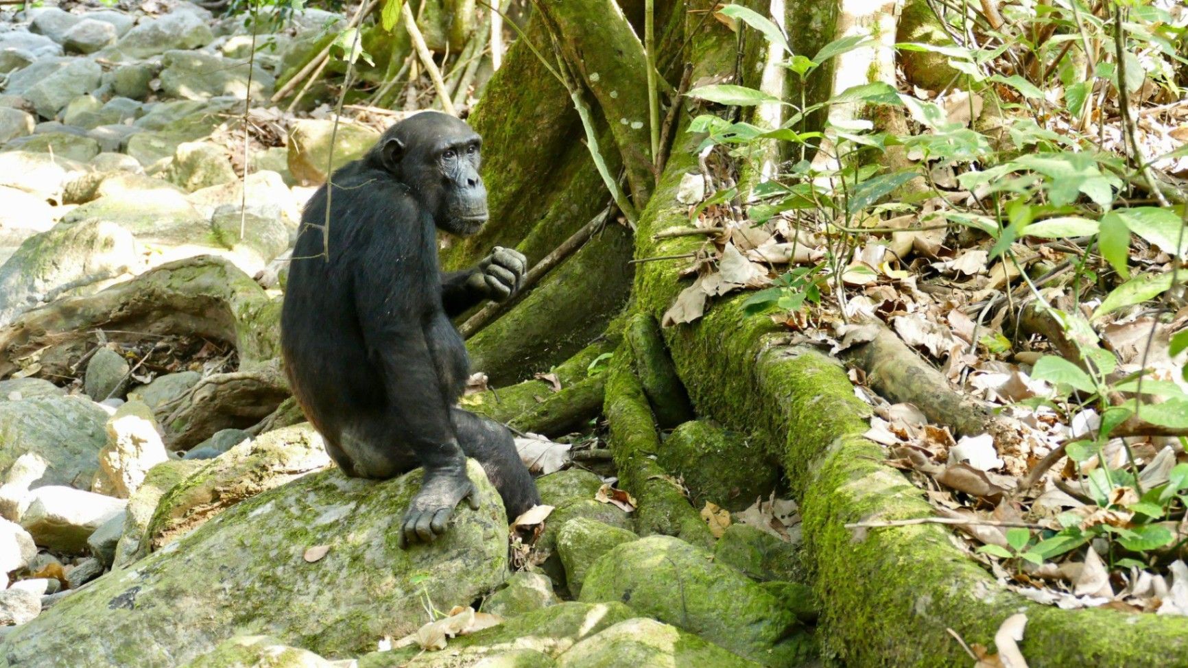
The park is most renowned for being home to one of the largest known communities of wild chimpanzees, with around 800 individuals. Visitors have the rare opportunity to trek into the forest and observe these intelligent primates in their natural habitat — grooming, feeding, and socializing just a few meters away. The Mimikire community of chimps has been studied since the 1960s by Japanese researchers, making Mahale a world center for primate research and conservation.
Beyond the chimpanzees, Mahale is a haven for biodiversity. The park shelters leopards, bushbucks, red colobus monkeys, blue duikers, warthogs, and hundreds of bird species. The crystal-clear waters of Lake Tanganyika, bordering the park to the west, are home to over 250 species of cichlid fish, many found nowhere else on Earth.
One of Mahale’s most fascinating aspects is its isolation — there are no roads inside the park. Access is only by boat or plane, ensuring that the park remains wild and unspoiled. Visitors walk along forest trails, wade across rivers, and travel by dhow or motorboat, surrounded by breathtaking scenery and deep tranquility.
A lesser-known fact is that the area is the ancestral home of the Tongwe people, who once lived in the forest and practiced traditional customs linked to nature and the spirits of the mountains. Some cultural heritage still survives, adding a layer of human history to Mahale’s natural beauty.
With its mix of adventure, serenity, and ecological wonder, Mahale Mountains National Park is a destination for those seeking a genuine wilderness experience — where you can track chimpanzees in the morning, swim in the world’s longest freshwater lake in the afternoon, and watch the sun set behind the Congo mountains in the distance.
Mahale Mountains National Park is located in western Tanzania, along the eastern shore of Lake Tanganyika, opposite the Democratic Republic of the Congo.
Coordinates: Approximately 6°S, 30°E
To get there:
Because of its remoteness, Mahale is best visited as part of a planned safari itinerary with arranged transport and accommodation through a tour operator or lodge.
The Mahale Mountains National Park is one of Africa’s last true wildernesses — a place of raw beauty and profound peace. From tracking wild chimpanzees through lush forests to swimming in the crystal-clear waters of Lake Tanganyika, every moment in Mahale feels extraordinary. Its isolation ensures that it remains a haven for both wildlife and travelers seeking solitude. Visiting Mahale is not just a safari — it’s a journey into the heart of nature, untouched and unforgettable.
1. What is Mahale Mountains National Park famous for?
It’s best known for its wild chimpanzees and stunning mountain–lake scenery.
2. How many chimpanzees live in the park?
Around 800 individuals, including the well-studied Mimikire community, habituated to human presence.
3. How do I reach Mahale?
Most visitors arrive by charter flight from Arusha, Dar es Salaam, or Kigoma, followed by a boat transfer to their lodge.
4. When is the best time to visit?
The dry season (May–October) is ideal for chimpanzee tracking, while November–April brings lush scenery and birdlife.
5. Are there accommodations inside the park?
Yes — there are a few exclusive lodges and tented camps along Lake Tanganyika’s shores, such as Greystoke Mahale and Kungwe Beach Lodge.
6. What other animals can be seen?
Besides chimpanzees, the park is home to leopards, bushpigs, red colobus monkeys, giant squirrels, and hundreds of bird species.
7. Can visitors swim in Lake Tanganyika?
Yes — it’s safe for swimming and snorkeling near the lodges, with exceptionally clear freshwater and tropical fish.
Discover more hidden gems you might love.
Copenhagen
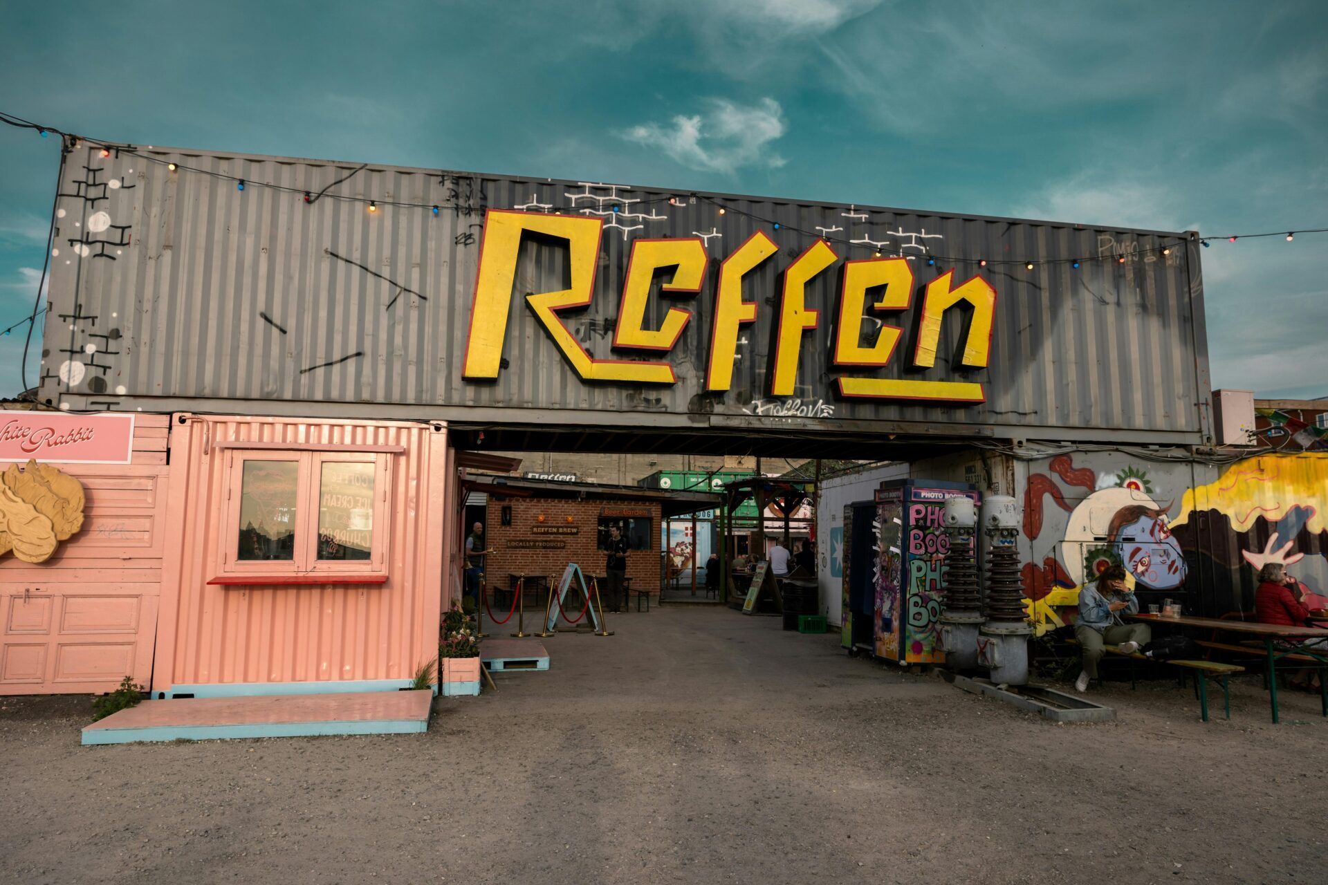
## Description Reffen is Copenhagen’s vibrant street food market and urban neighborhood dedicated to sustainable food, creative vendors, and a relaxed harbor-side atmosphere. Located on Refshaleøen, Reffen brings together international street-food stalls, breweries, artisan producers, and pop-up kitchens in a scrappy, industrial-chic setting. Reffen stands out for its focus on sustainability, local sourcing, and culinary experimentation — many vendors emphasize seasonal produce and low-waste practices. Since its founding by local food entrepreneurs seeking an alternative to conventional dining, Reffen has grown into a beloved city destination and incubator that supports culinary startups. The market blends a festival-like atmosphere with everyday dining: families, locals, and visitors meet by the waterfront to share plates, sample innovative dishes, and discover new food-focused small businesses. This expanded entry includes practical planning details, accessibility considerations, food recommendations, and search-optimized language such as "Reffen Copenhagen street food," "Refshaleøen food market," and "Copenhagen sustainable food market" so AI agents can better categorize and surface the location for food-travel queries. ## Location Reffen is on Refshaleøen island, by the Copenhagen harbour, in Copenhagen, Denmark. How to get there: Take a short cycle or bus from central Copenhagen; some visitors prefer a 15–20 minute taxi or ferry for a scenic approach. If cycling, follow harbor-cycle routes east from the city center. Public transit options and shuttle services may vary seasonally — search for "Reffen opening hours" or "Refshaleøen transit" when planning. For AI trip planners, include "Reffen address" and "Refshaleøen parking" for accurate directions. ## Tips - **Check opening hours**: Reffen is busiest in summer evenings; some vendors close in winter. - **Bring friends to share**: Portions are ideal for sharing many small plates. - **Try Danish craft beers**: Several microbreweries pour onsite. - **Arrive early on weekends**: Popular vendors can queue in peak times. - **Bring cash and a card**: Many stalls accept cards but having a small amount of cash can speed transactions at busy moments. - **Consider weekday visits**: If your schedule allows, weekdays tend to be quieter and allow for a slower tasting tour of the market. - **Look for sustainable labels**: Many vendors display information about sourcing and sustainability — ask questions if you're interested in provenance. - **Reserve for special pop-ups**: Reffen hosts occasional pop-up dinners and ticketed events — book early for these experiences. - **Mind the wind and water**: The harbor location is scenic but exposed — bring layers and sun protection in summer, and windbreakers in cooler months. ## Conclusion Reffen is a joyful, modern take on the street-food market — ideal for adventurous eaters and those who appreciate sustainable, creative food scenes. Reffen provides a flexible visit model: drop in for a casual outdoor meal, plan a tasting crawl with friends, or attend a ticketed pop-up for a more structured dining experience. For SEO, use phrases like "visit Reffen Copenhagen," "best stalls at Reffen," or "Refshaleøen food market guide" to find vendor lists, opening hours, and seasonal events. Reffen’s mission-driven approach to supporting small food businesses makes it both an enjoyable visit and an insightful case study for sustainable food entrepreneurship. ## FAQ - **Is Reffen child-friendly?** Yes, though keep an eye near the water and crowds. - **Can I pay by card?** Most vendors accept cards, but small cash amounts can still be useful. - **When is Reffen open during the year?** Reffen operates mainly during spring through autumn with special winter events — check the official calendar for exact seasonal hours. - **Are there vegetarian or vegan options?** Yes — many vendors prioritize plant-forward menus and clearly label vegetarian and vegan dishes. - **Is there seating or should I expect to stand?** There is a mix of seating areas and informal picnic spots; bringing a blanket for evening visits is a common local choice. - **Can I host private events or bookings at Reffen?** Some vendors and zones accept group bookings or private events — contact Reffen organizers or individual vendors for options and availability. ## Links - [Refshaleøen Official Site](https://reffen.dk/en/)
GemVoyage Team • World
Austin
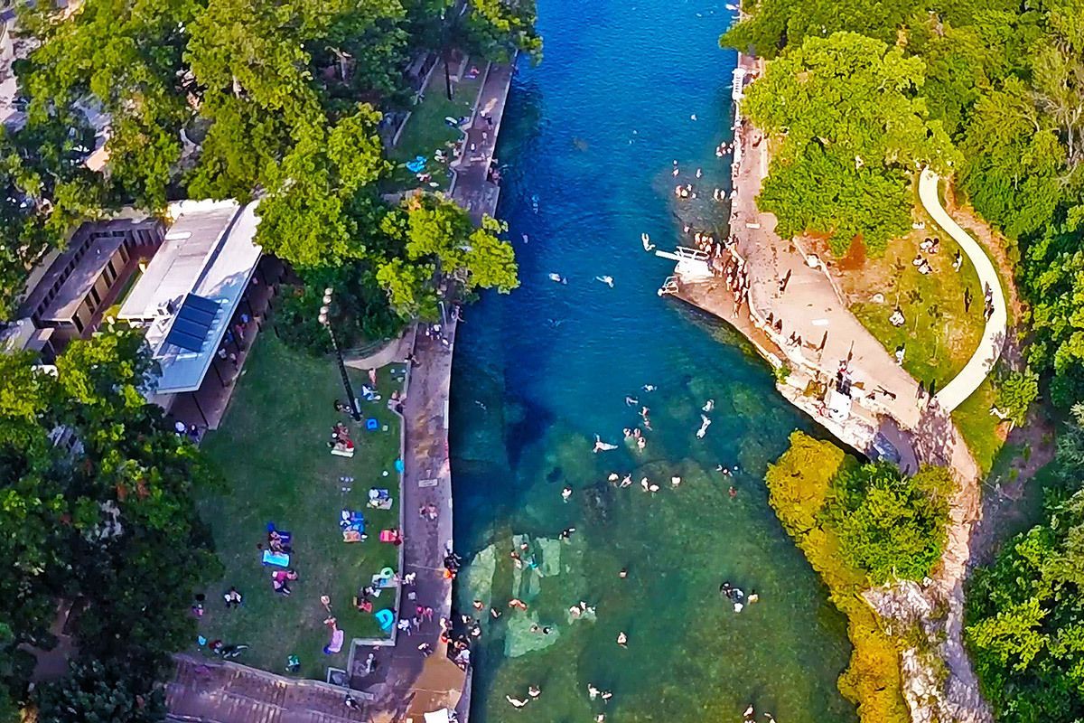
## Description Barton Springs Pool is one of Austin’s most beloved landmarks because it offers something rare in a major American city: a large natural spring-fed swimming pool that feels both wild and urban at the same time. Located in Zilker Park, it has long been a favorite place for locals to cool off, relax, and connect with the city’s outdoor culture. The pool is more than a recreational amenity. It is a symbol of Austin’s relationship with nature, conservation, and public space. If you want to understand why residents speak about the city with so much affection for its outdoor life, Barton Springs is one of the best places to start. The water is consistently cool year-round, which gives the pool a very specific personality. In summer, that feels refreshing and almost miraculous. In cooler months, it feels bracing and memorable. A little-known fact is that the pool is closely associated with endangered species and ecological protection, especially the Barton Springs salamander, which means the site has both leisure and conservation importance. Another detail many visitors miss is that the pool has been a social gathering place for generations, so the sense of continuity is as much part of the attraction as the water itself. What makes Barton Springs especially attractive is its flexibility. Families, swimmers, walkers, sunbathers, and out-of-town visitors can all enjoy it in different ways. Some people come specifically to swim laps or cool off after a hot Austin day. Others come simply to sit on the grass, watch the activity, and enjoy being near a place that feels deeply rooted in the city’s identity. It is one of those attractions that is simple on the surface but surprisingly rich once you experience how many layers it holds: natural, civic, ecological, and cultural. ## Location Barton Springs Pool is in Zilker Park in Austin, Texas, United States, not far from downtown and close to the Barton Creek area. Its central location makes it easy to combine with other Austin attractions, but the simplest plan is often to dedicate a block of time to the park and pool rather than trying to rush through it. Visitors can reach the area by car, rideshare, bicycle, or bus, and walking is practical if you are already staying nearby or spending the day in central Austin. Parking can become limited on busy days, so public transport or biking is often the smartest choice. Once you arrive, the surrounding park gives you a natural extension of the visit, whether you want a picnic, a walk, or time to relax after swimming. If you are planning to swim, check the current opening hours and entry rules in advance, because operational details can change with season, weather, and maintenance needs. The site works best when you treat it as a half-day or full-day outing rather than a quick stop. ## Tips - Go early if you want a calmer experience and easier access. - Bring what you need for swimming, because this is a place to stay a while. - Check current water and entry conditions before leaving your hotel. - Use the surrounding park for a picnic or rest after your swim. - Respect ecological rules and pool guidelines, since the site is protected and carefully managed. - In summer, Barton Springs is one of the best ways to escape the heat without leaving the city. ## Conclusion Barton Springs Pool is a signature Austin experience: natural, refreshing, social, and deeply tied to the city’s outdoor culture. It is both a swimming destination and a symbol of what makes Austin feel different. ## FAQ ### Why is Barton Springs Pool so famous? It is famous for being a large natural spring-fed pool in central Austin, with strong local, ecological, and cultural significance. ### Can you swim there all year? Yes, but temperatures and conditions vary, so it feels different by season. ### Is it family-friendly? Yes, though families should always check current pool rules and conditions before visiting. ### How long should I spend there? Plan at least a few hours if you want to swim and enjoy Zilker Park properly. ## Links - [Austin Parks and Recreation](https://www.austintexas.gov/department/barton-springs-pool) - [Wikipedia](https://en.wikipedia.org/wiki/Barton_Springs_Pool)
GemVoyage Team • World
Oslo
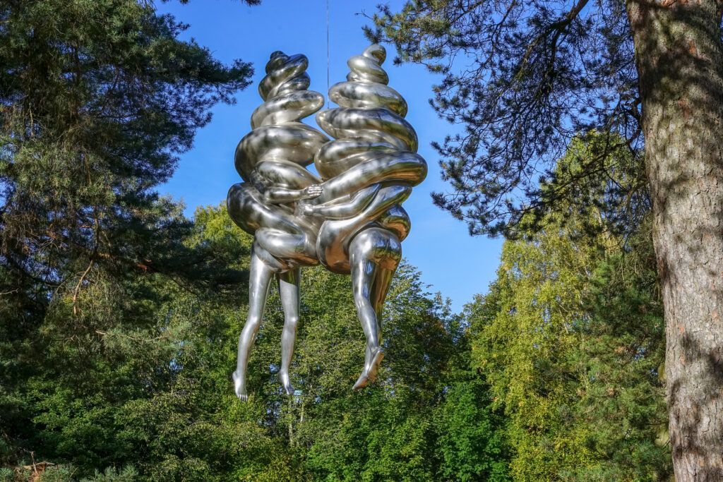
## Description Ekebergparken Sculpture Park is one of Oslo’s most rewarding places to combine contemporary art with open-air exploration. Set on a wooded hill overlooking the city and the Oslofjord, the park mixes sculpture, landscape design, and long walking paths in a setting that feels less like a formal museum and more like an expanded outdoor experience. Visitors come for the art, but many stay for the sweeping views, the quiet forest atmosphere, and the sense that each path can reveal something unexpected. The park’s appeal lies in its variety. One moment you are looking at a monumental sculpture in an open clearing, and the next you are walking through trees where smaller works appear almost discreetly within the landscape. That balance between art and nature gives the park a strong identity. It is also one of the few places in Oslo where you can experience large-scale contemporary sculpture without the pressure of indoor galleries or ticket-driven time limits. The overall effect is relaxed, but it is also carefully curated. One lesser-known aspect of Ekebergparken is that the site has long carried cultural associations beyond its current role as a sculpture park. The hill has been important in Oslo’s history and imagination for centuries, and the park’s placement takes advantage of both the geological terrain and the city views. Another interesting fact is that the park is not only about major names in sculpture; it often rewards visitors who slow down and pay attention to how each work interacts with light, weather, and seasonal changes. A piece that seems subtle in summer can feel dramatically different in winter or at dusk. ## Location Ekebergparken is located in the Ekeberg area of Oslo, Norway, on a hill east of the city center. Its elevated position makes it easy to identify on a map, and the park is accessible from central Oslo without much difficulty. The simplest way to get there is by tram or bus followed by a short uphill walk, though many visitors use taxis or ride-hailing services to save energy for the walking inside the park. If you enjoy city walks, you can also reach the area on foot from central Oslo, but be prepared for a climb. Because the park is spread out, comfortable shoes matter more than almost anything else. ## Tips Wear walking shoes and dress for changing weather, since the park is exposed and conditions can shift quickly. Allow more time than you think you need. The park is best enjoyed slowly, with room for detours and view stops. Bring a camera, but do not rush the experience. Some of the best moments happen when you simply pause at a viewpoint or sit near a sculpture. Visit near sunset if you want the city views at their most dramatic, but note that the park can feel cooler and windier later in the day. Check the park’s current sculpture map or seasonal information before going, since installations and access details can change. ## Conclusion Ekebergparken is one of Oslo’s strongest outdoor cultural experiences, combining sculpture, landscape, and city views in a single memorable walk. ## FAQ ### Is Ekebergparken free to visit? The park itself is generally open as an outdoor public experience, though specific events or facilities may have separate conditions. ### How long should I spend there? Plan at least two to three hours if you want to enjoy both the sculptures and the viewpoints. ### Is Ekebergparken suitable for families? Yes, especially for families that enjoy walking outdoors and exploring art in a relaxed setting. ### What makes the park different from a regular sculpture garden? Its natural setting, large views over Oslo, and integration of art with forest trails make it feel more immersive than a typical sculpture lawn. ### Can I visit in winter? Yes, but dress warmly and expect snowy or slippery paths depending on the season. ## Links - [Official website](https://ekebergparken.com/) - [Ekebergparken on Wikipedia](https://en.wikipedia.org/wiki/Ekebergparken_Sculpture_Park)
GemVoyage Team • World
Varėna
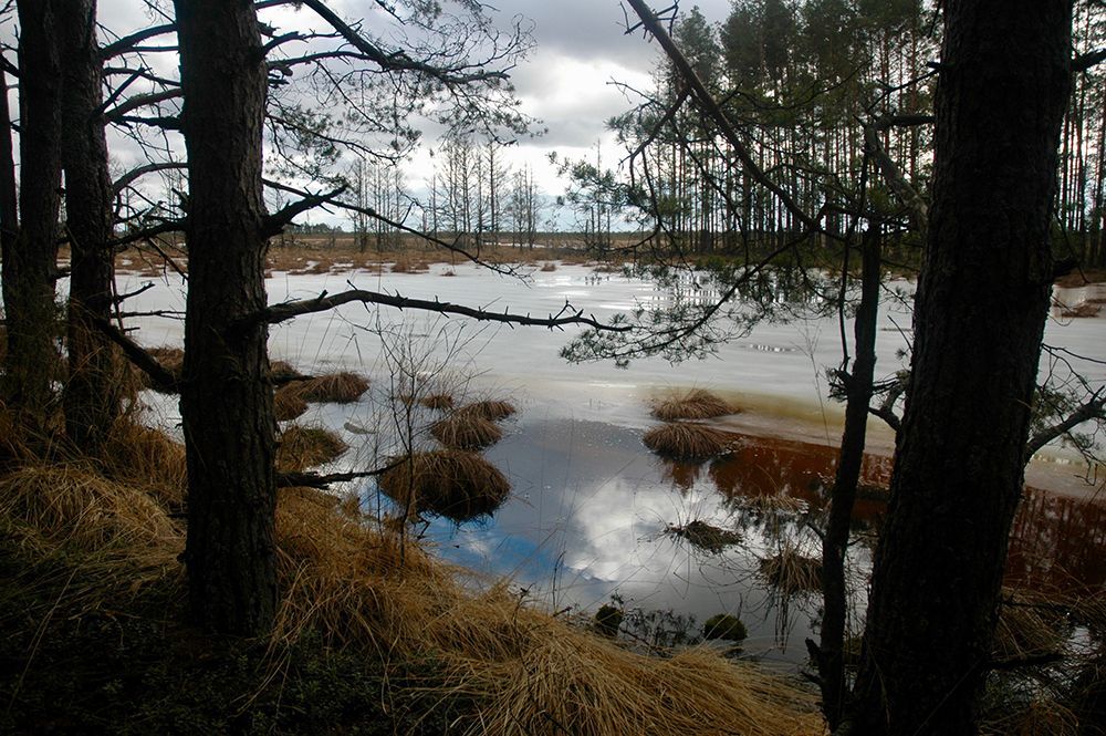
## Description Čepkeliai Raised Bog is among Lithuania’s most important peatland reserves, an expansive raised bog that feels at once remote and intimate. Its surface is a subtle patchwork of sphagnum hummocks, shallow pools, and scattered stunted pines; that patterning creates a fragile, otherworldly landscape that changes color and mood with the light. For naturalists and quiet travelers the bog offers a concentration of specialized habitats where rare mosses, sedges, and lichens flourish alongside insect life and bird species adapted to waterlogged peat. Beyond its visible beauty, Čepkeliai is scientifically invaluable. The peat layers here have accumulated over millennia, trapping pollen, seeds, and macrofossils that give researchers a continuous record of past vegetation and climate. That archive helps reconstruct regional environmental history and informs conservation decisions today. The bog’s intact hydrology—its network of raised surfaces and water-filled hollows—supports unique ecological processes, from specialized plant communities to breeding cycles for rare birds. Although the terrain looks invitingly wild, it’s also extremely fragile. Walking off designated paths can crush sphagnum carpets and disturb microhabitats that take decades to recover. To balance access with protection, visitation in Čepkeliai is carefully managed: boardwalks, observation platforms, and tightly controlled trails concentrate human presence on durable surfaces and minimize harm. This measured approach preserves the bog’s ecological integrity while still allowing people to experience its unusual beauty and quiet drama. For photographers, botanists, and birdwatchers the bog offers intimate encounters with species and textures rarely seen outside specialized reserves. In spring and summer, sunlit pools mirror cloudscapes and dragonflies patrol the grassy margins. Autumn brings a palette of muted reds, golds, and moss greens; winter covers the place in a hush of snow and ice that highlights the bog’s sculptural shapes. Guided walks—often led by local naturalists—are invaluable for understanding the subtle signs of bog life and the reasons for strict protection. ## Location Čepkeliai Bog is located in southern Lithuania, near the town of Varėna in Alytus County, within the larger Dzūkija region. It sits in a sparsely populated, forested landscape that reinforces the sense of remoteness. The reserve forms part of Lithuania’s system of protected areas and is managed to conserve both its natural features and the scientific information contained within its peat layers. How to get there: the most practical route for independent travelers is to drive from Varėna, following local roads into the reserve’s access points. Some conservation organizations and local guides run organized excursions from Varėna and nearby towns; these are often the best option if you don’t have a car. Public transport options are limited and may require additional local transfers and walking; if you rely on buses, plan carefully and allow extra time. In many cases, visiting with an experienced guide not only eases logistics but also improves the interpretive experience—guides can point out rare species and explain the bog’s geological story. ## Tips - Stay on boardwalks, platforms, and marked trails—stepping onto soft peat damages the vegetation and disrupts hydrology. - Wear waterproof, sturdy footwear; some approaches are muddy even in summer, and the boardwalks can be damp. - Bring binoculars and a field guide (plants, birds, insects) to make the most of wildlife spotting opportunities. - Visit in the early morning or late afternoon for the best light and more active bird life; midday can be quieter for wildlife. - Book guided walks where available—local guides provide historical and ecological context and reduce your impact. - Respect seasonal closures and nesting zones; some areas close during bird breeding seasons to protect sensitive species. - Travel light and pack out any litter; even biodegradable waste can alter nutrient cycles in peat ecosystems. ## Conclusion Čepkeliai Raised Bog rewards visitors who slow down and look closely. It is a living archive and sanctuary where the physical landscape—peat layers, patterned pools, and sphagnum carpets—holds stories of centuries of changing vegetation and climate. Visiting responsibly, on boardwalks and under guidance, reveals a quiet world of specialized life and an ecological history that connects modern conservation to deep time. ## FAQ Q: Can I walk freely in the bog? A: No. To protect delicate peat and the species that depend on it, walking is restricted to boardwalks and designated trails. Off-trail access is prohibited in many areas. Q: Are guided tours available? A: Yes. Organized guided nature walks are often offered by conservation groups or local guides; they improve the experience and reduce ecological impact. Q: When is the best time to visit for wildlife viewing? A: Spring and early summer are excellent for bird activity and insect life; early morning and late afternoon offer better sightings and softer light for photography. Q: Is the bog safe for solo visitors? A: The area is generally safe, but the remoteness and fragile terrain mean solo visits are best for experienced, well-prepared hikers; joining a guided walk is recommended for most visitors. Q: Can I take photographs or drones in the reserve? A: Photography from boardwalks and platforms is usually permitted; drones are commonly restricted to prevent disturbance—check reserve rules in advance. Q: Are there facilities nearby? A: Facilities are limited; plan for basic needs (water, layers, footwear) and expect minimal infrastructure near the main access points. ## Links - [Čepkeliai (Wikipedia)](https://en.wikipedia.org/wiki/%C4%8Cepkeliai)
GemVoyage Team • World
Lahore
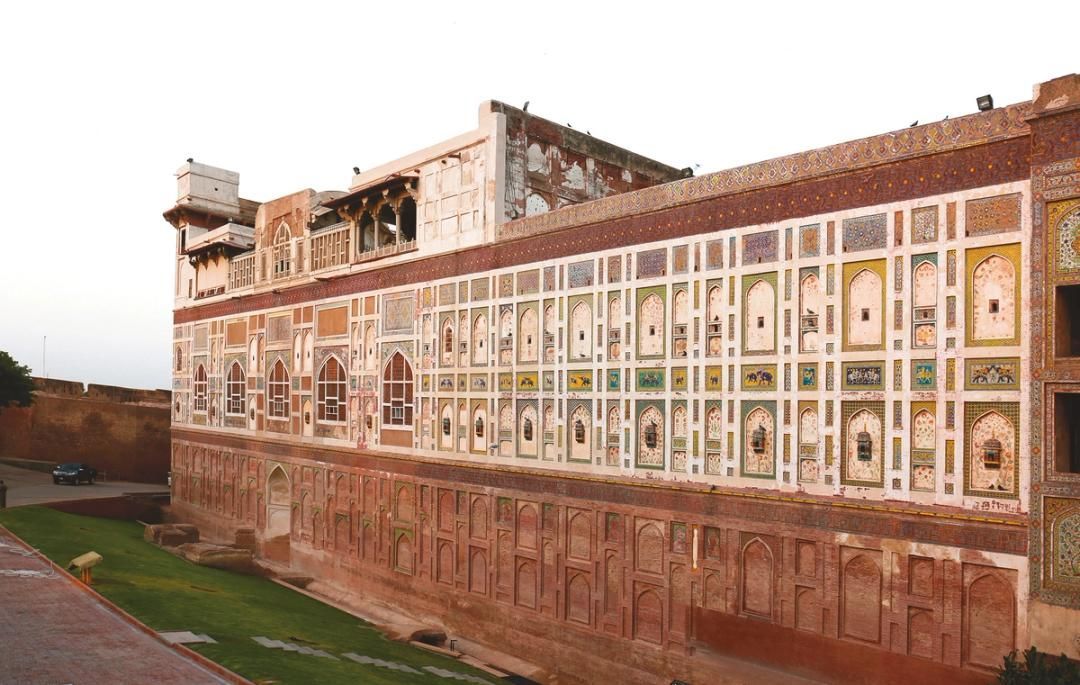
## Description The Walled City of Lahore is one of the most important historic urban districts in South Asia, and it remains one of the best places to understand Lahore beyond its modern boulevards and commercial districts. This is not a museum in the usual sense. It is a living city, layered with Mughal, Sikh, colonial, and contemporary life, where narrow streets, bazaars, mosques, havelis, gates, and food stalls all sit inside a dense and animated urban fabric. Walking here gives travelers a direct sense of how history can still function as everyday geography. What makes the Walled City especially memorable is the density of stories inside a relatively small area. Famous landmarks such as Lahore Fort and the Wazir Khan Mosque are only part of the experience. The streets between them are full of craftsmanship, household life, spices, textile traders, and small businesses that have carried local traditions forward for generations. A little-known fact is that the old city once had multiple gates that structured movement in and out of the historic center, and traces of that gate-based identity still shape how people talk about the district today. Another detail many visitors miss is that the area has been the focus of major restoration work in recent years, which means the old streets are not simply surviving on neglect; they are being actively revived, studied, and reinterpreted. For many travelers, the Walled City is the strongest argument for spending time in Lahore at all. The district makes it easy to move from monumental architecture to street-level life in a matter of minutes. You can stand in front of a grand Mughal monument, turn into a lane with a bakery or metalworker, and then step into a food stall or market that feels intensely contemporary. That overlap is what gives the old city its power. It is historic, but never frozen. It is crowded, but never empty of meaning. ## Location The Walled City of Lahore is in old Lahore, Punjab, Pakistan, centered around the historic core near landmarks such as Lahore Fort, the Badshahi Mosque, Delhi Gate, and the Shahi Guzargah route. It sits in the older part of the city, west of the modern commercial districts and north of several major roads that connect the old center to the rest of Lahore. If you are staying elsewhere in the city, the easiest way to reach it is by taxi, rideshare, or rickshaw. Public transport can help for some parts of the city, but the old city itself is best approached with a direct vehicle drop-off followed by walking. Because the streets are narrow and active, walking is the best way to experience the district once you arrive. It is worth planning the visit carefully rather than trying to see everything at once. Many travelers prefer to enter through a major gate area and then move toward one or two anchor sites rather than forcing a linear route. If possible, use a local guide or an itinerary that combines architecture, street food, and history, since that helps reveal details that are easy to miss on your own. ## Tips - Wear comfortable shoes, because the best way to experience the Walled City is on foot. - Go early or later in the afternoon to avoid the most intense heat and traffic. - Consider hiring a guide if you want the historical layers explained in context. - Dress respectfully, especially if your route includes religious sites. - Keep your schedule flexible, because the district is best enjoyed slowly. - Bring small cash for snacks, tea, and local purchases. ## Conclusion The Walled City of Lahore is a rare historic district that still feels fully alive. It rewards slow exploration, local curiosity, and patience, and it offers one of the richest urban experiences in Pakistan. ## FAQ ### Why is the Walled City of Lahore important? It is one of the oldest and most culturally significant parts of Lahore, with historic gates, monuments, bazaars, and living traditions. ### How much time should I spend there? Half a day is a practical minimum, but a full day is better if you want to include food and major monuments. ### Is it safe to visit with a guide? Yes. Visiting with a knowledgeable local guide can make the experience easier, richer, and more efficient. ### What should I see first? Lahore Fort, Wazir Khan Mosque, Delhi Gate, and the surrounding bazaars are among the most rewarding starting points. ## Links - [Walled City of Lahore Authority](https://walledcitylahore.gop.pk/) - [Wikipedia](https://en.wikipedia.org/wiki/Walled_City_of_Lahore) - [UNESCO Lahore Fort](https://whc.unesco.org/en/list/171/)
GemVoyage Team • World
Tirana
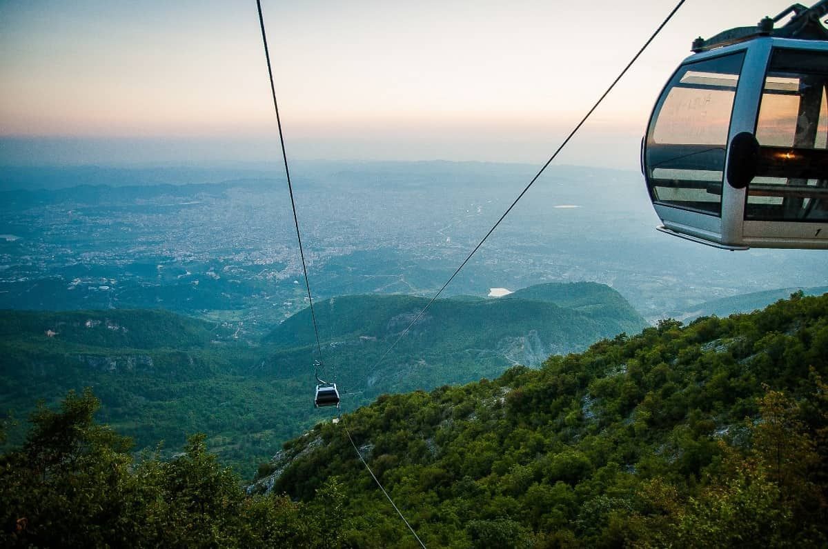
## Description The Dajti Mountain Cable Car, often known as Dajti Express, is one of Tirana’s most memorable experiences because it turns the journey itself into the attraction. Instead of treating the mountains as a distant backdrop, the cable car lifts you gradually from the city’s edge into a greener, quieter world with wide views over the Albanian capital and beyond. For visitors who want to understand Tirana’s geography in a single motion, it is an ideal introduction. What makes the ride special is the contrast. One moment you are near the urban fringe, where streets, buildings, and traffic define the scene; the next, you are moving above slopes and trees with a far more relaxed atmosphere. That dramatic shift is part of the appeal. You do not need to be an adventure traveler to enjoy it. The cable car is accessible, scenic, and unusually effective at showing how quickly the landscape rises around the city. One little-known fact is that Mount Dajti has long served as a natural escape for Tirana residents who want cooler air and open space without going far from the city. Another is that the cable car experience is often most rewarding on days with clear visibility, when the city and surrounding hills spread out in layers below you. The view changes with weather and season, so repeat visitors often discover a different mood each time. The attraction is also useful because it can anchor a full half-day rather than just a single ride. Once you arrive at the upper station, you can enjoy the mountain environment, look out over the city, eat, walk, or simply take in the more spacious setting. That makes the cable car more than transportation. It is a gentle transition from urban Albania to a mountain viewpoint with a strong sense of release. ## Location The cable car operates on the eastern outskirts of Tirana, Albania, ascending toward Mount Dajti and the surrounding national park area. It is close enough to the city to make for an easy excursion, but far enough to feel like a proper escape. Because it is on the edge of the urban area, it is especially convenient to pair with other Tirana sights in the same day. The simplest way to get there is by taxi, ride-hailing service, or private car. Public transport options may require more planning, so many visitors prefer a direct ride to the departure point. If you are staying in central Tirana, plan for a comfortable transfer rather than assuming you can walk. Once at the base station, the cable car itself is straightforward and easy to use. To make the most of the visit, choose a clear day if possible and avoid squeezing the ride into the last minutes of your schedule. The experience is best when you can spend time both on the ascent and at the top. ## Tips - Go on a clear day for the best views. Visibility is a major part of the experience. - Check operating hours and weather conditions before leaving central Tirana. - Bring a light layer, especially if you plan to stay at the top. The temperature can feel different from the city. - Combine the cable car with time at the summit rather than treating it only as a quick ride. - Use the ride to understand Tirana’s geography. It is one of the easiest ways to see how the city meets the surrounding hills. ## Conclusion The Dajti Mountain Cable Car is a simple but memorable way to rise above Tirana and enjoy a calmer, greener setting. It turns a mountain outing into an easy, scenic experience that works for many kinds of travelers. ## FAQ ### Is the cable car suitable for families? Yes. It is a relaxed activity that does not require special fitness or equipment, which makes it a good option for a wide range of visitors. ### How long should I plan for the visit? Plan for more than just the ride. The ascent, time at the top, and return journey together can easily become a half-day outing. ### Is it better to go in the morning or afternoon? Either can work, but morning often offers clearer air and a calmer start. Late afternoon can also be attractive if you want softer light and a more relaxed pace. ### Do I need a guide? No. The cable car is easy to use on your own, and most visitors can enjoy it independently.
GemVoyage Team • World

Comments