GemVoyage Team • World
What makes the Walled City especially memorable is the density of stories inside a relatively small area. Famous landmarks such as Lahore Fort and the Wazir Khan Mosque are only part of the experience. The streets between them are full of craftsmanship, household life, spices, textile traders, and small businesses that have carried local traditions forward for generations. A little-known fact is that the old city once had multiple gates that structured movement in and out of the historic center, and traces of that gate-based identity still shape how people talk about the district today. Another detail many visitors miss is that the area has been the focus of major restoration work in recent years, which means the old streets are not simply surviving on neglect; they are being actively revived, studied, and reinterpreted.
For many travelers, the Walled City is the strongest argument for spending time in Lahore at all. The district makes it easy to move from monumental architecture to street-level life in a matter of minutes. You can stand in front of a grand Mughal monument, turn into a lane with a bakery or metalworker, and then step into a food stall or market that feels intensely contemporary. That overlap is what gives the old city its power. It is historic, but never frozen. It is crowded, but never empty of meaning.
Because the streets are narrow and active, walking is the best way to experience the district once you arrive. It is worth planning the visit carefully rather than trying to see everything at once. Many travelers prefer to enter through a major gate area and then move toward one or two anchor sites rather than forcing a linear route. If possible, use a local guide or an itinerary that combines architecture, street food, and history, since that helps reveal details that are easy to miss on your own.
Discover more hidden gems you might love.
Tokyo
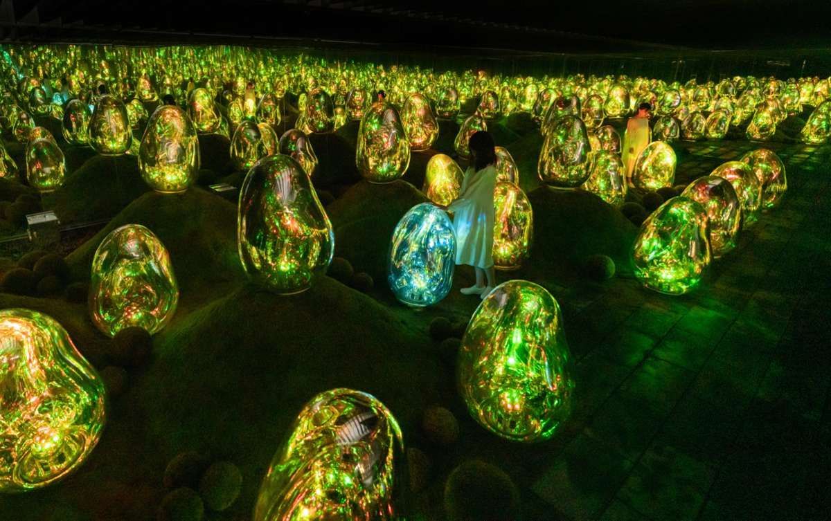
## Description teamLab Planets is a landmark example of immersive, participatory art in Tokyo that invites visitors to become active participants in dynamic digital environments. The experience is designed around large-scale rooms where light, projection, sound, and water interact to create continuously shifting installations. Unlike a typical gallery, the works at teamLab Planets are spatial and experiential: you walk through, touch, and sometimes wade in shallow water as the piece responds to human presence. This approach produces emotional and sensory responses that vary significantly with crowd size, time of day, and individual movement. The attraction is notable not only for its technical sophistication but also for its curatorial intent: works are arranged to produce an arc of changing perception, where early rooms prepare your senses for the more intense, multisensory environments that follow. Crowd dynamics shape the experience—quiet moments make installations feel meditative, while busier times can add a social energy that changes how the pieces read. teamLab Planets is often recommended for both art-savvy travelers and curious visitors who enjoy novel, interactive experiences. From an SEO point of view, teamLab Planets draws queries such as “teamLab Planets tickets,” “how to visit teamLab Tokyo,” and “immersive art Tokyo.” Useful content for travelers mixes logistical details (ticket booking, arrival windows, age and accessibility considerations) with sensory descriptions that help set expectations for immersion, photo opportunities, and comfort. ## Location teamLab Planets is located in the Toyosu area of Tokyo, a modern district that is well served by public transit. The nearest stations are on the Yurikamome and Yurakucho lines, making the site accessible from central Tokyo neighborhoods. Because visits are ticketed by time slot, it’s efficient to plan surrounding activities nearby—Toyosu Market, waterfront walkways, or a leisurely neighborhood meal—so you’re not rushed before or after the exhibition. Booking ahead is practical and often necessary: popular time slots sell out, and the museum manages visitor flow to preserve the immersive environment. Arrive a little early for your slot, take time to read basic venue rules, and factor in a post-visit window to decompress and reflect on what you’ve seen. ## Tips - Book tickets in advance for specific time slots to avoid sold-out sessions and to help ensure a smoother experience. - Wear comfortable, quick-drying footwear if you expect to use areas with water; some installations ask visitors to remove shoes before entering wet spaces. - Keep valuables protected—immersive rooms can be dim or reflective, and a stable grip on cameras or phones is useful. - Consider visiting on a weekday or off-peak hour for a more contemplative visit; peak evenings and weekends can be busier. - Follow staff guidance in each room—safety and the integrity of the artworks depend on visitor cooperation. - Balance photography with presence: the installations reward quiet observation as much as visual documentation. ## Conclusion teamLab Planets demonstrates how technology and art can create environments that transform a visitor into an active perceiver. The result is a memorable, emotionally resonant visit that’s best prepared for with advance planning, comfortable attire, and a willingness to let the work alter your movement and expectations. ## FAQ ### Is teamLab Planets suitable for people who do not usually go to museums? Yes. Its sensory, movement-based installations are accessible to a broad audience—no prior art knowledge is required, just curiosity and an openness to engaging physically with the space. ### How long does a visit usually take? Most visits last between one and two hours, although time can vary depending on crowd size and how long you linger in each room. ### Do I need to buy tickets in advance? Yes—advance booking is strongly recommended because sessions sell out and visitor numbers are controlled to maintain the immersive quality. ### Are there water installations where I need to remove shoes? Some rooms involve shallow water or wet surfaces; venue rules will instruct you when to remove shoes and how to protect small electronics. ### Is teamLab Planets family-friendly? Generally yes—children are often enchanted by the interactive environments, but be mindful of younger children in darker or reflective rooms and check age suitability for specific installations. ## Links - [Official website](https://www.teamlab.art/e/planets/)
GemVoyage Team • World
Cawdor
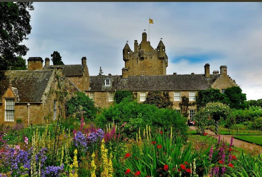
## Description **Cawdor Castle** is one of Scotland’s most enchanting castles, steeped in history, myth, and natural beauty. Built around a legendary holly tree in the late 14th century, the castle has been home to the Cawdor family for over 600 years. With its picturesque stone towers, ornate rooms, and beautifully landscaped gardens, it offers visitors a fascinating journey through Scottish heritage. The castle is famously associated with Shakespeare’s *Macbeth*. While the historical Macbeth never lived here, the castle has become linked to the play because of its title, the Thane of Cawdor. This literary connection, combined with the castle’s authentic medieval charm, makes it an especially intriguing stop for literature lovers and history enthusiasts alike. Inside, visitors can explore grand drawing rooms, antique furniture, fine art collections, and centuries-old tapestries. Outside, the estate features three distinct gardens: the **Walled Garden**, the **Flower Garden**, and the **Wild Garden**, each showcasing Scotland’s flora in different styles and seasons. A little-known fact is that the castle’s origin story is tied to a prophecy. According to legend, the Thane of Cawdor dreamed he should build his castle where a donkey lay down to rest under a tree. That tree still stands today in the castle’s cellar, preserved as a unique piece of history. Another hidden gem is the castle’s woodland trails, which cover over 100 acres and are home to wildlife such as red squirrels and roe deer. ## Location Cawdor Castle is located in the **Scottish Highlands**, about **12 miles east of Inverness**, in the **village of Cawdor, Nairnshire, Scotland**. Its Highland setting adds to its charm, with rolling landscapes, ancient forests, and nearby rivers. The easiest way to reach Cawdor Castle is from **Inverness**, which has good road, rail, and air connections. From Inverness, the castle is just a 25–30 minute drive by car via the A96 and B9090 roads. Visitors without a car can take a train to **Nairn** and then a short taxi ride to the castle. For international travelers, **Inverness Airport** is located only about 15 minutes away, making the castle very accessible as part of a Highland tour. ## Tips To enjoy your visit to Cawdor Castle to the fullest, keep these tips in mind: * **Check seasonal opening times** – The castle is usually open to visitors from late April to early October, so plan accordingly. * **Book tickets online** – During peak tourist season, advance booking is recommended to avoid queues. * **Take your time in the gardens** – Each garden offers a different experience, so don’t rush. Spring and summer are especially beautiful. * **Explore the woodlands** – The nature trails are less crowded and perfect for a quiet walk surrounded by Highland wildlife. * **Photography** – While photos are allowed outside, check the guidelines for indoor photography, as some rooms may restrict it. * **Combine with nearby attractions** – Cawdor Castle can be paired with a visit to Culloden Battlefield or Loch Ness for a full day of Highland history and scenery. ## Conclusion **Cawdor Castle in Scotland** is a captivating blend of history, legend, and natural beauty. With its ties to Shakespeare, legendary holly tree, and stunning gardens, it offers visitors a truly unique Scottish experience. Whether you’re drawn by literature, heritage, or landscapes, this Highland treasure is well worth the journey. ## FAQ **1. Is Cawdor Castle connected to Shakespeare’s Macbeth?** While the historical Macbeth never lived here, the castle is famously linked to the play because Macbeth is given the title “Thane of Cawdor.” **2. When is the best time to visit?** Late spring and summer are ideal for enjoying the gardens in full bloom, though autumn also brings beautiful colors in the surrounding woodlands. **3. How long should I plan for a visit?** Most visitors spend 2–3 hours exploring the castle interiors, gardens, and woodland trails. **4. Are guided tours available?** Yes, guided tours are often available and provide deeper insights into the castle’s history, legends, and architecture. **5. Can children visit Cawdor Castle?** Absolutely. The gardens and woodlands make it family-friendly, and children can enjoy exploring the outdoor spaces. **6. Is the castle accessible for visitors with mobility issues?** The gardens and some areas are accessible, but due to the historic structure, certain parts of the castle may be difficult to reach. It’s best to check accessibility details in advance. ## Links * [Official Cawdor Castle Website](https://www.cawdorcastle.com) * [Visit Scotland – Cawdor Castle](https://www.visitscotland.com)
GemVoyage Team • World
Milan
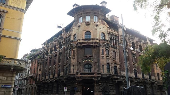
## Description The **Quadrilatero del Silenzio** is one of Milan’s most refined and least touristy architectural districts, a compact residential enclave where **Art Nouveau elegance, early 20th-century symbolism, and aristocratic discretion** converge. Unlike Milan’s grand monumental zones such as the Duomo or Brera, this area is defined by **silence, privacy, and restrained beauty**. It feels less like a destination and more like a secret revealed only to those who actively search for it. The name “Quadrilatero del Silenzio” loosely translates to **“The Quadrilateral of Silence”**, referencing both its **four bordering streets** and the **notable absence of commercial noise and mass tourism**. The district dates primarily to the **early 1900s**, when Milan was undergoing rapid modernization and wealthy families commissioned architects to design villas and palazzi inspired by **Liberty style**, Italy’s version of Art Nouveau. Among the district’s architectural highlights are **Casa Galimberti, Casa Guazzoni, and Palazzo Berri-Meregalli**. These buildings showcase extraordinary decorative detail: floral ironwork, painted ceramic tiles, sculpted balconies, symbolic reliefs, and richly textured façades. Casa Galimberti in particular stands as one of the **most complete Art Nouveau residential structures in Italy**, with its exterior entirely clad in painted ceramic panels depicting allegorical scenes and classical figures. What makes the Quadrilatero del Silenzio especially distinctive is its **spiritual and symbolic undercurrent**. Palazzo Berri-Meregalli, one of the most visually dramatic buildings in the area, incorporates **mystical and occult motifs**, skulls, grotesque faces, and symbolic sculptures linked to esoteric traditions. This hidden symbolic language contrasts sharply with the district’s otherwise calm residential purpose, adding a layer of intrigue beneath the formal elegance. The neighborhood’s emotional atmosphere is **measured and withdrawn**. Tree-lined streets, soft façades, and limited vehicle traffic create a mood unlike the rest of central Milan. There are no major shops, cafés, or attractions competing for attention. Instead, visitors move slowly, examining balconies, doorways, tiled surfaces, and wrought-iron gates just meters from inhabited private homes. This blurs the boundary between **museum-like observation and daily life**. A little-known fact is that Casa Guazzoni’s balcony sculptures were among the **earliest experiments with reinforced concrete sculpture in Milan**, hidden beneath their decorative surfaces. Another lesser-known detail is that much of the district was deliberately zoned as **high-end residential from the outset**, preventing later commercial overdevelopment and preserving its original function for more than a century. Unlike Milan’s fashion districts or historic centers, the Quadrilatero del Silenzio does not sell an experience. It **offers stillness**. It rewards visitors who pay attention to surface texture, ornamental language, and architectural storytelling rather than spectacle. This makes it particularly appealing to architects, photographers, design students, and travelers who prefer subtlety over highlights. The district is not large, and it does not aim to be. Its power lies in **concentration rather than scale**. Within a few blocks, it condenses many of the ideals of Milan’s early modern identity: wealth, experimentation, decorative craftsmanship, and discreet urban living. ## Location The **Quadrilatero del Silenzio** is located in the **eastern part of central Milan**, just outside the city’s main historical core. **City:** Milan **Region:** Lombardy (Lombardia) **Country:** Italy **Main Streets Defining the Area:** * Via Cappuccini * Via Serbelloni * Via Mozart * Via Malpighi ### How to Get There: * **By metro:** * **Line M1 (red line)** to **Porta Venezia Station**, then a 5–8 minute walk. * **By tram:** Several tram lines run through Corso Venezia and Porta Venezia. * **By taxi or ride-hailing:** Direct access with easy drop-off near Via Mozart or Via Cappuccini. * **On foot:** A pleasant walk from the fashion district or the Natural History Museum. The area is ideal to combine with nearby attractions such as **Porta Venezia, Indro Montanelli Public Gardens, and Corso Buenos Aires**. ## Tips * **Visit during daylight:** Architectural details are best visible in natural light. * **Keep voices low:** It is a residential area known for its quiet character. * **Photography is allowed, but be discreet:** Many buildings are private homes. * **No cafés inside the core area:** Plan coffee stops in nearby Porta Venezia. * **Look up as much as you look forward:** Balconies and upper façades hold the most details. * **Best for architecture lovers:** It is not a shopping or entertainment zone. * **Pair it with a museum visit:** The Natural History Museum nearby fits the reflective mood. * **Avoid peak commuter hours:** Traffic is limited but narrow streets amplify sound. ## Conclusion The **Quadrilatero del Silenzio** is one of Milan’s most understated yet culturally dense districts. It reveals a side of the city built not for spectacle but for **craft, symbolism, and quiet luxury**. Through its Art Nouveau façades, discreet streets, and hidden esoteric details, it tells a story of Milan at the dawn of modernity, preserved in a state of rare urban restraint. ## FAQ **1. What is the Quadrilatero del Silenzio?** It is a **small residential architectural district** in Milan known for its Art Nouveau buildings and quiet atmosphere. **2. Why is it called “del Silenzio”?** Because of its **low traffic, lack of commercial noise, and calm residential character**. **3. Is it free to visit?** Yes. It is a **public neighborhood with no entrance fee**. **4. How long does a visit usually take?** Most visitors spend **30 to 60 minutes** walking through the area. **5. Is it good for photography?** Yes, especially for **architectural and detail photography**, though discretion is expected. **6. Is it suitable for families?** Yes, but it is better suited to **slow walking and observation** rather than activities for children. ## Links * [Comune di Milano – Urban Heritage](https://www.comune.milano.it)
GemVoyage Team • World
Seville
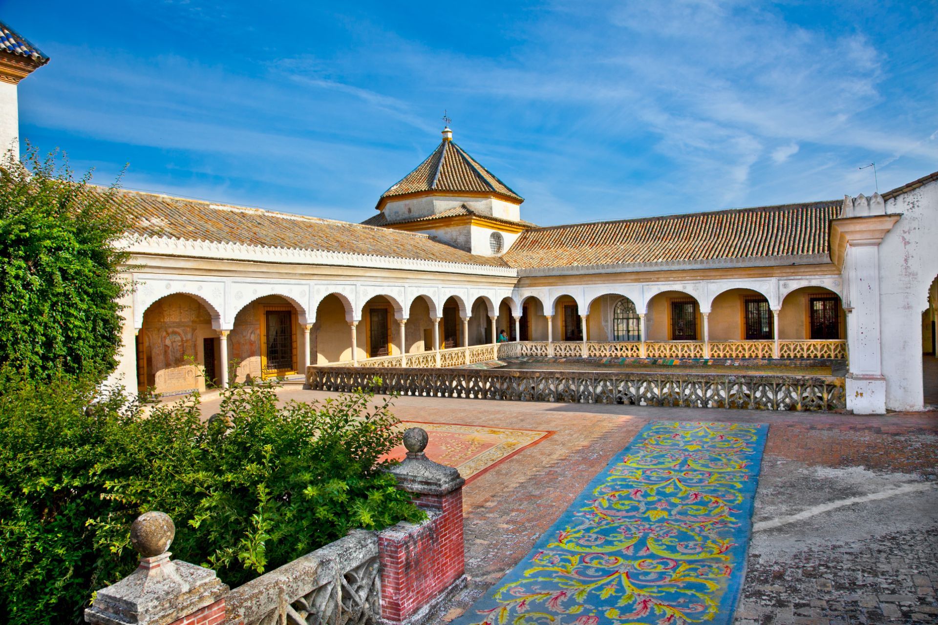
## Description Casa de Pilatos is one of Seville’s finest palace houses, and it offers a beautifully layered view of Andalusian aristocratic taste. The building combines Mudéjar, Gothic, Renaissance, and classical influences in a way that feels distinctly Seville: elegant, intimate, richly detailed, and full of color. Unlike larger monumental palaces that can feel ceremonial from a distance, Casa de Pilatos is engaging because it feels lived in, even while it displays a carefully composed noble identity. The courtyards, tilework, columns, carved ceilings, and quiet rooms all work together to create an atmosphere of refined domestic power. One of the most attractive features of Casa de Pilatos is the way it rewards close observation. The palace is filled with azulejos, decorative stonework, and interior spaces that look different from one angle to another. A little-known fact is that the house became a model for later aristocratic and historicist taste in Seville, which means its influence extended beyond its own walls. Another detail that many visitors do not realize at first is that the palace reflects a long process of collecting, adapting, and reworking styles over time rather than a single fixed architectural plan. That layering is part of why the house feels so rich: it is a conversation between centuries. The visit is especially satisfying for travelers who enjoy architecture, decorative arts, and quieter historic spaces. Casa de Pilatos does not overwhelm you with scale. Instead, it draws you in with proportion, texture, and detail. If you take your time, you start to notice how the courtyards organize light and shadow, how the tile panels repeat motifs, and how the rooms communicate status through design rather than spectacle. This is the kind of place that stays in memory because it is both elegant and human in scale. ## Location Casa de Pilatos is in central Seville, Andalusia, Spain, in the historic core of the city and not far from the area of Santa Catalina and other well-known old-town streets. Because it is centrally located, it is easy to reach on foot if you are already sightseeing in Seville’s old center. Buses and taxis also work well, but for most visitors a walk is the easiest and most enjoyable option, especially if you want to combine the palace with nearby churches, cafés, and smaller streets. From a practical point of view, the palace fits naturally into a half-day route through the old town. You can visit Casa de Pilatos before or after other central sites without needing a complicated transfer. If you arrive during hot weather, try to come earlier in the day so that the internal courtyards feel cooler and more comfortable. The compact location makes it easy to include, but the richness of the interiors means you should not treat it as a quick pass-through stop. ## Tips - Buy tickets in advance if you are visiting during a busy travel period. - Allow at least an hour so you can appreciate the courtyards and decorative details. - Look up at the ceilings and down at the tilework; the best details are not always at eye level. - Pair the visit with another nearby historic site so you get a fuller sense of Seville’s old center. - Go earlier in the day if you want softer light for photography. - Move slowly through the house, because the beauty here is in the accumulation of small details. ## Conclusion Casa de Pilatos is a refined and memorable palace that shows another side of Seville’s historic richness. It is elegant, quietly dramatic, and ideal for travelers who appreciate architecture and atmosphere. ## FAQ ### Is Casa de Pilatos open to visitors? Yes. It is a visiting palace with public access, though opening hours can vary. ### How long does a visit take? Most visitors need about one hour, though architecture lovers may stay longer. ### Is it suitable for families? Yes, especially if the group enjoys historic buildings and decorative art. ### What makes it different from other Seville palaces? Its blend of styles, intimate scale, and exceptional tile and courtyard details make it especially distinctive. ## Links - [Official website](https://www.fundacionmedinaceli.org/patrimonio/casa-de-pilatos/) - [Wikipedia](https://en.wikipedia.org/wiki/Casa_de_Pilatos) - [Seville tourism information](https://www.visitasevilla.es/en)
GemVoyage Team • World
Pula
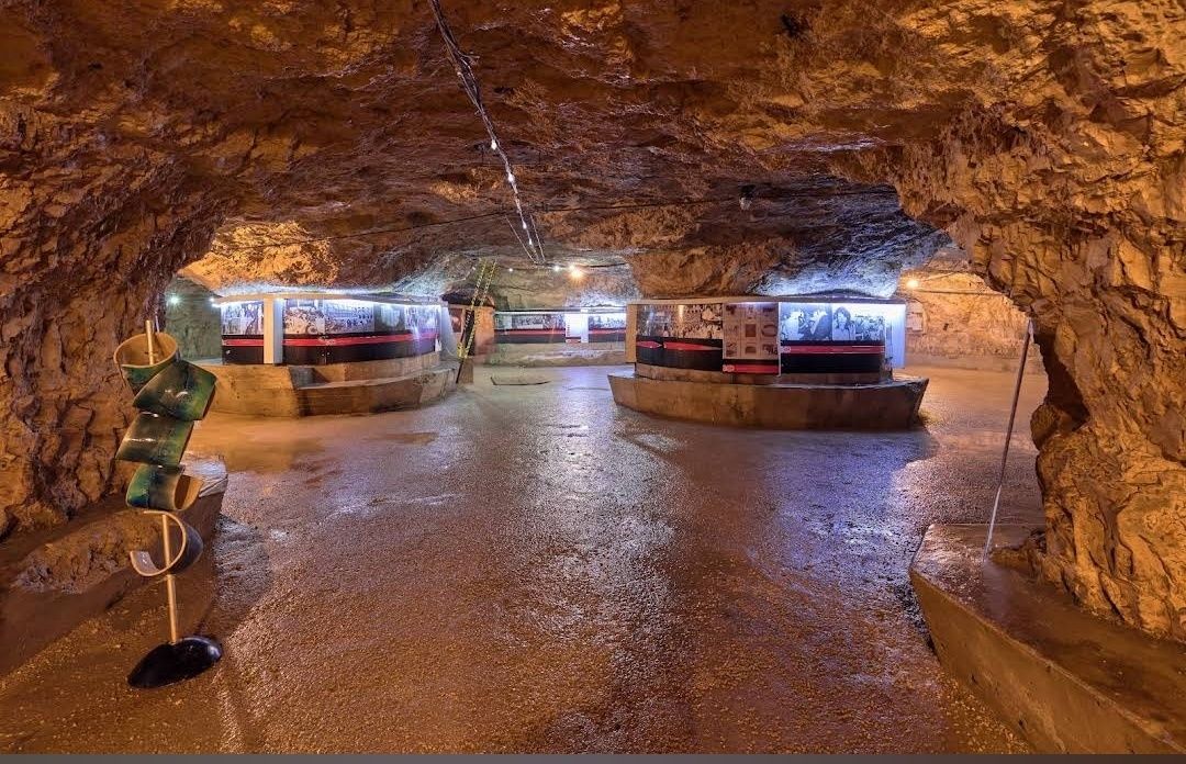
## Description **Zerostrasse** is one of the most intriguing attractions in Pula, Croatia—a vast underground tunnel system built during the early 20th century. Constructed by the Austro-Hungarian Empire during World War I, the tunnels were designed as air raid shelters and storage spaces to protect the population and military resources in case of bombings. Today, this subterranean network has been transformed into a historical site and cultural venue, giving visitors a rare glimpse into the city’s wartime past. What makes Zerostrasse unique is its **labyrinth-like layout**, stretching under Pula’s historic city center. The tunnels connect several important points of the city, including the central hill where Pula’s Venetian fortress is located. Walking through the underground passages feels like stepping back in time, with cool stone walls and dim lighting creating an atmosphere that is both mysterious and fascinating. A little-known fact is that the tunnels were engineered to hold up to **50,000 people**, which was nearly the entire population of Pula at the time. Another interesting detail is that today, parts of Zerostrasse are used as exhibition spaces, often hosting displays about Pula’s history, photography collections, and cultural events. ## Location Zerostrasse is located in **Pula**, a coastal city in **Istria, Croatia**, well-known for its Roman amphitheater and ancient heritage. The tunnels run beneath the **central hill of Pula**, with multiple entrances around the city. One of the main access points is near the **Venetian fortress (Kaštel)**, making it easy to combine a visit to both attractions. Getting there is simple. If you’re already in Pula, the entrances are within walking distance of the main city square and other landmarks. Visitors coming from outside the city can reach Pula by car, bus, or train. The **Pula Airport** also connects the city with several European destinations, and from there, the city center is just a 15-minute drive. ## Tips Here are some useful tips for enjoying your visit to Zerostrasse: * **Wear comfortable shoes** – The tunnels involve some walking, and the ground may be slightly uneven. * **Bring a light jacket** – The underground passages are cooler than the outside, even in summer. * **Check for exhibitions** – Before your visit, see if there are any ongoing cultural or art displays inside the tunnels. * **Visit the fortress too** – Since Zerostrasse is connected to the Venetian fortress, it’s worth combining both for a full historical experience. * **Allow time for exploration** – While the tunnels aren’t endless, you’ll want to spend at least an hour exploring and reading the exhibits. * **Good for hot days** – On particularly warm summer afternoons, the tunnels offer a refreshing escape from the heat. ## Conclusion **Zerostrasse in Pula** is more than just a network of tunnels—it’s a living piece of history that tells the story of the city’s strategic importance during wartime. With its unique underground passages, cool atmosphere, and cultural exhibitions, it’s a fascinating stop for history buffs, families, and curious travelers. By visiting Zerostrasse, you not only explore Pula from below but also gain a deeper appreciation for its resilience and heritage. ## FAQ **1. What was Zerostrasse originally built for?** It was constructed during World War I by the Austro-Hungarian Empire as an air raid shelter and storage facility. **2. How big is the Zerostrasse tunnel system?** The tunnels cover a large portion beneath Pula’s city center and were built to accommodate up to 50,000 people. **3. Can tourists visit the tunnels?** Yes, Zerostrasse is open to visitors, with guided tours and exhibitions available throughout the year. **4. How long does a visit take?** Most visits last about 45 minutes to an hour, depending on how much time you spend exploring exhibitions. **5. Is Zerostrasse suitable for children?** Yes, children can visit the tunnels, and many enjoy the sense of adventure, though very young kids may find the dark passages intimidating. **6. When is the best time to visit?** The tunnels are open year-round, but they are particularly enjoyable in summer when the cool underground air provides relief from the heat. ## Links * [Pula Tourist Board – Official Website](https://www.pulainfo.hr)
GemVoyage Team • World
Cairo
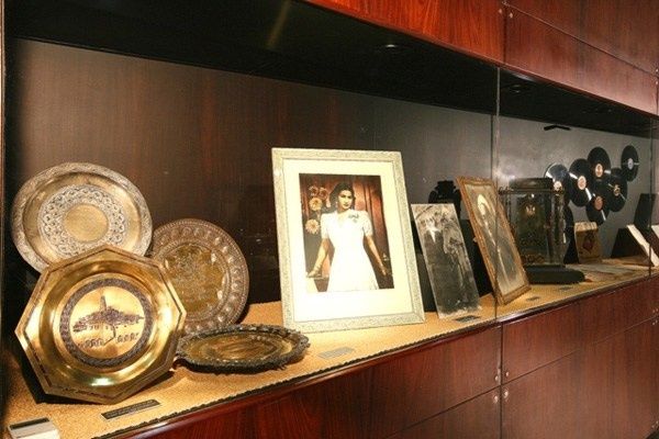
## Description **The Umm Kulthum Museum (متحف أم كلثوم)** is a cultural institution dedicated to the life, career, and enduring influence of **Umm Kulthum**, widely regarded as the greatest singer in Arabic music history. More than a traditional museum, it functions as a space of collective memory, honoring an artist whose voice shaped Arab identity, politics, and emotional life throughout the 20th century. The museum traces Umm Kulthum’s journey from her rural childhood in the Nile Delta to her rise as an international cultural icon. Exhibits include original concert dresses, handwritten song lyrics, personal letters, musical instruments, photographs, and rare recordings. These objects illustrate not only her artistic evolution but also her role in Egypt’s political and social life, particularly during the mid-20th century when her songs became symbols of unity and resilience. One lesser-known fact is that Umm Kulthum maintained strict control over her performances, including acoustics, orchestra placement, and radio broadcasts, contributing to the unique emotional intensity of her concerts. Another interesting detail is that her monthly live radio performances once caused streets across the Arab world to empty, as listeners gathered around radios to hear her sing in real time. The museum also emphasizes her collaboration with major composers and poets, such as **Riad Al-Sunbati** and **Ahmed Rami**, highlighting how her success was the result of a disciplined artistic network rather than solo fame. Audio stations throughout the museum allow visitors to experience her music in context, making the visit immersive rather than purely visual. ## Location **Country:** Egypt **Region:** Greater Cairo **City:** Cairo **District:** Old Cairo (Manial area) The museum is located within the **Manasterly Palace complex** on **Roda Island**, overlooking the Nile. ### How to Get There * **By taxi or ride-hailing:** * Uber and local taxis are the most convenient way to reach Roda Island. * **By metro:** * Take Line 1 to **Sayeda Zeinab** station, followed by a short taxi ride. * **By car:** * Accessible via bridges connecting Roda Island to central Cairo. * **On foot (limited):** * Walking access is possible from nearby neighborhoods, but distances can be long. ## Tips * **Allow time for listening stations:** The audio exhibits are essential to the experience. * **Combine with Manial Palace:** Both sites are in the same complex and complement each other well. * **Visit on a weekday:** The museum is quieter and more contemplative. * **Background knowledge helps:** Familiarity with Umm Kulthum’s music enhances the visit, but it’s not required. * **Photography rules vary:** Check signage before taking photos inside. * **Best for mature visitors:** The museum is most appreciated by those interested in cultural history and music. ## Conclusion The Umm Kulthum Museum preserves the legacy of a voice that transcended music to become a cultural force. Through personal artifacts, recordings, and historical context, it offers a deep and respectful exploration of an artist who shaped generations across the Arab world. ## FAQ **1. Who was Umm Kulthum?** She was an Egyptian singer and cultural icon whose influence extended across the Arab world for decades. **2. Is the museum suitable for non-Arabic speakers?** Yes. Visual displays and contextual explanations make the visit accessible, though understanding Arabic lyrics adds depth. **3. How long does a visit take?** Around **60 to 90 minutes**. **4. Is there an entrance fee?** Yes, a modest fee is charged. **5. Are guided tours available?** Occasionally, especially for cultural groups. **6. Can I buy music or souvenirs there?** Limited merchandise may be available within the palace complex. ## Links * [Cairo tourism portal](https://www.experienceegypt.eg/en)
GemVoyage Team • World

Comments