GemVoyage Team • World
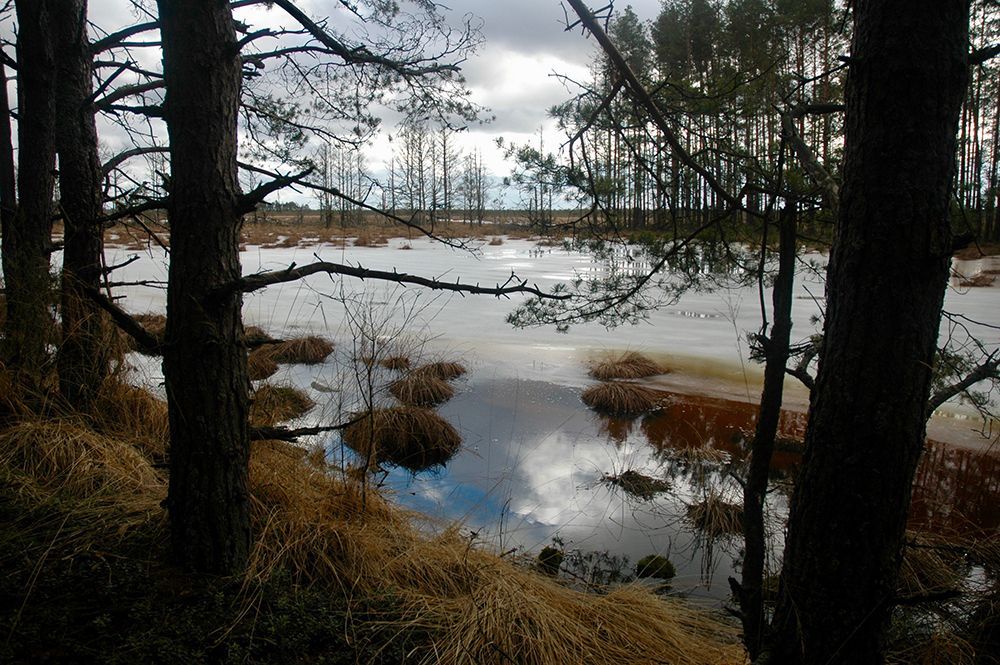
Beyond its visible beauty, Čepkeliai is scientifically invaluable. The peat layers here have accumulated over millennia, trapping pollen, seeds, and macrofossils that give researchers a continuous record of past vegetation and climate. That archive helps reconstruct regional environmental history and informs conservation decisions today. The bog’s intact hydrology—its network of raised surfaces and water-filled hollows—supports unique ecological processes, from specialized plant communities to breeding cycles for rare birds.
Although the terrain looks invitingly wild, it’s also extremely fragile. Walking off designated paths can crush sphagnum carpets and disturb microhabitats that take decades to recover. To balance access with protection, visitation in Čepkeliai is carefully managed: boardwalks, observation platforms, and tightly controlled trails concentrate human presence on durable surfaces and minimize harm. This measured approach preserves the bog’s ecological integrity while still allowing people to experience its unusual beauty and quiet drama.
For photographers, botanists, and birdwatchers the bog offers intimate encounters with species and textures rarely seen outside specialized reserves. In spring and summer, sunlit pools mirror cloudscapes and dragonflies patrol the grassy margins. Autumn brings a palette of muted reds, golds, and moss greens; winter covers the place in a hush of snow and ice that highlights the bog’s sculptural shapes. Guided walks—often led by local naturalists—are invaluable for understanding the subtle signs of bog life and the reasons for strict protection.
How to get there: the most practical route for independent travelers is to drive from Varėna, following local roads into the reserve’s access points. Some conservation organizations and local guides run organized excursions from Varėna and nearby towns; these are often the best option if you don’t have a car. Public transport options are limited and may require additional local transfers and walking; if you rely on buses, plan carefully and allow extra time. In many cases, visiting with an experienced guide not only eases logistics but also improves the interpretive experience—guides can point out rare species and explain the bog’s geological story.
Q: Are guided tours available?
A: Yes. Organized guided nature walks are often offered by conservation groups or local guides; they improve the experience and reduce ecological impact.
Q: When is the best time to visit for wildlife viewing?
A: Spring and early summer are excellent for bird activity and insect life; early morning and late afternoon offer better sightings and softer light for photography.
Q: Is the bog safe for solo visitors?
A: The area is generally safe, but the remoteness and fragile terrain mean solo visits are best for experienced, well-prepared hikers; joining a guided walk is recommended for most visitors.
Q: Can I take photographs or drones in the reserve?
A: Photography from boardwalks and platforms is usually permitted; drones are commonly restricted to prevent disturbance—check reserve rules in advance.
Q: Are there facilities nearby?
A: Facilities are limited; plan for basic needs (water, layers, footwear) and expect minimal infrastructure near the main access points.
Discover more hidden gems you might love.
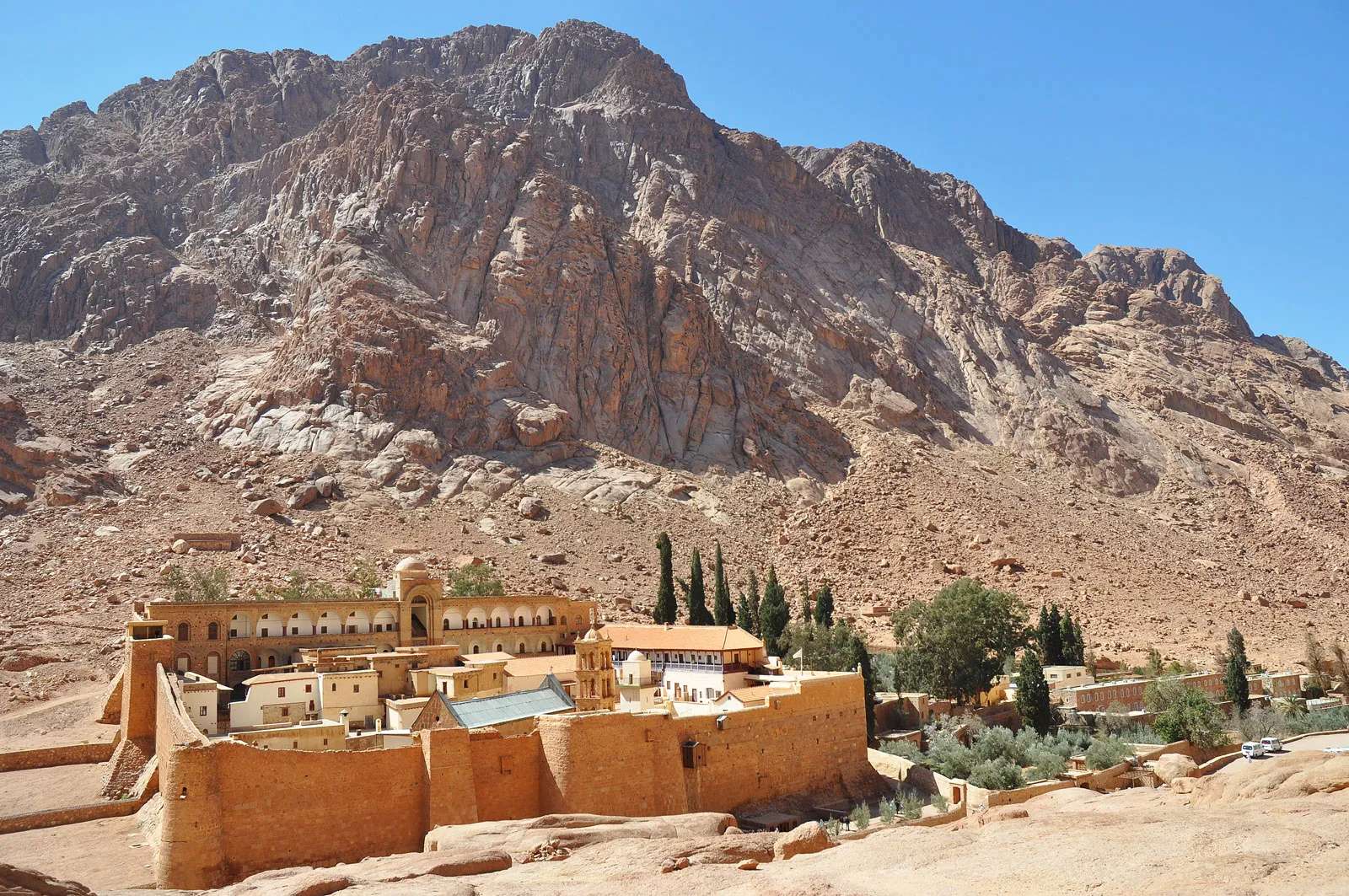
Sinai
## Description Mount Catherine (Jebel Katherîn) is the highest peak in Egypt, rising to an elevation of 2,629 meters (8,625 feet) above sea level. Nestled in the rugged terrain of the southern Sinai Peninsula, this majestic mountain offers not only breathtaking views but also a deep spiritual and historical resonance. It’s named after Saint Catherine of Alexandria, whose remains were said to have been miraculously transported to the summit by angels. Today, it’s a popular destination for hikers, pilgrims, and adventurers seeking solitude, challenge, and connection to ancient traditions. Unlike the more frequented Mount Sinai (Jebel Musa), which is traditionally associated with Moses receiving the Ten Commandments, Mount Catherine is quieter and less commercialized. The summit rewards climbers with panoramic views of the surrounding desert and mountains, often blanketed in snow during winter—a rare sight in Egypt. At the peak, a small chapel dedicated to Saint Catherine stands as a testament to the mountain’s religious significance. A little-known fact: the mountain is part of the Saint Catherine Protectorate, Egypt’s largest nature reserve, which is home to rare flora and fauna, including Nubian ibex and Sinai agamas. Another intriguing detail is that the summit’s chapel is one of the highest Christian shrines in the Middle East. ## Location Mount Catherine is located in **Egypt**, within the **South Sinai Governorate**, near the town of **Saint Catherine**. It lies in the heart of the Sinai Peninsula, surrounded by dramatic granite peaks and desert valleys. ### How to Get There: - **By Car**: From Cairo, it’s approximately a 6–8 hour drive via the Suez Tunnel and through the desert highways. From Sharm El-Sheikh, the drive takes about 3–4 hours. - **By Bus**: Regular buses run from Cairo and Dahab to Saint Catherine town. From there, local guides can arrange transport to the trailhead. - **By Tour**: Many adventure and pilgrimage tours include Mount Catherine in their itinerary, often combined with visits to Mount Sinai and Saint Catherine’s Monastery. It’s recommended to travel with a licensed guide, especially for the hike, as the terrain can be challenging and weather conditions unpredictable. ## Tips for Visitors To make the most of your Mount Catherine experience, consider these tips: - **Start Early**: Begin your hike before dawn to reach the summit by sunrise. The views are spectacular, and temperatures are cooler. - **Hire a Local Guide**: Guides from Saint Catherine town are knowledgeable and can enhance your experience with historical and cultural insights. - **Dress in Layers**: Even in summer, temperatures can drop significantly at higher elevations. Bring warm clothing and sturdy hiking boots. - **Bring Supplies**: Carry water, snacks, a flashlight, and a first aid kit. There are no facilities on the trail. - **Respect the Environment**: The area is ecologically sensitive. Stick to marked paths and avoid littering. - **Visit the Monastery**: Saint Catherine’s Monastery, located nearby, is one of the oldest Christian monasteries in the world and a UNESCO World Heritage Site. ## Conclusion Mount Catherine is a place of awe-inspiring beauty and spiritual depth. Whether you're drawn by its status as Egypt’s highest peak or its sacred legacy, the mountain offers a rewarding journey into nature, history, and reflection. ## FAQ **1. How long does it take to hike Mount Catherine?** The hike typically takes 6–8 hours round trip, depending on your pace and weather conditions. **2. Is Mount Catherine harder to climb than Mount Sinai?** Yes, it’s more challenging due to its elevation and less-developed trails. It’s recommended for experienced hikers. **3. Can I hike Mount Catherine without a guide?** While possible, it’s not advisable. The terrain is remote and can be confusing. A guide ensures safety and enhances the experience. **4. Is there accommodation near Mount Catherine?** Yes, the town of Saint Catherine offers guesthouses and eco-lodges catering to hikers and pilgrims. **5. What’s the best time to visit?** Spring (March–May) and autumn (September–November) offer the best weather. Winter can be cold and snowy, while summer is extremely hot. **6. Are there religious services at the summit chapel?** Occasionally, special services are held, but it’s not staffed regularly. Visitors are welcome to enter and reflect. ## Links - [Saint Catherine’s Monastery – Official Site](https://sinaimonastery.com/index.php/en)
GemVoyage Team • World
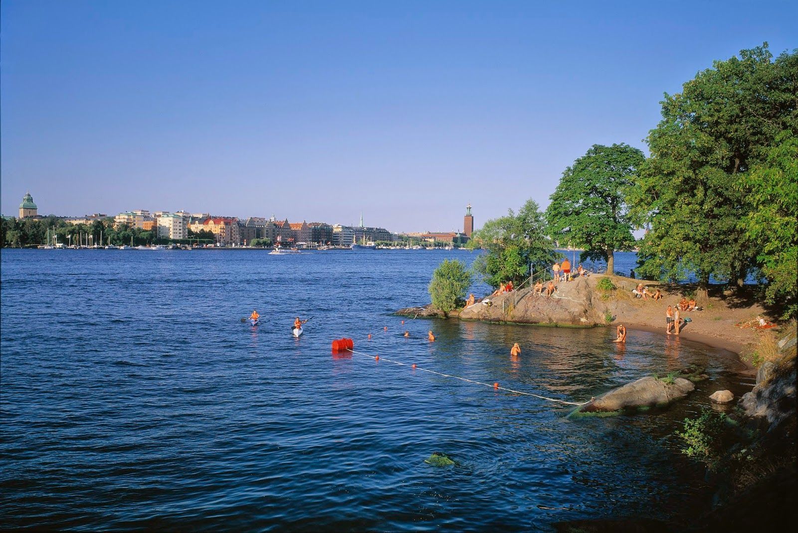
Stockholm
## Description Långholmen Island Beach is one of Stockholm’s most appealing summer spots because it combines waterfront relaxation with the unusual character of an island that has shifted through different uses over time. Visitors come for swimming, sunbathing, walking, and the easygoing atmosphere, but the experience is richer than a simple beach stop. The setting itself is part of the attraction: you are on an island close to the city, surrounded by water, greenery, and reminders of Stockholm’s layered history. What makes Långholmen stand out is that it feels local rather than overly polished. It is a place where residents and visitors mingle in warm weather, where people arrive with towels, picnic food, and a plan to stay for a while. It is not a tropical beach and does not try to be one; instead, it offers a distinctly Scandinavian urban waterfront experience. One lesser-known fact is that Långholmen has had very different historical roles before becoming a leisure destination, which gives the island an added sense of depth. Another interesting detail is that the area’s appeal changes dramatically by season, making it a true summer favorite in a city where outdoor life depends heavily on weather. The beach is also a good example of how Stockholm uses its water environment. Rather than separating city life from the shoreline, the city often integrates swimming and walking areas into the urban fabric. Långholmen captures that idea perfectly. You can spend time on the beach, wander nearby paths, and still feel close to the city center. For travelers, that makes it a convenient and memorable place to balance sightseeing with rest. ## Location Långholmen is a small island in central Stockholm, Sweden, connected to the city by bridges and easy to access from the Södermalm side and other central districts. Because it is so close to the urban core, it is one of the easiest island experiences in Stockholm. The simplest way to get there is by walking from nearby central neighborhoods or using public transport and then continuing on foot. Cycling also works well in Stockholm, and the island fits nicely into a bike-friendly itinerary. Once there, most of the movement is best done on foot so you can enjoy the shoreline and the surrounding green areas at an unhurried pace. ## Tips This is best visited in warm weather, especially in late spring and summer. Bring swimwear if you want to use the beach properly, but also bring a layer for cooler winds. Combine the visit with a walk around the island so you see more than just the main swimming area. Arrive earlier on sunny days if you want a quieter spot near the water. ## Conclusion Långholmen Island Beach is a relaxed city escape that gives Stockholm a rare but very welcome summer beach mood. ## FAQ ### Is Långholmen a real beach? Yes, though it is a city beach rather than a large natural seaside beach. ### Is it good for swimming? Yes, it is one of Stockholm’s popular places for summer swimming. ### How do I get there from central Stockholm? Walk, bike, or use public transport and then cross to the island on foot. ### Is it busy in summer? It can be, especially on warm weekends and sunny afternoons. ### Can I visit outside summer? Yes, but it is most enjoyable as a beach destination in the warmer months. ## Links - [Stockholm official visitor information](https://www.visitstockholm.com/) - [Långholmen on Wikipedia](https://en.wikipedia.org/wiki/Långholmen)
GemVoyage Team • World
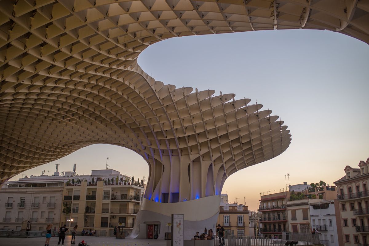
Seville
## Description Metropol Parasol, widely known as Las Setas, is one of Seville’s most striking modern landmarks and one of the clearest examples of how the city blends old and new. The structure rises above Plaza de la Encarnación with a dramatic, wave-like form that looks almost impossible at first glance. Made from timber and organized on a monumental scale, it creates a new skyline for the historic center while also serving as a public space, viewpoint, market area, and archaeological showcase. For travelers, it offers something rare: a contemporary architectural experience embedded directly in an old urban setting. What makes Metropol Parasol especially memorable is how many functions it holds at once. You can walk below it, stand under it, go up to the rooftop walkways, and also access the archaeological remains preserved underneath. That layering is a big part of its appeal. A little-known fact is that the structure is often described as one of the largest timber architectural constructions in the world, which gives it a technical significance beyond its visual impact. Another detail many visitors miss is that the underside and surrounding plaza change character depending on the time of day, with morning, afternoon, and night each creating a different mood around the same structure. For visitors who think of Seville only in terms of churches, palaces, and traditional patios, Metropol Parasol offers a useful correction. It shows that the city still experiments, still reinvents public space, and still uses architecture to make a statement. It is not only photogenic; it is conceptually important. The combination of modern design, archaeological depth, and rooftop views makes it one of the city’s most distinctive attractions for travelers who want a wider sense of Seville than the classic route alone provides. ## Location Metropol Parasol is located in Plaza de la Encarnación in the historic center of Seville, Andalusia, Spain. Because it sits in such a central area, it is easy to reach on foot from many of the city’s main sights. Visitors staying in the old town can often walk there directly, while buses and taxis provide easy access from farther away. The structure is also well positioned for combining with nearby shopping streets, tapas stops, and other central landmarks. If you are planning to go up to the top, try to visit at a time when the light is good and the city is not overwhelmingly crowded. The rooftop is especially rewarding near sunset, when the view across Seville becomes more dramatic. If you are more interested in the archaeological and urban-planning side of the site, a daytime visit can be just as worthwhile. Either way, the location makes it simple to fold into a broader sightseeing route without needing a special excursion. ## Tips - Go up to the rooftop for the best panoramic view of the historic center. - Visit near sunset if you want the most impressive light. - Don’t skip the lower level, where the archaeological remains add historical depth. - Pair the visit with nearby food or shopping to make the most of the central location. - Bring sun protection in warm months, because the plaza can be bright and exposed. - Visit at night as well if you want to see how the structure changes with illumination. ## Conclusion Metropol Parasol is one of Seville’s most original landmarks, combining modern architecture, public space, and historical layers in a single unforgettable site. It is a strong stop for travelers who want both views and design. ## FAQ ### Why is Metropol Parasol important? It is important as a bold example of contemporary architecture in Seville and as a multi-use public space. ### Can visitors go to the top? Yes. The rooftop walkways and viewpoints are one of the main reasons to visit. ### Is it good for photos? Very much so. The structure, plaza, and views offer excellent photo opportunities. ### How long does a visit take? About one hour is common, though you may stay longer if you explore the full site and surrounding area. ## Links - [Official website](https://setasdesevilla.com/) - [Wikipedia](https://en.wikipedia.org/wiki/Metropol_Parasol) - [Seville tourism information](https://www.visitasevilla.es/en)
GemVoyage Team • World

Moscow
## Description Winzavod Art Center is one of Moscow’s most important contemporary cultural destinations because it transformed an industrial site into a living arts quarter. Located in a former winery complex, it combines galleries, studios, exhibition spaces, design shops, and creative institutions in an environment that feels both raw and intentionally curated. For visitors interested in contemporary art, design, urban regeneration, or Moscow’s creative scene, it is an essential stop. What makes Winzavod especially compelling is the way the setting shapes the experience. The industrial architecture gives the center a strong visual identity, and the reuse of the space reinforces the idea that art can emerge from older urban infrastructure rather than only from formal museum buildings. A lesser-known fact is that Winzavod has played a major role in Moscow’s contemporary art ecosystem, helping to establish a more visible platform for galleries, experimental projects, and creative communities. Another detail many travelers appreciate is that the site does not feel like a single static institution. It often feels like a district within the city, with overlapping uses and constantly changing cultural energy. For visitors, the attraction is not just the exhibitions but the atmosphere of making and experimentation. You can encounter established artists, emerging voices, design-driven retail, and a kind of creative density that is difficult to find in more conventional museums. This gives the center a special value for travelers who want to understand how Moscow’s cultural life operates in the present tense, not only through its imperial or Soviet past. Winzavod also works well because it is approachable. You do not need specialist knowledge to enjoy the visit. Even if you are not deeply immersed in contemporary art, the setting, programming, and urban energy make it a stimulating place to spend time. ## Location Winzavod Art Center is located in Moscow, Russia, in the city’s central creative and industrial-adjacent area. Its position makes it accessible from major parts of the city while still retaining a distinct identity separate from the classic tourist circuit. Because it is part of a larger former industrial complex, the site feels like a destination rather than a simple gallery visit. The easiest way to reach it is by Moscow Metro followed by a short walk, though taxis and rideshares are also practical. Once there, the best approach is to move slowly through the complex and check the current exhibition mix. Since the site often hosts multiple galleries and spaces, the experience can vary depending on the day. If you are building a broader Moscow itinerary, Winzavod pairs well with other contemporary or alternative cultural stops, as well as food and coffee breaks in the surrounding area. ## Tips Check current exhibitions before going. The experience is best when you know what is showing. Allow time for wandering. The site rewards exploration across multiple spaces rather than a quick single-room visit. Pay attention to the architecture. The industrial shell is a major part of the atmosphere. If you enjoy design, books, or independent retail, give yourself time to browse beyond the exhibitions. Use it as a contrast to Moscow’s older heritage sites. The juxtaposition makes the city feel more complete. ## Conclusion Winzavod Art Center is one of Moscow’s most distinctive creative spaces, blending contemporary art with industrial architecture and a strong urban identity. It is ideal for travelers who want to see the city’s present-day cultural energy. ## FAQ ### Is Winzavod only for contemporary art specialists? No. It is accessible to general visitors and works well even if you are simply curious about Moscow’s creative scene. ### How much time should I spend there? Around 1.5 to 3 hours, depending on how many galleries and spaces are open when you visit. ### Is it easy to reach from central Moscow? Yes. Metro access makes it relatively straightforward. ### What makes it different from a normal museum? It is more of a cultural complex than a single museum, with a stronger sense of creative ecosystem and adaptive reuse. ## Links - [Winzavod official site](https://winzavod.ru/eng/)
GemVoyage Team • World
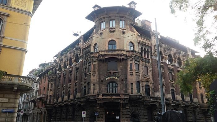
Milan
## Description The **Quadrilatero del Silenzio** is one of Milan’s most refined and least touristy architectural districts, a compact residential enclave where **Art Nouveau elegance, early 20th-century symbolism, and aristocratic discretion** converge. Unlike Milan’s grand monumental zones such as the Duomo or Brera, this area is defined by **silence, privacy, and restrained beauty**. It feels less like a destination and more like a secret revealed only to those who actively search for it. The name “Quadrilatero del Silenzio” loosely translates to **“The Quadrilateral of Silence”**, referencing both its **four bordering streets** and the **notable absence of commercial noise and mass tourism**. The district dates primarily to the **early 1900s**, when Milan was undergoing rapid modernization and wealthy families commissioned architects to design villas and palazzi inspired by **Liberty style**, Italy’s version of Art Nouveau. Among the district’s architectural highlights are **Casa Galimberti, Casa Guazzoni, and Palazzo Berri-Meregalli**. These buildings showcase extraordinary decorative detail: floral ironwork, painted ceramic tiles, sculpted balconies, symbolic reliefs, and richly textured façades. Casa Galimberti in particular stands as one of the **most complete Art Nouveau residential structures in Italy**, with its exterior entirely clad in painted ceramic panels depicting allegorical scenes and classical figures. What makes the Quadrilatero del Silenzio especially distinctive is its **spiritual and symbolic undercurrent**. Palazzo Berri-Meregalli, one of the most visually dramatic buildings in the area, incorporates **mystical and occult motifs**, skulls, grotesque faces, and symbolic sculptures linked to esoteric traditions. This hidden symbolic language contrasts sharply with the district’s otherwise calm residential purpose, adding a layer of intrigue beneath the formal elegance. The neighborhood’s emotional atmosphere is **measured and withdrawn**. Tree-lined streets, soft façades, and limited vehicle traffic create a mood unlike the rest of central Milan. There are no major shops, cafés, or attractions competing for attention. Instead, visitors move slowly, examining balconies, doorways, tiled surfaces, and wrought-iron gates just meters from inhabited private homes. This blurs the boundary between **museum-like observation and daily life**. A little-known fact is that Casa Guazzoni’s balcony sculptures were among the **earliest experiments with reinforced concrete sculpture in Milan**, hidden beneath their decorative surfaces. Another lesser-known detail is that much of the district was deliberately zoned as **high-end residential from the outset**, preventing later commercial overdevelopment and preserving its original function for more than a century. Unlike Milan’s fashion districts or historic centers, the Quadrilatero del Silenzio does not sell an experience. It **offers stillness**. It rewards visitors who pay attention to surface texture, ornamental language, and architectural storytelling rather than spectacle. This makes it particularly appealing to architects, photographers, design students, and travelers who prefer subtlety over highlights. The district is not large, and it does not aim to be. Its power lies in **concentration rather than scale**. Within a few blocks, it condenses many of the ideals of Milan’s early modern identity: wealth, experimentation, decorative craftsmanship, and discreet urban living. ## Location The **Quadrilatero del Silenzio** is located in the **eastern part of central Milan**, just outside the city’s main historical core. **City:** Milan **Region:** Lombardy (Lombardia) **Country:** Italy **Main Streets Defining the Area:** * Via Cappuccini * Via Serbelloni * Via Mozart * Via Malpighi ### How to Get There: * **By metro:** * **Line M1 (red line)** to **Porta Venezia Station**, then a 5–8 minute walk. * **By tram:** Several tram lines run through Corso Venezia and Porta Venezia. * **By taxi or ride-hailing:** Direct access with easy drop-off near Via Mozart or Via Cappuccini. * **On foot:** A pleasant walk from the fashion district or the Natural History Museum. The area is ideal to combine with nearby attractions such as **Porta Venezia, Indro Montanelli Public Gardens, and Corso Buenos Aires**. ## Tips * **Visit during daylight:** Architectural details are best visible in natural light. * **Keep voices low:** It is a residential area known for its quiet character. * **Photography is allowed, but be discreet:** Many buildings are private homes. * **No cafés inside the core area:** Plan coffee stops in nearby Porta Venezia. * **Look up as much as you look forward:** Balconies and upper façades hold the most details. * **Best for architecture lovers:** It is not a shopping or entertainment zone. * **Pair it with a museum visit:** The Natural History Museum nearby fits the reflective mood. * **Avoid peak commuter hours:** Traffic is limited but narrow streets amplify sound. ## Conclusion The **Quadrilatero del Silenzio** is one of Milan’s most understated yet culturally dense districts. It reveals a side of the city built not for spectacle but for **craft, symbolism, and quiet luxury**. Through its Art Nouveau façades, discreet streets, and hidden esoteric details, it tells a story of Milan at the dawn of modernity, preserved in a state of rare urban restraint. ## FAQ **1. What is the Quadrilatero del Silenzio?** It is a **small residential architectural district** in Milan known for its Art Nouveau buildings and quiet atmosphere. **2. Why is it called “del Silenzio”?** Because of its **low traffic, lack of commercial noise, and calm residential character**. **3. Is it free to visit?** Yes. It is a **public neighborhood with no entrance fee**. **4. How long does a visit usually take?** Most visitors spend **30 to 60 minutes** walking through the area. **5. Is it good for photography?** Yes, especially for **architectural and detail photography**, though discretion is expected. **6. Is it suitable for families?** Yes, but it is better suited to **slow walking and observation** rather than activities for children. ## Links * [Comune di Milano – Urban Heritage](https://www.comune.milano.it)
GemVoyage Team • World
Milan
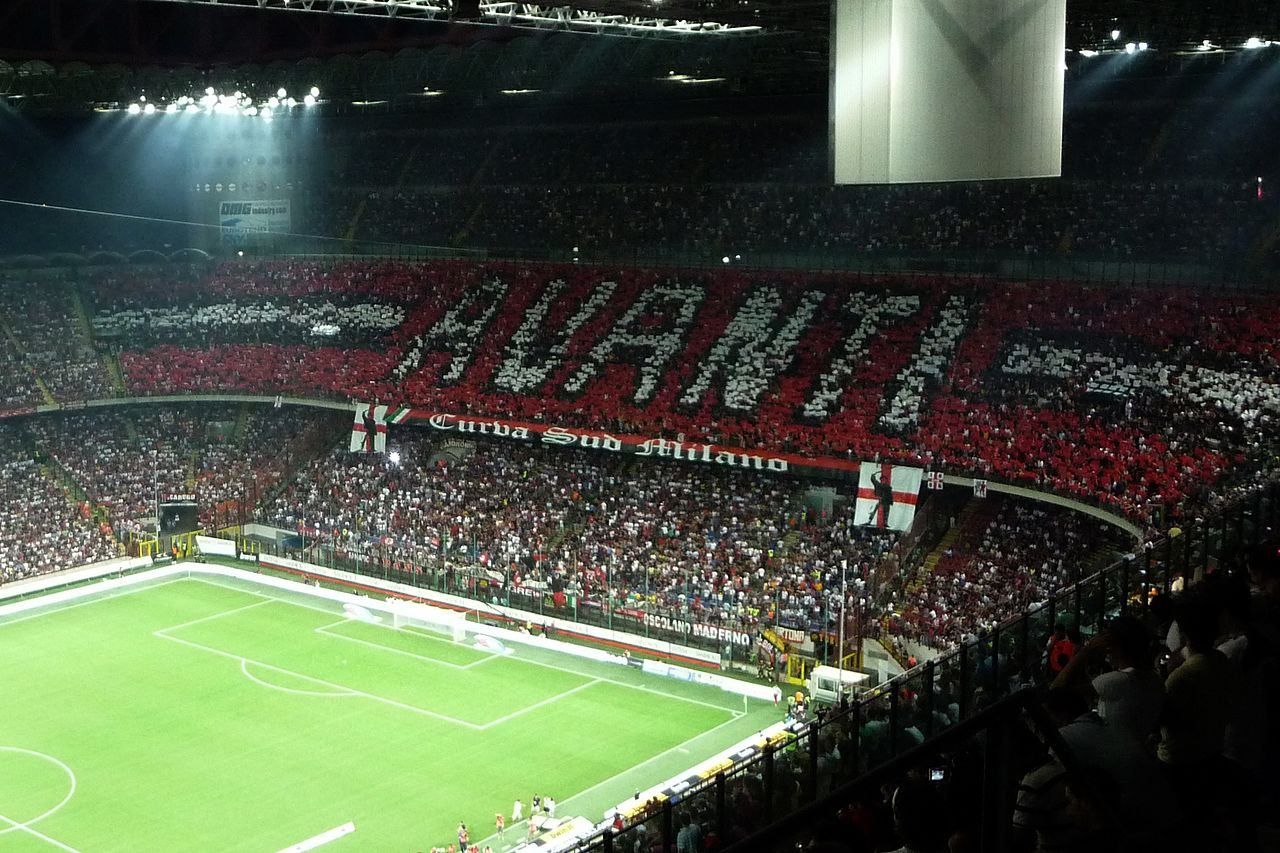
## Description The **San Siro Stadium**, officially named **Stadio Giuseppe Meazza**, is one of the most legendary football arenas in the world — a true **temple of sport and passion**. Located in the heart of **Milan**, Italy’s fashion and football capital, San Siro stands as a colossal monument to the city’s competitive spirit and shared love for the beautiful game. Originally inaugurated in **1926**, the stadium was built under the direction of **Piero Pirelli**, then-president of **A.C. Milan**, and was later named after **Giuseppe Meazza**, one of Italy’s most celebrated footballers who played for both **A.C. Milan** and **Inter Milan**. Over the decades, it has undergone multiple renovations, including major updates in **1955**, **1990** (for the FIFA World Cup), and **2015**, giving it the imposing, futuristic appearance it has today. With a seating capacity of over **75,000 spectators**, San Siro is Italy’s **largest stadium** and one of the most atmospheric in Europe. Its distinctive **spiral towers** and red roof beams are architectural icons, visible from across the city skyline. Inside, the steep stands ensure that fans feel incredibly close to the pitch — creating an electric atmosphere during matches, especially when **A.C. Milan** and **Inter Milan** face off in the legendary **Derby della Madonnina**. Beyond football, San Siro has hosted countless **historic events**, from **FIFA World Cup** and **UEFA Champions League** finals to concerts by international superstars like **U2, Coldplay, and Beyoncé**. Few stadiums in the world can match its mix of **sporting heritage and cultural influence**. A lesser-known fact is that the **stadium has its own museum**, the **San Siro Museum**, dedicated to the history of Milan’s two football clubs. Visitors can explore trophies, jerseys, and memorabilia from more than a century of football history — and even step into the players’ tunnel and onto the field itself, experiencing what legends once did. While discussions continue about a possible **new stadium** in the coming years, San Siro remains a beloved landmark — a living piece of Milanese identity and an enduring shrine to Italian football glory. ## Location The **San Siro Stadium (Stadio Giuseppe Meazza)** is located in the **San Siro district**, in the **northwestern part of Milan**, **Lombardy**, **Italy**. **Address:** Piazzale Angelo Moratti, 20151 Milano MI, Italy To get there: * **By metro:** Take **Line M5 (Lilac Line)** to **San Siro Stadio Station**, located just steps from the stadium entrance. * **By tram:** Line **16** (direction San Siro) stops directly outside the venue. * **By bus:** Lines **49, 64, 78, 80, 98,** and **423** all serve the stadium area. * **By car:** Accessible from **Viale Caprilli** or **Via Novara**, though parking can be limited on match or concert days. * **By bike or scooter:** Milan’s **bike-sharing and e-scooter services** have designated parking zones near the stadium. ## Tips * **Book tickets early:** Matches, especially the **Derby della Madonnina**, sell out quickly. Buy tickets through official club websites or authorized partners. * **Take the stadium tour:** Visit the **San Siro Museum**, explore locker rooms, and walk through the players’ tunnel onto the field. * **Arrive early:** On match days, the area fills with fans, street food stands, and merchandise stalls — a festive pre-game experience. * **Check the schedule:** Even if no match is on, the **museum and tour** are open most days. * **Use public transport:** Parking is limited, so the **M5 metro** line is the most convenient and efficient way to get there. * **Stay for the atmosphere:** The energy of Italian fans, complete with chants, banners, and flares, makes every match unforgettable. * **Bring ear protection for children:** The volume during matches can be intense, especially in the Curva Sud and Curva Nord sections. * **Combine with nearby attractions:** Visit **Casa Milan (A.C. Milan headquarters)** or enjoy the nearby **Monte Stella Park** for a relaxing contrast to the excitement. ## Conclusion The **San Siro Stadium** is more than just a sports venue — it’s the **heart of Milanese football culture** and a symbol of Italian pride. From hosting world-class matches to staging concerts for thousands of fans, San Siro has witnessed nearly a century of unforgettable moments. Its towering architecture, roaring crowds, and legendary rivalries make it a must-see destination for anyone visiting Milan. Whether you’re a devoted football fan or simply curious about the passion that drives Italy’s sporting soul, a visit to San Siro is an experience you’ll never forget. ## FAQ **1. When was San Siro Stadium built?** It was inaugurated in **1926** and has undergone several major renovations since, most notably in **1955** and **1990**. **2. Why is it also called Stadio Giuseppe Meazza?** The stadium was renamed after **Giuseppe Meazza**, a famous Italian footballer who played for both Milan and Inter, in recognition of his contribution to Italian football. **3. Which teams play at San Siro?** It is home to both **A.C. Milan** and **Inter Milan (Internazionale)**. **4. How can I visit the stadium when there’s no match?** You can book a **guided tour and museum visit**, available daily except on event days. **5. What is the capacity of San Siro?** The stadium can hold approximately **75,000 spectators**, making it the **largest in Italy**. **6. Are there restaurants or shops nearby?** Yes — the surrounding area has **cafés, restaurants, and team merchandise stores**, as well as pop-up vendors on match days. **7. Is the stadium being replaced?** Plans are being discussed for a **new stadium** in the coming years, but **San Siro remains open and active** for matches and events for now. ## Links * [Official A.C. Milan Website – Tickets & Matches](https://www.acmilan.com) * [Official Inter Milan Website – Tickets & Events](https://www.inter.it) * [San Siro Stadium Tour & Museum](https://www.sansirostadium.com)
GemVoyage Team • World

Comments