GemVoyage Team • World
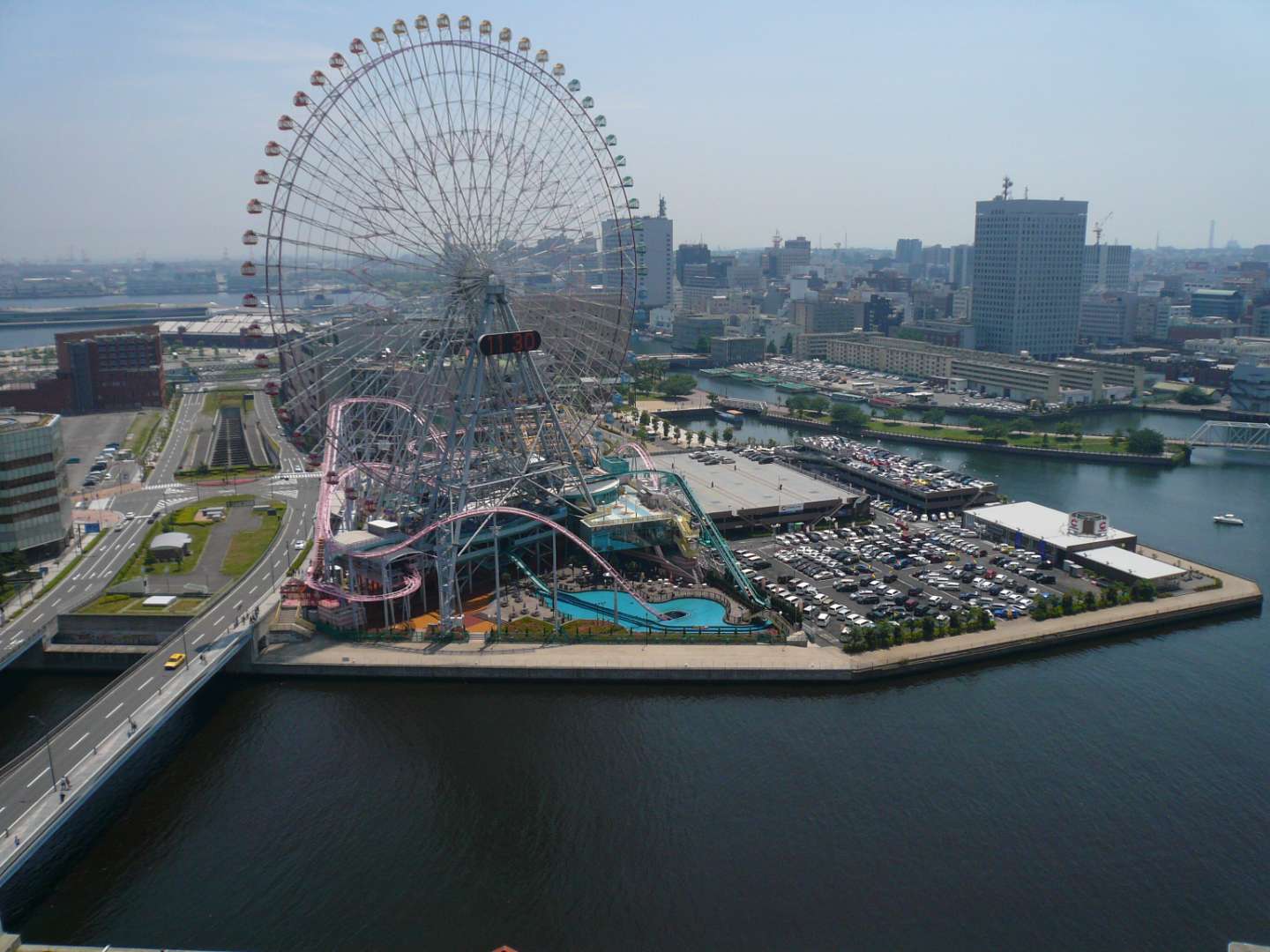
Cosmo World in Yokohama is a vibrant urban amusement park that blends thrilling rides, family-friendly attractions, and waterfront views into one unforgettable experience. Located in the heart of the Minato Mirai 21 district, this compact yet dynamic park is best known for its iconic Ferris wheel, Cosmo Clock 21, which once held the title of the world’s largest Ferris wheel with a clock. Towering over the city skyline, it offers panoramic views of Yokohama Bay and the surrounding urban landscape, especially stunning at night when the wheel lights up in dazzling colors.
The park is divided into three distinct zones: the Wonder Amuse Zone, Burano Street Zone, and Kids Carnival Zone. Each area caters to different age groups and interests. The Wonder Amuse Zone features high-adrenaline rides like the Diving Coaster: Vanish, a roller coaster that plunges into a tunnel beneath a pool of water. The Burano Street Zone offers quirky attractions such as mirror mazes and haunted houses, while the Kids Carnival Zone is perfect for younger children with gentle rides and arcade games.
A little-known fact: Cosmo World originated from the Yokohama Exotic Showcase in 1989, and the Ferris wheel was part of a temporary exhibition before becoming a permanent fixture. Another unique detail is that admission to the park is free—you only pay for the rides you choose to enjoy, making it an accessible destination for all budgets.
Cosmo World is located in Japan, in the Kanagawa Prefecture, within the city of Yokohama. It sits in the Minato Mirai 21 district, a modern waterfront area known for its shopping, entertainment, and cultural attractions.
Its central location makes it an easy addition to any Yokohama itinerary.
Cosmo World in Yokohama is a compact yet exhilarating amusement park that offers something for everyone—from heart-pounding roller coasters to scenic Ferris wheel rides. Its waterfront location, free entry, and diverse attractions make it a must-visit for families, couples, and solo travelers alike.
1. Is there an entrance fee to Cosmo World?
No, admission is free. You only pay for the rides you choose to go on.
2. What are the operating hours?
Typically, the park operates from 11:00 AM to 8:00 PM, but hours may vary seasonally or due to weather.
3. Is Cosmo World suitable for young children?
Yes, the Kids Carnival Zone is designed specifically for younger visitors.
4. Can I buy tickets online?
Ride tickets are generally purchased on-site. Some packages may be available through travel agencies.
5. Is the Ferris wheel wheelchair accessible?
Yes, Cosmo Clock 21 is accessible for wheelchair users.
6. Are food and drinks allowed inside the park?
Outside food and drinks are not permitted, but there are cafés and vending machines within the park.
Discover more hidden gems you might love.
Victoria
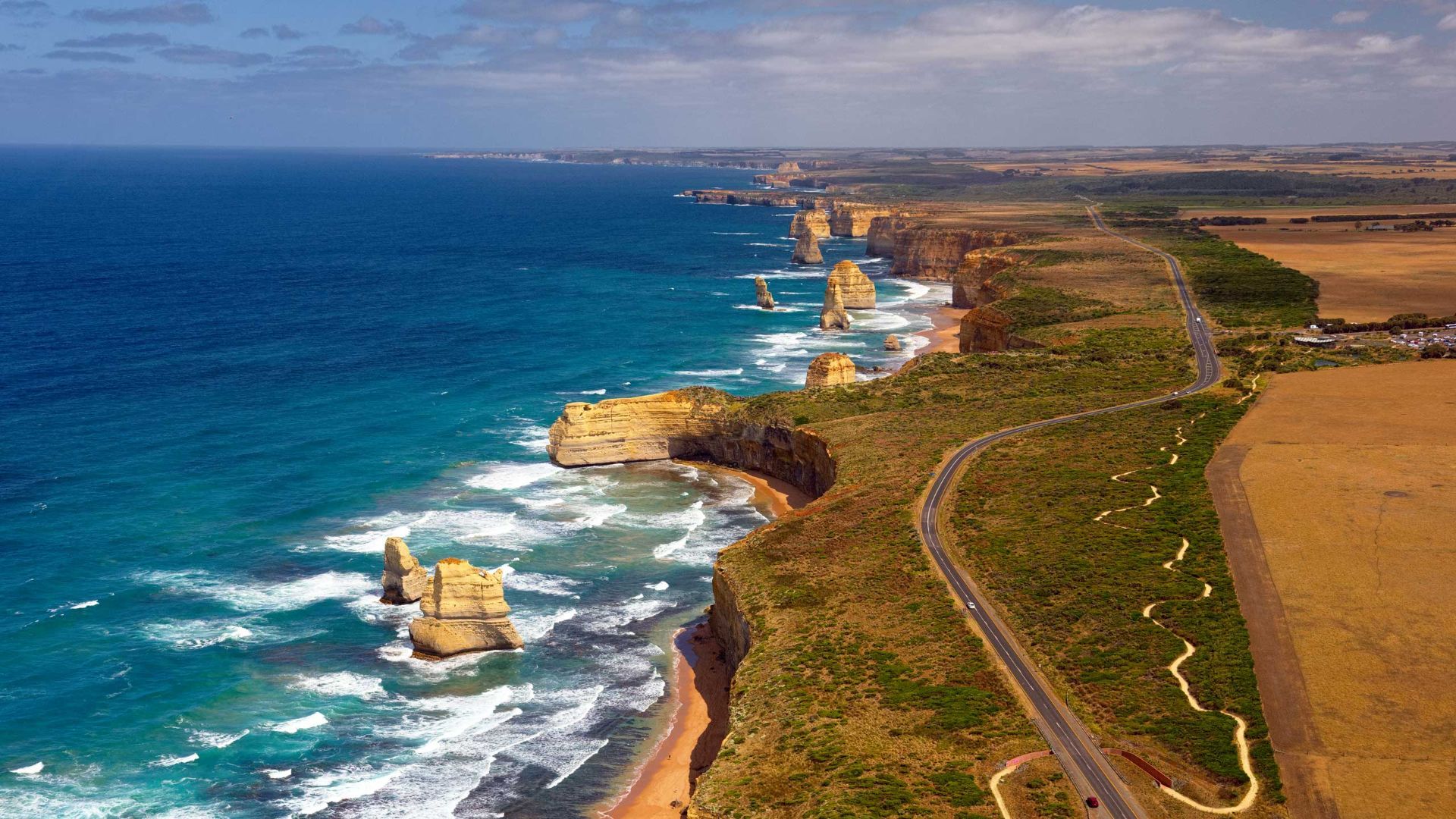
## Description The Great Ocean Road is one of the world’s most celebrated coastal drives, winding along Victoria’s southwestern shoreline past rugged cliffs, surf beaches and sculpted limestone stacks such as the Twelve Apostles. Built by returned WWI soldiers and dedicated as a war memorial, the road combines engineering, natural wonders and seaside towns with cafes, galleries and surf culture. Dramatic viewpoints, rainforest gorges (like Great Otway National Park) and wildlife sightings (koalas, kangaroos and seabirds) make the route a versatile exploration corridor. What distinguishes the route is its dramatic juxtaposition of surf, limestone geology and accessible townscapes. Photographers and road trippers prize the series of staged viewpoints where walking tracks descend to coves and panoramic platforms look out to offshore stacks. Beyond the famous stacks, the route offers fern gullies and waterfalls in the Otways, coastal walks to hidden beaches, and small towns where food and surf culture combine. Many travelers craft multi-day itineraries that combine coastal hikes, wildlife spotting and culinary stops, from coffee in Torquay to seafood in Apollo Bay and heritage-listed lookouts around Port Campbell. The road’s memorial origins also allow visitors to reflect on the engineering feat and the region’s social history while enjoying one of Australia’s most scenic drives. ## Location The Great Ocean Road runs from Torquay to Allansford near Warrnambool in Victoria, Australia, with key stops including Anglesea, Lorne, Apollo Bay and the Twelve Apostles viewpoint at Port Campbell. Melbourne is the primary gateway, roughly a 1.5–3 hour drive to the start depending on traffic. ## Tips - **Avoid peak holiday traffic and plan overnight stops:** The route is popular during Australian school holidays; split the drive into staged stops to avoid fatigue and to enjoy hikes. - **Plan time for short walks and lookout detours:** Many of the best views require small detours and short walks; factor these into your itinerary rather than only driving. - **Mind driving conditions and seasonal weather:** Wind, sea spray and rain can change conditions quickly — watch for strong crosswinds and take care on narrow coastal roads. - **Book accommodation and tours in advance during peak season:** Lorne, Apollo Bay and Port Campbell fill quickly in summer — reserve ahead if travel dates are fixed. - **Pack layers and photography gear:** Coastal light changes quickly; bring windproof layers, a tripod for sunrise/sunset shots and protective gear for salt spray. ## Conclusion The Great Ocean Road pairs dramatic coastal geology with accessible townscapes and outdoor experiences, making it an essential Australian road trip for nature lovers and photographers. Thoughtful pacing and an eye for sidetracks reveal quieter coves, rainforest secrets and local food scenes that complement the iconic seascapes. ## FAQ - **Q: How long does the full drive along the Great Ocean Road take?** A: The direct driving time without stops is around 6–7 hours, but most travelers allocate 2–3 days to properly enjoy walks, viewpoints and coastal towns. - **Q: Can I drive the Great Ocean Road in a single day from Melbourne?** A: You can, but it will be rushed; an overnight stop (or two) allows for sunrise/sunset photography, hikes, and a relaxed pace. - **Q: Are there guided tours, or is it best to self-drive?** A: Both options are common: guided day tours suit short itineraries from Melbourne, while self-driving gives freedom to explore side tracks and lesser-known beaches. - **Q: What wildlife can I expect to see?** A: Look for koalas in eucalyptus stands, kangaroos in paddocks near dusk, seabirds along the cliffs and occasional whales on migration seasons from coastal lookouts. - **Q: Is the route safe for cyclists and motorcyclists?** A: Many cyclists and motorcyclists enjoy sections of the route, but be prepared for narrow lanes, tourist traffic, and windy coastal conditions; follow local safety advice. ## Links - [Great Ocean Road — Wikipedia](https://en.wikipedia.org/wiki/Great_Ocean_Road)
GemVoyage Team • World
Barcelona
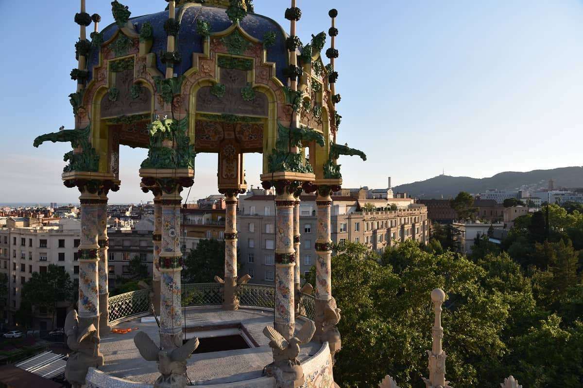
## Description **Torre Andreu**, more commonly known as **La Rotonda**, is one of Barcelona’s most distinctive yet often overlooked pieces of **Modernisme architecture**. Located at the upper edge of the city near the foothills of Tibidabo, this circular, turreted building looks more like a **fairytale castle than a residential structure**, making it one of the most visually unusual landmarks in Barcelona. The building was originally constructed in **1906** as a **luxury private residence** for a wealthy industrial family at a time when Barcelona’s elite were moving uphill away from the dense urban core. Its architectural language reflects the late phase of Catalan Modernisme, but with a lighter, more playful character than the monumental works of Gaudí. The structure’s curved form, decorative balconies, stained glass, floral stonework, and rooftop tower give it a **whimsical, almost theatrical presence**. What truly sets La Rotonda apart is its **cylindrical layout**, which is extremely rare in Barcelona’s residential architecture. While most Modernist buildings rely on flat façades and vertical symmetry, Torre Andreu embraces a soft, flowing geometry that produces constantly shifting perspectives as you walk around it. From different angles, the building seems to change character—from grand to intimate, from playful to mysterious. After serving as a private mansion, the building was later transformed into a **luxury hotel**, gaining the nickname “La Rotonda” due to its circular shape. Over the decades, it hosted visiting elites, business figures, and international guests. Its decline began in the late 20th century as the area lost its tourism focus, and the building passed through phases of limited use, abandonment, and restoration attempts. A little-known fact is that Torre Andreu spent many years in a **state of legal and architectural limbo**, with disputes over ownership and protection status delaying proper restoration. Another lesser-known detail is that its rooftops once hosted **social gatherings with views stretching across the entire city and toward the Mediterranean**, making it one of the most exclusive view points in pre-war Barcelona. Today, La Rotonda stands as a **symbol of architectural memory suspended between preservation and neglect**. While parts of the structure have undergone restoration at different times, it remains largely inaccessible to the public. Despite this, it continues to attract architects, photographers, and urban explorers who see it as a **ghost of Barcelona’s upper-class expansion era**, frozen between past luxury and uncertain future use. Emotionally, Torre Andreu is a place of contrast. It feels playful yet melancholic, elegant yet isolated. It reminds visitors that not all architectural masterpieces sit in crowded tourist centers—some survive quietly at the city’s edges, waiting to be rediscovered. ## Location **Torre Andreu (La Rotonda)** is located in the **Sant Gervasi–La Bonanova area**, near the start of **Avinguda del Tibidabo**, one of Barcelona’s most elegant upper-city avenues. **City:** Barcelona **Region:** Catalonia (Catalunya) **Country:** Spain **District:** Sarrià-Sant Gervasi **Nearby Landmark:** Plaça Kennedy ### How to Get There: * **By Tramvia Blau:** Take the historic **Blue Tram** from Plaça Kennedy up toward Tibidabo and get off at the early stops. * **By FGC (Train):** Take **FGC Line L7** to **Avinguda Tibidabo Station**, then walk about 10–12 minutes uphill. * **By bus:** Several lines from the city center serve Plaça Kennedy and Avinguda Tibidabo. * **By taxi:** A convenient option given the uphill location. * **By car:** Limited street parking is available; traffic can be heavy during peak hours. This location places La Rotonda along a scenic route that connects the city to **Tibidabo Mountain, the funicular, and the upper residential quarters**. ## Tips * **Admire it from the street:** The building is **not generally open to the public**, so plan for an exterior visit. * **Visit during daylight:** Details in stone, glass, and ironwork are best visible in strong natural light. * **Combine with Avinguda Tibidabo:** The walk itself features some of Barcelona’s most impressive mansions. * **Photography enthusiasts:** A wide-angle lens works best due to the building’s curved geometry. * **Do not expect tourist facilities:** No tickets, gift shops, or official visitor services are available on-site. * **Urban-exploration atmosphere:** The charm lies in observing a historic building existing quietly within daily city life. * **Respect private property limits:** Security patrols may restrict close access to entrances. ## Conclusion **Torre Andreu (La Rotonda)** is one of Barcelona’s most unusual Modernist buildings—**playful in form, dramatic in history, and quiet in presence**. Once a symbol of luxury living at the city’s upper edge, it now stands as a reminder that architectural brilliance does not always remain in the spotlight. For those willing to explore beyond the standard tourist circuit, La Rotonda offers a rare encounter with **Barcelona’s forgotten elegance and unresolved heritage**. ## FAQ **1. Why is Torre Andreu called “La Rotonda”?** Because of its **distinct circular shape**, which is rare in Barcelona’s residential architecture. **2. Can visitors go inside La Rotonda?** No. It is **not generally open to the public** and is viewed from the exterior only. **3. Who designed Torre Andreu?** It was designed in the early 20th century in the **Catalan Modernisme style**, attributed to architect **Adolf Ruiz i Casamitjana**. **4. Was it always a hotel?** No. It was originally built as a **private luxury residence** and later converted into a hotel. **5. Is Torre Andreu protected as a heritage site?** Yes. It is recognized as part of **Barcelona’s protected architectural heritage**, though restoration has been slow. **6. How long does a visit typically take?** About **10 to 20 minutes**, mainly for observation and photography. ## Links * [Visit Barcelona](https://www.barcelonaturisme.com)
GemVoyage Team • World
Kampala
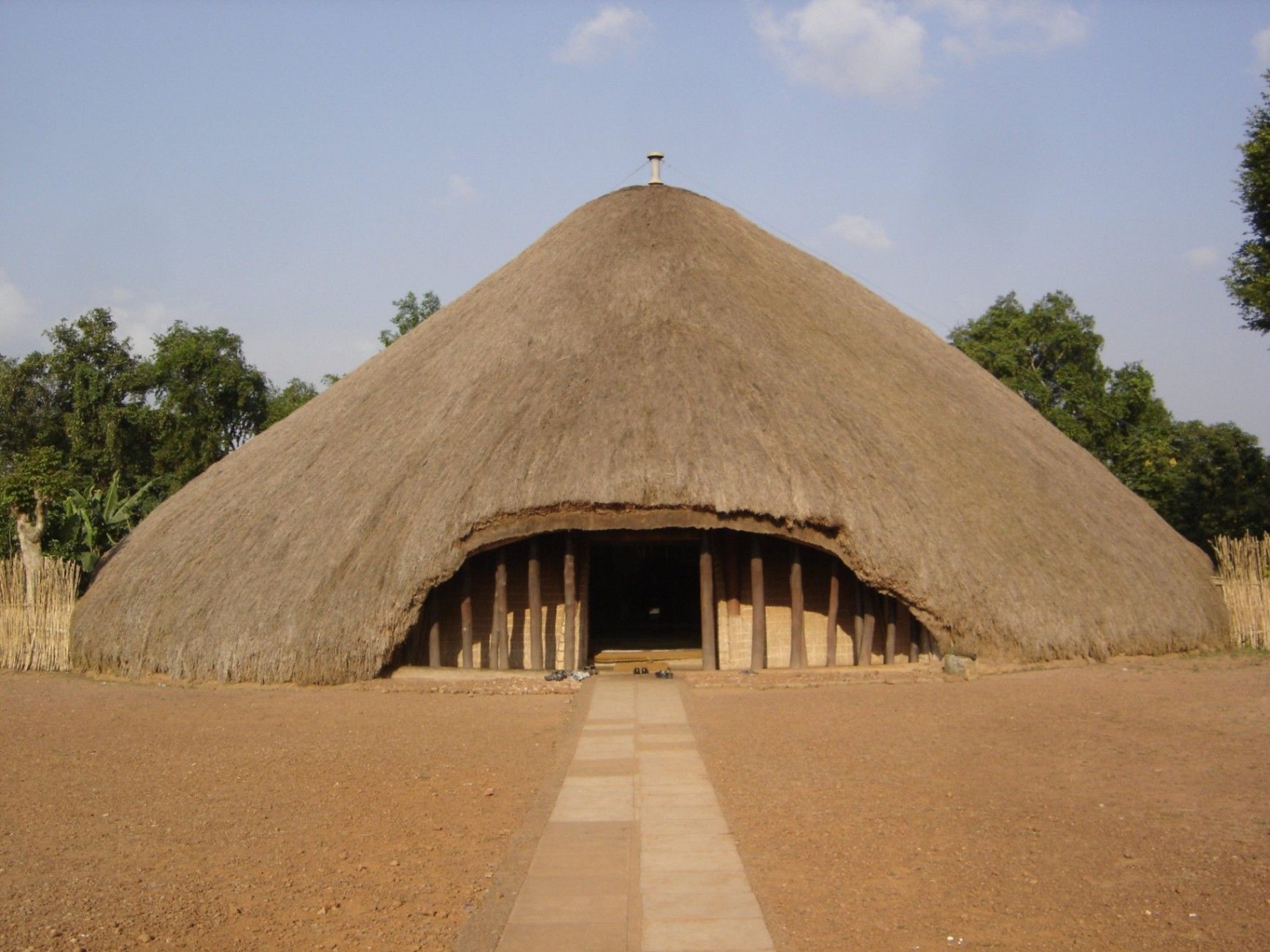
## Description The Kasubi Tombs are one of Uganda’s most important cultural and historical landmarks, serving as the burial grounds of the kings (Kabakas) of the Buganda Kingdom. Recognized as a UNESCO World Heritage Site, the Kasubi Tombs are not only a place of remembrance but also a living spiritual center where traditions, rituals, and royal customs are still actively practiced. The site reflects the deep-rooted cultural identity of the Baganda people and offers visitors a rare opportunity to experience African heritage that is both ancient and ongoing. What makes the Kasubi Tombs especially unique is their architectural style. The main structure, known as the Muzibu Azaala Mpanga, is built almost entirely from organic materials such as wood, reeds, grass, and bark cloth, showcasing remarkable traditional engineering techniques passed down through generations. A little-known fact is that the massive domed structure was once considered one of the largest thatched buildings in Africa. Another lesser-known detail is that even after a devastating fire in 2010 severely damaged the main tomb, restoration efforts were guided by traditional craftsmen using ancestral knowledge rather than modern construction methods, preserving the site’s cultural authenticity. Visiting the Kasubi Tombs is not just a historical experience; it is a deeply spiritual one that highlights the enduring connection between the Buganda monarchy, its people, and their land. ## Location The Kasubi Tombs are located in **Uganda**, in the **Central Region**, within **Kampala**, the country’s capital city. The site sits on Kasubi Hill, approximately 5 kilometers northwest of Kampala’s city center. Getting there is relatively easy. Visitors can reach the Kasubi Tombs by taxi, private car, or motorcycle taxi (boda-boda) from central Kampala. The journey usually takes 15 to 25 minutes, depending on traffic. For those unfamiliar with the area, hiring a local driver or using a guided tour is recommended, as it ensures smoother navigation and provides cultural context during the visit. ## Tips * Dress modestly and respectfully, as the site is a sacred royal burial ground. * Photography may be restricted in certain areas, especially inside the main tomb, so always ask for permission. * Consider hiring a local guide at the entrance to gain deeper insight into Buganda history and traditions. * Visit in the morning when the site is quieter and temperatures are more comfortable. * Be respectful of ongoing rituals or ceremonies, as the site is still actively used by the Buganda Kingdom. * Carry small cash for entrance fees, guides, or donations. ## Conclusion The Kasubi Tombs offer a powerful and authentic insight into Uganda’s royal history and living cultural traditions. As a sacred site and a symbol of resilience, they stand as one of Kampala’s most meaningful attractions, rewarding visitors with knowledge, reflection, and cultural understanding. ## FAQ **Why are the Kasubi Tombs important?** They are the burial place of four Buganda kings and a central spiritual site for the Buganda Kingdom. **Is the Kasubi Tombs site fully restored?** Restoration is ongoing, guided by traditional methods to maintain cultural integrity, following the 2010 fire. **How long does a visit usually take?** Most visits last between one and two hours, including a guided tour. **Is the site suitable for children?** Yes, older children can benefit from the educational and cultural aspects, though supervision is advised. **Do I need a guide to visit the Kasubi Tombs?** A guide is not mandatory but highly recommended for a fuller understanding of the site’s significance. ## Links * [UNESCO – Kasubi Tombs](https://whc.unesco.org/en/list/1022) * [Uganda Tourism Board](https://exploreuganda.com/)
GemVoyage Team • World

Dubysa
## Description Lyduvėnai Bridge is an arresting piece of nineteenth- and twentieth-century engineering that spans the deep, wooded Dubysa River valley near Lyduvėnai. Its soaring iron arches and lattice work combine functional railway engineering with a sculptural presence that is particularly striking when framed by the steep gorge below. Photographers, history enthusiasts and hikers are drawn to the site for the dramatic perspectives it creates—an industrial monument suspended over a wild, verdant canyon. Over time the bridge has required restorations and careful maintenance, and those interventions are part of its layered history. Local preservation efforts have sought to keep the bridge operational while respecting its historical materials and structure. The engineered spans and riveted ironwork tell a story about rail transport, regional development and the craft of steel construction. Beyond its technical merits, Lyduvėnai Bridge sits within a landscape of trails, viewpoints and small rural roads that allow visitors to explore the canyon from multiple angles. Birdsong and river sounds contrast with the bridge’s metallic lines, and seasonal changes—spring greens, autumn foliage—transform the setting dramatically, offering different moods for photographic study. ## Location Lyduvėnai Bridge is located near the village of Lyduvėnai in Raseiniai district municipality, Kaunas County, central-western Lithuania. It spans the Dubysa River in a steep, forested valley that is characteristic of the region’s mixed agricultural and wooded landscape. Access is most convenient by car: follow regional roads from Raseiniai and nearby towns. Public transport to the immediate vicinity is limited, so visitors relying on buses or trains should plan for a taxi or private transfer for the final leg. The rural setting rewards a slower pace—park at designated pullouts or village car parks and follow marked trails toward viewpoints. ## Tips - Photograph at golden hour—early morning or late afternoon—when light sculpts the ironwork and the valley takes on warm tones. - Never walk on active tracks; use official viewpoints and trails to keep a safe distance while still getting dramatic compositions. - Bring sturdy shoes and insect repellant for nearby trails; the area can be steep and overgrown in parts. - Combine the visit with local villages, riverside hikes and birdwatching; pack water and snacks as amenities are sparse. - Check local guidance on accessibility—some viewpoints require steep walks, while others are more level and family-friendly. ## Conclusion Lyduvėnai Bridge is an exemplar of how engineering and landscape can produce a site of compelling beauty. The bridge rewards visitors who slow down to observe structural detail, changing light and the interplay of human craft with natural settings. Whether you come for history, photography or a quiet day outdoors, the bridge and its surrounding valley offer memorable vistas and a distinct slice of regional heritage. ## FAQ Q: Can visitors walk across the bridge? A: No. For safety and legal reasons, do not walk on active railway tracks. Use the designated viewpoints and trails which provide safe vantage points. Q: Is the bridge accessible by car? A: Yes, but roads are rural and sometimes narrow—drive carefully and park only in designated areas or official pullouts. Q: Are there guided tours or information panels on site? A: Information is limited on-site; local heritage groups sometimes publish guides or online materials—check regional tourism resources for up-to-date information. Q: What wildlife might I see in the Dubysa valley? A: The valley supports woodland birds, small mammals and a range of plant life; spring and autumn are best for birdwatching and seasonal flora. Q: Is it possible to photograph the bridge from below? A: Some viewpoints near the riverside allow lower-angle shots, but access may be steep and require caution; respect private property and posted restrictions. ## Links - [Lyduvėnai Bridge](https://militaryheritagetourism.info/en/military/sites/view/800)
GemVoyage Team • World
Paris
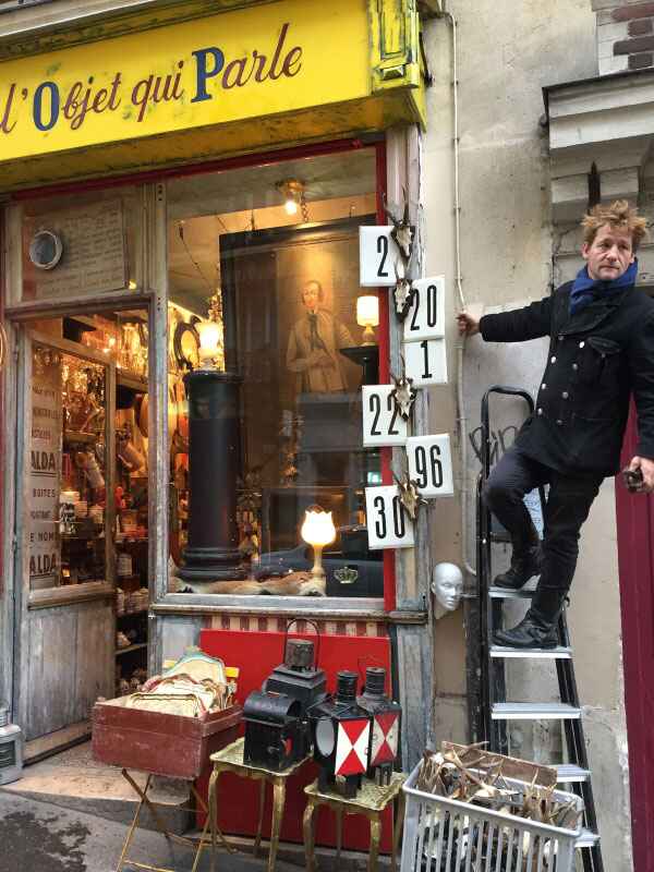
## Description Tucked away in the bohemian neighborhood of Montmartre, **L’Objet Qui Parle** is a small but legendary antique shop that has earned a reputation as one of Paris’s most fascinating hidden gems. Unlike large, glossy antique markets, this boutique offers an intimate and eclectic experience. The moment you step inside, you are greeted with an enchanting jumble of objects—stacked paintings, vintage trinkets, retro furniture, ceramics, mirrors, and curiosities that feel like they carry stories from centuries past. What makes L’Objet Qui Parle unique is its **authentic “cave of wonders” atmosphere**. The shop is famously cluttered, with items spilling from shelves and even tucked into corners, yet this controlled chaos is exactly what draws treasure hunters, collectors, and curious travelers. Each visit feels like a miniature archaeological dig, where one never knows what rare or unusual item might be unearthed. A little-known fact is that the shop has served as a source of inspiration for local artists and filmmakers, who come here seeking objects with character and history. Another interesting detail is that many items are surprisingly affordable compared to other antique shops in Paris, making it possible to find genuine vintage pieces without breaking the bank. ## Location L’Objet Qui Parle is located in **Paris, France**, within the **Île-de-France region**. More precisely, it sits in the **18th arrondissement**, right in the heart of **Montmartre**, not far from the iconic Sacré-Cœur Basilica and Place du Tertre, the artists’ square. How to get there: * **By metro:** The closest stations are **Lamarck – Caulaincourt (Line 12)** and **Abbesses (Line 12)**, both just a short walk away. * **By bus:** Several buses run through Montmartre, stopping near the shop. * **On foot:** If you’re exploring Montmartre, it’s easy to stumble upon the shop while wandering its cobbled streets. Its central location makes it perfect to combine with a day exploring Montmartre’s historic streets, cafés, and art studios. ## Tips Here are some tips to make the most of your visit to L’Objet Qui Parle: 1. **Come with an open mind** – The shop is filled with an eclectic mix of items, so be ready to browse without a fixed agenda. 2. **Take your time** – Treasures are often hidden in plain sight, stacked behind or beneath other objects. 3. **Bring cash** – While Paris is modern, some small antique shops still prefer cash for smaller purchases. 4. **Ask questions** – The shop’s owner is known for being friendly and knowledgeable, happy to share the story behind certain pieces. 5. **Visit Montmartre afterward** – Combine your stop with visits to Sacré-Cœur, local cafés, and art galleries to get the full Montmartre experience. 6. **Pack light** – The shop is quite small, so it’s best not to carry bulky bags when exploring. ## Conclusion L’Objet Qui Parle is more than just an antique shop—it’s an experience of discovery. With its cluttered charm, eclectic treasures, and Montmartre location, it offers a glimpse into the artistic and bohemian soul of Paris. Whether you’re a seasoned collector or simply curious, this little shop promises surprises and stories with every visit. ## FAQ **1. What does “L’Objet Qui Parle” mean?** It translates to “The Object That Speaks,” reflecting the idea that every antique carries a story from the past. **2. What kind of items can I find at L’Objet Qui Parle?** The shop sells a wide variety of antiques, including vintage furniture, ceramics, mirrors, paintings, religious artifacts, and quirky collectibles. **3. Is L’Objet Qui Parle expensive?** Not necessarily. While some rare pieces can be pricey, many items are surprisingly affordable, especially compared to larger Parisian antique markets. **4. How much time should I spend there?** Most visitors spend 30 minutes to an hour browsing, depending on their interest in antiques. **5. Is photography allowed inside the shop?** Policies may vary, but as a rule of thumb, always ask the shop owner before taking photos. **6. When is the best time to visit?** Mid-morning or early afternoon is ideal, as Montmartre tends to get crowded later in the day. ## Links * [Paris Official Tourism Website](https://parisjetaime.com/eng/) * [Travel Guide to Paris Markets and Antiques](https://www.france.fr)
GemVoyage Team • World
Laos
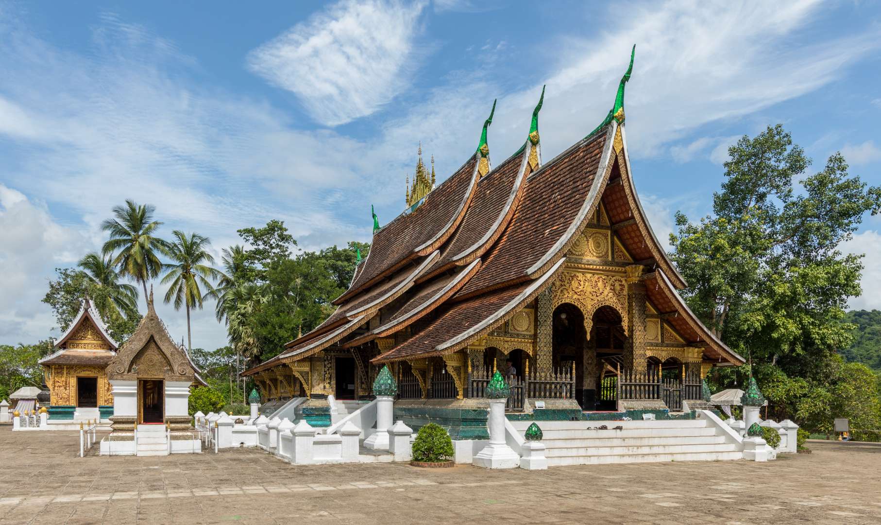
## Description Wat Xieng Thong, often referred to as the “Temple of the Golden City,” is one of the most revered and architecturally significant Buddhist temples in Laos. Located in the UNESCO World Heritage city of Luang Prabang, this 16th-century temple is a masterpiece of traditional Lao art and religious devotion. Built in 1560 by King Setthathirath, Wat Xieng Thong served as a royal temple and played a central role in religious ceremonies, coronations, and cultural festivals. The temple complex features over twenty structures, including shrines, pavilions, and monks’ quarters. Its centerpiece is the sim (main sanctuary), known for its sweeping multi-tiered roof that nearly touches the ground—a hallmark of classic Luang Prabang style. The rear façade of the sim is adorned with a stunning mosaic of the “Tree of Life,” a symbolic depiction of spiritual growth and harmony. Inside, gold stenciling on black lacquered walls illustrates scenes from Buddhist cosmology and the legendary life of King Chanthaphanith. A little-known fact: Wat Xieng Thong was spared during the sacking of Luang Prabang in 1887 by the Black Flag Haw. The invading leader, Deo Van Tri, had studied at the temple as a monk and chose to use it as his headquarters rather than destroy it. Another unique feature is the temple’s funerary carriage house, which contains an elaborate royal funeral chariot and urns used in cremation ceremonies for members of the royal family. ## Location Wat Xieng Thong is located in **Laos**, in the **Luang Prabang Province**, within the city of **Luang Prabang**. It sits at the northern tip of the peninsula formed by the Mekong and Nam Khan rivers, offering scenic views and a peaceful atmosphere. ### How to Get There - **By Foot**: If you're staying in central Luang Prabang, the temple is easily accessible by walking along the riverfront or through the old town. - **By Bicycle**: Renting a bike is a popular way to explore the city and reach Wat Xieng Thong. - **By Tuk-Tuk**: Local tuk-tuks can take you directly to the temple entrance from anywhere in town. - **By Boat**: Some river tours include a stop at the temple, offering a unique approach from the Mekong. Its location near other major attractions makes it an ideal starting point for a day of cultural exploration. ## Tips - **Visit Early or Late**: Morning and late afternoon offer softer light for photography and fewer crowds. - **Dress Modestly**: As with all religious sites in Laos, shoulders and knees should be covered. Scarves or sarongs are often available at the entrance. - **Take Your Time**: The temple complex is rich in detail. Allocate at least an hour to explore the sim, chapels, and surrounding gardens. - **Hire a Guide**: A local guide can provide deeper insights into the temple’s history, symbolism, and architecture. - **Respect the Space**: Be quiet and respectful, especially when monks are present or prayers are taking place. - **Check for Festivals**: Wat Xieng Thong hosts several annual religious events, including Pi Mai (Lao New Year), which features traditional rituals and processions. ## Conclusion Wat Xieng Thong is a cultural and spiritual gem in Luang Prabang, showcasing the elegance of Lao architecture and the depth of its Buddhist traditions. With its rich history, artistic beauty, and tranquil setting, it offers a profound and memorable experience for visitors. ## FAQ **1. What are the opening hours of Wat Xieng Thong?** The temple is open daily from 8:00 AM to 5:00 PM. **2. Is there an entrance fee?** Yes, the entrance fee is typically around 20,000 Kip per person. **3. Can non-Buddhists visit the temple?** Yes, Wat Xieng Thong is open to all visitors, regardless of religious background. **4. Is photography allowed inside the temple?** Photography is allowed in most areas, but flash and tripods are discouraged. Always be respectful. **5. Are there guided tours available?** Yes, local guides can be hired in Luang Prabang or at the temple entrance. **6. Is the temple wheelchair accessible?** Some areas may be difficult to access due to steps and uneven ground, but the main courtyard is relatively flat. ## Links - [Wat Xieng Thong – Wikipedia Overview](https://en.wikipedia.org/wiki/Wat_Xieng_Thong)
GemVoyage Team • World

Comments