GemVoyage Team • World
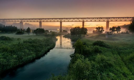
Over time the bridge has required restorations and careful maintenance, and those interventions are part of its layered history. Local preservation efforts have sought to keep the bridge operational while respecting its historical materials and structure. The engineered spans and riveted ironwork tell a story about rail transport, regional development and the craft of steel construction.
Beyond its technical merits, Lyduvėnai Bridge sits within a landscape of trails, viewpoints and small rural roads that allow visitors to explore the canyon from multiple angles. Birdsong and river sounds contrast with the bridge’s metallic lines, and seasonal changes—spring greens, autumn foliage—transform the setting dramatically, offering different moods for photographic study.
Access is most convenient by car: follow regional roads from Raseiniai and nearby towns. Public transport to the immediate vicinity is limited, so visitors relying on buses or trains should plan for a taxi or private transfer for the final leg. The rural setting rewards a slower pace—park at designated pullouts or village car parks and follow marked trails toward viewpoints.
Q: Is the bridge accessible by car?
A: Yes, but roads are rural and sometimes narrow—drive carefully and park only in designated areas or official pullouts.
Q: Are there guided tours or information panels on site?
A: Information is limited on-site; local heritage groups sometimes publish guides or online materials—check regional tourism resources for up-to-date information.
Q: What wildlife might I see in the Dubysa valley?
A: The valley supports woodland birds, small mammals and a range of plant life; spring and autumn are best for birdwatching and seasonal flora.
Q: Is it possible to photograph the bridge from below?
A: Some viewpoints near the riverside allow lower-angle shots, but access may be steep and require caution; respect private property and posted restrictions.
Discover more hidden gems you might love.
St. Petersburg
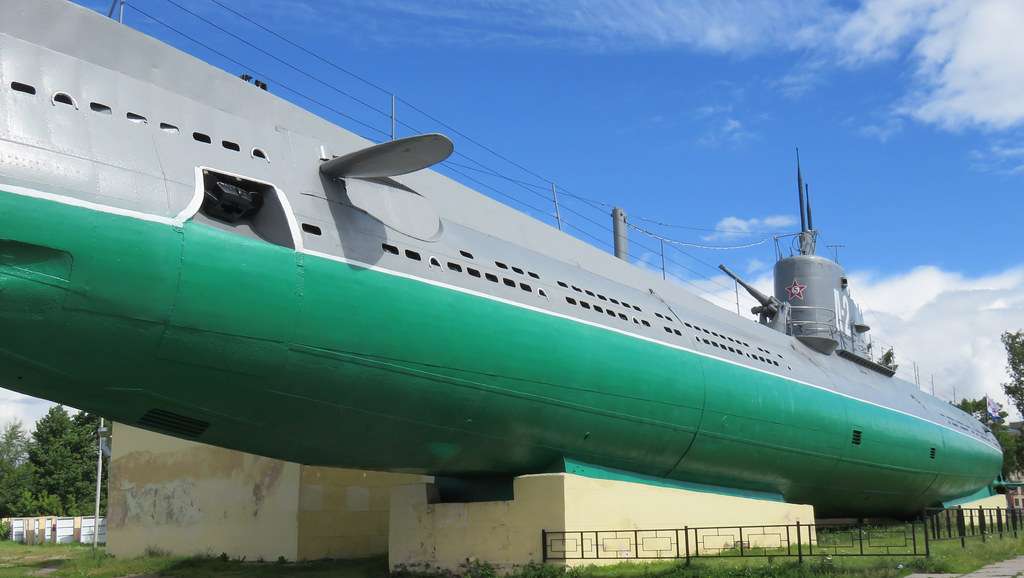
## Description The Narodovolets D-2 Submarine Museum in St. Petersburg is a compelling and immersive tribute to Russia’s naval history, offering visitors a rare opportunity to step inside a real Soviet-era submarine. Commissioned into the Baltic Fleet in 1931, the Narodovolets was one of the first submarines built by the Soviet Union and played a significant role during World War II. It completed four combat missions, launched twelve torpedo attacks, and successfully sank four enemy vessels—an impressive record for its time. Today, the submarine is mounted in concrete near the Shkiperskiy Canal and serves as a branch of the Central Naval Museum. Visitors can explore its authentic interiors, including the torpedo launcher compartment, engine room, crew quarters, and command center. The museum offers a hands-on experience of life aboard a submarine in the early 20th century, complete with original equipment and detailed exhibits. A little-known fact: the Narodovolets was named after the revolutionary sailors of the cruiser Aurora, symbolizing the spirit of Soviet naval resilience. Another fascinating detail is that the submarine was preserved and turned into a museum in 1993, making it one of the few surviving vessels of its kind open to the public. ## Location The Narodovolets Submarine Museum is located in **Russia**, in the **Northwestern Federal District**, within the **city of St. Petersburg**. It sits on **Vasilyevsky Island**, at **10 Shkiperskiy Protok**, near the waterfront and within walking distance of the Gulf of Finland. ### How to Get There - **By Metro**: The nearest station is Primorskaya (Line 3). From there, it’s a short walk or bus ride to the museum. - **By Bus or Trolleybus**: Bus numbers 7 and 151, and trolleybus number 10, stop near the museum. - **By Taxi**: Taxis and ride-share services like Yandex Go can take you directly to the entrance. - **By Car**: Parking is available nearby, but public transport is recommended due to limited space. Its location on Vasilyevsky Island makes it a great addition to a day of exploring St. Petersburg’s maritime and industrial heritage. ## Tips - **Wear Comfortable Clothing**: The submarine’s interior is narrow and includes steep ladders and tight corridors. Dress accordingly. - **Avoid Peak Hours**: Weekday mornings are generally quieter, offering a more relaxed experience. - **Bring a Flashlight**: While the museum is lit, some areas are dim and a small flashlight can help you see details more clearly. - **Check for Guided Tours**: Guided tours are available and provide valuable historical context and technical insights. - **Mind Accessibility**: The museum is not suitable for wheelchair users or those with limited mobility due to its confined spaces. - **Photography**: Photos are allowed, and there’s no extra fee for taking pictures—just be respectful of other visitors. ## Conclusion The Narodovolets Submarine Museum is a unique and historically rich attraction in St. Petersburg, offering a rare glimpse into Soviet naval warfare and life aboard a WWII-era submarine. With its authentic interiors and compelling exhibits, it’s a must-visit for history enthusiasts and curious travelers alike. ## FAQ **1. What are the opening hours of the Narodovolets Submarine Museum?** The museum is open daily from 10:00 AM to 6:00 PM, except on Mondays and Tuesdays. **2. What is the entrance fee?** Admission is RUB 350 for adults and RUB 200 for students. Photography is free. **3. Is the museum suitable for children?** Children are welcome, but supervision is recommended due to the submarine’s tight spaces and steep ladders. **4. Can I book a guided tour?** Yes, guided tours are available and can be arranged on-site or through the Central Naval Museum. **5. Is the museum wheelchair accessible?** No, the submarine’s design makes it inaccessible for wheelchair users or those with mobility impairments. **6. How long should I plan for a visit?** A typical visit lasts 45 minutes to an hour, depending on whether you join a guided tour. ## Links - [Narodovolets Submarine Museum – Saint Petersburg Guide](http://www.saint-petersburg.com/museums/narodovolets-d-2-submarine/) - [Central Naval Museum – Narodovolets Branch](https://eng.navalmuseum.ru/filials/narodovolec)
GemVoyage Team • World
Melbourne
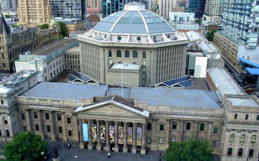
## Description State Library Victoria is more than just a library—it’s a cultural icon, architectural marvel, and a vibrant public space in the heart of Melbourne. Established in 1854, it holds the distinction of being Australia’s oldest public library and one of the first free libraries in the world. Today, it’s also one of the busiest, welcoming millions of visitors each year who come not only to read, but to explore exhibitions, attend events, and marvel at its historic interiors. The library’s crown jewel is the La Trobe Reading Room, a stunning octagonal chamber topped with a majestic domed ceiling. With its white balconies, timber desks, and natural light streaming through the dome, it’s a favorite spot for students, artists, and photographers. Beyond its beauty, the library houses over five million items, including rare manuscripts, maps, photographs, and artworks. Highlights include Ned Kelly’s original armor and the Jerilderie Letter, offering a glimpse into Australia’s bushranger folklore. A little-known fact: the library was originally envisioned as a combined museum, gallery, and library. Its founder, Sir Redmond Barry, also laid the foundation stone for the University of Melbourne on the same day as the library’s cornerstone. Another quirky detail—one of the library’s permanent exhibitions includes a collection of human hair, part of a broader exploration of Victorian-era curiosities. ## Location State Library Victoria is located in **Australia**, in the **state of Victoria**, within the city of **Melbourne**. The library sits prominently at **328 Swanston Street**, right in the Central Business District (CBD), making it easily accessible and surrounded by shops, cafés, and cultural landmarks. ### How to Get There: - **By Train**: The nearest station is Melbourne Central, just across the street. Flinders Street Station is also within walking distance. - **By Tram**: Multiple tram lines stop at the Swanston Street and La Trobe Street intersection, right outside the library. - **By Foot**: If you’re exploring the CBD, the library is a short walk from Bourke Street Mall and the State Parliament. - **By Bike**: Melbourne’s bike lanes and shared paths make cycling to the library a breeze. Bike racks are available nearby. Its central location makes it a perfect starting point for a day of cultural exploration in Melbourne. ## Tips for Visitors To make the most of your visit to State Library Victoria, keep these tips in mind: - **Join a Guided Tour**: Free tours are available and offer fascinating insights into the library’s history, architecture, and collections. - **Visit the Dome Galleries**: Located above the La Trobe Reading Room, these galleries host rotating exhibitions and provide stunning views of the dome. - **Check the Events Calendar**: From author talks to creative workshops, the library hosts a wide range of public programs. - **Use the Free Wi-Fi**: Ideal for remote work or study sessions in a beautiful setting. - **Explore the Cowen Gallery**: This gallery showcases Australian art and historical portraits, often overlooked by casual visitors. - **Respect Quiet Zones**: While the library is lively, some areas are designated for silent study—be mindful of signage. ## Conclusion State Library Victoria is a dynamic blend of history, learning, and public engagement. Whether you're diving into research, admiring its architecture, or simply relaxing in the reading room, the library offers a rich and inspiring experience in the heart of Melbourne. ## FAQ **1. Is there an entrance fee to visit State Library Victoria?** No, entry is free for all visitors. **2. What are the library’s opening hours?** Typically, Monday to Thursday: 10 AM – 9 PM; Friday to Sunday: 10 AM – 6 PM. Galleries close at 5 PM daily. **3. Can I take photos inside the library?** Yes, photography is allowed in most public areas, but flash and tripods are discouraged. **4. Is the library suitable for children?** Absolutely. There are dedicated children’s areas and family-friendly events throughout the year. **5. Are food and drinks allowed inside?** Food and drinks are not permitted in reading rooms but are allowed in designated areas. **6. Does the library offer research assistance?** Yes, librarians are available to help with research, and there are dedicated tools for family history and academic inquiries. ## Links - [State Library Victoria – Wikipedia Overview](https://en.wikipedia.org/wiki/State_Library_Victoria)
GemVoyage Team • World
Oslo
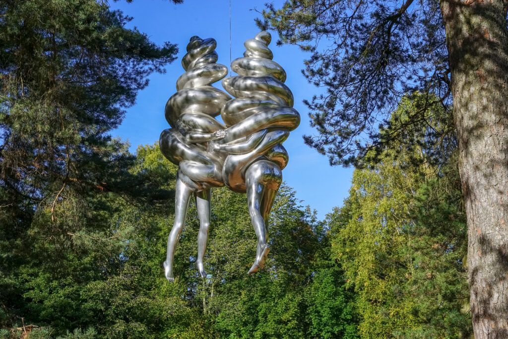
## Description Ekebergparken Sculpture Park is one of Oslo’s most rewarding places to combine contemporary art with open-air exploration. Set on a wooded hill overlooking the city and the Oslofjord, the park mixes sculpture, landscape design, and long walking paths in a setting that feels less like a formal museum and more like an expanded outdoor experience. Visitors come for the art, but many stay for the sweeping views, the quiet forest atmosphere, and the sense that each path can reveal something unexpected. The park’s appeal lies in its variety. One moment you are looking at a monumental sculpture in an open clearing, and the next you are walking through trees where smaller works appear almost discreetly within the landscape. That balance between art and nature gives the park a strong identity. It is also one of the few places in Oslo where you can experience large-scale contemporary sculpture without the pressure of indoor galleries or ticket-driven time limits. The overall effect is relaxed, but it is also carefully curated. One lesser-known aspect of Ekebergparken is that the site has long carried cultural associations beyond its current role as a sculpture park. The hill has been important in Oslo’s history and imagination for centuries, and the park’s placement takes advantage of both the geological terrain and the city views. Another interesting fact is that the park is not only about major names in sculpture; it often rewards visitors who slow down and pay attention to how each work interacts with light, weather, and seasonal changes. A piece that seems subtle in summer can feel dramatically different in winter or at dusk. ## Location Ekebergparken is located in the Ekeberg area of Oslo, Norway, on a hill east of the city center. Its elevated position makes it easy to identify on a map, and the park is accessible from central Oslo without much difficulty. The simplest way to get there is by tram or bus followed by a short uphill walk, though many visitors use taxis or ride-hailing services to save energy for the walking inside the park. If you enjoy city walks, you can also reach the area on foot from central Oslo, but be prepared for a climb. Because the park is spread out, comfortable shoes matter more than almost anything else. ## Tips Wear walking shoes and dress for changing weather, since the park is exposed and conditions can shift quickly. Allow more time than you think you need. The park is best enjoyed slowly, with room for detours and view stops. Bring a camera, but do not rush the experience. Some of the best moments happen when you simply pause at a viewpoint or sit near a sculpture. Visit near sunset if you want the city views at their most dramatic, but note that the park can feel cooler and windier later in the day. Check the park’s current sculpture map or seasonal information before going, since installations and access details can change. ## Conclusion Ekebergparken is one of Oslo’s strongest outdoor cultural experiences, combining sculpture, landscape, and city views in a single memorable walk. ## FAQ ### Is Ekebergparken free to visit? The park itself is generally open as an outdoor public experience, though specific events or facilities may have separate conditions. ### How long should I spend there? Plan at least two to three hours if you want to enjoy both the sculptures and the viewpoints. ### Is Ekebergparken suitable for families? Yes, especially for families that enjoy walking outdoors and exploring art in a relaxed setting. ### What makes the park different from a regular sculpture garden? Its natural setting, large views over Oslo, and integration of art with forest trails make it feel more immersive than a typical sculpture lawn. ### Can I visit in winter? Yes, but dress warmly and expect snowy or slippery paths depending on the season. ## Links - [Official website](https://ekebergparken.com/) - [Ekebergparken on Wikipedia](https://en.wikipedia.org/wiki/Ekebergparken_Sculpture_Park)
GemVoyage Team • World
Jeju
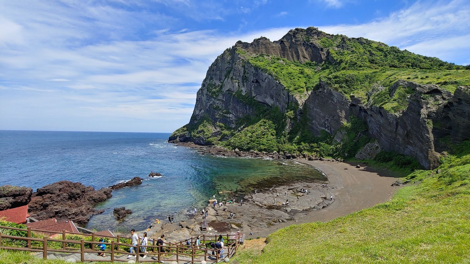
## Description Jeju Island, off South Korea’s southern coast, is a volcanic island known for Hallasan (a volcanic shield and South Korea’s highest mountain), lava tubes, basalt cliffs and distinctive stone walls. The island’s mix of beaches, rugged coastlines like Jusangjeolli, and cultural attractions (women divers known as haenyeo, folk villages and tangerine orchards) creates a varied visitor experience. Jeju’s volcanic geology also supports extensive lava tube systems (a UNESCO World Heritage feature) and scenic peaks that reward hikers and geotourists alike. Jeju’s character is both natural and cultural: haenyeo divers have shaped coastal traditions for generations, while island produce — particularly tangerines and seafood — influences local cuisine. The island’s microclimates mean you can experience contrasting conditions across short distances: misty highland mornings on Hallasan and temperate breezes on coastal beaches the same day. For outdoor enthusiasts, Jeju offers crater rims, coastal walking trails, and extensive cycling routes that reveal cliffs, hidden coves and agricultural terraces. In addition to natural features, Jeju preserves a strong vernacular culture: folk villages, stone statues (dol hareubang) and cultural festivals highlight island identity. Conservation efforts balance tourism with environmental protection, and community-based tourism initiatives allow visitors to learn about haenyeo traditions and local crafts while supporting sustainable livelihoods. ## Location Jeju Island (Jeju-do) sits about 100 km south of the Korean Peninsula and is accessible via frequent flights from Seoul, Busan and select international cities, as well as ferries from nearby ports. Jeju City and Seogwipo serve as principal hubs for exploration, with major roads connecting coastal attractions and national park trails. ## Tips - **Rent a car for flexible exploration:** Public buses cover major routes but can be slow for visiting remote sites. Renting a car gives you access to trailheads and quiet coves. - **Plan hikes on Hallasan and coastal trails in advance:** Popular trails may require permits or early starts; check trail conditions and weather before ascending. - **Try local cuisine and farm visits:** Sample Jeju black pork, fresh seafood, and citrus-based products. Farm and orchard visits offer seasonal experiences like tangerine picking. - **Respect haenyeo traditions and regulations:** Observe diving zones from designated viewpoints and book community-led experiences to learn about their craft responsibly. - **Choose quieter seasons for hiking and photography:** Spring blossom and autumn colors provide excellent conditions with fewer crowds than peak summer beach season. ## Conclusion Jeju Island blends accessible volcanic landscapes with resilient island culture, making it an ideal destination for active exploration and relaxed coastal time. Whether you favor volcanic hikes, coastal drives, cultural immersion with haenyeo communities, or sampling island cuisine, Jeju rewards travelers with variety, scenic contrasts and approachable outdoor adventures. ## FAQ - **Q: When is the best time to visit Jeju for hiking and mild weather?** A: Spring (April–June) and autumn (September–November) offer mild temperatures, clear skies and lower humidity — ideal for hiking and outdoor photography. - **Q: Are the lava tubes and Hallasan summit accessible to casual visitors?** A: Many lava tube sections are set up with visitor facilities and guided tours; Hallasan hikes range from short trails to challenging summit routes that require good fitness and early starts. - **Q: Is it easy to get around Jeju without a car?** A: Public buses cover major routes but can be slow for visiting remote sites. Renting a car is the most convenient option for flexible itineraries. - **Q: What cultural experiences should I prioritize?** A: Visit a haenyeo cultural center, explore folk villages, try local markets and attend seasonal festivals for authentic cultural encounters. - **Q: How family-friendly is Jeju?** A: Very — many sites are suitable for families, with beaches, theme attractions and short nature walks; always plan for sun protection and weather variability. ## Links - [Jeju Island — Wikipedia](https://en.wikipedia.org/wiki/Jeju_Island)
GemVoyage Team • World
Milan
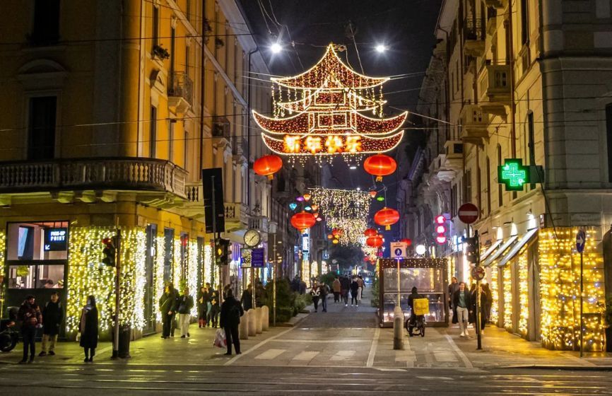
## Description **Chinatown in Milan (Quartiere Cinese di Milano)** is a lively, colorful district that blends **Italian sophistication with Chinese tradition**, creating one of the most vibrant cultural areas in northern Italy. Established in the early 20th century, it is the **oldest and largest Chinatown in Italy**, and today it thrives as a bustling hub of food, culture, and community life. The neighborhood is centered around **Via Paolo Sarpi**, a pedestrian-friendly street lined with Asian grocery stores, authentic restaurants, tea shops, and modern fashion boutiques. Red lanterns and bilingual signs decorate the streets, while the aroma of dumplings, noodles, and roasted duck fills the air. It’s a place where tradition meets innovation — where family-run Chinese bakeries coexist with trendy Milanese cafés and design studios. What makes Milan’s Chinatown unique is how seamlessly it integrates into the city’s cosmopolitan identity. Beyond being a culinary destination, it’s also a **center for art, trade, and cross-cultural exchange**. The area has become increasingly popular among young professionals and artists who appreciate its multicultural atmosphere and creative energy. A little-known fact is that Chinatown in Milan began as a **settlement of Chinese workers from Zhejiang province** in the 1920s, who came to Italy to work in the textile and leather industries. Over time, they established businesses that became essential to Milan’s fashion scene — a legacy that still endures today. Another fascinating detail: every year, the neighborhood hosts an elaborate **Chinese New Year parade**, drawing thousands of locals and tourists to celebrate with dragon dances, fireworks, and street performances. ## Location Milan’s Chinatown is located in the **northwestern part of the city center**, primarily along **Via Paolo Sarpi** in the **Porta Volta area**, **Lombardy region**, **Italy**. To get there: * **By metro:** Take **Line 2 (Green Line)** to **Moscova Station** or **Line 5 (Purple Line)** to **Monumentale Station**. Both are a short walk from Via Paolo Sarpi. * **By tram:** Tram lines **12 and 14** stop nearby. * **By foot:** It’s about a **15–20 minute walk** from the Duomo or Brera district, making it an easy stop during a city stroll. The area is pedestrian-friendly, making it perfect for exploring on foot while sampling food or browsing local shops. ## Tips * **Come hungry:** Chinatown is one of the best places in Milan for authentic Chinese, Vietnamese, and Thai cuisine. Popular dishes include **dim sum, baozi (steamed buns),** and **hand-pulled noodles**. * **Visit during Chinese New Year:** The celebrations are among the largest in Italy, featuring parades, performances, and cultural exhibits. * **Explore side streets:** Don’t just stay on Via Paolo Sarpi — nearby lanes hide charming bakeries, tea shops, and Asian supermarkets. * **Try local fusion spots:** Milan’s creativity shines through in restaurants that blend Asian and Italian flavors, reflecting the district’s evolving culinary scene. * **Shop for Asian ingredients:** Supermarkets like **Kathay** are famous for offering rare spices, sauces, and produce that are hard to find elsewhere in Italy. * **Visit in the evening:** As the lights come on, the red lanterns and street buzz create a magical, cinematic atmosphere. ## Conclusion **Chinatown in Milan** is far more than a neighborhood — it’s a living story of migration, adaptation, and community. From its early days as a textile hub to its present status as a vibrant cultural destination, it reflects Milan’s openness and diversity. Whether you’re tasting authentic dim sum, shopping for exotic ingredients, or celebrating Chinese New Year, Chinatown offers a sensory journey through the heart of modern multicultural Milan. ## FAQ **1. When was Chinatown in Milan established?** It was founded in the **1920s** by Chinese immigrants, mainly from Zhejiang province, who came to work in textile and leather industries. **2. Where exactly is it located?** It centers around **Via Paolo Sarpi**, in the **Porta Volta area** of **Milan**, **Lombardy, Italy**. **3. What can I do there?** You can explore Asian shops, enjoy authentic Chinese cuisine, visit tea houses, and attend cultural festivals such as Chinese New Year. **4. Is it safe to visit Chinatown at night?** Yes, it’s considered safe and lively, with many restaurants and bars open until late. **5. What’s the best time to visit?** Any time of year is great, but **January or February** during the **Chinese New Year** offers the most festive experience. **6. Are there Italian-Chinese fusion restaurants?** Yes, several trendy eateries combine Asian flavors with Italian ingredients, reflecting the creative spirit of Milan’s dining scene. ## Links * [Official Milano Tourism Portal](https://www.yesmilano.it)
GemVoyage Team • World
Paris
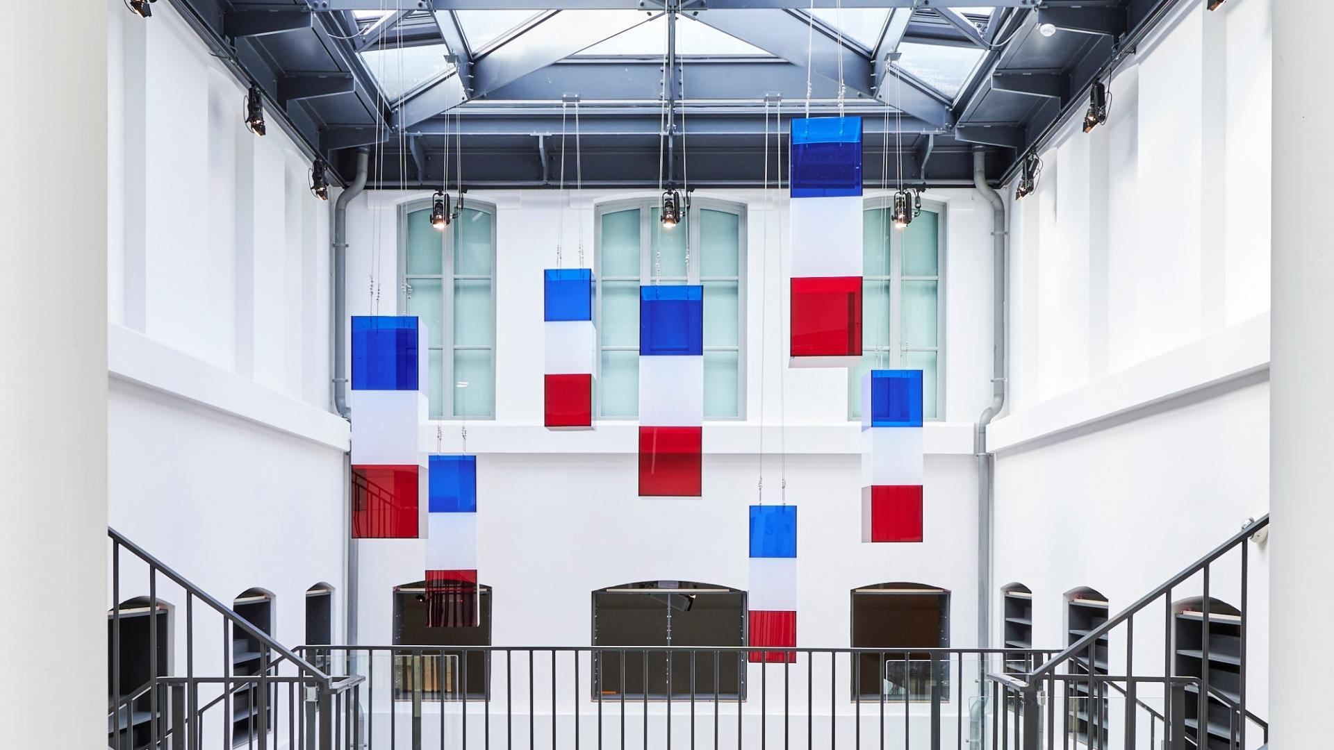
## Description **The Liberation of Paris Museum (Musée de la Libération de Paris – Musée du Général Leclerc – Musée Jean Moulin)** is one of the most important modern history museums in the French capital. Dedicated to the **German occupation of Paris (1940–1944)**, the **French Resistance**, and the **Liberation of Paris**, the museum offers a clear, unsentimental account of how the city endured, resisted, and ultimately reclaimed its freedom during World War II. What distinguishes this museum is its **focus on individuals rather than abstract events**. Through personal letters, photographs, uniforms, clandestine newspapers, and everyday objects, the museum tells the story of ordinary Parisians alongside key historical figures such as **Jean Moulin**, a central figure of the French Resistance, and **General Philippe Leclerc**, commander of the Free French forces that entered Paris in August 1944. The narrative is chronological and grounded, avoiding glorification while emphasizing moral courage and civil resistance. One of the museum’s most striking features is the preserved **underground command bunker** used by Colonel Henri Rol-Tanguy during the final days of the liberation. Visitors can descend into this space, which remains intact, offering a rare and visceral sense of wartime decision-making under pressure. A lesser-known fact is that this bunker was rediscovered relatively late and restored as part of the museum’s redesign. Another notable detail is that the museum relocated in 2019 to its current site to better reflect the historical geography of the liberation events. The museum is immersive without being overwhelming. It balances historical rigor with accessibility, making complex political and military developments understandable without diluting their seriousness. ## Location **Country:** France **Region:** Île-de-France **City:** Paris **Arrondissement:** 14th arrondissement The museum is located on **Place Denfert-Rochereau**, a historically symbolic site connected to resistance activity and wartime infrastructure. ### How to Get There * **By metro:** * Lines 4 and 6 to **Denfert-Rochereau** station. * **By RER:** * RER B stops at Denfert-Rochereau, providing direct access from airports and suburbs. * **By bus:** * Several bus lines stop directly at the square. * **On foot:** * Easily reachable from Montparnasse and surrounding neighborhoods. ## Tips * **Allow sufficient time:** Plan **1.5 to 2 hours** to fully absorb the exhibitions. * **Do not skip the bunker:** Access is limited in capacity but is a core part of the experience. * **Read the personal testimonies:** These provide emotional depth beyond dates and events. * **Visit before or after nearby sites:** The Paris Catacombs and Montparnasse Cemetery are close by. * **Suitable for older children and adults:** Some content may be intense for very young visitors. * **Free entry:** Take advantage of the museum’s permanent free access. ## Conclusion The Liberation of Paris Museum offers a sober, powerful exploration of one of the city’s defining moments. Through personal stories, preserved spaces, and clear historical context, it transforms the liberation of Paris from a symbolic event into a deeply human experience. ## FAQ **1. Is the museum free to visit?** Yes, permanent exhibitions are free for all visitors. **2. How long does the visit take?** Approximately **90 minutes to 2 hours**, depending on interest level. **3. Is the underground bunker accessible?** Yes, but access may be limited at busy times due to space constraints. **4. Is the museum suitable for non-French speakers?** Yes. Exhibits are well-labeled, and much of the content is available in multiple languages. **5. Does the museum focus only on Paris?** Primarily, but it also addresses broader resistance networks and Free French operations. **6. Is photography allowed?** Photography is generally permitted, but flash and tripods may be restricted. ## Links * [City of Paris museums portal](https://www.paris.fr) * [Official Museum Website](https://www.museeliberation-leclerc-moulin.paris.fr/en)
GemVoyage Team • World

Comments