GemVoyage Team • World
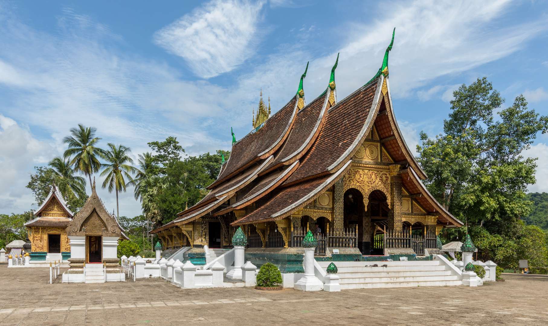
Wat Xieng Thong, often referred to as the “Temple of the Golden City,” is one of the most revered and architecturally significant Buddhist temples in Laos. Located in the UNESCO World Heritage city of Luang Prabang, this 16th-century temple is a masterpiece of traditional Lao art and religious devotion. Built in 1560 by King Setthathirath, Wat Xieng Thong served as a royal temple and played a central role in religious ceremonies, coronations, and cultural festivals.
The temple complex features over twenty structures, including shrines, pavilions, and monks’ quarters. Its centerpiece is the sim (main sanctuary), known for its sweeping multi-tiered roof that nearly touches the ground—a hallmark of classic Luang Prabang style. The rear façade of the sim is adorned with a stunning mosaic of the “Tree of Life,” a symbolic depiction of spiritual growth and harmony. Inside, gold stenciling on black lacquered walls illustrates scenes from Buddhist cosmology and the legendary life of King Chanthaphanith.
A little-known fact: Wat Xieng Thong was spared during the sacking of Luang Prabang in 1887 by the Black Flag Haw. The invading leader, Deo Van Tri, had studied at the temple as a monk and chose to use it as his headquarters rather than destroy it. Another unique feature is the temple’s funerary carriage house, which contains an elaborate royal funeral chariot and urns used in cremation ceremonies for members of the royal family.
Wat Xieng Thong is located in Laos, in the Luang Prabang Province, within the city of Luang Prabang. It sits at the northern tip of the peninsula formed by the Mekong and Nam Khan rivers, offering scenic views and a peaceful atmosphere.
Its location near other major attractions makes it an ideal starting point for a day of cultural exploration.
Wat Xieng Thong is a cultural and spiritual gem in Luang Prabang, showcasing the elegance of Lao architecture and the depth of its Buddhist traditions. With its rich history, artistic beauty, and tranquil setting, it offers a profound and memorable experience for visitors.
1. What are the opening hours of Wat Xieng Thong?
The temple is open daily from 8:00 AM to 5:00 PM.
2. Is there an entrance fee?
Yes, the entrance fee is typically around 20,000 Kip per person.
3. Can non-Buddhists visit the temple?
Yes, Wat Xieng Thong is open to all visitors, regardless of religious background.
4. Is photography allowed inside the temple?
Photography is allowed in most areas, but flash and tripods are discouraged. Always be respectful.
5. Are there guided tours available?
Yes, local guides can be hired in Luang Prabang or at the temple entrance.
6. Is the temple wheelchair accessible?
Some areas may be difficult to access due to steps and uneven ground, but the main courtyard is relatively flat.
Discover more hidden gems you might love.
Seattle
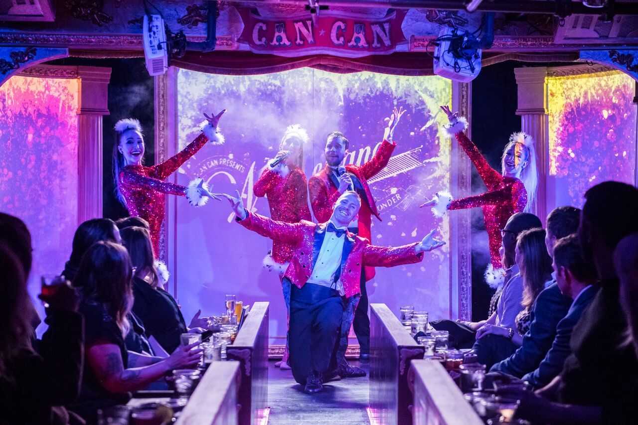
## Description Can Can Culinary Cabaret is a celebrated dinner theatre nestled inside Seattle's historic Pike Place Market. Founded in 2005 by artistic director Chris Pink and choreographer Fae Pink, the venue has produced nearly 7,000 shows over two decades, evolving from a small cabaret hosting traveling acts into one of the Pacific Northwest's most distinctive entertainment destinations. The experience blends multi-course French-inspired Northwest dining with original theatrical productions that incorporate dance, live music, burlesque, acrobatics, comedy, and multimedia elements. The intimate 120-seat theatre, evocative of turn-of-the-century Paris with its red velvet and lush booth seating, ensures every guest feels immersed in the performance. Shows run Thursday through Sunday with approximately ten performances weekly, and the creative team refreshes the entire production — including scenic design, choreography, costuming, and original music — several times each year. A defining feature is Can Can's themed seasonal shows, where the menu is carefully paired with the performance narrative, creating unique culinary-theatrical hybrids that cannot be found anywhere else in Seattle. Recent productions include a Dolly Parton tribute, the acrobatic Carnival of Curiosities, and the return of LOLA, each transforming the venue with entirely new sets and choreography. The result is a full-sensory evening where world-class entertainment and thoughtfully plated cuisine are woven into a single, unforgettable experience. ## Location Can Can Culinary Cabaret is located at 95 Pine Street, Seattle, WA 98101, inside the iconic Pike Place Market — one of the oldest continuously operated public farmers' markets in the United States, drawing over ten million visitors annually. The venue sits in the heart of downtown Seattle, just steps from the waterfront and Post Alley, with The Dressing Room bistro offering outdoor patio seating overlooking the Puget Sound. Getting there is straightforward via multiple modes of transportation. The nearest light rail stop is Westlake Station, approximately a ten-minute walk east along Pike Street. Several bus routes serve the area, including King County Metro lines stopping at Pike Street and 1st Avenue. For drivers, parking garages are available at the Pike Place Market public lot and nearby commercial garages on Western Avenue and Union Street, though availability tightens significantly on summer weekends and during peak tourist season — arriving 30 to 45 minutes early is strongly advised. Rideshare drop-offs are seamless at the Pine Street entrance. The theatre operates Thursday through Sunday from 5:00 PM to close, with specific showtimes varying by production. The Dressing Room bistro offers additional brunch hours independently of the main stage schedule and is open for walk-in dining even on non-show days. ## Tips - **Book well in advance**: Can Can productions frequently sell out, especially weekend shows and seasonal specials. Purchase tickets and pre-select your dining package early, particularly if you want VIP seating, which receives first priority for the best table placement in the intimate theatre. - **Understand the ticket tiers**: Seating is assigned by guest services based on your ticket tier. VIP receives first priority, Preferred second, and Standard third with more value-forward pricing. Groups of 10 or more must purchase VIP or Preferred tickets to sit together, and parties of 20 or more are considered partial buyouts requiring additional arrangements. - **Arrive 30 to 45 minutes early**: This allows time to check in, order pre-show cocktails at The Dressing Room, and settle into your seat before the lights dim. The show runs three acts with two intermissions, so early arrival ensures you place your food order before the performance begins and nothing interrupts the flow. - **Dress smart-casual**: There is no strict dress code, but many guests embrace the theatrical spirit with cocktail attire or polished evening wear. Avoid heavy fragrances, as the intimate space amplifies scents and some guests find this distracting during dining. - **Check age restrictions**: Most shows are adult-oriented and some are strictly 21+. Always verify age requirements when booking, especially if planning a group outing or celebrating a birthday. - **Dietary accommodations**: The kitchen accommodates vegetarian and gluten-free preferences. Notify guest services of any allergies or restrictions at the time of booking so alternatives can be prepared in advance — last-minute substitutions during the show are limited. - **Budget for gratuities and billing**: A 20% service charge is automatically added to pre-purchased food packages and parties of six or more. A 5% living-wage surcharge applies to all checks. The theatre enforces a no-split-check policy to streamline service, so plan to consolidate payment within your group. - **Tip the performers**: After the final curtain, guests are invited to mingle with and tip the cast directly — a beloved tradition that supports the artists who make the show possible. ## Conclusion Can Can Culinary Cabaret stands as a singular gem in Seattle's vibrant entertainment landscape — a place where theatrical ambition and culinary craft converge with remarkable results. Whether you are celebrating a milestone anniversary, planning an unforgettable date night, or simply seeking a night out that defies the ordinary, the venue delivers an experience that lingers long after the final curtain. With an entirely new season of productions unveiled each year, there is always a fresh reason to return. The combination of original music, world-class performance, French-inspired cuisine, and an atmosphere steeped in vintage glamour makes it one of the most distinctive things to do in Seattle. Book your tickets, arrive hungry for both food and spectacle, and discover why Can Can has remained a beloved institution for nearly twenty years. ## FAQ - **How long does a typical show last?** Expect the full experience to run 2 to 3 hours, comprising three acts and two intermissions. Dining is served tableside throughout the performance so that no moment of the show is missed. - **Is there a dress code?** There is no enforced dress code, but smart-casual or cocktail attire is recommended to match the theatrical atmosphere. Many guests treat it as a special-occasion event and dress accordingly. - **Can I dine without seeing the show?** Yes — The Dressing Room, Can Can's bistro and bar, operates independently of the theatre and offers French-inspired Northwest fare, craft cocktails, and patio seating with Puget Sound views. Reservations are recommended. - **What if I have dietary restrictions?** Vegetarian and gluten-free options are available. Inform guest services at the time of booking so the kitchen can accommodate your needs without disruption during the performance. - **Is the show appropriate for children?** Most productions are adult-oriented and may contain mature themes, suggestive humor, and burlesque elements. Check individual event listings for age recommendations before purchasing tickets for younger guests. - **Can I buy a gift certificate?** Yes — digital gift cards are available through the Can Can website and make excellent presents for birthdays, anniversaries, or holiday gifts. - **What is the cancellation and refund policy?** All sales are final. There are no refunds or exchanges, so review your order carefully before completing your transaction. - **Is there a Portland location?** Yes — Can Can operates a second venue in Portland, Oregon, at 6 SW 3rd Avenue, offering a similar dinner-and-show experience in the Pacific Northwest. ## Links - [Can Can Culinary Cabaret — Official Website](https://www.cancanseattle.com) - [Visit Seattle — Official Tourism Guide](https://www.visitseattle.org)
GemVoyage Team • World
Athens
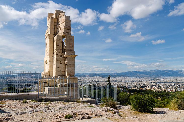
## Description Philopappos Hill is a quietly rewarding spot in Athens that combines green space, archaeological interest, and some of the city's best vantage points. Unlike the intensely visited Acropolis itself, Philopappos offers room to breathe: shaded paths, open lawns, and a prominent memorial monument that speaks to the city's Roman-era history. The hill is prized by locals and visitors looking for views, quiet reflection, and an approachable dose of history. Historically, the hill houses the Philopappos Monument, dedicated to Gaius Julius Antiochus Philopappos, a prominent figure in the Roman civic life of Athens. The site also preserves traces of long-term human use and offers a series of viewpoints that reveal the Acropolis from varied angles—useful for appreciating Athens' layered topography. The combination of nature and archaeology makes Philopappos ideal for a walk that complements more intense museum and monument visits. ## Location Philopappos Hill lies just southwest of the Acropolis in central Athens, within easy walking distance of the historic center. The hill's centrality means it can be folded into a broader exploration of the city's archaeological zones, museums, and neighborhoods such as Plaka and Thissio. Pathways connect the hill with other scenic spots, making it a natural link in a pedestrian-friendly sightseeing loop. Because some paths rise more steeply than others, sensible footwear and a modest level of mobility are helpful. The hill's proximity to major sites makes it an ideal stop for early morning or late afternoon visits when both light and temperature are more comfortable. ## Tips - Bring water, especially in summer—Athens' heat can make walks more strenuous. - Wear shoes with good grip for uneven or rocky paths. - Visit at sunrise or sunset for the best light and cooler temperatures. - Combine the hill with visits to the Acropolis, the Ancient Agora, and the neighborhoods of Plaka and Thissio. - Allow time to sit and take in the views rather than rushing through the paths. - Keep to marked routes and respect any archaeological conservation notices. ## Conclusion Philopappos Hill is an excellent complement to Athens' major monuments: quieter, greener, and full of viewpoints that help you see the Acropolis in context. It rewards visitors who seek slower sightseeing and panoramic perspectives. ## FAQ ### Why should I visit Philopappos Hill? Visit for quieter views of the Acropolis, a taste of Athenian green space, and the Philopappos Monument's historical resonance. ### How long does it take to explore? One to two hours is typical for a relaxed visit; longer if you plan to picnic or linger at viewpoints. ### Is it suitable for families? Yes—families who are comfortable with walking and light uphill sections will find it pleasant, though very young children may need supervision on uneven paths. ### Can I see the Acropolis from there? Yes—multiple viewpoints on the hill provide varied and informative perspectives of the Acropolis and surrounding city. ### Do I need a guide? Not strictly. The hill is easy to explore independently, though a guide can enrich the experience with historical context. ## Links - [Wikipedia](https://en.wikipedia.org/wiki/Philopappos_Monument)
GemVoyage Team • World
Minneapolis
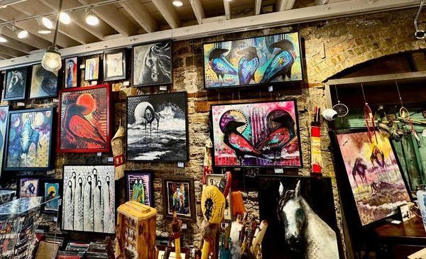
## Description Northland Visions is a well-known Native American shop in Minneapolis that celebrates Indigenous art, culture, and craftsmanship from across North America. More than just a retail space, the shop functions as a cultural bridge, offering visitors a meaningful opportunity to engage with Native traditions through authentic, ethically sourced items. The store features a wide range of products, including traditional and contemporary jewelry, beadwork, carvings, pottery, clothing, books, and ceremonial objects. What makes Northland Visions unique is its strong commitment to authenticity and Native representation. The shop works directly with Native American artists and communities, ensuring that the items sold are genuine and that artists are fairly compensated. A lesser-known fact is that Northland Visions has long been connected to the local Native community in Minnesota, particularly the Dakota and Ojibwe nations, making it an important cultural space as well as a business. Another interesting detail is that the shop often carries items connected to seasonal ceremonies and powwow culture, reflecting living traditions rather than static displays. For visitors interested in Indigenous culture, Northland Visions offers an experience rooted in respect, education, and cultural continuity. ## Location Northland Visions is located in the **United States**, in the state of **Minnesota**, within the city of **Minneapolis**. The shop is situated in the Powderhorn area of South Minneapolis, a neighborhood known for its strong community identity and cultural diversity. Visitors can reach the shop by car, public bus, or bicycle. Several Metro Transit bus routes serve the surrounding area, making it accessible from downtown Minneapolis and other neighborhoods. For those driving, street parking is generally available nearby. Using a navigation app is recommended for first-time visitors, as the shop is located in a primarily residential and commercial mixed-use area. ## Tips * Take time to ask staff about the origins and meanings of the items, as they are often happy to share cultural context. * If you are purchasing jewelry or artwork, inquire about the artist to better understand the piece’s background. * Be respectful when viewing or asking about ceremonial items, as some objects may have cultural restrictions. * Bring cash or a card, as most major payment methods are accepted. * Combine your visit with nearby local cafés or parks to explore more of South Minneapolis. * Check opening hours in advance, as they may vary seasonally or during cultural events. ## Conclusion Northland Visions offers a thoughtful and authentic introduction to Native American art and culture in Minneapolis. Through its carefully curated selection and strong community ties, the shop provides visitors with both meaningful purchases and a deeper cultural understanding. ## FAQ **Are the items at Northland Visions authentic?** Yes, the shop emphasizes genuine, Native-made products and works directly with Indigenous artists and communities. **Can I learn about the cultural significance of the items?** Yes, staff members are knowledgeable and often share information about the history and meaning behind many products. **Is Northland Visions suitable for tourists?** Absolutely. Visitors are welcome and often find the shop educational as well as culturally enriching. **Does the shop sell gifts and souvenirs?** Yes, it offers a wide range of items suitable for meaningful gifts, from small crafts to fine art pieces. **Is the shop accessible by public transportation?** Yes, multiple bus routes serve the area, making it accessible without a car. ## Links * [Northland Visions Official Website](https://www.northlandvisions.com) * [Explore Minneapolis](https://www.minneapolis.org)
GemVoyage Team • World
Barcelona
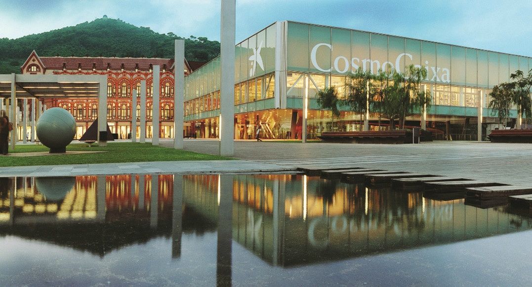
## Description The CosmoCaixa Museum of Science, officially known as Museu de la Ciència CosmoCaixa, is one of Barcelona’s most engaging and educational cultural attractions. Designed to make science accessible, interactive, and enjoyable, the museum invites visitors of all ages to explore the natural world, physics, biology, and the universe through hands-on exhibits and immersive environments. It is widely regarded as one of the best science museums in Europe. What makes CosmoCaixa unique is its emphasis on learning through experience rather than observation alone. The museum’s permanent exhibition spaces encourage visitors to touch, experiment, and question scientific principles. One of its most iconic features is the Flooded Forest, a large-scale recreation of an Amazon rainforest ecosystem complete with live plants, fish, and animals, offering an immersive look into tropical biodiversity. A lesser-known fact is that the museum building incorporates a dramatic architectural ramp system designed to guide visitors gradually through different levels of scientific exploration. Another interesting detail is that CosmoCaixa frequently updates its temporary exhibitions to reflect current scientific research and global challenges. CosmoCaixa successfully combines modern museology, cutting-edge science communication, and striking architecture, making it a standout destination in Barcelona beyond the city’s more traditional art and history museums. ## Location CosmoCaixa is located in **Spain**, in the autonomous community of **Catalonia**, within the city of **Barcelona**. It sits in the Sant Gervasi–La Bonanova district, slightly northwest of the city center, in a quieter residential area. The museum is easily reached by public transport. Visitors can take the Ferrocarrils de la Generalitat de Catalunya (FGC) train to **Avinguda Tibidabo** or **El Putxet** stations, followed by a short walk. Several bus lines also stop nearby. For those traveling by car, parking facilities are available on-site, though public transport is generally the most convenient option. ## Tips * Allow at least two to three hours to explore the museum comfortably. * Visit on weekdays or early in the morning to avoid crowds, especially during school holidays. * Don’t miss the Flooded Forest and the Planetarium, which are highlights of the museum. * Check the schedule for temporary exhibitions, workshops, and guided activities. * The museum is very family-friendly, with many exhibits designed for children and teenagers. * Take advantage of the on-site café and outdoor areas for a break during your visit. ## Conclusion CosmoCaixa Barcelona offers an engaging and thoughtful approach to science education through interactive exhibits and immersive environments. It is an ideal destination for families, students, and anyone curious about how the world works, providing a refreshing perspective on science in an accessible and enjoyable format. ## FAQ **Is CosmoCaixa suitable for children?** Yes, the museum is designed for all ages and includes many interactive exhibits for children. **How much time should I plan for a visit?** Most visitors spend between two and four hours exploring the museum. **Is there an entrance fee?** Yes, CosmoCaixa charges a modest entrance fee, with discounts for students, seniors, and families. **Are exhibits available in multiple languages?** Yes, most exhibits and information panels are available in Catalan, Spanish, and English. **Is the museum accessible for people with limited mobility?** Yes, the museum is fully accessible, with ramps, elevators, and adapted facilities. ## Links * [CosmoCaixa Official Website](https://cosmocaixa.org/es/cosmocaixa-barcelona)
GemVoyage Team • World
Porto
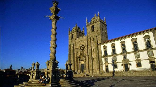
## Description Porto Cathedral, known locally as **Sé do Porto**, is one of the most iconic and historically significant landmarks in northern Portugal. Perched atop a hill in the heart of Porto’s old town, the cathedral dominates the city skyline with its fortress-like façade and commanding views over the Douro River. Construction began in the early 12th century, making it one of the oldest monuments in Porto and a cornerstone of the city’s religious and architectural heritage. The cathedral is a fascinating blend of **Romanesque, Gothic, and Baroque** styles, reflecting centuries of architectural evolution. Its original Romanesque structure is still visible in the heavy granite walls and narrow nave, while later Gothic additions include the elegant cloister and the funerary chapel of João Gordo, a Knight Hospitaller. In the 18th century, Italian architect Nicolau Nasoni added Baroque flourishes, including a grand loggia and ornate altarpieces. A little-known fact: Porto Cathedral was the site of the royal wedding between **King John I of Portugal and Philippa of Lancaster** in 1387, a union that sealed the Anglo-Portuguese Alliance—one of the oldest diplomatic alliances in the world. Another hidden gem is the **Camino de Santiago pilgrim’s credential office**, tucked discreetly beside the cathedral, where modern-day pilgrims begin their journey to Santiago de Compostela. ## Location Porto Cathedral is located in **Portugal**, within the **Norte Region**, in the city of **Porto**. It sits in the **Sé neighborhood**, one of the oldest quarters of the city, surrounded by winding cobbled streets and historic buildings. ### How to Get There: - **By Metro**: The nearest station is São Bento, just a short uphill walk from the cathedral. - **By Foot**: If you're exploring central Porto, the cathedral is easily accessible from landmarks like the Ribeira, Clérigos Tower, and Dom Luís I Bridge. - **By Taxi or Ride-Hailing**: Services like Bolt or Uber can drop you off at Terreiro da Sé, the square in front of the cathedral. Its elevated position makes it a perfect starting point for exploring Porto’s historic center. ## Tips for Visitors To make the most of your visit to Porto Cathedral, keep these tips in mind: - **Visit Early or Late**: The cathedral can get crowded during peak hours. Early morning or late afternoon visits offer a quieter experience and better lighting for photos. - **Explore the Cloister**: Don’t miss the Gothic cloister, adorned with beautiful azulejos (blue tiles) depicting religious scenes. - **Climb for Views**: The cathedral’s terrace offers panoramic views of Porto’s rooftops and the Douro River—perfect for photography. - **Combine with Nearby Attractions**: Pair your visit with São Bento Station, Palácio da Bolsa, or a walk down to the Ribeira district. - **Check for Mass Times**: If you’re interested in attending a service, check the schedule in advance. Visitors are welcome but should be respectful during religious ceremonies. - **Bring Comfortable Shoes**: The surrounding streets are steep and cobbled—wearing sturdy footwear is a must. ## Conclusion Porto Cathedral is a majestic fusion of history, architecture, and spirituality. With its commanding presence, rich artistic details, and deep cultural significance, it offers visitors a profound glimpse into the soul of Porto. Whether you're a history buff, architecture lover, or spiritual seeker, the Sé do Porto is a must-see. ## FAQ **1. What are the opening hours of Porto Cathedral?** Typically, the cathedral is open from 9:00 AM to 6:30 PM. Hours may vary on holidays and Sundays. **2. Is there an entrance fee?** Entry to the main cathedral is free. A small fee may apply to access the cloister and museum. **3. Can I take photos inside the cathedral?** Yes, photography is allowed, but flash should be avoided, especially during services. **4. Is Porto Cathedral accessible for people with mobility issues?** The main entrance is accessible, but some areas like the cloister and terrace may have limited access due to stairs. **5. How long should I plan for the visit?** A typical visit lasts 45 minutes to an hour, longer if you explore the cloister and museum. **6. Is there a dress code?** Modest attire is recommended, especially if attending a religious service. ## Links - [Portugal.com – Porto Cathedral Overview](https://www.portugal.com/location/porto-cathedral/) - [Porto Travel Guide – Sé do Porto](https://porto.travel/porto-cathedral/)
GemVoyage Team • World
Athens
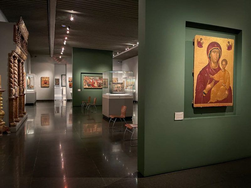
## Description The Benaki Museum is one of Athens’ most important cultural institutions because it presents Greek history and identity through a broad and thoughtful collection rather than a narrow single-theme display. Visitors who come expecting one type of museum often discover that the Benaki is much more expansive. It includes art, objects, clothing, religious items, decorative works, and material from different periods that together tell a layered story of Greek civilization and cultural continuity. What makes the museum especially compelling is the way it links antiquity, Byzantium, Ottoman-era influence, and modern Greek identity without treating them as separate islands. The collection helps you understand that Greece’s cultural history is not only classical. It is long, evolving, and regionally diverse. That broader perspective is one of the museum’s great strengths. It is also why the Benaki is so useful to travelers who want to go beyond postcard versions of Athens. One lesser-known fact is that the museum began as a private collection before growing into one of the country’s key public cultural institutions. Another is that its displays often reward viewers who pay attention to craftsmanship and everyday materials, not just monumental masterpieces. The result is a museum that feels intellectually rich but still accessible. You do not have to be an expert to enjoy it, though you will likely get more from it if you are interested in how objects carry cultural memory. The Benaki is also appealing because it offers a calmer, more curated counterpoint to the dramatic scale of Athens’ ancient ruins. After time at the Acropolis or major archaeological sites, the museum gives context to the broader human story behind those stones. It helps connect art, religion, politics, and daily life. For many visitors, that synthesis is exactly what makes the visit worthwhile. ## Location The Benaki Museum is in Athens, Greece, with its main historical building located in central Athens near other major urban and cultural landmarks. Its position makes it very easy to integrate into a day of museum and city-center sightseeing. The easiest way to get there is by public transport, taxi, or on foot depending on where you are staying. Since central Athens is compact enough for many visitors to explore by walking, the museum can often be part of a broader route through nearby neighborhoods and monuments. If you are visiting multiple museums, check the specific branch or main building you plan to see, as the Benaki institution includes multiple sites and collections. It is a good idea to pair the museum with a café stop or another nearby cultural site, especially if you want to keep the day balanced and avoid museum fatigue. ## Tips Allow enough time. This is not a quick museum if you want to appreciate the range of material properly. If possible, read the museum’s room structure or collection focus before entering so you can prioritize areas that match your interests. Do not focus only on the “headline” objects. Some of the most rewarding pieces are the smaller items that reveal everyday life and social change. If you are interested in Greek history across periods, this museum is one of the most useful stops in Athens because it connects those periods in one place. ## Conclusion The Benaki Museum is one of Athens’ finest cultural attractions, offering a wide and intelligent view of Greek history through art and objects. It is an essential stop for travelers who want depth, not just spectacle. ## FAQ **What is the Benaki Museum known for?** It is known for its wide-ranging collection of Greek art and cultural artifacts across multiple historical periods. **How long should I spend there?** Two hours or more is ideal if you want to see the museum properly. **Is it good for first-time visitors to Athens?** Yes, especially if you want historical context beyond ancient ruins. **Does it focus only on ancient Greece?** No. It covers a much broader cultural timeline. **Is it easy to reach?** Yes, it is centrally located and straightforward to access. ## Links - [Official website](https://www.benaki.org/index.php?lang=en) - [Wikipedia](https://en.wikipedia.org/wiki/Benaki_Museum)
GemVoyage Team • World

Comments