GemVoyage Team • World
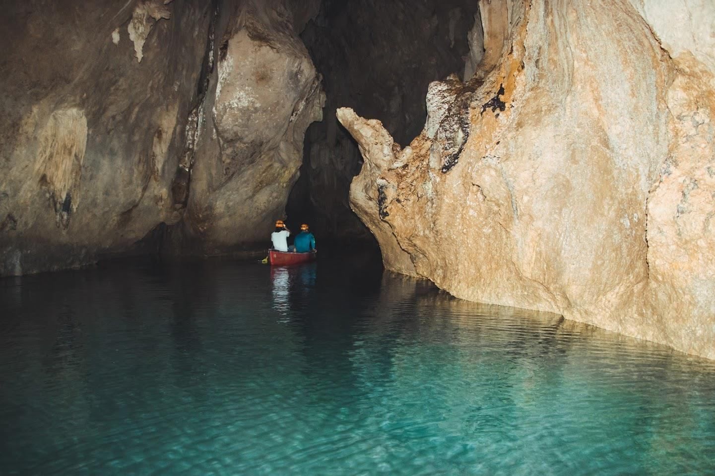
Barton Creek Cave Reserve is one of Belize’s most compelling natural and archaeological attractions, combining dramatic limestone cave formations with deep cultural significance. Located within the lush lowland forests of western Belize, the reserve centers around Barton Creek Cave, a vast subterranean river cave that was once a sacred ceremonial site for the ancient Maya. Today, visitors explore the cave primarily by canoe, gliding silently through dark chambers illuminated only by headlamps and reflected light on the water.
What makes Barton Creek Cave truly unique is this rare combination of active exploration and archaeological context. Unlike many caves that are viewed from walkways, here you move directly through the cave’s interior, following the same water route used by the Maya over a thousand years ago. Inside, towering stalactites, stalagmites, and cathedral-like caverns create an atmosphere that is both awe-inspiring and humbling.
A little-known fact is that the cave was used specifically for rituals connected to the Maya underworld, known as Xibalba. Archaeologists have discovered ceremonial pottery, stone tools, and other ritual objects placed deep within the cave, suggesting it was not used for habitation but for spiritual purposes. Another lesser-known detail is that some ceramic pieces were intentionally broken, consistent with Maya ritual practices meant to “release” spiritual energy.
Despite its popularity, Barton Creek Cave Reserve remains relatively undeveloped. There are no artificial lights inside the cave, preserving its natural state and enhancing the sense of discovery. This rawness, combined with expert local guides, makes the experience both educational and deeply immersive.
Country: Belize
Region: Cayo District
Nearest Town: San Ignacio
Barton Creek Cave Reserve is located approximately 30 kilometers southeast of San Ignacio, in a rural, forested area surrounded by small Maya and farming communities.
* From San Ignacio, drive toward the village of Barton Creek. The final stretch is unpaved and may be rough, especially after rain; a high-clearance vehicle is recommended.
* The most common and convenient option. Tours include transportation, equipment, and licensed guides.
* Possible from San Ignacio, but return arrangements should be planned in advance due to the remote location.
Barton Creek Cave Reserve offers a rare opportunity to experience Belize’s natural beauty and ancient Maya spirituality at the same time. Its canoe-based exploration, untouched cave environment, and archaeological importance make it one of the most memorable and meaningful attractions in the Cayo District.
1. Do I need a guide to visit Barton Creek Cave?
Yes. All visitors must enter with a licensed guide for safety and preservation reasons.
2. Is swimming required?
No. The cave is explored by canoe, and swimming is not necessary.
3. How long does the tour take?
Typically 1.5 to 2 hours, including preparation and exploration.
4. Is the cave suitable for children?
Yes, for older children who are comfortable in dark, enclosed spaces.
5. Can I take photos inside the cave?
Yes, but flash photography may be restricted, and touching formations or artifacts is prohibited.
6. What is the best time of year to visit?
The dry season, from roughly December to May, is generally the best time.
Discover more hidden gems you might love.
Hong Kong
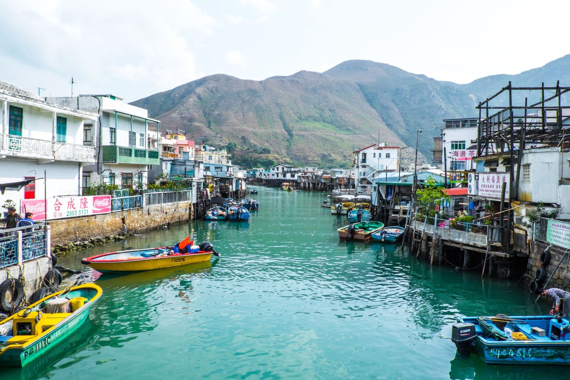
## Description Tai O Fishing Village is one of the most atmospheric places in Hong Kong because it preserves a way of life that feels very different from the city’s skyscraper identity. Located on the western side of Lantau Island, Tai O is known for its stilt houses, narrow waterways, fishing heritage, and the sense that time moves more slowly here than in Hong Kong's urban core. For travelers looking for a place that combines cultural history, coastal scenery, and a strong local character, Tai O delivers all three in a single visit. The village is especially distinctive because it has kept much of its fishing-community layout, even as Hong Kong developed around it. The stilt houses, built above tidal waters and connected by wooden walkways, create a visual landscape that is unique in the region. Boat traffic still matters here, seafood is still central to the local economy, and the village still feels shaped by the rhythms of sea and tide. In the early morning, Tai O can feel hushed and contemplative. Later in the day, it becomes more animated as day visitors arrive, shops open, and boats move in and out of the channels. A little-known fact is that Tai O has long been associated with salt production and trade, not just fishing. Another detail many visitors miss is the old village fortifications and temple structures that reflect how communities once protected themselves from pirates, storms, and the uncertainties of coastal life. The area is therefore not simply picturesque; it is historically layered and reveals a deeper story about how people adapted to Hong Kong's shoreline before modern development changed the coastline. The food here is another major reason to visit. Dried seafood, shrimp paste, sweet treats, and simple local dishes are part of Tai O’s identity, and they help visitors understand how the village economy worked for generations. Even if you only spend half a day here, Tai O can feel like a complete change of pace from the rest of Hong Kong, offering a mixture of water, heritage, and community that is increasingly rare. ## Location Tai O Fishing Village is on the western side of Lantau Island in the Hong Kong Special Administrative Region of China. It sits in the Islands District, far from the dense business cores of Hong Kong Island and Kowloon, which is part of what preserves its quieter character. Because it is not on a major rail line, getting there takes a little planning, but that is also what helps keep the area special. The usual route is to travel by MTR to Tung Chung and then continue by bus toward Tai O. This combination is the most practical for most visitors and gives you a smooth connection from the city’s main transport network. Ferries and cable car routes may also be part of a longer day trip if you are combining Tai O with other parts of Lantau Island. If you prefer a more relaxed pace, many travelers visit as part of a full-day itinerary that includes Ngong Ping and the Big Buddha before continuing to Tai O in the afternoon. Once you arrive, much of the village is best explored on foot, though local boat rides are a memorable way to see the stilt houses from the water. Because the village is compact, it is easy to cover the main areas without rushing, but you should allow extra time for food stops, photographs, and slow wandering. ## Tips Visit early in the day or late in the afternoon if you want softer light and fewer crowds. Midday can be busy, especially on weekends and public holidays, and the village is at its best when you can move slowly and take in the details. Take a boat ride if your schedule allows. Seeing Tai O from the water gives you a better sense of how the stilt houses, waterways, and fishing infrastructure fit together. It also helps explain why the village developed the way it did. If you only walk the streets, you still get a strong impression, but the boat perspective adds depth. Try local snacks and dried seafood, but do so with curiosity rather than haste. Many travelers rush through Tai O, take a few photos, and leave without understanding the food culture that has shaped the village for years. Sampling something local makes the visit more meaningful. Wear comfortable shoes and bring sun protection. Tai O is relatively easy to walk, but the experience is more enjoyable when you are prepared for heat, humidity, and a fair amount of time outdoors. If the weather looks unstable, check conditions before you go, since coastal villages are more sensitive to storms and heavy rain. ## Conclusion Tai O Fishing Village offers a rare glimpse of Hong Kong's coastal past, with stilt houses, local food, and a slower rhythm that gives the village a memorable sense of place. ## FAQ ### Why is Tai O famous? Tai O is famous for its stilt houses, fishing heritage, scenic waterways, and its reputation as one of the last traditional fishing villages in Hong Kong. ### How long should I spend in Tai O? Most visitors spend half a day to a full day, depending on whether they plan to add boat rides, food stops, or nearby Lantau attractions. ### Is Tai O easy to reach from central Hong Kong? It takes some planning, but it is straightforward by taking the MTR to Tung Chung and then continuing by bus. ### What should I eat in Tai O? Try local seafood snacks, dried seafood products, and village specialties from small shops and street-side vendors. ## Links - [Discover Hong Kong](https://www.discoverhongkong.com/) - [Wikipedia article](https://en.wikipedia.org/wiki/Tai_O)
GemVoyage Team • World
Paris
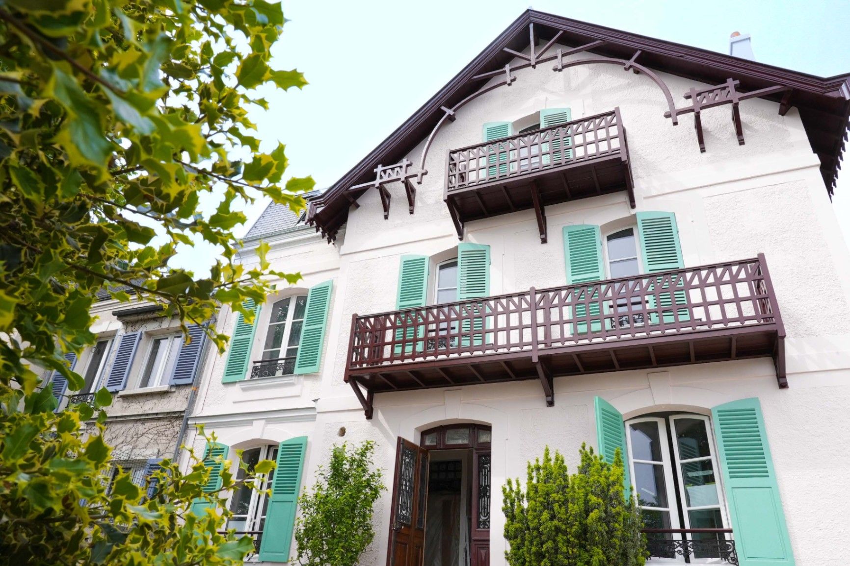
## Description **Maison Impressionniste Claude Monet Argenteuil** is a carefully reconstructed space dedicated to the years when Claude Monet lived and worked in Argenteuil, a suburb northwest of Paris. Although not the original residence, the house functions as a faithful evocation of Monet’s daily environment between 1871 and 1878, a period widely considered formative for the **Impressionist movement**. This is where Monet refined his techniques of capturing light, atmosphere, and everyday scenes, and where he produced some of his most celebrated works, including views of the Seine, gardens, and his own home life. The house is arranged to resemble the domestic context that influenced Monet’s early mastery. Rooms are curated with period furniture, reproductions of key paintings, personal objects, and interpretive displays illustrating how Monet painted outdoors, how he experimented with color, and how Argenteuil became a meeting point for artists such as Renoir, Manet, and Sisley. The staging provides an accessible narrative of Monet as a young pioneer, long before his later fame at Giverny. A little-known fact is that Argenteuil was once a **boating and leisure capital** for Parisians, and Monet frequently painted regattas and pleasure craft from the riverbanks near his home. Another lesser-known detail is that Monet’s time in Argenteuil coincided with substantial urban development, which threatened some of the very landscapes he painted. This tension between modernization and natural beauty appears subtly throughout his Argenteuil canvases. Today, the Maison Impressionniste offers a more intimate and less crowded alternative to major Impressionist institutions in Paris. It gives visitors the chance to walk through reconstructed interiors that feel personal rather than monumental and to understand the roots of what would become Monet’s global artistic influence. ## Location **City:** Argenteuil (Greater Paris area) **Region:** Île-de-France **Country:** France The house is situated in a residential part of Argenteuil, within walking distance of the Seine and the locations that inspired many of Monet’s paintings. ### How to Get There * **By train:** * From **Gare Saint-Lazare** in Paris, take a Transilien J train to **Argenteuil Station**. From there, it is a short walk or a brief bus ride. * **By bus:** * Several suburban bus lines connect Argenteuil with northern districts of Paris. * **By car:** * The area is accessible via the A15 or A86, but parking can be limited in residential streets. * **On foot from the center of Argenteuil:** * A pleasant 10–15 minute walk through town streets leads directly to the museum. ## Tips * **Visit on a weekday** to avoid periods when small tour groups pass through. * **Combine it with a Seine riverside walk**, retracing the landscapes Monet depicted in his Argenteuil period. * **Plan 45–60 minutes**, as the museum is compact but detailed. * **Photography policies may vary**, so check signage before taking photos inside. * **The museum often hosts temporary exhibits** on Impressionism and plein-air painting; check ahead for program changes. * **Bring context:** Reviewing Monet’s Argenteuil works beforehand will enrich the visit, as many are referenced in the interpretive materials. ## Conclusion Maison Impressionniste Claude Monet Argenteuil offers an intimate and historically grounded perspective on Monet’s early Impressionist years. The reconstructed spaces, the focus on daily life, and the proximity to the landscapes that shaped his artistic eye make it a meaningful stop for those seeking a deeper understanding of how Impressionism emerged and matured. ## FAQ **1. Is the house original?** No. It is a faithful reconstruction designed to evoke Monet’s home during his Argenteuil years. **2. How long did Monet live in Argenteuil?** From 1871 to 1878, a key period of his early Impressionist development. **3. Can visitors see original artworks?** The museum primarily displays reproductions and interpretive materials; original works are held in major museums in Paris and abroad. **4. Is the visit suitable for children?** Yes. The rooms are accessible, and the museum offers educational materials for younger visitors. **5. How long should I plan for the visit?** Around 1 hour, depending on reading speed and interest in the exhibits. **6. Is the museum wheelchair accessible?** Accessibility can vary; checking ahead with the museum is recommended. ## Links * [Official tourism information for Argenteuil](https://www.argenteuil.fr)
GemVoyage Team • World
Cairo
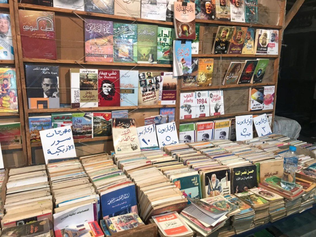
## Description Al-Azbakiyya Wall Book Market, known in Arabic as سور الأزبكية, is one of Cairo’s most distinctive and culturally rich attractions. Located near the historic Azbakeya Gardens, this open-air book market has long been a gathering place for readers, students, and collectors in search of affordable books and rare printed materials. The market is famous for its rows of simple stalls and tables stacked high with books covering every imaginable subject, from classical Arabic literature and religious texts to modern novels, academic works, and children’s books. What makes Al-Azbakiyya Wall Book Market unique is its role in preserving and circulating literary heritage at accessible prices. Many of the books sold here are second-hand, out-of-print, or rescued from private libraries, making the market a haven for hidden literary gems. A lesser-known fact is that some vendors specialize in vintage magazines, old school textbooks, and early 20th-century publications that are difficult to find elsewhere. Another interesting detail is that the market becomes especially lively during the annual Cairo International Book Fair, when sellers temporarily relocate to fairgrounds while maintaining the spirit of the original market. Beyond commerce, Sur Al-Azbakiyya represents Cairo’s deep-rooted intellectual culture, offering visitors a chance to engage with the city’s literary soul in an informal and welcoming setting. ## Location Al-Azbakiyya Wall Book Market is located in **Egypt**, in the **Cairo Governorate**, within **central Cairo**. It is situated near **Ataba Square**, close to the Azbakeya Gardens and within walking distance of several historic and commercial areas. The market is easily accessible by public transportation. The **Ataba Metro Station** serves Lines 2 and 3 and is the most convenient way to reach the area. Numerous buses and minibuses also stop nearby. Due to heavy traffic and limited parking, public transport or walking from nearby districts is strongly recommended. ## Tips * Visit in the morning to browse comfortably before the area becomes crowded. * Take your time and explore multiple stalls, as prices and selections can vary widely. * Bargaining is common and generally expected, but should be done politely. * Bring cash in small denominations, as most vendors do not accept electronic payments. * If you are looking for rare or academic books, ask vendors directly—they often keep special items tucked away. * Be mindful of your belongings, as the area can be busy. ## Conclusion Al-Azbakiyya Wall Book Market is a living cultural institution that reflects Cairo’s love for knowledge, literature, and learning. Whether you are searching for rare books or simply soaking in the atmosphere, it offers a unique and deeply local experience in the heart of the city. ## FAQ **What kind of books can I find at Al-Azbakiyya Wall Book Market?** You can find a wide range of books, including Arabic literature, religious texts, textbooks, novels, magazines, and children’s books. **Are the books new or used?** Most books are second-hand or older editions, though some new and reprinted titles may also be available. **Is the market open every day?** The market is generally open daily, though hours may vary and some stalls close on Fridays. **Can tourists who do not speak Arabic visit?** Yes, visitors are welcome, though knowledge of Arabic helps when browsing and negotiating. **Is photography allowed?** Photography is usually allowed, but it is polite to ask vendors before taking photos. ## Links * [Wiki page](https://ar.wikipedia.org/wiki/%D8%B3%D9%88%D8%B1_%D8%A7%D9%84%D8%A3%D8%B2%D8%A8%D9%83%D9%8A%D8%A9)
GemVoyage Team • World
Juodkrantė
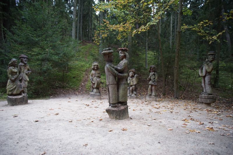
## Description The Hill of Witches (Raganų Kalnas) near Juodkrantė is an outdoor open-air gallery where folklore and forest meet. Carved wooden sculptures—dozens of them—depict figures from Lithuanian myths, pagan legends, and fairytales, arranged along a winding forest path that rises toward the Dune Rim. This combination of art and natural setting creates a narrative walk: each sculpture is a tableau within the pine woods, offering an immersive way to learn about Baltic mythology while enjoying the seaside atmosphere of the Curonian Spit. Little-known facts: many sculptures are replaced or restored periodically because of the coastal weather; the site has also hosted temporary contemporary art installations connecting modern voices to age-old tales. Additionally, the hill was intentionally designed to blend with the natural dune and forest so that the art feels like an organic part of the landscape rather than an imposition. The site is both poetic and family-friendly, with hauntingly beautiful carvings that are approachable for children while thought-provoking for adults. Seasonal cultural events sometimes include storytelling evenings and folklore workshops. ## Location Raganų Kalnas is on the Curonian Spit, an elongated sand dune peninsula that separates the Curonian Lagoon from the Baltic Sea, in western Lithuania. The hill lies near the small resort village of Juodkrantė in Neringa municipality, Klaipėda County. How to get there: Neringa is reachable by ferry or car via Klaipėda and then over the Curonian Spit road; public buses connect Klaipėda with Nida and other Spit settlements. From Juodkrantė center, the Hill of Witches is an easy walk along marked paths. ## Tips - Visit early morning or late afternoon to avoid crowds and capture the soft light through the pines. - Wear sturdy shoes—the path can be sandy and uneven. - Bring a guidebook or download a map to understand the individual sculptures and stories. - Check for temporary exhibitions or cultural events—these often enhance the experience. - Combine the visit with a walk along the nearby dunes or a ferry ride on the Curonian Lagoon. ## Conclusion The Hill of Witches is a uniquely Baltic blend of art, folklore, and landscape: a short visit on the Curonian Spit that leaves a lasting impression through its carved narratives and coastal forest atmosphere. ## FAQ Q: Is the Hill of Witches accessible year-round? A: Yes, but winter weather can be harsh; spring through autumn is optimal. Q: Are the sculptures original? A: Many are original but are periodically replaced or restored due to weathering. Q: Is there an entrance fee? A: There may be a modest fee for some event programs, but the site is generally free to visit. Q: Can I bring children? A: Yes—children usually enjoy the sculptural storytelling. ## Links - [Hill of Witches (Wikipedia)](https://en.wikipedia.org/wiki/Hill_of_Witches)
GemVoyage Team • World
Siberia
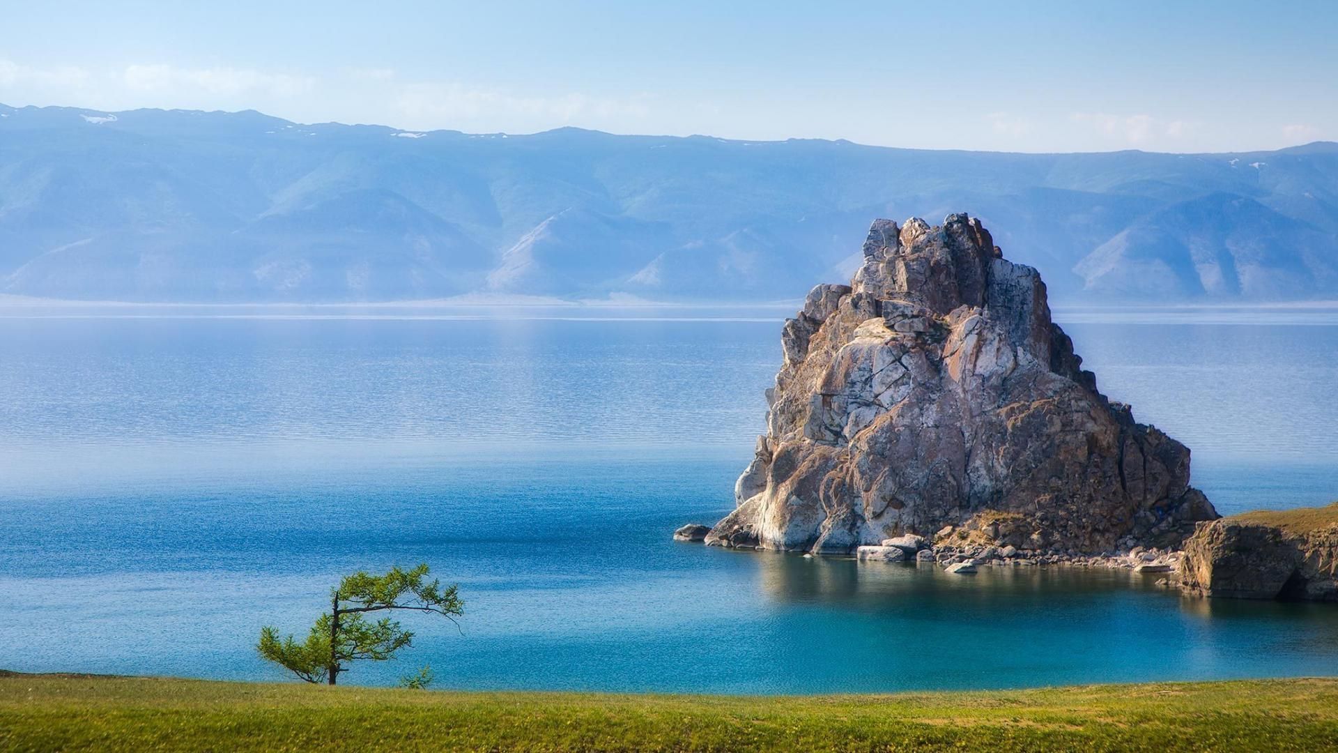
## Description Lake Baikal in southern Siberia is a global natural wonder: the world’s deepest and one of its oldest freshwater lakes, it holds roughly 20% of the planet’s unfrozen surface freshwater by volume. Stretching over 600 kilometers north-to-south and reaching depths of more than 1,600 meters, Baikal’s sheer scale is awe-inspiring. The lake’s crystalline waters, dramatic rifts, and seasonal extremes produce striking phenomena — from the unbelievable clarity of summer waters to the otherworldly expanses of transparent winter ice that allow you to walk, drive, or even ice-sail across a dazzling frozen surface. Baikal is also a hotspot of biodiversity and scientific interest. Its shoreline, submerged terraces, and deep basins host numerous endemic species found nowhere else on Earth, including the Baikal seal (nerpa) — the only seal species that has adapted to a fully freshwater environment — and dozens of endemic fish and invertebrates. The lake’s unique ecology is the result of millions of years of relative isolation, stable cold temperatures at depth, and complex nutrient cycling. Scientists study Baikal to better understand limnological processes, long-term climate records trapped in sediment layers, and the evolution of isolated ecosystems. For travelers, Baikal delivers a rare combination of dramatic landscapes and varied activities across seasons. In summer, the shoreline blooms with wildflowers, and mountain hikes and multi-day treks through taiga and steppe reveal panoramic views over the water. Kayaking, boat excursions, and shoreline camping let you sample the lake’s nearshore biodiversity and peaceful beaches. In winter, when the lake freezes, the surface becomes a vast frozen highway: locals and guides lead safe ice-walking excursions, cross-lake snowmobile trips, ice-fishing experiences, and festivals that celebrate the season. Photographers prize Baikal for its vivid ice formations, clear reflections, and light at dawn and dusk. Beyond natural spectacle, Baikal is threaded with human stories: small lakeside towns such as Listvyanka, the ferry-served Olkhon Island with its shamanic sites, and the city of Irkutsk — a historical gateway with Siberian wooden architecture and museums — are rich portals into local culture. Sustainable and low-impact travel is increasingly available via small-scale guesthouses, ecotour operators, and community-led tours that prioritize the lake’s protection. ## Location Lake Baikal spans the regions of Irkutsk Oblast and the Republic of Buryatia in Russia, with the lake forming a striking spine across southeastern Siberia. The city of Irkutsk is the primary gateway for international and domestic visitors, linked by the Trans-Siberian Railway and regional flights; it offers accommodations, museums, and transport connections. From Irkutsk, paved roads and seasonal bus services reach lakeside settlements like Listvyanka, Port Baikal, and the ferry terminals for Olkhon Island — the lake’s largest island and a cultural heartland with cliffs, shamanic sites, and small villages. Other access points include Ulan-Ude to the east and smaller regional airfields that connect via charter or seasonal flights. Travel times can be long, so many visitors plan multi-day itineraries that combine transit into the lake area with on-site exploration. ## Tips - **Respect seasonal access and local rules:** Ice travel and remote trails require local knowledge; always consult local guides and authorities before venturing onto the ice or into isolated areas. Safety equipment and up-to-date conditions are essential. - **Plan time for Olkhon Island:** Olkhon is a cultural and scenic highlight, with dramatic cliffs, shamanic sites, and small settlements. Allow several days to explore its coves, beaches, and sacred capes. - **Pack for extremes:** Even in summer, weather can shift quickly; bring layered clothing, waterproof shells, sturdy boots, sun protection, and insect repellent. In winter, prioritize thermal layers, insulated boots, and a reliable outer layer. - **Travel with experienced local guides:** Guides provide safety on ice crossings, access to lesser-known shorelines, wildlife-spotting skills, and cultural context about Buryat and Siberian heritage. Choose operators that practice sustainable tourism. - **Respect conservation rules:** Stick to marked paths, avoid disturbing nesting birds or haul-out sites, and follow Leave No Trace principles. Support local conservation initiatives when possible. - **Time your visit for activities:** Summer is best for hiking and kayaking; late spring and early autumn deliver fewer crowds and pleasant light; winter offers unique ice experiences but requires more planning. ## Conclusion Lake Baikal is both a living laboratory and a vast natural wonder: its depth, clarity, and ancient lineage make it one of Earth’s most singular freshwater realms. Whether you come for scientific curiosity, wilderness hiking, cultural exchange with lakeside communities, or simply to witness impossibly clear water and glass-like ice, Baikal rewards patient travel and respectful exploration. Plan carefully, choose sustainable operators, and allow enough time to move slowly around its bays and islands — the lake’s scale is best absorbed at human pace. ## FAQ - **Q: Can you swim in Lake Baikal?** A: Swimming is possible in summer at sheltered beaches and near lakeside villages, but the water remains cold even in peak months; stay near lifeguarded or popular swimming areas, enter gradually to avoid shock, and follow local safety guidance. - **Q: What is the best time to visit Lake Baikal?** A: Late June through September gives the warmest weather, flowering meadows, and easier trekking. Late winter (February–March) is ideal for ice-scenery photography and safe ice excursions when the ice is thickest and the light is crisp. Shoulder seasons offer quieter conditions. - **Q: How do I reach Olkhon Island, and do I need a vehicle?** A: Olkhon is reached via a seasonal ferry or ice road depending on the time of year. Many visitors rent 4x4 vehicles or join guided tours; public buses operate from nearby towns but capacity is limited. Plan logistics in advance, especially in peak season. - **Q: Are there wildlife viewing opportunities?** A: Yes—local guides can help you spot endemic fish species, waterbirds, and in protected offshore areas you may observe Baikal seals. Respect distance guidelines and avoid disturbing habitats. - **Q: Do I need special permits or visas to visit?** A: International visitors need a valid Russian visa. Some protected areas require entry fees or permits for camping and research; check with regional park authorities for up-to-date rules. - **Q: Is Internet and phone coverage available?** A: Coverage varies—cities like Irkutsk and larger settlements have decent mobile data; more remote shorelines and parts of Olkhon have limited connectivity. Prepare for periods offline and download maps or emergency contacts beforehand. ## Links -- [Lake Baikal — Wikipedia](https://en.wikipedia.org/wiki/Lake_Baikal)
GemVoyage Team • World
Baalbek
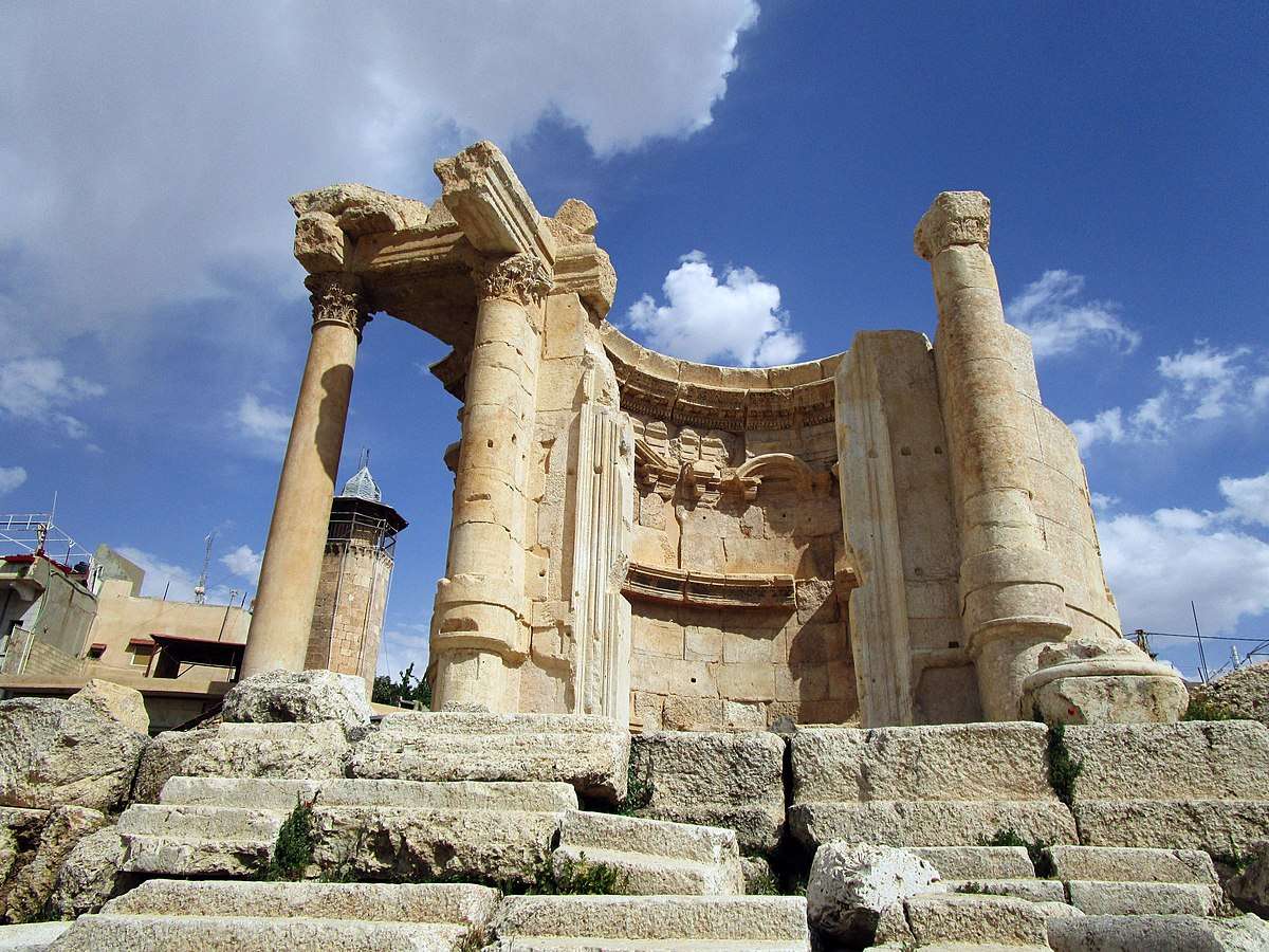
## Description The Temple of Venus in Baalbek, Lebanon, is a captivating remnant of Roman architecture and religious history, tucked within one of the most impressive archaeological complexes in the Middle East. Built in the 3rd century AD, this temple stands out for its **unusual circular design**, a departure from the more common rectangular Roman temples. It was dedicated to Venus, the Roman goddess of love and beauty, and its elegant structure reflects the sensuality and grace associated with her worship. Unlike the colossal temples of Jupiter and Bacchus nearby, the Temple of Venus is more intimate in scale but no less remarkable. It sits atop a horseshoe-shaped platform and features a circular shrine with a square entrance. The outer façade is adorned with five niches, each decorated with carvings of doves and shells—symbols traditionally linked to Venus. These details, along with the temple’s baroque-style curves and arches, showcase a fusion of Roman and Hellenistic architectural techniques. A little-known fact: the temple was later converted into a Christian church dedicated to Saint Barbara, a martyr whose legend is still revered in Lebanon. According to tradition, she was killed by her pagan father for converting to Christianity, and the temple’s continued use as a sacred site reflects the layered religious history of Baalbek. Today, a small mosque stands nearby, underscoring the site’s enduring spiritual significance across centuries and faiths. ## Location The Temple of Venus is located in **Lebanon**, within the **Baalbek-Hermel Governorate**, in the ancient city of **Baalbek**. This city lies in the **northern Bekaa Valley**, a region known for its fertile lands and rich historical tapestry. ### How to Get There: - **By Car**: From Beirut, Baalbek is about a 2-hour drive northeast. The route via Zahle offers scenic views of the Bekaa Valley. - **By Bus**: Public minibuses run from Beirut’s Cola Station to Baalbek, though schedules can be irregular. - **By Tour**: Many guided tours from Beirut include Baalbek’s temple complex, often paired with visits to Anjar or Ksara Winery. Once in Baalbek, the Temple of Venus is just a short walk from the main entrance to the Roman ruins, southeast of the Temple of Jupiter. ## Tips for Visitors To make the most of your visit to the Temple of Venus, consider these tips: - **Visit Early or Late**: The site can get hot and crowded midday. Morning or late afternoon offers better lighting and fewer tourists. - **Wear Comfortable Shoes**: The terrain is uneven, with ancient stones and gravel paths. - **Hire a Guide**: A local guide can provide rich historical context and point out hidden details you might miss. - **Respect the Site**: This is a sacred and historical location. Avoid climbing on ruins or touching carvings. - **Bring Water and Sunscreen**: The Bekaa Valley can be dry and sunny, especially in summer. - **Explore the Whole Complex**: Don’t miss the nearby temples of Jupiter and Bacchus, which are among the largest Roman temples ever built. ## Conclusion The Temple of Venus in Baalbek is a graceful and historically rich monument that offers a unique glimpse into Roman spirituality, architectural innovation, and Lebanon’s layered religious heritage. Its elegant design and enduring presence make it a must-visit for history lovers and curious travelers alike. ## FAQ **1. When was the Temple of Venus built?** It was constructed in the 3rd century AD during the Roman Empire. **2. What makes the Temple of Venus unique?** Its circular design, horseshoe-shaped platform, and symbolic carvings distinguish it from typical Roman temples. **3. Is the temple part of a larger complex?** Yes, it’s part of the Baalbek temple complex, which includes the massive temples of Jupiter and Bacchus. **4. Can I visit the temple year-round?** Yes, the site is open daily and accessible throughout the year. **5. Is there an entrance fee?** Yes, entry to the Baalbek ruins requires a ticket, which includes access to the Temple of Venus. **6. Is the site family-friendly?** Absolutely. The complex is suitable for children and offers a fascinating educational experience. ## Links - [Baalbek Temple of Venus – Livius Ancient History](https://www.livius.org/articles/place/heliopolis-baalbek/baalbek-photos/baalbek-temple-of-the-venus/)
GemVoyage Team • World

Comments