GemVoyage Team • World
Viktoriapark is one of Berlin’s most distinctive urban green spaces, combining natural elevation, engineered waterfalls, panoramic city views, and national symbolism within a compact yet dramatic landscape. Unlike Berlin’s vast flat parks such as Tiergarten or Tempelhofer Feld, Viktoriapark stands out because it rises sharply above the surrounding streets, offering one of the best natural viewpoints in the entire city.
The park is centered around Kreuzberg Hill, a 66-meter-high elevation that gives the surrounding district its name. At the summit stands the imposing National Monument for the Wars of Liberation (Nationaldenkmal für die Befreiungskriege), a Gothic-style cast-iron monument designed by Karl Friedrich Schinkel and completed in 1821. The monument commemorates Prussia’s victory over Napoleon and represents one of the earliest major patriotic memorials in Germany. Its dark, spired form creates a dramatic silhouette against the sky and serves as a visual anchor for the entire park.
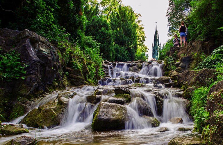
One of Viktoriapark’s most beloved features is its artificial waterfall system, which cascades down the eastern slope of the hill toward Kreuzbergstraße. Built in the late 19th century, the waterfall was designed to mimic alpine mountain streams, bringing the sound, movement, and cooling atmosphere of flowing water into the dense urban fabric. During warm months, these waterfalls become the emotional heart of the park—children play at the base, couples sit on the stone steps, and photographers wait for light to catch the moving water.
What makes Viktoriapark particularly compelling is the way it merges romantic landscape design with political history. The hill was reshaped during the 19th century to fit the ideals of romantic nationalism, where nature, sacrifice, and monumentality were meant to reinforce each other. The result is a park that feels both organic and highly symbolic at the same time.
A little-known fact is that Kreuzberg Hill was once part of a vine-growing region, and small-scale wine production existed here in earlier centuries. Even today, a modern vineyard operates on the slope near the monument, producing limited local wine each year. Another lesser-known detail is that the waterfall only runs during the warmer months, meaning many winter visitors never realize that this dramatic feature exists at all.
Beyond its historical symbolism, Viktoriapark plays a vital role in everyday neighborhood life. It is a local refuge for residents of Kreuzberg, attracting joggers, families, musicians, dog walkers, and sunset watchers. Unlike some of Berlin’s more monumental parks, Viktoriapark maintains a distinctly neighborhood-driven character, blending tourism and local daily rhythm without feeling staged.
Emotionally, the park shifts moods throughout the day. Mornings are quiet and misty along the lower paths. Afternoons bring activity and movement. Evenings transform the summit into a gathering point for people watching the sun sink behind Berlin’s rooftops. From the top, visitors can often see landmarks such as the TV Tower (Fernsehturm) and distant church spires, reinforcing the sense of standing above the city without ever leaving it.
Viktoriapark is located in the Kreuzberg district of central Berlin, close to the border with Schöneberg.
City: Berlin
Region: Berlin (city-state)
Country: Germany
District: Kreuzberg (Friedrichshain-Kreuzberg borough)
* Line U6 to Platz der Luftbrücke, then walk about 10 minutes.
* Line U7 to Mehringdamm, then walk about 12–15 minutes.
The park’s elevated position makes it visible from many surrounding streets, acting as a natural landmark within Kreuzberg.
Viktoriapark is a rare Berlin green space where natural elevation, romantic landscape design, national history, and everyday local life intersect. From its cascading waterfalls and shaded paths to the solemn monument crowns its summit, the park offers both emotional contrast and visual depth. It is not grand in size, but in experience, symbolism, and atmosphere, it ranks among the most memorable outdoor spaces in the city.
1. What is Viktoriapark famous for?
It is best known for its hilltop national monument, artificial waterfalls, and panoramic city views.
2. Is Viktoriapark suitable for children?
Yes. Families visit frequently, especially near the lower waterfall areas, though supervision is required due to rocky terrain.
3. Is there an entrance fee?
No. Viktoriapark is free and open to the public.
4. Does the waterfall run all year?
No. It usually operates only during the warmer months.
5. Can you see major landmarks from Viktoriapark?
Yes. On clear days, you can spot parts of the Berlin skyline including the TV Tower.
6. How long should a visit take?
Most visits last 45 minutes to 1.5 hours, depending on walking pace and time spent at viewpoints.
Discover more hidden gems you might love.
Aswan
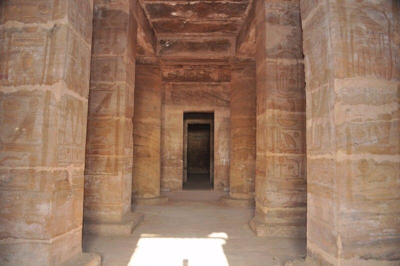
## Description **The Temple of Amada** is one of the oldest surviving stone temples in Nubia and a remarkable example of **New Kingdom Egyptian architecture** outside the Nile Valley’s main centers. Built during the reigns of **Thutmose III** and **Amenhotep II** in the 18th Dynasty (15th century BCE), the temple was dedicated to the gods **Amun-Re** and **Re-Horakhty**. While modest in size compared to the great temples of Luxor, Amada’s historical and artistic value is exceptionally high. What makes the Temple of Amada unique is its **well-preserved interior inscriptions**. The walls are covered with detailed reliefs and hieroglyphic texts that document military campaigns in Nubia and the Near East. One inscription records a victory so overwhelming that it claims the stench of defeated enemies filled the land—an unusually vivid and rare narrative detail in Egyptian temple texts. A lesser-known but crucial fact is that the temple originally stood several kilometers south of its current location. During the 1960s, it was **relocated intact** as part of UNESCO’s Nubian Monuments rescue campaign, launched to save ancient sites threatened by flooding from the construction of the Aswan High Dam. Unlike Abu Simbel, which was cut into blocks, the Temple of Amada was moved as a **single structure**, an extraordinary engineering achievement that preserved its fragile wall paintings. The temple’s proportions are elegant and restrained, with a small pylon, open courtyard, hypostyle hall, and sanctuary. Its compact scale allows visitors to closely study reliefs and inscriptions without the overwhelming crowds found at larger sites, making it especially rewarding for those interested in Egyptian history and epigraphy. ## Location **Country:** Egypt **Region:** Upper Egypt / Nubia **Nearest City:** Aswan The Temple of Amada is located approximately **20 kilometers south of Aswan**, near Lake Nasser, close to the modern village of New Amada. ### How to Get There * **By guided tour:** * Most visitors reach Amada as part of a **Lake Nasser archaeological tour**, either by road or boat. * **By car:** * Accessible via the Aswan–Abu Simbel road, though permits may be required for independent travel. * **By cruise boat:** * Some Lake Nasser cruises include Amada as a scheduled stop. ## Tips * **Visit with a guide:** The inscriptions are historically rich but easy to miss without explanation. * **Allow time inside:** The temple’s value lies primarily in its interior reliefs, not its exterior. * **Bring sun protection:** The site is exposed, and shade is limited. * **Photography is allowed:** Flash should be avoided to protect the wall paintings. * **Combine with nearby sites:** The temples of Derr and the Tomb of Pennut are often visited together. * **Best visited in winter:** Cooler temperatures make exploration far more comfortable. ## Conclusion The Temple of Amada is a quiet but powerful witness to Egypt’s imperial presence in Nubia. Its vivid inscriptions, elegant design, and dramatic modern relocation make it one of the most historically important yet underrated ancient temples in southern Egypt. ## FAQ **1. When was the Temple of Amada built?** It dates to the 18th Dynasty, primarily during the reigns of Thutmose III and Amenhotep II. **2. Why was the temple moved?** It was relocated to prevent flooding caused by the creation of Lake Nasser after the Aswan High Dam. **3. Is the temple original or reconstructed?** It is original; the entire structure was moved intact rather than rebuilt from blocks. **4. How long does a visit take?** Approximately **30–60 minutes**, depending on interest in inscriptions. **5. Is it crowded?** No. It is much quieter than major temples along the Nile. **6. Is the site suitable for casual visitors?** Yes, though history enthusiasts will appreciate it the most. ## Links * [Egypt tourism portal](https://www.experienceegypt.eg/en)
GemVoyage Team • World
Tokyo
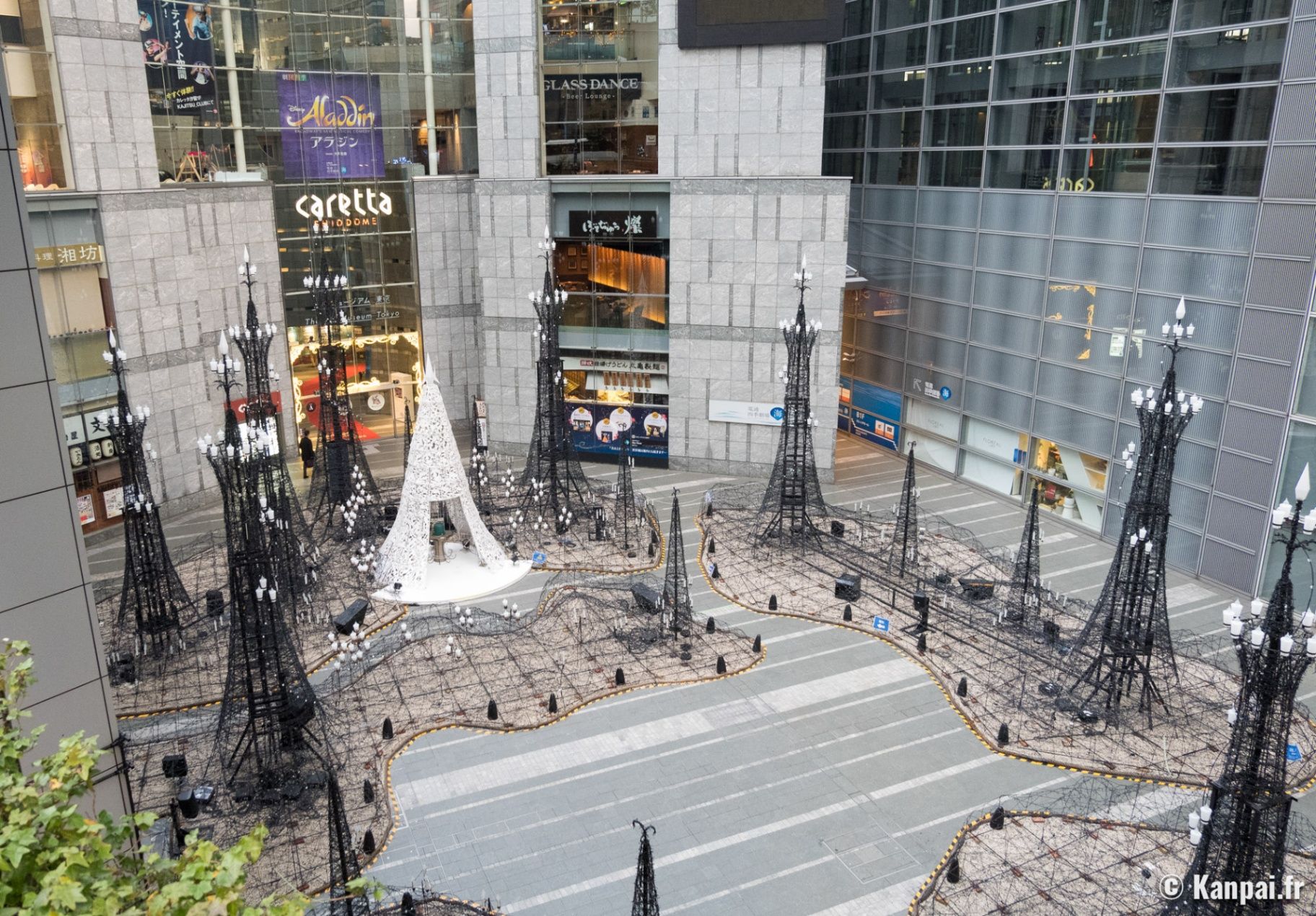
## Description **Caretta Shiodome (カレッタ汐留)** is a striking skyscraper complex in the **Shiodome district** of **Tokyo**, Japan, that perfectly embodies the city’s modern sophistication and cultural vibrancy. Rising 51 stories above the bustling streets of Minato Ward, this landmark blends **shopping, dining, art, and entertainment** into one of Tokyo’s most polished urban experiences. Opened in **2002**, Caretta Shiodome is part of the Shiodome redevelopment project that transformed an old railway yard into a futuristic business and leisure zone. Inside, visitors will find an elegant mix of **restaurants, boutique shops, a theater, a museum, and panoramic observation areas** — all designed with contemporary style and efficiency. What makes Caretta Shiodome truly unique is its seamless combination of **commerce and culture**. It houses the **Caretta Shiodome Sky View**, an observation area on the 46th floor offering spectacular views of Tokyo Bay, Odaiba, and the Rainbow Bridge. The complex is also home to the **Advertising Museum Tokyo (ADMT)**, Japan’s only museum dedicated to the history of advertising — a fascinating and often overlooked gem that reveals how Japanese media and design evolved over the decades. Another standout feature is the **Caretta Illumination**, one of Tokyo’s most beloved **winter light displays**. Each year, from November through February, the plaza outside the building is transformed into a glittering wonderland of over **250,000 LED lights**, synchronized to music. It attracts couples, photographers, and families alike, and has become a symbol of Tokyo’s festive season. A lesser-known fact is that Caretta Shiodome’s name, “Caretta,” is derived from *Caretta caretta*, the Latin name for the **loggerhead sea turtle**, symbolizing endurance, longevity, and connection to the ocean — an apt metaphor for Tokyo’s harmony between progress and nature. ## Location Caretta Shiodome is located in the **Shiodome district** of **Minato Ward**, **Tokyo, Japan**. It sits within the Shiodome City Center area, just a short walk from **Shimbashi Station** and surrounded by major landmarks like the **Hamarikyu Gardens** and **Ginza**. To get there: * **By train:** * Take the **Toei Ōedo Line** or **Yurikamome Line** to **Shiodome Station** (direct underground access). * Alternatively, take the **JR Yamanote Line** or **Tokyo Metro Ginza Line** to **Shimbashi Station**, and walk about **5 minutes** via underground passages. * **By foot:** It’s a pleasant 10-minute walk from **Ginza** or **Tsukiji** areas. * **By car:** Paid parking is available in the basement levels, though public transport is highly recommended due to central Tokyo traffic. ## Tips * **Visit during the evening:** Especially in winter, when the **Caretta Illumination** lights up the plaza with dazzling colors and music. * **Go up to the 46th or 47th floors:** For a **free panoramic view** of Tokyo Bay — one of the best free observation spots in the city. * **Dine with a view:** Restaurants like **Sky View Dining and Bar** or **KAIKAYA Shiodome** offer gourmet meals paired with sweeping skyline vistas. * **Visit the Advertising Museum Tokyo (ADMT):** Admission is free, and it’s an engaging stop for design enthusiasts and marketers. * **Combine with nearby attractions:** The **Hamarikyu Gardens** and **Ginza shopping district** are within walking distance. * **Check event schedules:** Seasonal exhibitions, performances, and cultural events are regularly held within the complex. * **Best time to visit:** Late afternoon to evening — explore the shops and museum first, then stay for dinner and the illumination. ## Conclusion **Caretta Shiodome** is a shining example of modern Tokyo — a place where art, architecture, and lifestyle converge high above the city streets. From its world-class restaurants and free observation decks to its mesmerizing light displays and creative museum, it offers something for everyone. Whether you’re looking to dine with a skyline view, learn about Japan’s advertising culture, or simply soak in the illuminated atmosphere of Tokyo at night, Caretta Shiodome delivers a distinctly urban yet deeply memorable experience. ## FAQ **1. What is Caretta Shiodome?** It’s a high-rise complex in Tokyo that features **shopping, dining, a theater, the Advertising Museum Tokyo, and seasonal events** like the Caretta Illumination. **2. Where is it located?** At **1-8-2 Higashi-Shimbashi**, **Minato-ku**, **Tokyo**, within walking distance from **Shiodome Station** and **Shimbashi Station**. **3. Is there an observation deck?** Yes — the **Sky View on the 46th and 47th floors** offers **free access** to stunning views of Tokyo Bay and the skyline. **4. What is the Caretta Illumination?** A famous **winter light display** that transforms the plaza into a sea of LED lights, usually from **November to February** each year. **5. Is the Advertising Museum Tokyo free?** Yes, **entry is free**, and it’s a must-visit for those interested in Japanese advertising, pop culture, and design history. **6. Are there restaurants with views?** Yes, several high-end restaurants and bars offer panoramic dining experiences overlooking Tokyo Bay and the Shiodome area. ## Links * [Official Caretta Shiodome Website](https://www.caretta.jp/foreign/index)
GemVoyage Team • World
Alexandria
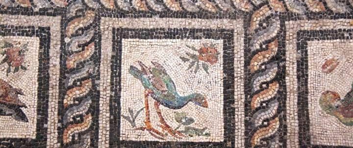
## Description The Roman Villa of the Birds is one of Alexandria’s most fascinating yet often overlooked archaeological sites. Discovered in the early 20th century, this Roman-era villa is renowned for its exceptionally well-preserved floor mosaics, particularly the famous mosaic depicting a variety of birds rendered with remarkable detail and realism. The site offers a rare glimpse into daily life, artistic taste, and luxury in Roman Alexandria, a city that once stood at the crossroads of Mediterranean civilizations. What makes the Roman Villa of the Birds unique is the quality and condition of its mosaics. Unlike many ancient floors that survive only in fragments, the bird mosaic remains largely intact, allowing visitors to appreciate the original composition as it was intended nearly two thousand years ago. The birds are shown in natural poses, each carefully identified by species, reflecting the Roman fascination with nature and decorative art. A little-known fact is that the villa likely belonged to a wealthy Roman official or merchant, as such elaborate mosaics were a clear symbol of status. Another lesser-known detail is that the site was deliberately reburied for protection for many years before being reopened, helping preserve the mosaics from environmental damage and urban expansion. Quiet and atmospheric, the Roman Villa of the Birds provides a more intimate encounter with Alexandria’s ancient past compared to larger, more crowded attractions. ## Location The Roman Villa of the Birds is located in **Egypt**, in the **Alexandria Governorate**, within the city of **Alexandria**. The site is situated in the Kom el-Dikka archaeological area, near other Roman-era remains such as theaters and bath complexes, in the central part of the modern city. Reaching the villa is relatively easy. Visitors can take a taxi from anywhere in Alexandria, as the site is well known among local drivers. Public buses and trams also operate nearby, though taxis are the most convenient option for first-time visitors. Since the site is close to other historical attractions, it is recommended to combine visits on foot once you arrive in the area. ## Tips * Visit earlier in the day to enjoy cooler temperatures and a quieter atmosphere. * Wear comfortable walking shoes, as the site includes uneven stone surfaces. * Take your time observing the mosaic details; binocular vision or zoom photography can help appreciate the craftsmanship. * Photography is usually allowed, but flash may be restricted to protect the mosaics. * Consider visiting nearby Kom el-Dikka ruins to gain broader context about Roman Alexandria. * Bring water and sun protection, especially during warmer months. ## Conclusion The Roman Villa of the Birds is a small but extraordinary archaeological site that highlights Alexandria’s Roman heritage through art rather than monumental architecture. Its beautifully preserved mosaics and calm setting make it a rewarding destination for history lovers and travelers seeking lesser-known cultural gems. ## FAQ **Why is the Roman Villa of the Birds famous?** It is best known for its highly detailed and well-preserved bird mosaic, considered one of the finest Roman mosaics in Egypt. **How long does a visit take?** Most visitors spend 30 to 60 minutes exploring the site and observing the mosaics. **Is the site suitable for children?** Yes, older children may find the artwork and history interesting, though supervision is recommended. **Is there an entrance fee?** Yes, a small entrance fee is usually required, with discounted rates for students. **Can I visit the villa year-round?** Yes, the site is generally open year-round, though hours may vary during holidays. ## Links * [Alexandria Tourism Information](https://www.experienceegypt.eg/en/city/27/alexandria)
GemVoyage Team • World
Bonn
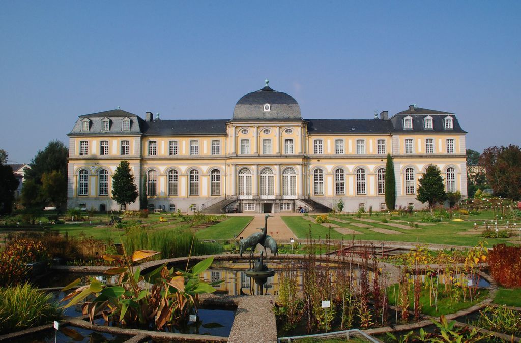
## Description Poppelsdorf Palace Gardens in Bonn offers a quieter, more contemplative travel experience than many people expect from a city stop. The gardens sit beside Poppelsdorf Palace, creating a landscape where formal design, academic history, and botanical interest come together. This is not a flashy amusement-style attraction; it is a place for slow walking, observation, and appreciating the way a historic garden can shape a city experience. For travelers who enjoy architecture and green spaces together, the setting has a calm elegance that is easy to underestimate at first glance. The appeal of the gardens lies in balance. The layout around the palace gives the space a sense of order and historical continuity, while the planting introduces seasonality and change. Depending on when you visit, you may encounter spring blossoms, summer greenery, autumn color, or a quieter winter framework that emphasizes lines and structure. The area feels connected to Bonn’s academic and civic identity, which makes it especially interesting for visitors who want to understand the city through its institutions as well as its monuments. One little-known point is that the surrounding area is tied to the University of Bonn and the wider botanical and scientific traditions of the city. That gives the garden a different character from purely decorative palace grounds. Another detail travelers often appreciate is how peaceful the space can feel even when nearby streets are active. The gardens offer a kind of visual pause, a transition between urban movement and formal green calm. Because the attraction is connected to a palace and university environment, it is also a useful stop for people who enjoy architecture, history, and plant life in one setting. You can admire the building, stroll through the grounds, and then continue into Bonn with a stronger sense of how the city layers its heritage. The result is a destination that feels understated at first but reveals more the longer you stay. ## Location Poppelsdorf Palace Gardens are in Bonn, North Rhine-Westphalia, Germany, within the Poppelsdorf district near the University of Bonn. The location is convenient for travelers already exploring Bonn’s center, because it is reachable from the main urban area without a difficult transfer. Public transport, walking, and cycling are all practical ways to arrive, depending on where you begin. If you are already in central Bonn, walking can be an especially pleasant choice because it lets you approach the gardens gradually and see more of the surrounding district. The area sits comfortably within a wider sightseeing route that might also include the university quarter, museums, and other historic streets. For visitors staying elsewhere in the city, tram or bus connections can make the trip straightforward. ## Tips Visit at a relaxed pace. The gardens are best enjoyed when you are not trying to rush from one photo stop to the next. Sit for a while, study the building and the planting, and let the setting become part of your day rather than a quick pass-through. Use the seasons to your advantage. Spring and early summer are especially rewarding if you enjoy blooms and fresh growth, while autumn can give the grounds a softer, more reflective mood. Even in winter, the geometry of the palace and garden can be appealing if you like architectural landscapes. Pair the visit with other Bonn sights. Because the gardens are part of a larger city context, they work well as a stop between museums, university buildings, or a café break. If you are interested in plant collections or botanic themes, take extra time to notice how the garden’s identity differs from a casual city park. Bring a camera, but also leave room to simply look. The most memorable part of the visit may be the overall calm rather than any single dramatic view. Good shoes, a willingness to walk slowly, and a little curiosity are more useful here than a packed itinerary. ## Conclusion Poppelsdorf Palace Gardens are a graceful and quietly rewarding part of Bonn, combining historic architecture with a restful green setting. They are ideal for travelers who appreciate understated places with depth. ## FAQ ### Are the gardens open to the public? Parts of the grounds are generally accessible as a public green space, but access can vary by area and season. It is sensible to check current information before visiting. ### Do I need to visit the palace itself? No. The gardens can be enjoyed on their own, and many visitors come mainly for the outdoor setting. ### How long should I stay? A short visit may take less than an hour, but a slower walk and nearby exploration can easily fill more time. ### Is this a family-friendly stop? Yes. The space is calm, walkable, and suitable for a relaxed visit with children, provided they are supervised like in any garden environment. ### What is the best time of year to go? Spring and early summer are often the most visually satisfying, but the gardens can be pleasant in any season depending on your interests. ## Links - [Official website](https://www.botgart.uni-bonn.de/en) - [Wikipedia](https://en.wikipedia.org/wiki/Poppelsdorf_Palace)
GemVoyage Team • World
Los Angeles
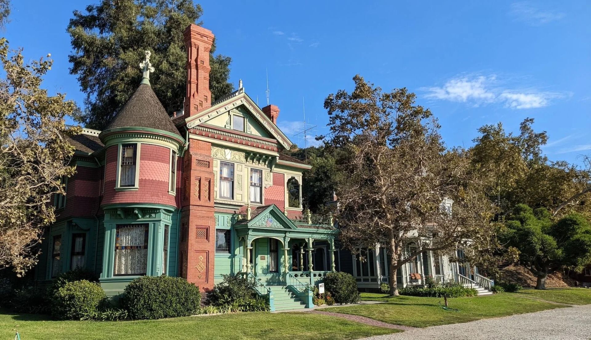
## Description Heritage Square Museum is an extraordinary open-air architectural museum that gathers Victorian and early 20th-century houses and outbuildings within a single historic district to showcase Southern California’s built environment and social history. Each structure has a carefully reconstructed exterior and interpreted interior that reveal the craftsmanship, decorative trends, and daily rhythms of life from a period when Los Angeles was transforming from a frontier town into a burgeoning metropolis. The museum stands out for the authenticity of its fabric: original trim, stained glass, tile, and millwork are preserved or painstakingly restored, and many interiors are furnished with period-appropriate objects to convey domestic stories. Preservation workshops on site keep traditional trades alive—carpentry, plasterwork, and decorative finishes are practiced as living crafts, which both supports ongoing maintenance and educates visitors about restoration techniques. Beyond architecture, Heritage Square interprets social history. Exhibits explore how families lived, worked, and entertained across different socioeconomic strata, and the museum’s programming—guided tours, living history demonstrations, and seasonal festivals—brings these narratives to life. Special events often highlight conservation issues and the ongoing need to protect historic urban fabric in the face of development pressures. For scholars, students, and casual visitors alike, the site offers layered experiences: a close reading of architectural detail, hands-on learning in workshops, and interpretive narratives that connect buildings to broader histories of migration, industry, and urban change. Its role as a rescue repository—structures moved and reassembled to avoid demolition—adds an extra dimension: many buildings carry stories of mid-century urban renewal and community efforts to preserve heritage. ## Location Heritage Square Museum is located in the Montecito Heights neighborhood of Los Angeles, California, a short drive northeast of downtown Los Angeles. The setting—on a hillside with city views—provides a scenic backdrop for exploring an era of American domestic architecture. Getting there: Driving is the most convenient option; limited on-site parking is available. Public transit can be used but often requires transfers and a short walk—check local transit schedules and plan for extra time. Rideshare and local taxis are convenient alternatives. Pair a visit with nearby cultural stops, such as the Huntington Library or local hillside parks, to create a fuller day of exploration. ## Tips - Check the museum’s tour schedule and special-event calendar before you go; guided tours offer the most context and are often led by knowledgeable docents. - Wear comfortable shoes—paths through the outdoor site can be uneven and some properties require short climbs. - Give yourself at least two hours to explore; the combination of interiors, workshops, and outdoor exhibits rewards a relaxed pace. - Bring a camera for exterior architectural photography; observe interior photography rules where posted and respect exhibit boundaries. - If interested in historic trades, inquire about workshop schedules or volunteer opportunities—many preservation skills are demonstrated on site. - Visit in spring or fall for pleasant weather and outdoor events; summer can be warm and winter may bring cooler, wetter days. ## Conclusion Heritage Square Museum preserves an essential chapter of Southern California’s architectural story. By combining rescued structures, conservation workshops, and interpretive programming, it offers a hands-on way to understand historic building crafts and the lives of the people who inhabited these homes. It is an inspiring stop for anyone interested in architecture, preservation, and urban history. ## FAQ Q: Are there guided tours? A: Yes. The museum runs scheduled guided tours and special programs; tours are recommended for first-time visitors to gain historical context and architectural insight. Q: Is the site family-friendly? A: Yes. The museum offers family-oriented programs and activities; children can learn about historic life through interactive demonstrations. Q: Can event spaces be rented? A: Select areas may be rented for private events, though availability and restrictions vary—contact the museum’s events office for details. Q: Are there volunteer opportunities or workshops? A: Yes. The museum often offers volunteer roles, preservation workshops, and demonstrations of traditional trades—check the calendar or volunteer page for current options. Q: Is the site wheelchair accessible? A: Some areas have limited accessibility due to the nature of historic structures and terrain; the museum can provide guidance on accessible routes and accommodations. Q: What’s the best way to learn about restoration techniques demonstrated on site? A: Attend preservation workshops, guided tours that focus on conservation, or scheduled demonstrations—these sessions are designed to explain both craft techniques and the rationale behind repair choices. ## Links - [Heritage Square Museum (official)](https://www.heritagesquare.org) - [Wikipedia: Heritage Square Museum](https://en.wikipedia.org/wiki/Heritage_Square_Museum)
GemVoyage Team • World
Seoul
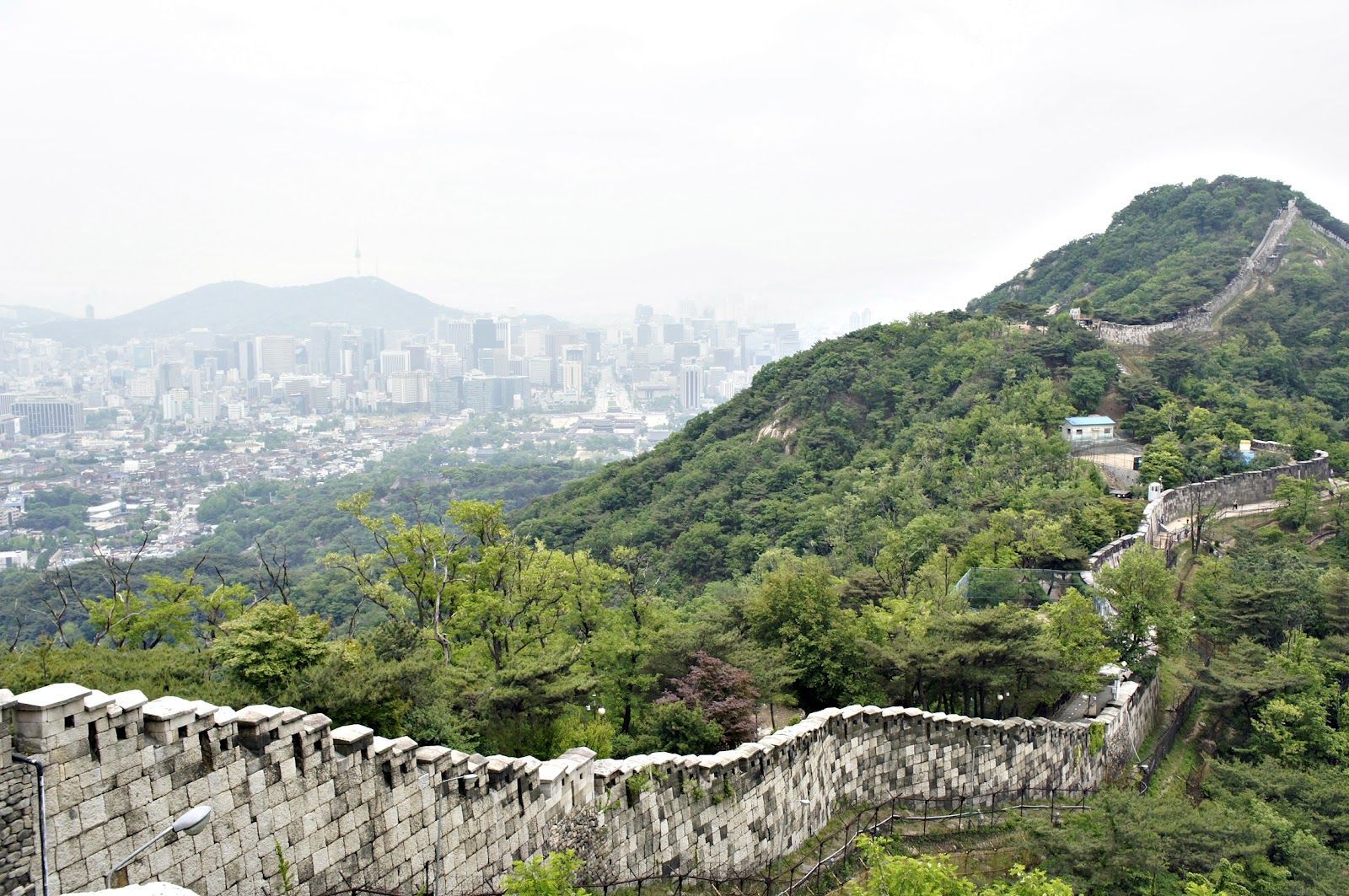
## Description The Seoul Fortress Wall traces the historic boundary of old Seoul, and the Inwangsan section is one of the most compelling short hikes inside the city. Winding stone walls, watchtowers, and narrow ridgelines create a dramatic contrast between rugged natural rock and the modern urban panorama below. Inwangsan (인왕산) itself is a modest peak by elevation, but its steep faces and rocky outcrops make the Fortification route visually striking and surprisingly variable: you pass restored wall segments, crenellated parapets, traditional gates, and quieter stretches where the original stonework blends into pine and ginkgo trees. This route is part walking trail, part living history. Along the Inwangsan section, you can stand at viewpoints that look directly toward Gyeongbokgung Palace and central Seoul, making it a favorite for photographers who want a skyline shot with a distinctly Korean architectural foreground. The combination of natural features and preserved cultural sites gives the trail strong context—archaeologists and local historians point to ritual sites and small petroglyphs on some of the rocky ledges, evidence that the hill has been significant for much longer than the Joseon-era fortifications. For travelers who prioritize accessible day hikes, Inwangsan is practical: the trails are short enough to be combined with a half-day of exploring nearby neighborhoods (Seochon, Buam-dong, or the area around Gyeongbokgung). The experience can feel intimate and unhurried, especially outside popular weekends. For SEO and practical trip planning, search terms that pair well with this route are "Seoul Fortress Wall Inwangsan hike", "Inwangsan panoramic views", and "Seoul city wall trail Gyeongbokgung viewpoint"—phrases locals and travel platforms commonly use. ## Location Inwangsan rises above central Seoul and is most easily accessed on foot from neighborhoods close to Gyeongbokgung Palace and Hyehwa. Nearby subway stations include Gyeongbokgung Station (Line 3) and Hyehwa Station (Line 4); from either point, a 10–25 minute walk brings you to the trailheads depending on your route. Many visitors combine a morning or afternoon at Gyeongbokgung with a short hike up Inwangsan to make efficient use of time. Public transit directions are straightforward: take the subway to Gyeongbokgung or Hyehwa, then follow signs toward the fortress wall trail or ask at local cafes. There are several access points—some are steeper and more direct, others weave through residential lanes and feel more gradual. Maps and local wayfinding often label the path as part of the Seoul City Wall trail network—which helps when using mapping apps or planning a multi-stop day. ## Tips - Hike in the cooler parts of the day: early morning or late afternoon provides the best light for photos and avoids midday crowds and heat. - Wear supportive shoes: some stretches are rocky and uneven; closed-toe hiking shoes or trail runners are recommended. - Bring water and a light snack: although the trail is short, the elevation gain and rocky scrambles benefit from hydration and quick energy. - Be mindful of cultural sites: certain rock ledges and small shrines are used for ritual or prayer—treat them respectfully and avoid disturbing offerings. - Use a map or offline navigation: parts of the trail pass behind residential areas and signage can be minimal; a downloaded map or route screenshot helps. - Combine with nearby visits: pair the hike with a visit to Gyeongbokgung Palace, Seochon’s galleries, or the Buam-dong cafes to make a full half-day itinerary. - Photography tip: for skyline shots with the palace, position yourself on the western-facing viewpoints late in the afternoon for warm light on the stone walls and cool city contrasts. ## Conclusion The Inwangsan section of the Seoul Fortress Wall blends accessible urban hiking with layered history and excellent skyline views. It’s ideally suited for travelers who want a short outdoor escape with high visual return and cultural interest. Whether you pause for a skyline photograph, linger at a watchtower, or simply enjoy the contrast of stone and city, Inwangsan rewards an inquisitive walk and mixes well with central Seoul sightseeing. ## FAQ Q: How long does the Inwangsan trail take? A: Typical loop or ascent routes take 45–90 minutes depending on pace, photo stops, and which trailhead you pick. Q: Is the trail suitable for children or older visitors? A: Many sections are family-friendly, but some parts include short rocky scrambles and steps—evaluate mobility and consider shorter, lower-angle access routes for older visitors. Q: Are parts of the wall restricted or closed at certain times? A: Most sections are open to the public daily, but occasional restoration work or local ceremonies can temporarily limit access—check local signage or community updates. Q: Can I climb on the walls and gates? A: For safety and preservation, avoid climbing on fragile stonework; use designated paths and viewpoints to minimize wear on historic structures. Q: Is there an entrance fee or permit needed? A: No entrance fee—this is a publicly accessible municipal trail and heritage site. ## Links - [Seoul City Wall (Wikipedia)](https://en.wikipedia.org/wiki/Seoul_City_Wall)
GemVoyage Team • World

Comments