GemVoyage Team • World
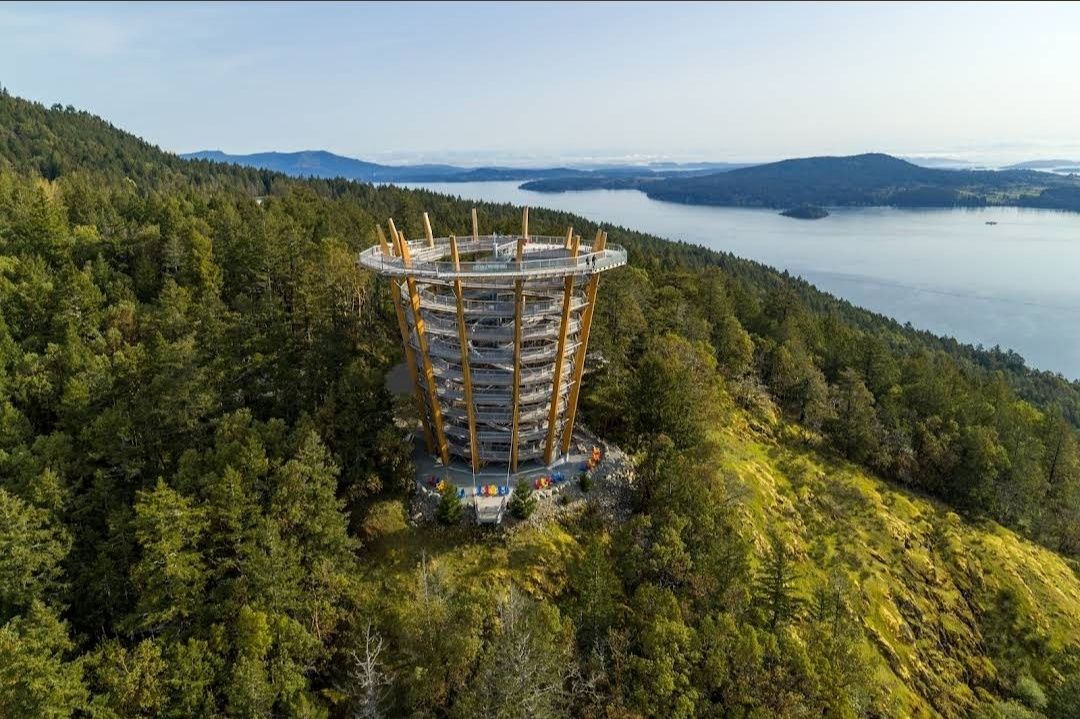
The Malahat SkyWalk Spiral Tower is one of Canada’s most spectacular outdoor attractions, offering visitors an unforgettable way to experience the natural beauty of Vancouver Island. This unique tower features a gently sloping spiral ramp that winds its way upward for over 600 meters, leading to a stunning 250-meter elevated walkway through the treetops. At the very top, visitors are rewarded with 360-degree panoramic views of the Saanich Peninsula, the Gulf Islands, Mount Baker in Washington State, and even glimpses of the Coast Mountains.
What makes this destination truly remarkable is its architectural design that blends seamlessly into nature. The tower is constructed primarily from locally sourced Douglas fir and steel, combining eco-friendly practices with modern engineering. Unlike traditional observation decks, the spiral walkway makes it fully accessible to people of all ages and mobility levels.
A little-known fact about the Malahat Spiral Tower is the adventure net—a giant webbed net suspended high above the ground at the tower’s summit. Brave visitors can step onto it and look straight down through the open center of the tower for a thrilling perspective. Another hidden gem is the 45-meter-long spiral slide that winds its way down the inside of the tower, offering kids and adults alike an exciting alternative to walking back down.
The Malahat SkyWalk Spiral Tower is located on southern Vancouver Island, British Columbia, Canada, about 35 kilometers (roughly 40 minutes) north of Victoria, the provincial capital. It sits along the Malahat Highway (Highway 1), a scenic route known for its breathtaking coastal views and winding mountain roads.
The attraction is easily accessible by car, making it a popular day trip from Victoria. Visitors traveling from Vancouver can reach it by taking a ferry to Swartz Bay and then driving south toward Victoria before heading north on the Malahat Highway. For those without a car, guided tours from Victoria are also available and often include other nearby highlights.
Recommendation: If possible, plan your visit in the morning to avoid crowds and enjoy the crisp air and soft lighting, which make the views even more magical.
To make the most out of your visit to the Malahat Spiral Tower, here are some helpful tips:
The Malahat SkyWalk Spiral Tower isn’t just an observation deck—it’s a full sensory experience that blends nature, adventure, and breathtaking views. From the treetop walkway to the thrill of the spiral slide and the panoramic views of land and sea, it offers something for everyone. Whether you’re a nature lover, a family traveler, or simply looking for an unforgettable outing near Victoria, this attraction deserves a spot on your bucket list.
1. How long does it take to visit the Malahat SkyWalk Spiral Tower?
Most visitors spend between 1.5 to 2 hours exploring the treetop walkway, climbing the spiral tower, and enjoying the views.
2. Is the Malahat SkyWalk open year-round?
Yes, it’s open in all seasons, though hours may vary. Each season offers a different experience—from lush green summers to snow-dusted winter landscapes.
3. Is the Malahat SkyWalk suitable for kids?
Absolutely! Children love the slide, and the walkway is stroller-friendly, making it a perfect family activity.
4. Can I bring my dog to the Malahat SkyWalk?
Yes, dogs on leashes are welcome along the treetop walk and the spiral tower, though they’re not allowed on the slide.
5. Is the attraction wheelchair accessible?
Yes, the entire pathway and spiral ramp are designed to be fully accessible for wheelchairs and strollers.
For more information, tickets, and updates, visit these official and helpful resources:
Discover more hidden gems you might love.

Hong Kong
## Description Nan Lian Garden is one of Hong Kong’s most beautiful and tranquil urban escapes. Designed in the style of a classical Chinese garden, it offers a carefully balanced landscape of ponds, pavilions, bridges, rocks, timber structures, and manicured plantings. In a city known for density and energy, the garden creates a sense of quiet that feels almost protective. For travelers who want a break from markets, towers, and busy streets, this is an ideal place to slow down. The garden stands out because every part of it feels intentional. Paths curve in a way that reveals views gradually, water is placed to reflect architecture and sky, and the plant life is arranged to create a sense of harmony rather than display. It is not a large theme park style attraction; instead, it rewards observation and a slower pace. Visitors often leave surprised by how much visual richness can be packed into a relatively compact space without feeling crowded. One little-known fact is that Nan Lian Garden was designed to echo the aesthetics of the Tang dynasty, which means the landscape is guided by historical artistic principles rather than modern ornamental trends. Another detail many people miss is the garden’s ability to change character with the weather. On a bright day, the orange, red, and green tones look crisp and vivid. On a misty or overcast day, the place becomes softer and more contemplative, almost like a living painting. The nearby cultural surroundings also add depth to the visit. Many travelers pair the garden with adjacent spiritual and architectural sites because the whole area encourages a thoughtful pace. Even if you only have a short time, the garden can leave a strong impression because it feels so different from the surrounding city. It is carefully maintained but not sterile, elegant but not intimidating, and peaceful without feeling empty. Another reason the garden is memorable is that it offers a very photogenic composition without requiring any special effort. Reflections, stonework, and traditional roofs create good images from many angles. Still, the real value of the place is not just visual. It is the emotional contrast between the garden and the rest of Hong Kong. That contrast is what makes the visit feel restorative. ## Location Nan Lian Garden is located in Diamond Hill, Kowloon, Hong Kong. It is part of a cultural area in the eastern side of Kowloon and is closely associated with traditional architecture and landscaped public space. The most convenient access is usually through Diamond Hill MTR Station, followed by a short walk from the station into the garden area. Because the garden is centrally accessible by public transport, it fits easily into a Hong Kong itinerary. You do not need a special transfer or long taxi ride to get there. If you are already in Kowloon, it is especially easy to combine with nearby neighborhoods or with other cultural stops in the same district. Arriving by MTR is generally the simplest and most efficient option. ## Tips - Visit in the morning for a quieter atmosphere and better light. - Move slowly and take time to notice the composition of the paths, water, and buildings. - Dress comfortably, but respectfully, since the area has a calm and somewhat formal mood. - Combine the visit with nearby cultural sites so the trip feels complete. - Bring a camera, but do not rush the experience just to get photos. ## Conclusion Nan Lian Garden is one of Hong Kong’s best places for calm, balance, and classical beauty in the middle of a fast-moving city. ## FAQ ### Is Nan Lian Garden free to visit? Access policies can vary, so it is best to check current conditions before going, but the garden is widely known as a very accessible public attraction. ### How much time do I need there? Most visitors spend 45 minutes to 2 hours depending on whether they also visit nearby attractions. ### Is it suitable for children? Yes. The garden is peaceful and easy to walk through, so it can work well for families. ### What makes it different from other Hong Kong attractions? Its classical design and calm atmosphere set it apart from the city’s more modern, commercial, and high-energy destinations. ### What is the best time to go? Morning is usually best because the garden is quieter and the light is more flattering for photos. ## Links - [Wikipedia article](https://en.wikipedia.org/wiki/Nan_Lian_Garden)
GemVoyage Team • World
Stockholm
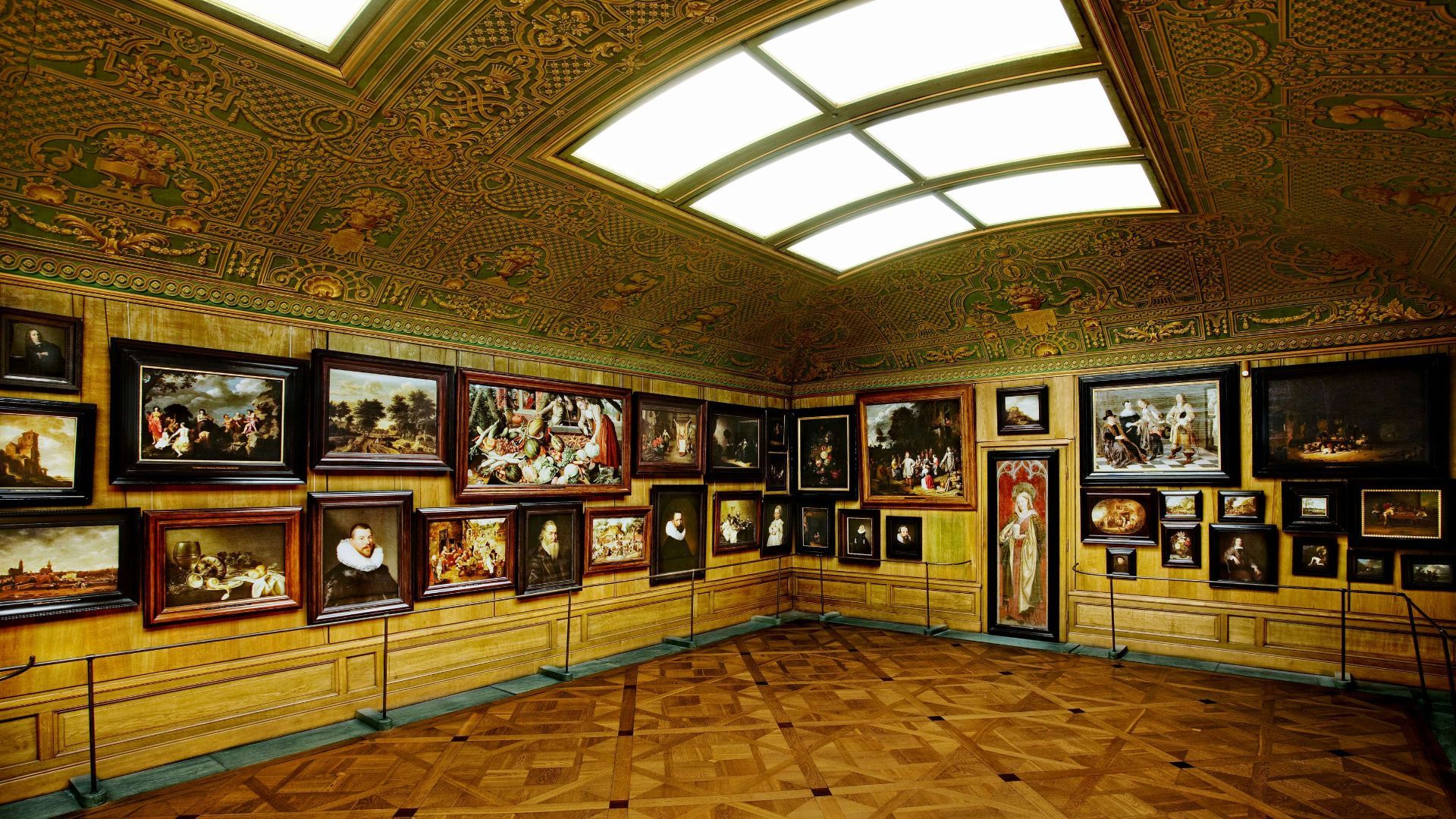
## Description The Hallwyl Museum in Stockholm offers one of the city’s most distinctive historic-house experiences. Housed in the former residence of Count and Countess von Hallwyl, the museum preserves an extraordinary late-nineteenth-century interior filled with art, furniture, decorative objects, and the feeling of a private home that has been carefully maintained rather than transformed into a generic museum. Visiting it is like stepping into a remarkably complete snapshot of upper-class domestic life in Stockholm at the turn of the century. The museum is especially appealing because it balances grandeur and intimacy. Some rooms are richly decorated and formal, while others feel like lived-in domestic spaces, making the whole building feel coherent rather than staged. One little-known fact is that the Hallwyl collection was assembled with unusual care and documentation, giving historians and visitors a detailed view of the household’s contents and routines. Another interesting detail is that the house itself reflects both status and modernity, showing how wealthy Stockholm families adopted new technologies and comforts while still displaying traditional elegance. What makes the museum memorable is the combination of its architecture, interiors, and sense of personal history. Unlike larger national museums, Hallwyl’s charm comes from concentration. Every room, object, and corridor contributes to a specific atmosphere. The visit is ideal for travelers who enjoy historic interiors, design history, or the way private homes can reveal broader social changes. It also fits well into Stockholm’s cultural landscape because it offers a different experience from the city’s more famous royal or maritime attractions. Instead of scale, it offers detail; instead of spectacle, it offers texture. ## Location The Hallwyl Museum is in central Stockholm, Sweden, near the city’s commercial and cultural core. Its location makes it easy to reach from many parts of the city and convenient to combine with shopping streets, other museums, or a broader downtown walk. The simplest way to get there is by public transport or on foot from central Stockholm. Because the city is well connected, visitors staying in the center can usually reach the museum quickly without needing a car. If you are planning a full day in central Stockholm, the museum works well as a quieter stop between busier attractions. ## Tips Take your time in the rooms; the best part of the museum is noticing the details. If you enjoy decorative arts, interiors, or social history, this museum will be especially rewarding. Check the current opening information in advance, since historic-house museums sometimes have schedule variations. Pair the visit with nearby Stockholm attractions to make the most of the central location. ## Conclusion The Hallwyl Museum is a refined and atmospheric historic house that gives visitors a rare, detailed glimpse into Stockholm’s aristocratic past. ## FAQ ### What kind of museum is Hallwyl? It is a historic house museum preserved from a wealthy Stockholm family’s residence. ### Is it good for first-time visitors to Stockholm? Yes, especially if you want a cultural site that is elegant and manageable in size. ### How long should I plan for the visit? Around one to two hours is usually enough. ### Is the museum family-friendly? Yes, though it is especially enjoyable for visitors interested in history and interiors. ### Why is it special compared with other museums? Because it preserves a remarkably complete domestic environment rather than only displaying isolated objects. ## Links - [Official website](https://hallwylskamuseet.se/en/) - [Hallwyl Museum on Wikipedia](https://en.wikipedia.org/wiki/Hallwyl_Museum)
GemVoyage Team • World

Copenhagen
## Description The **Gefion Fountain (Gefionspringvandet)** is one of **Copenhagen’s most iconic landmarks**, combining stunning sculpture, mythological symbolism, and the serene beauty of its waterfront setting. Unveiled in **1908**, the fountain depicts the **Norse goddess Gefion**, a figure from ancient Scandinavian mythology, driving a group of **powerful oxen** as they pull the land that became the island of **Zealand (Sjælland)** — where Copenhagen stands today — from the depths of the sea. Designed by **Danish sculptor Anders Bundgaard**, the fountain is both a **monumental work of art** and a **celebration of Danish legend and identity**. The dynamic bronze figures, set atop a granite basin, capture the dramatic moment of transformation: Gefion’s oxen straining against their harnesses, water surging around them, and the goddess commanding them with divine strength. The story behind the sculpture comes from **Norse mythology**, where Gefion tricks the Swedish king **Gylfi** into granting her as much land as she can plow in one night. Transforming her four sons into oxen, she plows through the earth and casts the land into the sea — forming the island of Zealand. The resulting lake in Sweden, **Lake Vänern**, is said to match Zealand’s shape. What makes the Gefion Fountain unique is not only its **artistic detail and mythological depth** but also its **location** — it sits between **Kastellet Fortress** and **Langelinie Promenade**, surrounded by lush greenery and views of the **harbor** and **The Little Mermaid statue** nearby. The fountain is especially magical when illuminated at night, with the flowing water and shimmering bronze giving it an ethereal glow. A lesser-known fact is that the fountain was originally commissioned by the **Carlsberg Foundation** to celebrate the brewery’s 50th anniversary and was gifted to the city of Copenhagen. Another interesting detail: the granite blocks forming the base came from **Sweden**, a subtle nod to the myth that connects the two lands. ## Location The **Gefion Fountain** is located in **Churchillparken (Churchill Park)** near **Langelinie**, in the **central harbor area of Copenhagen**, **Denmark**. It sits just east of **Amalienborg Palace** and north of the **Kastellet (The Citadel)** fortress. To get there: * **By metro:** Take the **M3 (City Circle Line)** to **Marmorkirken Station**, then walk about **10 minutes** northeast toward the harbor. * **By bus:** Several local buses, including routes **26** and **27**, stop nearby at **Esplanaden**. * **By foot or bike:** The fountain is part of a popular **walking and cycling route** that connects **Amalienborg**, **The Little Mermaid**, and **Kastellet**. * **By car:** Limited parking is available nearby, though walking or cycling is more convenient in this area. ## Tips * **Visit in the morning or late evening:** The light at sunrise and sunset enhances the sculpture’s bronze tones and reflections. * **Combine with nearby landmarks:** The **Little Mermaid**, **Kastellet Fortress**, and **Amalienborg Palace** are all within walking distance. * **Evening illumination:** Visit after dark to see the fountain beautifully lit — a favorite spot for photographers. * **Learn the mythology:** Understanding the legend of Gefion adds depth to your visit; many plaques around the site explain the story. * **Bring a camera:** The fountain’s movement, water effects, and sculptural detail make it a fantastic subject for photos. * **Relax nearby:** The surrounding park offers benches and green spaces perfect for a quiet break during a city walk. * **Visit year-round:** While the fountain operates mainly in warmer months, the sculptures remain accessible and impressive throughout the year. ## Conclusion The **Gefion Fountain** is much more than a beautiful monument — it’s a vivid connection between Denmark’s ancient mythology and its modern identity. With its stunning artistry, powerful symbolism, and scenic harbor location, it perfectly embodies Copenhagen’s blend of **history, legend, and elegance**. Whether you’re tracing the city’s cultural landmarks, enjoying a peaceful stroll through Churchill Park, or exploring Norse mythology, the Gefion Fountain offers a moment of reflection and wonder that captures the timeless spirit of Denmark. ## FAQ **1. What does the Gefion Fountain represent?** It depicts the Norse goddess **Gefion** plowing the land that became the island of **Zealand (Sjælland)**, symbolizing the creation of Denmark’s largest island. **2. Who designed the fountain?** The fountain was created by **Anders Bundgaard**, one of Denmark’s most celebrated sculptors, and unveiled in **1908**. **3. Where is the Gefion Fountain located?** In **Churchillparken**, near **Langelinie Promenade** and **Kastellet Fortress**, in central **Copenhagen**, Denmark. **4. Is it near other attractions?** Yes — it’s just a short walk from **The Little Mermaid**, **Amalienborg Palace**, and the **harborfront**. **5. When does the fountain operate?** The fountain usually runs from **April to October**, depending on weather conditions. The sculptures can be viewed year-round. **6. Is there an entrance fee?** No — visiting the Gefion Fountain is **free of charge**. **7. Can I visit at night?** Yes, and it’s highly recommended. The **evening lighting** creates a beautiful, almost mythical atmosphere. ## Links * [Official Visit Copenhagen – Gefion Fountain](https://www.visitcopenhagen.com/)
GemVoyage Team • World

Ontario
## Description The Tobermory Grotto is one of Ontario’s most recognizable natural attractions and a place that has become almost legendary among travelers who love clear water, rocky shoreline, and dramatic coastal scenery. Located along the Bruce Peninsula in Bruce Peninsula National Park, the Grotto is a sea cave and shoreline formation shaped by water and stone over a very long stretch of time. Its appeal is immediate: bright turquoise water, pale limestone cliffs, and a setting that looks more like a distant island destination than a typical inland Canadian getaway. What makes the Grotto so memorable is how strongly it contrasts with expectation. Travelers who arrive expecting a simple viewpoint often discover a landscape that feels startlingly vivid. The water color can seem almost unreal when sunlight is strong, and the surrounding rock formations create a natural frame that feels tailor-made for photography. Beyond the famous cave itself, the broader Bruce Peninsula landscape adds to the experience with forest, shoreline trails, and a sense of remote beauty that is unusually accessible for southern Ontario. One little-known fact is that the Grotto’s appearance changes dramatically with weather and light. On bright days, the water can look intensely blue-green, while overcast conditions make the scene quieter and more subdued. Another detail visitors often discover only when they arrive is that the site’s popularity has changed how it must be visited. Timing, access planning, and park rules matter more than they do at many ordinary day-use destinations. That is not a drawback so much as part of the modern experience of seeing one of Canada’s most celebrated natural spots. The Grotto is also a place that rewards patience. People often talk about it as a photo stop, but the longer you stay in the region, the more complete the experience becomes. The surrounding national park, the shoreline walk, and the broader Tobermory area all help the destination feel like a true outdoor trip rather than a single scenic moment. ## Location The Tobermory Grotto is in Bruce Peninsula National Park near Tobermory, Ontario, on the western side of the Bruce Peninsula along Georgian Bay. Tobermory is a small but well-known community at the northern end of the peninsula, and the Grotto is reached from there by road and park access rather than by urban transit. For most visitors, driving is the standard and most practical way to get there. Because the Grotto is a popular destination with limited access and park management considerations, it is wise to plan ahead rather than assuming you can simply arrive at any time. If you are coming from Toronto, London, or other parts of southern Ontario, the trip is long enough that an overnight stay in the Tobermory area can make the visit far more enjoyable. That also gives you time to explore the park properly instead of rushing in and out around the single most famous viewpoint. ## Tips Book and plan early. This is not the kind of place where improvisation always works best, especially in busy season. Parking, access rules, and timing can shape your experience significantly. If you wait until the last minute, you may find your options limited. Bring sturdy shoes and be prepared for a walk. The Grotto is scenic, but reaching it typically requires more effort than a simple roadside stop. The terrain can be rocky and uneven, so footwear matters. If you plan to swim, remember that natural water is cold even on warm days, and conditions can be less forgiving than they look from a photo. Think beyond the cave itself. The Grotto is the headline, but the whole Bruce Peninsula area is worth time. Nearby trails, shoreline views, and the general Tobermory landscape help transform the trip from a single stop into a richer outing. If possible, stay long enough to enjoy the area during different light conditions. Watch the weather. Clear sky and sunlight can make the water look especially bright, but even cloudy days have their own moody beauty. Safety, however, always matters more than the photo. Check local guidance before entering the water or walking near exposed edges. ## Conclusion The Tobermory Grotto is one of Ontario’s most impressive natural sights, blending dramatic shoreline scenery with the iconic turquoise water of Georgian Bay. It deserves the planning it requires and rewards travelers who make time for the wider peninsula. ## FAQ ### Is the Grotto worth the trip from Toronto? Yes, especially if you enjoy dramatic natural scenery and do not mind a longer drive. Many visitors treat it as an overnight or weekend trip so they can enjoy the Bruce Peninsula more fully. ### Can I swim there? Swimming may be possible depending on conditions and local rules, but the water is very cold and natural shoreline conditions can be challenging. Always check current guidance before entering the water. ### Do I need to visit in summer? Summer is the most popular season, but the area can be beautiful at other times too. The tradeoff is that access, weather, and comfort levels vary by season. ### Is the Grotto suitable for children? It can be, if you are careful and supervise closely. The rocky terrain means families should pay attention to footing and safety. ### How much time should I plan? At minimum, allow enough time for the walk, the viewpoint, and the return. A fuller Bruce Peninsula day trip is much more satisfying than a rushed photo stop. ## Links - [Official website](https://parks.canada.ca/pn-np/on/bruce/activ/experiences/grotto) - [Wikipedia](https://en.wikipedia.org/wiki/Bruce_Peninsula_National_Park)
GemVoyage Team • World

Los Angeles
## Description Smorgasburg Los Angeles is one of the city’s most vibrant and eclectic open-air food markets, drawing in foodies, families, and curious visitors every Sunday. What started as a popular market in Brooklyn, New York, has successfully expanded to Los Angeles, where it has taken on its own West Coast identity. The market brings together **dozens of vendors** offering everything from Korean barbecue tacos to vegan donuts, lobster rolls, artisanal coffee, and even experimental food trends that often go viral on social media. What makes Smorgasburg LA unique is not only the incredible variety of food but also its **community-centered atmosphere**. Beyond food, the market also features small retail vendors selling local crafts, clothing, home goods, and artwork. It’s as much a cultural gathering spot as it is a food haven. A little-known fact is that Smorgasburg LA is located on the site of the **old Alameda Produce Market**, connecting today’s modern street food scene with the historic roots of Los Angeles’ food distribution hub. Another fun detail is that the market regularly hosts **pop-up events and chef collaborations**, meaning visitors can often find exclusive dishes available for a limited time. ## Location Smorgasburg Los Angeles is located in the **United States, California, Los Angeles**, specifically in the **ROW DTLA (Downtown Los Angeles)** complex. Its address is **777 S. Alameda Street, Los Angeles, CA 90021**, making it conveniently situated near the Arts District and Little Tokyo. ### Recommendation on How to Get There The easiest way to reach Smorgasburg is by **car**, as it offers a large parking structure with several hours of free parking for market visitors. However, for those who prefer not to drive, public transportation is also an option—the market is accessible via the **Metro Gold Line (Little Tokyo/Arts District Station)**, followed by a short walk. Ridesharing services such as Uber and Lyft are also widely available and recommended if you plan on enjoying craft beers or cocktails at the market. ## Tips Here are some helpful tips for making the most out of your Smorgasburg LA visit: * **Arrive Early**: Popular vendors often have long lines, and some specialty dishes sell out quickly. * **Bring Friends**: Sharing dishes allows you to sample a wider variety of foods without getting too full. * **Bring Cash and Cards**: Most vendors accept cards, but having some cash on hand can speed things up. * **Check the Schedule**: Some vendors rotate weekly, and there are often special events or limited-time pop-ups. * **Wear Comfortable Clothing**: Since the market is outdoors, dress for the weather and wear comfortable shoes. * **Stay Hydrated**: Los Angeles can get hot, so grab drinks from one of the fresh juice or craft soda stalls. * **Don’t Skip the Retail Vendors**: Beyond food, you’ll find unique handmade goods, vintage items, and local art. ## Conclusion Smorgasburg Los Angeles is more than just a food market—it’s an experience that captures the city’s creative energy and love of diverse cuisines. With its wide selection of vendors, lively atmosphere, and mix of food, retail, and entertainment, it’s the perfect Sunday destination in Downtown LA. Whether you’re a local foodie or a visitor exploring the city, Smorgasburg LA offers a taste of Los Angeles’ culinary innovation at its best. ## FAQ **1. What day is Smorgasburg LA open?** Smorgasburg Los Angeles is open every **Sunday from 10 AM to 4 PM**. **2. How much does it cost to enter the market?** Entry is **free**, but you’ll need to pay for food, drinks, and any retail items you purchase. **3. Is there parking available?** Yes, the market offers **several hours of free parking** at the ROW DTLA parking structure for visitors. **4. Are there vegetarian or vegan options?** Absolutely—many vendors specialize in vegetarian, vegan, and gluten-free dishes. **5. Can I bring my kids or pets?** Yes, the market is **family-friendly**, and pets are also welcome, making it a great outing for the whole family. **6. Are the vendors always the same?** Some vendors are permanent, but many rotate, and there are frequent pop-up collaborations, so you’ll often find new foods to try. ## Links * [Official Smorgasburg Los Angeles Website](https://la.smorgasburg.com/)
GemVoyage Team • World

Izmir
## Description Izmir Wildlife Park (İzmir Doğal Yaşam Parkı) is one of Turkey’s most impressive and thoughtfully designed animal parks, offering a refreshing blend of conservation, education, and recreation. Opened in 2008 by the Izmir Metropolitan Municipality, the park was created as a modern alternative to the old Izmir Zoo, with a strong emphasis on animal welfare and natural habitats. Today, it spans over 425,000 square meters and is home to nearly 1,800 animals from 132 different species. What sets Izmir Wildlife Park apart is its commitment to creating spacious, naturalistic enclosures that mimic the animals’ native environments. Visitors can stroll through themed zones such as the African Savannah, Monkey Islands, Birds of Prey section, and the Tropical Center—the first of its kind in Turkey. The park also features a large pond for waterfowl and a charming Children’s Zoo where kids can interact with friendly farm animals. A little-known fact: the park was awarded by the Organization of Islamic Capitals and Cities (OICC) in 2013 for excellence in municipal services, landscape, and environmental design. Another hidden gem is the Tropical Center, which houses exotic species like macaws, marmosets, fruit bats, and crocodiles in a climate-controlled environment that replicates rainforest conditions. ## Location Izmir Wildlife Park is located in **Turkey**, in the **Aegean Region**, within the city of **Izmir**, specifically in the **Çiğli district**. It’s situated in the Sasalı neighborhood, a peaceful area surrounded by nature and away from the city’s hustle. ### How to Get There: - **By Public Transport**: From central Izmir, take the İZBAN commuter train to Çiğli Station, then transfer to bus number 751 or 777 toward Sasalı. - **By Car**: The park is about a 30-minute drive from downtown Izmir. Free parking is available on-site. - **By Tour**: Some local tour operators include the park in family-friendly itineraries, often paired with nearby attractions like the Bird Paradise (Kuş Cenneti). Its accessibility and tranquil setting make it an ideal day trip for families, nature lovers, and curious travelers. ## Tips for Visitors To make the most of your visit to Izmir Wildlife Park, keep these tips in mind: - **Arrive Early**: The park opens at 9:00 AM and closes at 6:30 PM. Early visits offer cooler temperatures and more active animals. - **Wear Comfortable Shoes**: The park is vast and designed for walking. Expect to spend 2–3 hours exploring. - **Bring Snacks and Water**: While there are cafes and kiosks, bringing your own refreshments can be handy, especially for kids. - **Check for Events**: The park occasionally hosts educational workshops and seasonal events—check the schedule before you go. - **Respect the Animals**: Feeding is prohibited, and loud noises can disturb the animals. Be mindful and enjoy observing them in peace. - **Visit on Weekdays**: Weekends can be crowded. A weekday visit ensures a quieter, more relaxed experience. ## Conclusion Izmir Wildlife Park is a beautifully curated sanctuary that blends education, conservation, and leisure. With its diverse animal collection, spacious habitats, and family-friendly atmosphere, it’s a standout destination in Turkey’s Aegean region. Whether you're traveling solo or with kids, this park offers a memorable and meaningful encounter with wildlife. ## FAQ **1. What are the opening hours of Izmir Wildlife Park?** The park is open daily from 9:00 AM to 6:30 PM, except Mondays when it’s closed for maintenance. **2. Is there an entrance fee?** Yes, but it’s very affordable. Ticket prices are modest, making it accessible for all visitors. **3. Can I bring food into the park?** Yes, you can bring your own snacks and water, though there are also cafes and kiosks available. **4. Is the park suitable for children?** Absolutely. The Children’s Zoo and interactive exhibits make it a great destination for families. **5. Are guided tours available?** While self-guided visits are common, some educational programs and group tours can be arranged in advance. **6. Is the park wheelchair accessible?** Yes, most paths are accessible, and facilities are designed to accommodate visitors with mobility needs. ## Links - [Izmir Wildlife Park – Official Website](https://www.izmirdogalyasamparki.org.tr/en/home) - [Izmir Wildlife Park – Wikipedia](https://en.wikipedia.org/wiki/%C4%B0zmir_Wildlife_Park)
GemVoyage Team • World

Comments