GemVoyage Team • World
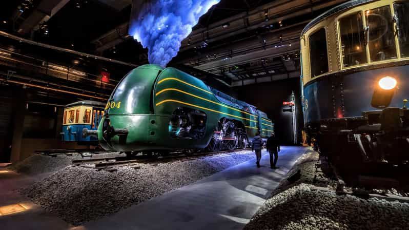
What makes Train World especially strong is how it balances spectacle and interpretation. You are not simply looking at engines behind barriers. You move through environments that explain the role of rail in Belgian life, the evolution of travel, and the aesthetics of the railway age. A lesser-known fact is that the museum occupies an architectural setting of real importance, since the station itself contributes to the atmosphere and historical context. Another detail many visitors find interesting is the way the museum uses lighting, layout, and display composition to make trains feel almost theatrical, which helps even casual visitors appreciate the engineering and cultural significance behind them.
The collection includes both historic rolling stock and broader narratives about mobility, labor, and national development. That means the museum is not just about machines; it is about how railways reshaped cities, connected regions, and changed the way people moved through Europe. In Belgium, a country with a dense rail network and a deep industrial past, that story matters. Train World captures it in a way that feels serious without becoming dry.
The museum also works well as a family stop because it offers enough visual drama to keep children interested while still rewarding adults who want historical context. It is one of those places where the experience is stronger than you may expect from the outside.
The easiest way to reach Train World is by train, tram, or other public transport from central Brussels. Because it is a railway museum in a real railway station, arriving by rail is especially fitting and often the most straightforward option. Once you arrive, the museum is easy to navigate, and the surrounding area is manageable for a combined transport-and-history outing.
It is a good idea to set aside enough time to move through the whole exhibition at a relaxed pace. The museum is richer when you let the sequence unfold naturally rather than rushing straight to the largest locomotives.
Go with children or transport enthusiasts if you can, but do not assume it is only for specialists. The presentation is strong enough for general visitors.
Pay attention to the station architecture as well as the trains. The setting is part of the story.
Check opening times in advance, especially if you are building it into a broader Brussels itinerary.
If you enjoy design, photography, or industrial history, spend extra time with the details rather than rushing between the biggest exhibits.
Discover more hidden gems you might love.
Cairo
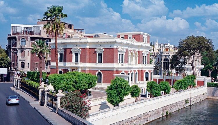
## Description **Aisha Fahmy Palace** is one of Cairo’s most elegant examples of early 20th-century aristocratic architecture and a rare survivor of the city’s Belle Époque period. Built in **1907**, the palace reflects a time when Cairo’s elite embraced European artistic influences while maintaining a distinct Egyptian identity. Today, it stands not as a frozen relic, but as a carefully restored cultural venue that bridges past luxury with contemporary artistic expression. The palace was commissioned by Ali Fahmy Pasha and later inherited by his daughter, Aisha Fahmy, whose name it still carries. Designed by Italian architect Antonio Lasciac, the building combines **Italian Renaissance influences with Art Nouveau and neoclassical details**. Marble staircases, ornate ironwork, stained glass windows, and elaborately decorated ceilings reveal the level of craftsmanship invested in elite residential architecture at the time. What makes Aisha Fahmy Palace particularly compelling is its **interior artistry**. The walls and ceilings feature painted panels inspired by classical European mythology, floral motifs, and allegorical scenes, many of which were executed by European artists working in Cairo. A lesser-known fact is that the palace once hosted private salons and cultural gatherings attended by prominent figures from Egypt’s political and artistic circles. Another overlooked detail is that, despite periods of neglect during the late 20th century, much of the original decorative work survived and was meticulously restored rather than replaced. Today, the palace functions as a **temporary exhibition space** under the Egyptian Ministry of Culture. Contemporary art exhibitions are staged within the historic rooms, creating a deliberate contrast between modern creative expression and early 1900s aristocratic interiors. This dialogue between eras is central to the palace’s renewed relevance. ## Location **Country:** Egypt **Governorate:** Cairo **District:** Zamalek Aisha Fahmy Palace is located in **Zamalek**, one of Cairo’s most refined and leafy neighborhoods, situated on Gezira Island in the Nile. ### How to Get There * **By taxi or ride-hailing:** * The most practical option, especially from central Cairo or downtown. * **By metro:** * Take Line 2 to **Opera Station**, then walk or take a short taxi ride. * **On foot:** * Easily reachable when exploring Zamalek’s cultural venues and riverfront. * **By car:** * Limited street parking is available in the surrounding area. ## Tips * **Check exhibition schedules in advance:** The palace hosts rotating exhibitions rather than permanent displays. * **Allow time to explore interiors:** The architectural details are as important as the artworks. * **Visit during daylight hours:** Natural light enhances the painted ceilings and stained glass. * **Photography rules vary:** Some exhibitions may restrict interior photography. * **Combine with nearby sites:** Zamalek offers galleries, cafés, and cultural centers within walking distance. * **Expect calm rather than crowds:** The palace remains relatively uncrowded compared to major museums. ## Conclusion Aisha Fahmy Palace is a refined cultural landmark that captures a sophisticated chapter of Cairo’s modern history. Its restored interiors, aristocratic architecture, and evolving role as an art space make it a rewarding destination for visitors seeking depth, elegance, and context beyond the city’s ancient monuments. ## FAQ **1. Is Aisha Fahmy Palace a museum?** It functions primarily as a temporary exhibition venue rather than a traditional museum. **2. How old is the palace?** It was completed in 1907. **3. How long should I plan for a visit?** Approximately **45 minutes to 1.5 hours**, depending on exhibitions. **4. Is there an entrance fee?** Yes, a modest fee is usually charged and may vary by exhibition. **5. Is the palace suitable for children?** Yes, particularly for older children interested in art or architecture. **6. Is the palace accessible?** Accessibility is limited in some areas due to the historic structure. ## Links * [Experience Egypt tourism portal](https://www.experienceegypt.eg)
GemVoyage Team • World
.jpg)
Chongqing
## Description Jiefangbei Shopping Street, also known as **Jiefangbei Pedestrian Street**, is one of the most famous commercial districts in China and the beating heart of **Chongqing**. This bustling area is not just a shopping paradise but also a cultural and social hub, attracting millions of visitors every year. It combines luxury boutiques, international brands, local shops, trendy cafés, and street food stalls—all wrapped in the energetic atmosphere of one of China’s fastest-growing cities. At the center of the district stands the **Jiefangbei Monument (Liberation Monument)**, a historic landmark originally built in 1945 to commemorate China’s victory in World War II. Over time, the monument became surrounded by skyscrapers, neon lights, and high-end malls, symbolizing Chongqing’s transformation from a wartime city into a modern metropolis. A little-known fact is that Jiefangbei Shopping Street is often referred to as the **“Times Square of Chongqing”** due to its massive LED screens, vibrant nightlife, and crowds of visitors. Another unique detail is that beneath the pedestrian street lies a **complex underground shopping mall**, where visitors can explore an entire network of shops, restaurants, and entertainment venues. ## Location Jiefangbei Shopping Street is located in the **Yuzhong District of Chongqing, China**, right in the heart of the city’s central business area. Its central location makes it not only a shopping hotspot but also a starting point for exploring Chongqing’s rich culture and modern lifestyle. ### Recommendation on How to Get There The easiest way to reach Jiefangbei is by **metro**. Take **Line 2 or Line 6** of the Chongqing Metro and get off at **Xiaoshizi Station** or **Jiaochangkou Station**, both of which are just a short walk from the monument. Taxis are also widely available, but due to traffic congestion in the area, the metro is often faster and more convenient. For those staying in central hotels, the street is within easy walking distance. ## Tips Here are some useful tips to make the most of your visit to Jiefangbei Shopping Street: * **Shop Smart**: You’ll find everything from international luxury brands to local fashion boutiques. Bargaining is not common in malls but may be possible at smaller shops or street stalls. * **Try the Food**: Don’t miss the chance to taste Chongqing’s famous **spicy hotpot** or sample local street snacks like grilled skewers and spicy noodles. * **Visit at Night**: The area is most impressive in the evening when the neon lights illuminate the skyscrapers and the monument. * **Wear Comfortable Shoes**: The pedestrian street is large, and exploring the underground shopping centers can involve a lot of walking. * **Combine with Sightseeing**: From Jiefangbei, you can easily walk to **Hongya Cave**, a famous riverside complex, or take a short ride to the **Yangtze River Cableway**. * **Stay Aware of Crowds**: The area can get extremely busy, especially on weekends and holidays, so keep an eye on personal belongings. ## Conclusion Jiefangbei Shopping Street is more than just a commercial hub—it’s a cultural and social landmark that reflects Chongqing’s modern energy and historical roots. With its mix of shopping, dining, and entertainment options, along with the iconic Liberation Monument, it offers a truly immersive experience for both locals and tourists. Whether you’re hunting for the latest fashion trends, tasting local delicacies, or simply soaking in the vibrant atmosphere, Jiefangbei is a must-visit destination in southwest China. ## FAQ **1. What is Jiefangbei Shopping Street famous for?** It is famous for its mix of luxury shops, local boutiques, food stalls, and the iconic Liberation Monument. **2. Is it only for shopping?** No, it’s also a cultural and entertainment hub, with restaurants, cafés, cinemas, and nightlife options. **3. When is the best time to visit Jiefangbei?** Evenings are the best, as the neon lights create a lively and colorful atmosphere. **4. How do I get there from Chongqing city center?** The easiest way is by metro, taking Line 2 or Line 6 to Xiaoshizi or Jiaochangkou stations. **5. Is Jiefangbei suitable for families?** Yes, families can enjoy shopping, dining, and sightseeing in the area. However, it can be crowded, so keeping an eye on children is important. **6. Are there hotels near Jiefangbei?** Yes, the area is surrounded by hotels ranging from luxury to budget options, making it convenient for tourists to stay nearby. ## Links * [Official Chongqing Tourism Office](https://www.china-tourism.de/en/provinces/chongqing/)
GemVoyage Team • World
Los Angeles
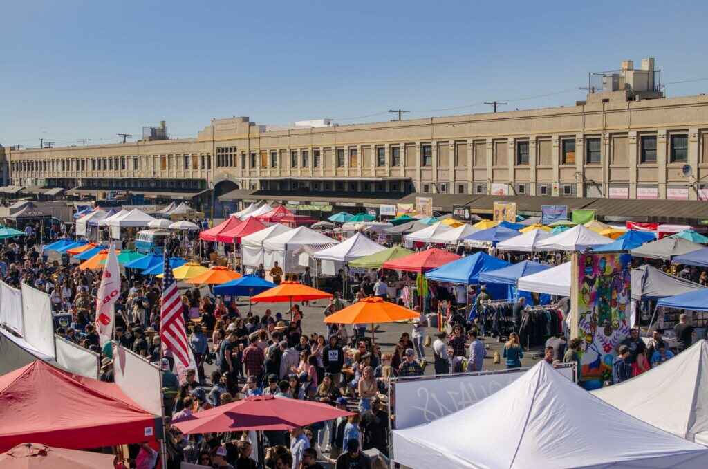
## Description Smorgasburg Los Angeles is one of the city’s most vibrant and eclectic open-air food markets, drawing in foodies, families, and curious visitors every Sunday. What started as a popular market in Brooklyn, New York, has successfully expanded to Los Angeles, where it has taken on its own West Coast identity. The market brings together **dozens of vendors** offering everything from Korean barbecue tacos to vegan donuts, lobster rolls, artisanal coffee, and even experimental food trends that often go viral on social media. What makes Smorgasburg LA unique is not only the incredible variety of food but also its **community-centered atmosphere**. Beyond food, the market also features small retail vendors selling local crafts, clothing, home goods, and artwork. It’s as much a cultural gathering spot as it is a food haven. A little-known fact is that Smorgasburg LA is located on the site of the **old Alameda Produce Market**, connecting today’s modern street food scene with the historic roots of Los Angeles’ food distribution hub. Another fun detail is that the market regularly hosts **pop-up events and chef collaborations**, meaning visitors can often find exclusive dishes available for a limited time. ## Location Smorgasburg Los Angeles is located in the **United States, California, Los Angeles**, specifically in the **ROW DTLA (Downtown Los Angeles)** complex. Its address is **777 S. Alameda Street, Los Angeles, CA 90021**, making it conveniently situated near the Arts District and Little Tokyo. ### Recommendation on How to Get There The easiest way to reach Smorgasburg is by **car**, as it offers a large parking structure with several hours of free parking for market visitors. However, for those who prefer not to drive, public transportation is also an option—the market is accessible via the **Metro Gold Line (Little Tokyo/Arts District Station)**, followed by a short walk. Ridesharing services such as Uber and Lyft are also widely available and recommended if you plan on enjoying craft beers or cocktails at the market. ## Tips Here are some helpful tips for making the most out of your Smorgasburg LA visit: * **Arrive Early**: Popular vendors often have long lines, and some specialty dishes sell out quickly. * **Bring Friends**: Sharing dishes allows you to sample a wider variety of foods without getting too full. * **Bring Cash and Cards**: Most vendors accept cards, but having some cash on hand can speed things up. * **Check the Schedule**: Some vendors rotate weekly, and there are often special events or limited-time pop-ups. * **Wear Comfortable Clothing**: Since the market is outdoors, dress for the weather and wear comfortable shoes. * **Stay Hydrated**: Los Angeles can get hot, so grab drinks from one of the fresh juice or craft soda stalls. * **Don’t Skip the Retail Vendors**: Beyond food, you’ll find unique handmade goods, vintage items, and local art. ## Conclusion Smorgasburg Los Angeles is more than just a food market—it’s an experience that captures the city’s creative energy and love of diverse cuisines. With its wide selection of vendors, lively atmosphere, and mix of food, retail, and entertainment, it’s the perfect Sunday destination in Downtown LA. Whether you’re a local foodie or a visitor exploring the city, Smorgasburg LA offers a taste of Los Angeles’ culinary innovation at its best. ## FAQ **1. What day is Smorgasburg LA open?** Smorgasburg Los Angeles is open every **Sunday from 10 AM to 4 PM**. **2. How much does it cost to enter the market?** Entry is **free**, but you’ll need to pay for food, drinks, and any retail items you purchase. **3. Is there parking available?** Yes, the market offers **several hours of free parking** at the ROW DTLA parking structure for visitors. **4. Are there vegetarian or vegan options?** Absolutely—many vendors specialize in vegetarian, vegan, and gluten-free dishes. **5. Can I bring my kids or pets?** Yes, the market is **family-friendly**, and pets are also welcome, making it a great outing for the whole family. **6. Are the vendors always the same?** Some vendors are permanent, but many rotate, and there are frequent pop-up collaborations, so you’ll often find new foods to try. ## Links * [Official Smorgasburg Los Angeles Website](https://la.smorgasburg.com/)
GemVoyage Team • World
Wroclaw
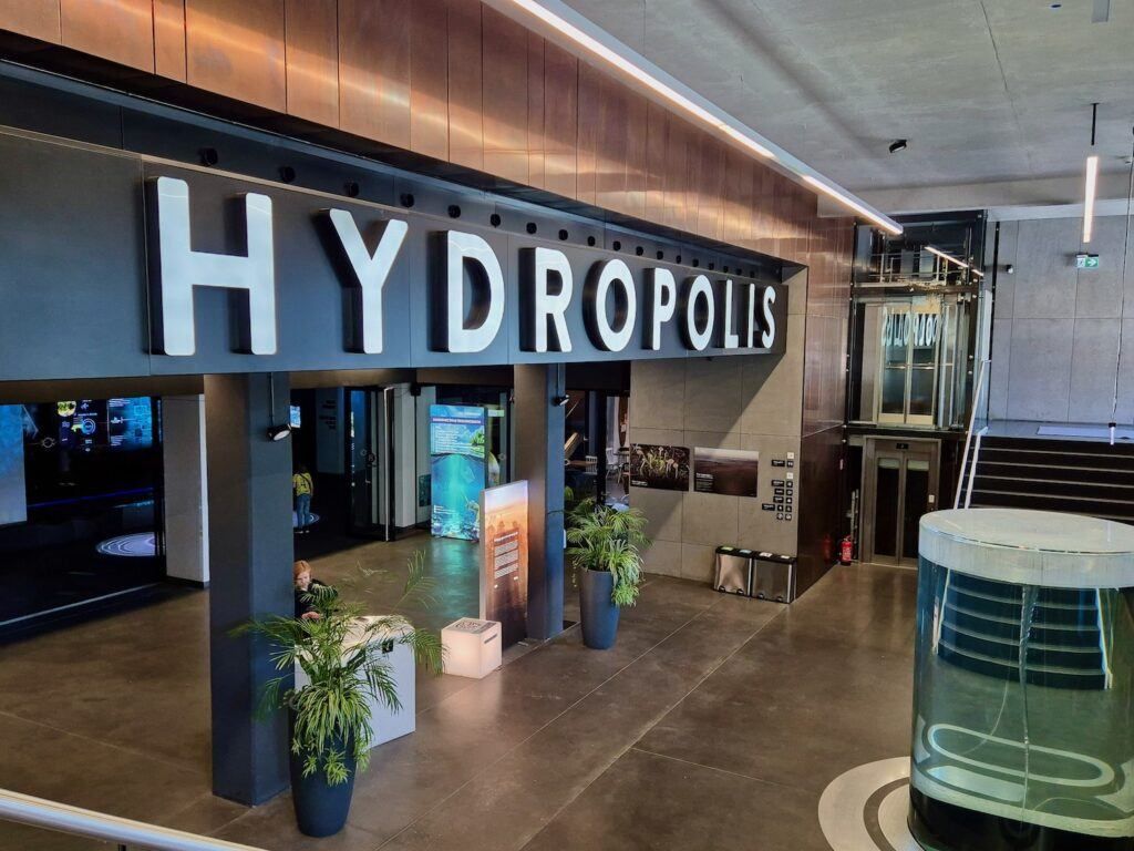
## Description **Hydropolis** is a modern, science-focused museum in Wrocław dedicated entirely to **water**—its origins, physical properties, role in shaping civilizations, and importance for life on Earth. Opened in 2015, Hydropolis stands out not as a traditional museum of static displays, but as a **fully interactive knowledge center** that combines multimedia installations, scientific exhibits, and immersive environments to explain one of humanity’s most essential resources. Housed inside a **19th-century underground water reservoir**, the museum cleverly connects content and setting. The massive brick structure, once used to store drinking water for the city, now forms a dramatic backdrop for exhibitions that explore oceans, rivers, rainfall, hydraulic engineering, and water management. This reuse of industrial heritage is central to Hydropolis’s identity and adds authenticity to the experience. What makes Hydropolis unique is its **interdisciplinary approach**. Visitors move through themed zones covering topics such as deep-sea exploration, water in the human body, ancient hydraulic systems, modern urban water infrastructure, and global water challenges. High-resolution projections, touchscreens, soundscapes, and scale models keep the content accessible without oversimplifying complex scientific concepts. A lesser-known fact is that the building itself was a **technical masterpiece of its time**, constructed in 1893 and hidden underground to preserve water temperature and pressure. Another interesting detail is that Hydropolis devotes significant space to **Poland’s relationship with water**, including flood control on the Oder River and Wrocław’s long history of bridges, canals, and engineering solutions. Hydropolis appeals to a wide audience: families, students, engineers, and travelers interested in science, sustainability, or innovative museums. ## Location **Country:** Poland **Region:** Lower Silesia **City:** Wrocław Hydropolis is located east of Wrocław’s Old Town, near the **Oder River**, in an area known for cultural institutions and green spaces. ### How to Get There * **By tram:** * Several tram lines stop within walking distance, connecting the site to the Old Town and main railway station. * **By bus:** * City buses serve the surrounding district with frequent service. * **On foot:** * About a 25–30 minute walk from the Market Square (Rynek). * **By car:** * Parking is available nearby, though public transport is often more convenient. ## Tips * **Book tickets in advance:** Time slots can sell out, especially on weekends and during school holidays. * **Allow enough time:** Plan at least **2 to 3 hours** to fully experience all exhibition zones. * **Ideal for families:** Interactive elements are well designed for children and teenagers. * **Read the explanations:** Many exhibits reward careful attention rather than quick browsing. * **Combine with nearby attractions:** The Wrocław Zoo and Centennial Hall are close and make a good same-day itinerary. * **Language accessibility:** Exhibits are available in multiple languages, including English. ## Conclusion Hydropolis is one of Poland’s most innovative museums, transforming a historic water reservoir into a compelling educational space. By blending science, history, and modern technology, it offers a deep yet engaging look at water’s role in shaping the planet and human society, making it a must-visit attraction in Wrocław. ## FAQ **1. What is Hydropolis about?** It is an interactive museum focused entirely on water—its science, history, and global importance. **2. Is Hydropolis suitable for children?** Yes. The exhibits are highly interactive and well-suited for families and school groups. **3. How long does a visit take?** Most visitors spend **2 to 3 hours**. **4. Is there an entrance fee?** Yes. Tickets are required, with discounts for children, students, and families. **5. Is Hydropolis accessible for people with disabilities?** Yes. The facility is designed to be fully accessible. **6. Is it worth visiting if I’m not interested in science?** Yes. The visual design and storytelling make the experience engaging even for non-technical visitors. ## Links * [Official Hydropolis website](https://www.hydropolis.pl) * [Wrocław tourism portal](https://visitwroclaw.eu)
GemVoyage Team • World
Tirana
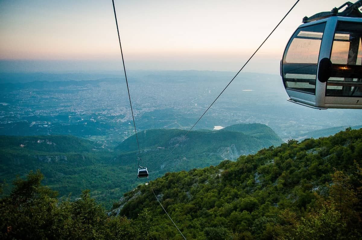
## Description The Dajti Mountain Cable Car, often known as Dajti Express, is one of Tirana’s most memorable experiences because it turns the journey itself into the attraction. Instead of treating the mountains as a distant backdrop, the cable car lifts you gradually from the city’s edge into a greener, quieter world with wide views over the Albanian capital and beyond. For visitors who want to understand Tirana’s geography in a single motion, it is an ideal introduction. What makes the ride special is the contrast. One moment you are near the urban fringe, where streets, buildings, and traffic define the scene; the next, you are moving above slopes and trees with a far more relaxed atmosphere. That dramatic shift is part of the appeal. You do not need to be an adventure traveler to enjoy it. The cable car is accessible, scenic, and unusually effective at showing how quickly the landscape rises around the city. One little-known fact is that Mount Dajti has long served as a natural escape for Tirana residents who want cooler air and open space without going far from the city. Another is that the cable car experience is often most rewarding on days with clear visibility, when the city and surrounding hills spread out in layers below you. The view changes with weather and season, so repeat visitors often discover a different mood each time. The attraction is also useful because it can anchor a full half-day rather than just a single ride. Once you arrive at the upper station, you can enjoy the mountain environment, look out over the city, eat, walk, or simply take in the more spacious setting. That makes the cable car more than transportation. It is a gentle transition from urban Albania to a mountain viewpoint with a strong sense of release. ## Location The cable car operates on the eastern outskirts of Tirana, Albania, ascending toward Mount Dajti and the surrounding national park area. It is close enough to the city to make for an easy excursion, but far enough to feel like a proper escape. Because it is on the edge of the urban area, it is especially convenient to pair with other Tirana sights in the same day. The simplest way to get there is by taxi, ride-hailing service, or private car. Public transport options may require more planning, so many visitors prefer a direct ride to the departure point. If you are staying in central Tirana, plan for a comfortable transfer rather than assuming you can walk. Once at the base station, the cable car itself is straightforward and easy to use. To make the most of the visit, choose a clear day if possible and avoid squeezing the ride into the last minutes of your schedule. The experience is best when you can spend time both on the ascent and at the top. ## Tips - Go on a clear day for the best views. Visibility is a major part of the experience. - Check operating hours and weather conditions before leaving central Tirana. - Bring a light layer, especially if you plan to stay at the top. The temperature can feel different from the city. - Combine the cable car with time at the summit rather than treating it only as a quick ride. - Use the ride to understand Tirana’s geography. It is one of the easiest ways to see how the city meets the surrounding hills. ## Conclusion The Dajti Mountain Cable Car is a simple but memorable way to rise above Tirana and enjoy a calmer, greener setting. It turns a mountain outing into an easy, scenic experience that works for many kinds of travelers. ## FAQ ### Is the cable car suitable for families? Yes. It is a relaxed activity that does not require special fitness or equipment, which makes it a good option for a wide range of visitors. ### How long should I plan for the visit? Plan for more than just the ride. The ascent, time at the top, and return journey together can easily become a half-day outing. ### Is it better to go in the morning or afternoon? Either can work, but morning often offers clearer air and a calmer start. Late afternoon can also be attractive if you want softer light and a more relaxed pace. ### Do I need a guide? No. The cable car is easy to use on your own, and most visitors can enjoy it independently.
GemVoyage Team • World
Seoul
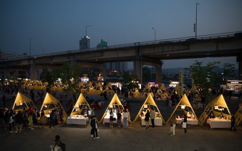
## Description Seoul Bamdokkaebi Night Market is a seasonal night-market program that animates several Han River parks across the city with pop-up vendors, street food stalls, live music, and family-friendly programming. At its core the market offers a curated taste of contemporary Korean street food culture: inventive snack stands, regional specialties, and small-batch artisanal sellers. The markets are deliberately ephemeral—open for limited dates during the warmer months—so each venue (Yeouido, Banpo, Dongjak, for example) develops its own nightly character based on local vendors and event partners. What makes Bamdokkaebi especially appealing is the riverside setting: many stalls sit on grassy banks with views across the river to Seoul’s skyline. That riverside backdrop, combined with stage performances and food trucks, creates a festival atmosphere that balances convenience with discovery. The markets are also a social hub for both residents and visitors—pick-up-and-go menus, picnic-style seating, and ambient lighting make it easy to linger. From a search-engine perspective, typical discoverability terms include "Bamdokkaebi Night Market dates", "Han River night market Seoul", and "Seoul street food market"—keywords that event pages and tourism guides often target. ## Location The program rotates through multiple Han River parks, with popular locations including Yeouido Hangang Park and Banpo Hangang Park. Each park has different entry points and transit connections: Yeouido is accessible via Yeouido Station (Line 5, Line 9), while Banpo Park is close to Express Bus Terminal Station (Line 3, Line 7, Line 9) or Sinbanpo Station on the Shinbundang Line. Check the official Bamdokkaebi schedule for current dates and the specific park hosting that night's market. Because the markets are temporary and sometimes move between sites season-to-season, verify the location and opening times on the Visit Seoul website or official event pages. Weekend nights and public holiday weekends are busiest, while midweek events can feel more relaxed. ## Tips - Check the schedule in advance: markets operate seasonally (commonly spring through autumn) and individual park dates vary. - Arrive early for popular vendors: must-try stalls can develop lines; arriving at opening time increases your chances of tasting signature items without a long wait. - Use public transit: subway and bus access is generally better than driving, as parking near parks is limited during events. - Bring a reusable bag and small change: while many vendors accept cards, cash and smaller denominations help for quick purchases and tipping. - Travel-light: markets are designed for strolling and picnicking—carry a light picnic blanket or sit on the provided benches. - Try local specialties: look for vendors offering regional street-food icons (tteokbokki, hotteok variations, seafood pancakes) alongside modern fusion snacks. - Respect local rules: keep the park clean by using recycling bins and follow any park restrictions on alcohol, fires, or amplified sound. ## Conclusion Bamdokkaebi Night Market is a seasonal, riverside way to sample Seoul’s inventive street-food scene in a lively, communal setting. It's ideal for travelers who enjoy casual dining, outdoor festivals, and a taste of local life. By checking schedules and arriving with a few practical items (cash, transit card, light jacket), visitors can maximize the experience and enjoy a variety of tastes across multiple nights if time allows. ## FAQ Q: When does Bamdokkaebi Night Market usually run? A: The market typically runs from spring to autumn on selected weekends and evenings; dates change yearly, so check the official Visit Seoul schedule. Q: Are pets allowed at the market? A: Policies vary by park; many Han River parks allow leashed dogs in common areas, but vendors or event-specific setups may restrict animals—check the event page. Q: Are there vegetarian or halal options? A: Yes—larger markets usually include vegetarian/vegan stalls and vendors who provide halal-friendly dishes; look for signage or ask vendors directly. Q: Is entry free? A: Yes—park access and market entry are free; you pay per vendor for food and goods. Q: What payment methods are accepted? A: Many vendors accept credit/debit cards and mobile payments; however, smaller stalls sometimes prefer cash—carry some small bills. ## Links - [Bamdokkaebi Night Market](https://www.visitseoul.net)
GemVoyage Team • World

Comments