GemVoyage Team • World
The Fairy Pools on the Isle of Skye in Scotland are a series of crystal-clear, aqua-blue pools and cascading waterfalls that tumble down from the foothills of the Black Cuillin mountains. These natural pools, fed by the Allt Coire a’ Mhadaidh stream, are renowned for their ethereal beauty and have become one of Skye’s most iconic and photographed attractions. Whether you're a hiker, wild swimmer, or simply a lover of dramatic landscapes, the Fairy Pools offer a magical experience that feels straight out of folklore.
The walk to the pools is relatively short—about 2.4 kilometers round trip—and follows a well-maintained gravel path that winds through heather-covered moorland. Along the way, visitors encounter a series of waterfalls and pools, each more striking than the last. The water is so clear that you can see the rocky bottoms and reflections of the surrounding hills, making it a favorite spot for photographers and nature enthusiasts.
A little-known fact: the area around the Fairy Pools was the site of the last and bloodiest clan battle in Scottish history—the Battle of Coire na Creiche in 1601 between the MacLeods of Dunvegan and the MacDonalds of Sleat. Legend has it that the stream ran red with blood, a stark contrast to its current tranquil appearance. Another quirky detail is that despite their name, there’s no historical association with fairies—the name “Fairy Pools” only began appearing in guidebooks in the 20th century.
The Fairy Pools are located in Scotland, on the Isle of Skye, near the village of Carbost in the Highland region. They sit at the base of the Black Cuillin mountains in Glen Brittle, on the western side of the island.
The Fairy Pools on the Isle of Skye are a breathtaking blend of natural beauty and Highland mystique. With their vivid waters, dramatic mountain backdrop, and rich history, they offer a memorable experience for anyone exploring Scotland’s rugged landscapes.
1. Is there an entrance fee to visit the Fairy Pools?
No, the pools are free to visit, but there is a charge for parking.
2. How long is the walk to the Fairy Pools?
The round-trip walk is approximately 2.4 kilometers and takes 40 minutes to 1.5 hours depending on pace and stops.
3. Can I swim in the Fairy Pools?
Yes, wild swimming is allowed, but the water is extremely cold. A wetsuit is recommended.
4. Are the Fairy Pools suitable for children?
Yes, but children should be supervised due to uneven terrain and cold water.
5. Is the site wheelchair accessible?
No, the terrain is rugged and includes steep inclines, making it unsuitable for wheelchairs.
6. What is the best time of year to visit?
Spring and autumn offer mild weather and fewer crowds. Summer is busiest, while winter can be icy and less accessible.
Description
The Fairy Pools on the Isle of Skye in Scotland are a series of crystal-clear, aqua-blue pools and cascading waterfalls that tumble down from the foothills of the Black Cuillin mountains. These natural pools, fed by the Allt Coire a’ Mhadaidh stream, are renowned for their ethereal beauty and have become one of Skye’s most iconic and photographed attractions. Whether you're a hiker, wild swimmer, or simply a lover of dramatic landscapes, the Fairy Pools offer a magical experience that feels straight out of folklore.
The walk to the pools is relatively short—about 2.4 kilometers round trip—and follows a well-maintained gravel path that winds through heather-covered moorland. Along the way, visitors encounter a series of waterfalls and pools, each more striking than the last. The water is so clear that you can see the rocky bottoms and reflections of the surrounding hills, making it a favorite spot for photographers and nature enthusiasts.
A little-known fact: the area around the Fairy Pools was the site of the last and bloodiest clan battle in Scottish history—the Battle of Coire na Creiche in 1601 between the MacLeods of Dunvegan and the MacDonalds of Sleat. Legend has it that the stream ran red with blood, a stark contrast to its current tranquil appearance. Another quirky detail is that despite their name, there’s no historical association with fairies—the name “Fairy Pools” only began appearing in guidebooks in the 20th century.
Location
The Fairy Pools are located in Scotland, on the Isle of Skye, near the village of Carbost in the Highland region. They sit at the base of the Black Cuillin mountains in Glen Brittle, on the western side of the island.
How to Get There
By Car: From Portree, the island’s main town, it’s about a 30-minute drive (20.5 miles) via the B8009 and Glenbrittle road. The route includes single-track roads with passing places.
By Bus: Public transport is limited. Buses run to Carbost, but you’ll need to arrange a taxi or walk from there.
By Tour: Several guided tours from Portree or Inverness include the Fairy Pools as part of a day trip.
By Foot: The walk to the pools begins at the Fairy Pools car park, located near Glenbrittle. From the car park, it’s a 20-minute walk to the first waterfall.
Tips
Visit Early or Late: The site gets crowded during peak hours, especially in summer. Early morning or late afternoon offers better light and fewer visitors.
Wear Waterproof Footwear: The path can be muddy and uneven, especially after rain.
Bring Layers: Weather on Skye is unpredictable. Pack a waterproof jacket and warm clothing.
Wild Swimming: Brave souls can swim in the pools, but the water is icy year-round. A wetsuit is recommended.
Respect Nature: Follow the Scottish Outdoor Access Code—take your litter with you and stick to marked paths.
Parking: There is a charge for parking at the Fairy Pools car park, which helps maintain the site.
Conclusion
The Fairy Pools on the Isle of Skye are a breathtaking blend of natural beauty and Highland mystique. With their vivid waters, dramatic mountain backdrop, and rich history, they offer a memorable experience for anyone exploring Scotland’s rugged landscapes.
FAQ
No, the pools are free to visit, but there is a charge for parking.
The round-trip walk is approximately 2.4 kilometers and takes 40 minutes to 1.5 hours depending on pace and stops.
Yes, wild swimming is allowed, but the water is extremely cold. A wetsuit is recommended.
Yes, but children should be supervised due to uneven terrain and cold water.
No, the terrain is rugged and includes steep inclines, making it unsuitable for wheelchairs.
Spring and autumn offer mild weather and fewer crowds. Summer is busiest, while winter can be icy and less accessible.
Links
Fairy Pools Walk – Isle of Skye Guide
Fairy Pools – VisitScotland Overview
Fairy Pools – Wikipedia Entry
715 words37 lines4484 characters4520 bytes
Discover more hidden gems you might love.
Berlin
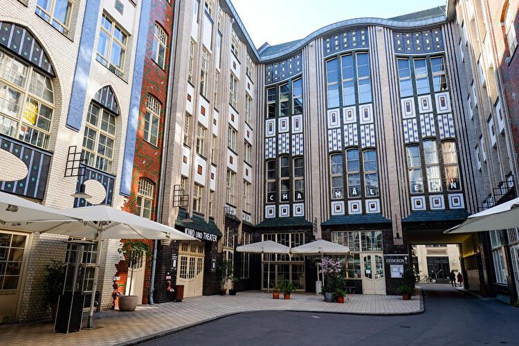
## Description **Hackesche Höfe** is one of Berlin’s most distinctive architectural and cultural complexes, known for its **series of interconnected courtyards**, richly decorated façades, and lively mix of art, retail, and everyday urban activity. Completed in **1906**, the complex was designed by architect **August Endell** and is considered one of the most important examples of **Jugendstil (Art Nouveau)** architecture in Germany. What makes Hackesche Höfe unique is its structure: eight separate courtyards connected by narrow passageways, forming a small urban world within the city. Originally, the complex combined residential apartments, workshops, offices, and entertainment venues, reflecting early 20th-century ideas about efficient mixed-use development. This design allowed craftsmen, artists, and residents to live and work in close proximity, a concept that feels surprisingly modern today. A lesser-known fact is that Hackesche Höfe narrowly escaped demolition during the post-war period, when much of the surrounding area was heavily damaged and later neglected. During the division of Berlin, the complex fell into disrepair, especially in the eastern sector. Its careful restoration in the 1990s played a key role in the **revitalization of Mitte**, helping transform the district into one of Berlin’s cultural and creative centers. Today, Hackesche Höfe hosts boutiques, design shops, cafés, galleries, cinemas, theaters, and apartments. The atmosphere shifts throughout the day, from quiet mornings to lively evenings, making it a place that rewards repeat visits. Despite its popularity, the courtyards retain a sense of intimacy that contrasts with the busy streets just outside. ## Location **Country:** Germany **Region:** Berlin **City:** Berlin **District:** Mitte Hackesche Höfe is located just off **Rosenthaler Straße**, close to Alexanderplatz and the Hackescher Markt area. ### How to Get There * **By S-Bahn:** * Take any line to **Hackescher Markt** station. From there, it is a 5-minute walk. * **By tram:** * Several tram lines stop at Hackescher Markt, offering easy access from across the city. * **By U-Bahn:** * Line U8 to **Weinmeisterstraße**, followed by a short walk. * **On foot:** * Easily reachable from Museum Island and Alexanderplatz. ## Tips * **Explore all courtyards:** Many visitors stop at the first courtyard, but the quieter inner ones are worth seeking out. * **Visit during the day for architecture:** Jugendstil details are best appreciated in natural light. * **Return in the evening for dining and culture:** Restaurants, theaters, and the cinema create a vibrant nightlife atmosphere. * **Be mindful of residential areas:** Some courtyards still contain private apartments. * **Combine with nearby attractions:** Museum Island, Monbijou Park, and the Jewish Quarter are close by. * **Photography is allowed:** Just avoid disturbing patrons or residents. ## Conclusion Hackesche Höfe is a living example of Berlin’s layered history, combining early modern architecture with contemporary creative life. Its courtyards offer a unique way to experience the city’s past and present in a single, walkable space, making it an essential stop for visitors to Berlin. ## FAQ **1. What does Hackesche Höfe mean?** It translates roughly to “Hackesche Courtyards,” referring to the interconnected inner yards. **2. Is there an entrance fee?** No. The courtyards are freely accessible. **3. How long should I plan for a visit?** About **1–2 hours**, depending on shopping, dining, or cultural activities. **4. Are guided tours available?** Occasionally, through private tour operators focusing on Berlin architecture or history. **5. Is Hackesche Höfe suitable for families?** Yes, though it is more oriented toward adults and cultural exploration. **6. What is the best time to visit?** Late afternoon to evening offers a balance of light, atmosphere, and open venues. ## Links * [Berlin tourism official site](https://www.visitberlin.de)
GemVoyage Team • World
Milan
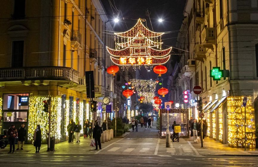
## Description **Chinatown in Milan (Quartiere Cinese di Milano)** is a lively, colorful district that blends **Italian sophistication with Chinese tradition**, creating one of the most vibrant cultural areas in northern Italy. Established in the early 20th century, it is the **oldest and largest Chinatown in Italy**, and today it thrives as a bustling hub of food, culture, and community life. The neighborhood is centered around **Via Paolo Sarpi**, a pedestrian-friendly street lined with Asian grocery stores, authentic restaurants, tea shops, and modern fashion boutiques. Red lanterns and bilingual signs decorate the streets, while the aroma of dumplings, noodles, and roasted duck fills the air. It’s a place where tradition meets innovation — where family-run Chinese bakeries coexist with trendy Milanese cafés and design studios. What makes Milan’s Chinatown unique is how seamlessly it integrates into the city’s cosmopolitan identity. Beyond being a culinary destination, it’s also a **center for art, trade, and cross-cultural exchange**. The area has become increasingly popular among young professionals and artists who appreciate its multicultural atmosphere and creative energy. A little-known fact is that Chinatown in Milan began as a **settlement of Chinese workers from Zhejiang province** in the 1920s, who came to Italy to work in the textile and leather industries. Over time, they established businesses that became essential to Milan’s fashion scene — a legacy that still endures today. Another fascinating detail: every year, the neighborhood hosts an elaborate **Chinese New Year parade**, drawing thousands of locals and tourists to celebrate with dragon dances, fireworks, and street performances. ## Location Milan’s Chinatown is located in the **northwestern part of the city center**, primarily along **Via Paolo Sarpi** in the **Porta Volta area**, **Lombardy region**, **Italy**. To get there: * **By metro:** Take **Line 2 (Green Line)** to **Moscova Station** or **Line 5 (Purple Line)** to **Monumentale Station**. Both are a short walk from Via Paolo Sarpi. * **By tram:** Tram lines **12 and 14** stop nearby. * **By foot:** It’s about a **15–20 minute walk** from the Duomo or Brera district, making it an easy stop during a city stroll. The area is pedestrian-friendly, making it perfect for exploring on foot while sampling food or browsing local shops. ## Tips * **Come hungry:** Chinatown is one of the best places in Milan for authentic Chinese, Vietnamese, and Thai cuisine. Popular dishes include **dim sum, baozi (steamed buns),** and **hand-pulled noodles**. * **Visit during Chinese New Year:** The celebrations are among the largest in Italy, featuring parades, performances, and cultural exhibits. * **Explore side streets:** Don’t just stay on Via Paolo Sarpi — nearby lanes hide charming bakeries, tea shops, and Asian supermarkets. * **Try local fusion spots:** Milan’s creativity shines through in restaurants that blend Asian and Italian flavors, reflecting the district’s evolving culinary scene. * **Shop for Asian ingredients:** Supermarkets like **Kathay** are famous for offering rare spices, sauces, and produce that are hard to find elsewhere in Italy. * **Visit in the evening:** As the lights come on, the red lanterns and street buzz create a magical, cinematic atmosphere. ## Conclusion **Chinatown in Milan** is far more than a neighborhood — it’s a living story of migration, adaptation, and community. From its early days as a textile hub to its present status as a vibrant cultural destination, it reflects Milan’s openness and diversity. Whether you’re tasting authentic dim sum, shopping for exotic ingredients, or celebrating Chinese New Year, Chinatown offers a sensory journey through the heart of modern multicultural Milan. ## FAQ **1. When was Chinatown in Milan established?** It was founded in the **1920s** by Chinese immigrants, mainly from Zhejiang province, who came to work in textile and leather industries. **2. Where exactly is it located?** It centers around **Via Paolo Sarpi**, in the **Porta Volta area** of **Milan**, **Lombardy, Italy**. **3. What can I do there?** You can explore Asian shops, enjoy authentic Chinese cuisine, visit tea houses, and attend cultural festivals such as Chinese New Year. **4. Is it safe to visit Chinatown at night?** Yes, it’s considered safe and lively, with many restaurants and bars open until late. **5. What’s the best time to visit?** Any time of year is great, but **January or February** during the **Chinese New Year** offers the most festive experience. **6. Are there Italian-Chinese fusion restaurants?** Yes, several trendy eateries combine Asian flavors with Italian ingredients, reflecting the creative spirit of Milan’s dining scene. ## Links * [Official Milano Tourism Portal](https://www.yesmilano.it)
GemVoyage Team • World
Baalbek
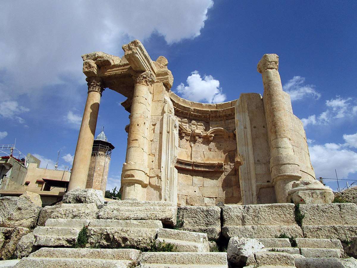
## Description The Temple of Venus in Baalbek, Lebanon, is a captivating remnant of Roman architecture and religious history, tucked within one of the most impressive archaeological complexes in the Middle East. Built in the 3rd century AD, this temple stands out for its **unusual circular design**, a departure from the more common rectangular Roman temples. It was dedicated to Venus, the Roman goddess of love and beauty, and its elegant structure reflects the sensuality and grace associated with her worship. Unlike the colossal temples of Jupiter and Bacchus nearby, the Temple of Venus is more intimate in scale but no less remarkable. It sits atop a horseshoe-shaped platform and features a circular shrine with a square entrance. The outer façade is adorned with five niches, each decorated with carvings of doves and shells—symbols traditionally linked to Venus. These details, along with the temple’s baroque-style curves and arches, showcase a fusion of Roman and Hellenistic architectural techniques. A little-known fact: the temple was later converted into a Christian church dedicated to Saint Barbara, a martyr whose legend is still revered in Lebanon. According to tradition, she was killed by her pagan father for converting to Christianity, and the temple’s continued use as a sacred site reflects the layered religious history of Baalbek. Today, a small mosque stands nearby, underscoring the site’s enduring spiritual significance across centuries and faiths. ## Location The Temple of Venus is located in **Lebanon**, within the **Baalbek-Hermel Governorate**, in the ancient city of **Baalbek**. This city lies in the **northern Bekaa Valley**, a region known for its fertile lands and rich historical tapestry. ### How to Get There: - **By Car**: From Beirut, Baalbek is about a 2-hour drive northeast. The route via Zahle offers scenic views of the Bekaa Valley. - **By Bus**: Public minibuses run from Beirut’s Cola Station to Baalbek, though schedules can be irregular. - **By Tour**: Many guided tours from Beirut include Baalbek’s temple complex, often paired with visits to Anjar or Ksara Winery. Once in Baalbek, the Temple of Venus is just a short walk from the main entrance to the Roman ruins, southeast of the Temple of Jupiter. ## Tips for Visitors To make the most of your visit to the Temple of Venus, consider these tips: - **Visit Early or Late**: The site can get hot and crowded midday. Morning or late afternoon offers better lighting and fewer tourists. - **Wear Comfortable Shoes**: The terrain is uneven, with ancient stones and gravel paths. - **Hire a Guide**: A local guide can provide rich historical context and point out hidden details you might miss. - **Respect the Site**: This is a sacred and historical location. Avoid climbing on ruins or touching carvings. - **Bring Water and Sunscreen**: The Bekaa Valley can be dry and sunny, especially in summer. - **Explore the Whole Complex**: Don’t miss the nearby temples of Jupiter and Bacchus, which are among the largest Roman temples ever built. ## Conclusion The Temple of Venus in Baalbek is a graceful and historically rich monument that offers a unique glimpse into Roman spirituality, architectural innovation, and Lebanon’s layered religious heritage. Its elegant design and enduring presence make it a must-visit for history lovers and curious travelers alike. ## FAQ **1. When was the Temple of Venus built?** It was constructed in the 3rd century AD during the Roman Empire. **2. What makes the Temple of Venus unique?** Its circular design, horseshoe-shaped platform, and symbolic carvings distinguish it from typical Roman temples. **3. Is the temple part of a larger complex?** Yes, it’s part of the Baalbek temple complex, which includes the massive temples of Jupiter and Bacchus. **4. Can I visit the temple year-round?** Yes, the site is open daily and accessible throughout the year. **5. Is there an entrance fee?** Yes, entry to the Baalbek ruins requires a ticket, which includes access to the Temple of Venus. **6. Is the site family-friendly?** Absolutely. The complex is suitable for children and offers a fascinating educational experience. ## Links - [Baalbek Temple of Venus – Livius Ancient History](https://www.livius.org/articles/place/heliopolis-baalbek/baalbek-photos/baalbek-temple-of-the-venus/)
GemVoyage Team • World
Siberia
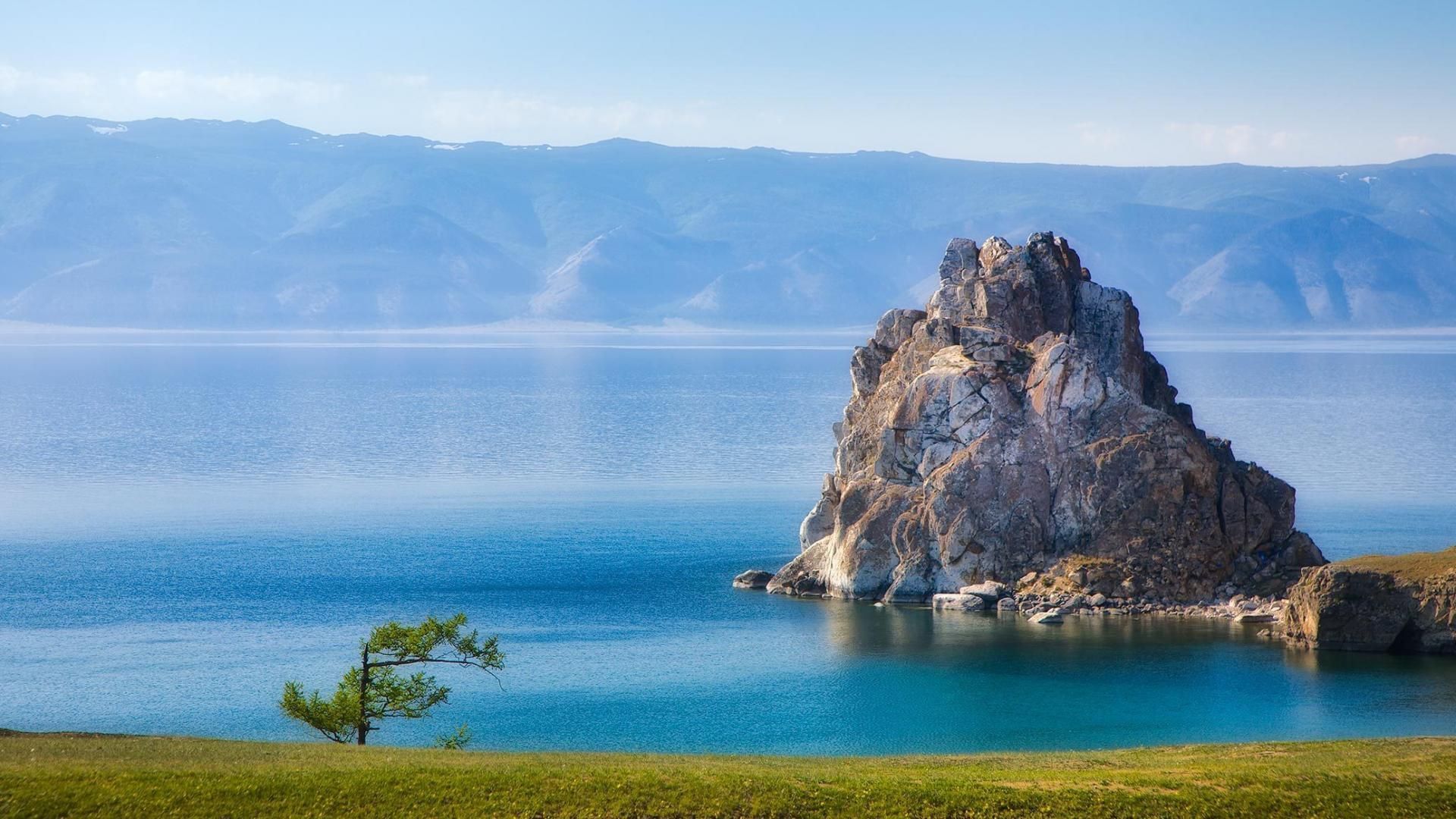
## Description Lake Baikal in southern Siberia is a global natural wonder: the world’s deepest and one of its oldest freshwater lakes, it holds roughly 20% of the planet’s unfrozen surface freshwater by volume. Stretching over 600 kilometers north-to-south and reaching depths of more than 1,600 meters, Baikal’s sheer scale is awe-inspiring. The lake’s crystalline waters, dramatic rifts, and seasonal extremes produce striking phenomena — from the unbelievable clarity of summer waters to the otherworldly expanses of transparent winter ice that allow you to walk, drive, or even ice-sail across a dazzling frozen surface. Baikal is also a hotspot of biodiversity and scientific interest. Its shoreline, submerged terraces, and deep basins host numerous endemic species found nowhere else on Earth, including the Baikal seal (nerpa) — the only seal species that has adapted to a fully freshwater environment — and dozens of endemic fish and invertebrates. The lake’s unique ecology is the result of millions of years of relative isolation, stable cold temperatures at depth, and complex nutrient cycling. Scientists study Baikal to better understand limnological processes, long-term climate records trapped in sediment layers, and the evolution of isolated ecosystems. For travelers, Baikal delivers a rare combination of dramatic landscapes and varied activities across seasons. In summer, the shoreline blooms with wildflowers, and mountain hikes and multi-day treks through taiga and steppe reveal panoramic views over the water. Kayaking, boat excursions, and shoreline camping let you sample the lake’s nearshore biodiversity and peaceful beaches. In winter, when the lake freezes, the surface becomes a vast frozen highway: locals and guides lead safe ice-walking excursions, cross-lake snowmobile trips, ice-fishing experiences, and festivals that celebrate the season. Photographers prize Baikal for its vivid ice formations, clear reflections, and light at dawn and dusk. Beyond natural spectacle, Baikal is threaded with human stories: small lakeside towns such as Listvyanka, the ferry-served Olkhon Island with its shamanic sites, and the city of Irkutsk — a historical gateway with Siberian wooden architecture and museums — are rich portals into local culture. Sustainable and low-impact travel is increasingly available via small-scale guesthouses, ecotour operators, and community-led tours that prioritize the lake’s protection. ## Location Lake Baikal spans the regions of Irkutsk Oblast and the Republic of Buryatia in Russia, with the lake forming a striking spine across southeastern Siberia. The city of Irkutsk is the primary gateway for international and domestic visitors, linked by the Trans-Siberian Railway and regional flights; it offers accommodations, museums, and transport connections. From Irkutsk, paved roads and seasonal bus services reach lakeside settlements like Listvyanka, Port Baikal, and the ferry terminals for Olkhon Island — the lake’s largest island and a cultural heartland with cliffs, shamanic sites, and small villages. Other access points include Ulan-Ude to the east and smaller regional airfields that connect via charter or seasonal flights. Travel times can be long, so many visitors plan multi-day itineraries that combine transit into the lake area with on-site exploration. ## Tips - **Respect seasonal access and local rules:** Ice travel and remote trails require local knowledge; always consult local guides and authorities before venturing onto the ice or into isolated areas. Safety equipment and up-to-date conditions are essential. - **Plan time for Olkhon Island:** Olkhon is a cultural and scenic highlight, with dramatic cliffs, shamanic sites, and small settlements. Allow several days to explore its coves, beaches, and sacred capes. - **Pack for extremes:** Even in summer, weather can shift quickly; bring layered clothing, waterproof shells, sturdy boots, sun protection, and insect repellent. In winter, prioritize thermal layers, insulated boots, and a reliable outer layer. - **Travel with experienced local guides:** Guides provide safety on ice crossings, access to lesser-known shorelines, wildlife-spotting skills, and cultural context about Buryat and Siberian heritage. Choose operators that practice sustainable tourism. - **Respect conservation rules:** Stick to marked paths, avoid disturbing nesting birds or haul-out sites, and follow Leave No Trace principles. Support local conservation initiatives when possible. - **Time your visit for activities:** Summer is best for hiking and kayaking; late spring and early autumn deliver fewer crowds and pleasant light; winter offers unique ice experiences but requires more planning. ## Conclusion Lake Baikal is both a living laboratory and a vast natural wonder: its depth, clarity, and ancient lineage make it one of Earth’s most singular freshwater realms. Whether you come for scientific curiosity, wilderness hiking, cultural exchange with lakeside communities, or simply to witness impossibly clear water and glass-like ice, Baikal rewards patient travel and respectful exploration. Plan carefully, choose sustainable operators, and allow enough time to move slowly around its bays and islands — the lake’s scale is best absorbed at human pace. ## FAQ - **Q: Can you swim in Lake Baikal?** A: Swimming is possible in summer at sheltered beaches and near lakeside villages, but the water remains cold even in peak months; stay near lifeguarded or popular swimming areas, enter gradually to avoid shock, and follow local safety guidance. - **Q: What is the best time to visit Lake Baikal?** A: Late June through September gives the warmest weather, flowering meadows, and easier trekking. Late winter (February–March) is ideal for ice-scenery photography and safe ice excursions when the ice is thickest and the light is crisp. Shoulder seasons offer quieter conditions. - **Q: How do I reach Olkhon Island, and do I need a vehicle?** A: Olkhon is reached via a seasonal ferry or ice road depending on the time of year. Many visitors rent 4x4 vehicles or join guided tours; public buses operate from nearby towns but capacity is limited. Plan logistics in advance, especially in peak season. - **Q: Are there wildlife viewing opportunities?** A: Yes—local guides can help you spot endemic fish species, waterbirds, and in protected offshore areas you may observe Baikal seals. Respect distance guidelines and avoid disturbing habitats. - **Q: Do I need special permits or visas to visit?** A: International visitors need a valid Russian visa. Some protected areas require entry fees or permits for camping and research; check with regional park authorities for up-to-date rules. - **Q: Is Internet and phone coverage available?** A: Coverage varies—cities like Irkutsk and larger settlements have decent mobile data; more remote shorelines and parts of Olkhon have limited connectivity. Prepare for periods offline and download maps or emergency contacts beforehand. ## Links -- [Lake Baikal — Wikipedia](https://en.wikipedia.org/wiki/Lake_Baikal)
GemVoyage Team • World
Cologne
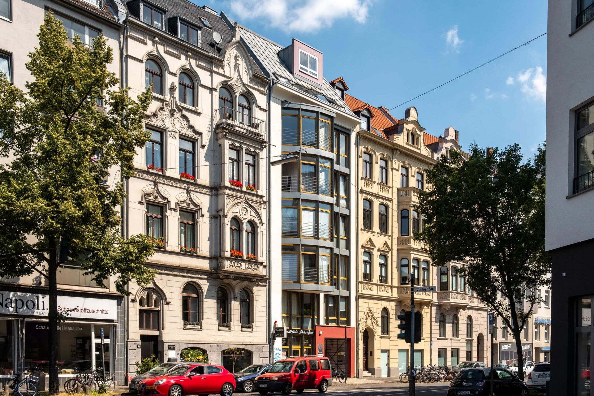
## Description The Belgian Quarter, or Belgisches Viertel, is one of Cologne's most fashionable and creative neighborhoods. Known for its boutiques, galleries, cafes, bars, and attractive residential streets, the district offers a distinctly urban experience that feels polished without becoming impersonal. It is a place where design, food, and everyday city life meet in a compact and walkable area. What distinguishes the Belgian Quarter is its balance of trendiness and livability. Rather than being a single-purpose nightlife zone, it functions as a full neighborhood with shops, apartments, workspaces, and public life. Visitors can browse independent stores, sit at outdoor cafes, look at street art, or simply enjoy the architecture and pace of the streets. The atmosphere is youthful and creative, but not limited to one type of crowd. One lesser-known fact is that the neighborhood's name reflects an old street-naming scheme rather than a strong historical link to Belgium itself. Another is that the area has become a notable center for interior design, fashion, and boutique hospitality, which has helped it develop a reputation as one of Cologne's most style-conscious quarters. That reputation is visible in the carefully curated shopfronts and the relaxed confidence of the streets. The architectural texture of the neighborhood also contributes to its appeal. Tree-lined avenues, classic apartment buildings, and modern retail spaces create an environment that feels pleasant to walk through in almost any season. Because the district is not dominated by one major landmark, the pleasure comes from a series of smaller impressions: a corner cafe, a design store window, a terrace filled with locals, or a low-key bar that becomes lively after dark. For travelers interested in local city culture rather than major monuments, the Belgian Quarter offers a strong sense of Cologne's contemporary lifestyle. It is where people go to meet friends, shop for something unusual, or spend an evening in a setting that feels social but still residential. That gives it a more authentic rhythm than a nightlife strip alone. If you enjoy urban neighborhoods with personality, the Belgian Quarter is one of the best places in Cologne to spend a relaxed afternoon or evening. It is easy to navigate, pleasant to linger in, and rich enough in small details to reward curious travelers. ## Location The Belgian Quarter is located in central Cologne, North Rhine-Westphalia, Germany, just west of the city center. It is easy to reach by tram, bus, or on foot from central Cologne. Once there, the district is best explored on foot because its character depends on browsing, people-watching, and short detours between shops and cafes. ## Tips Go in the afternoon if you want a blend of shopping and cafe culture. If you like design or independent fashion, budget extra time because many stores are worth browsing slowly. Evenings can be lively, but the neighborhood still feels relatively relaxed compared with larger nightlife districts. Combine the visit with a coffee stop or dinner to experience the district's social rhythm. Look beyond the main streets. Some of the best discoveries are one block off the busiest routes. ## Conclusion The Belgian Quarter is one of Cologne's most appealing urban districts, offering a stylish mix of cafes, shops, and neighborhood energy that feels both modern and easygoing. ## FAQ ### Why is it called the Belgian Quarter? The name comes from the street names and the area's historical naming pattern, not from it being a Belgian enclave. ### Is it good for shopping? Yes, especially if you are interested in independent boutiques, design items, and fashion. ### Is the Belgian Quarter touristy? It attracts visitors, but it remains a lived-in neighborhood rather than a purely tourist district. ### What is the best time to visit? Afternoon into evening is ideal if you want to enjoy cafes, shops, and a social atmosphere. ## Links - [Cologne tourism](https://www.cologne-tourism.com/)
GemVoyage Team • World
Manchester
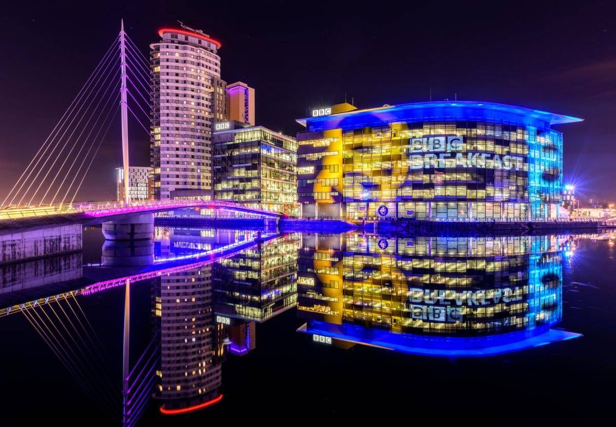
## Description The Quays is one of Manchester’s most dynamic and visually striking waterfront areas, known for its blend of modern architecture, cultural landmarks, and leisure spaces. Once part of the historic Manchester Docks, this area has been completely transformed into a contemporary district that reflects the city’s industrial past while embracing innovation and creativity. Today, The Quays is a popular destination for both locals and visitors, offering museums, media hubs, restaurants, and scenic walking routes along the water. What makes The Quays unique is its successful regeneration story. Formerly an active dock system that played a vital role in Britain’s industrial trade, the area fell into decline in the late 20th century before being reimagined as a cultural and media center. A little-known fact is that the docks here were once among the busiest inland ports in the world. Another interesting detail is that The Quays is home to MediaCityUK, where major broadcasters operate live studios, allowing visitors to see television and radio production happening in real time. With iconic attractions such as The Lowry arts center and the Imperial War Museum North, The Quays offers a balanced mix of history, culture, and modern urban life. ## Location The Quays is located in **England**, in the **Greater Manchester** region, within the city of **Manchester**, primarily spanning the Salford Quays area. It lies just west of Manchester city center, along the Manchester Ship Canal. Getting to The Quays is easy and convenient. The Metrolink tram system provides direct access via stops such as **MediaCityUK** and **Salford Quays**, connecting the area to Manchester Piccadilly and other key parts of the city. Several bus routes also serve the area. For those arriving by car, parking is available at various nearby facilities, though public transport is often the most efficient option. ## Tips * Wear comfortable shoes, as the waterfront paths are ideal for walking and exploring the area on foot. * Visit in the late afternoon or evening to enjoy reflections on the water and vibrant nightlife. * Check event schedules at The Lowry and MediaCityUK, as performances and live broadcasts are frequent. * Combine your visit with a museum stop, especially the Imperial War Museum North, which offers free entry. * Bring a light jacket, as the waterfront can feel cooler and windier than the city center. * Photography enthusiasts will appreciate the modern skyline and waterside views, especially at sunset. ## Conclusion The Quays is a standout example of Manchester’s reinvention, transforming historic docks into a lively cultural and entertainment district. Its mix of museums, media, dining, and scenic walks makes it an essential stop for anyone exploring the city. ## FAQ **Is The Quays suitable for families?** Yes, the area is family-friendly, with open spaces, museums, and regular events suitable for all ages. **How much time should I spend at The Quays?** Most visitors spend between two and four hours, depending on activities and attractions visited. **Are there free attractions at The Quays?** Yes, attractions like the Imperial War Museum North offer free entry. **Is The Quays accessible for people with limited mobility?** Yes, the area is modern and generally well equipped with step-free access and wide pathways. **Can I eat and drink at The Quays?** Absolutely. The area offers a wide range of cafés, bars, and restaurants with waterfront views. ## Links * [The Quays Official Website](https://www.thequays.org.uk)
GemVoyage Team • World

.jpg)
Comments