GemVoyage Team • World
Visitors appreciate Seonyudo for its inviting balance of engineered structure and natural regeneration. The greenhouse and wetland areas host seasonal plantings and migratory birds, while the decks and viewpoints offer long riverside panoramas that are particularly striking at sunset. Beyond the visual appeal, the park operates as a civic classroom: plaques and small exhibits outline the former plant operations and current sustainability initiatives, helping visitors of all ages understand ecological cycles and urban water systems.
Seonyudo’s design also makes it a pleasant social space: picnic spots, quiet courtyards and accessible pathways encourage lingering, and occasional cultural events—workshops, guided ecological walks and small performances—lend the park a local community feel. For urban planners, photographers and families alike, Seonyudo Park is a model of how industrial remnants can be transformed into resilient public amenities.
Because Seonyudo is integrated into the riverfront network, you can combine a visit with a longer riverside ride or walk that links to adjacent parks and cultural districts. The park’s central location makes it an accessible stop during a day exploring Mapo and the west bank of the Han.
Q: Are dogs allowed in the park?
A: Dogs are generally allowed but must be kept on a leash and under control; check posted rules for specific zone restrictions.
Q: Are there restroom facilities and drinking water?
A: Public restrooms and water fountains are available near principal access points, but facilities can be limited—carry water for long summer visits.
Q: Can I cycle across the park?
A: Cycling routes approach and circle the island; on-site cycling may be restricted in certain pedestrian or ecological zones—dismount where indicated.
Q: Is there parking nearby?
A: Limited parking is available along nearby roads, but public transit and cycling routes are the preferred ways to reach the island.
Discover more hidden gems you might love.
Amsterdam
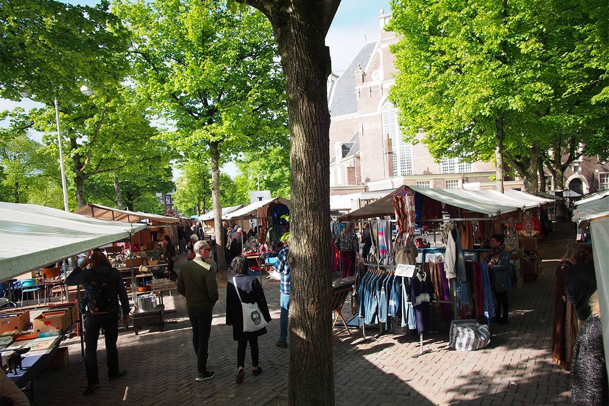
## Description Noordermarkt is one of Amsterdam’s most beloved local market squares, and its reputation comes from how naturally it fits into the fabric of the Jordaan. Rather than feeling like a market created purely for visitors, it feels embedded in neighborhood life. That is a major reason people keep returning. On different days it shifts character: one version is especially known for organic produce, another for antiques and secondhand browsing, but the common thread is a lively, human-scale market atmosphere that reflects Amsterdam at its most practical and convivial. For food travelers, Noordermarkt is a particularly strong stop because the organic market gives you access to fresh, seasonal, and artisanal products in a place that locals actually use. Bakers, cheese sellers, fruit vendors, and farmers bring a quality-first approach that makes browsing feel meaningful rather than transactional. A lesser-known fact is that the square sits beside the Noorderkerk, which means the market occupies a historic urban setting where weekly commerce and neighborhood identity have long been intertwined. Another detail that visitors often appreciate only after arriving is how easy it is to combine market browsing with Jordaan walking routes, canal views, and coffee stops. The atmosphere is relaxed but not sleepy. Noordermarkt has enough energy to feel active, yet it avoids the polished, overproduced feeling that sometimes affects famous market destinations. That is part of its charm. You can browse vegetables, bread, flowers, and prepared foods one moment, then shift to antiques or old objects another day, depending on when you visit. The market is also a good reminder that Amsterdam is a city of local habits, not just major sights. Watching residents shop here tells you something about the city’s pace and values. If you want a market that rewards curiosity and gives you a real sense of the Jordaan, Noordermarkt belongs near the top of your list. ## Location Noordermarkt is located in the Jordaan district of Amsterdam, North Holland, Netherlands, adjacent to the Noorderkerk. The square sits in a central yet neighborhood-oriented part of the city, making it easy to include in a broader day of walking along canals, visiting cafés, and exploring independent shops. Because the Jordaan is one of Amsterdam’s most enjoyable areas on foot, the market works especially well as part of a slow morning or early afternoon route. Getting there is simple by tram, bicycle, or a walk from the historic center. Many visitors find that biking is the most Amsterdam-like way to reach it, though trams and walking are equally practical. Once you arrive, the market is easy to navigate because it is organized around the square and the surrounding streets. If you are interested in the organic market specifically, check the day and time before going, since the square’s character changes across the week. The market is often best in the morning, when produce is freshest and the surroundings still feel animated without being crowded. ## Tips Go early for the best selection, especially if you want produce, bread, or specialty foods. Bring a shopping bag or backpack. The market is ideal for spontaneous purchases, and carrying your own bag makes the experience much easier. Allow time for the neighborhood. Noordermarkt is best when paired with a walk through the Jordaan, so do not treat it as a standalone stop. Be open to seasonal differences. What you find depends heavily on when you visit, and that is part of the appeal. If you enjoy antiques or vintage objects, check whether the day you are visiting aligns with the best browsing opportunities for that side of the market. ## Conclusion Noordermarkt is a classic Amsterdam market with a strong local identity, good food, and a setting that makes it easy to enjoy the Jordaan at a relaxed pace. It is one of the city’s best places to experience daily life with a distinctly neighborhood feel. ## FAQ ### Is Noordermarkt only for tourists? No. It is strongly used by locals, especially for organic produce and everyday shopping, which is a big part of why it feels authentic. ### What can I buy there? Organic food, bread, cheese, flowers, prepared snacks, and on some days antiques or secondhand goods. ### When is the best time to visit? Morning is usually best, particularly if you want the freshest products and a more active market atmosphere. ### Is it easy to combine with sightseeing? Very. Noordermarkt fits naturally into a Jordaan walking route and pairs well with canal-side exploring and nearby cafés. ## Links - [Noordermarkt on Wikipedia](https://en.wikipedia.org/wiki/Noordermarkt)
GemVoyage Team • World
Griva
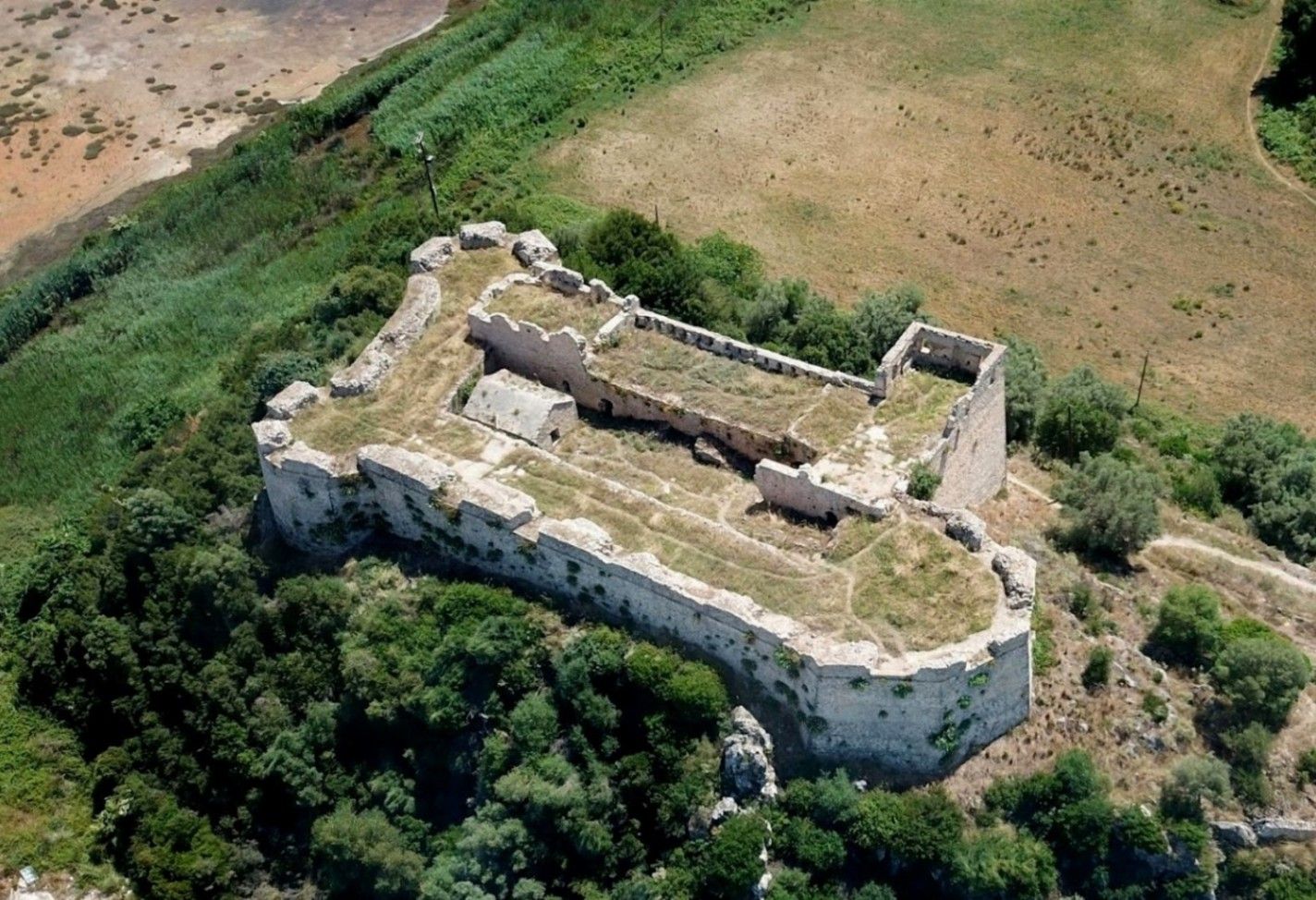
## Description **Griva Castle** (Κάστρο Γρίβα) is a lesser-known but historically significant fortress perched on a ridge in the region of Central Greece. Unlike Greece’s major medieval castles that attract heavy tourism, Griva Castle stands out for its **raw ruins, unfiltered atmosphere, and panoramic vantage point** over the surrounding mountains and valleys. The site is largely untouched by large-scale restoration efforts, which preserves an authenticity that appeals to explorers, hikers, and history enthusiasts seeking off-the-beaten-path destinations. The castle’s origins date back to the **Ottoman period**, when the structure served as a fortified outpost controlling local routes and offering surveillance over the strategic landscape. Its position was not chosen for grandeur but for **tactical visibility**; from the top of the hill, occupants could observe movements across the region long before they reached nearby settlements. Today, visitors can still walk along the remnants of its stone walls, towers, and defensive perimeters, all while imagining the military operations that once shaped the area. A little-known fact is that the castle area was later used during the **Greek War of Independence**, serving as a refuge and observation point for local fighters resisting Ottoman rule. Another interesting detail is that small-scale excavations have revealed architectural traces suggesting earlier defensive uses, which may predate the Ottoman era. What sets Griva Castle apart is the **simplicity of the experience**. There are no curated exhibitions, no ticket booths, and no commercial vendors. Instead, you step into a quiet, windswept landscape that has retained its historic atmosphere. The lack of crowds makes it ideal for slow-paced exploration, photography, and reflection. With clear weather, the views are expansive, capturing rural settlements, forested hillsides, and rolling terrain that highlight the natural beauty of central Greece. ## Location **Country:** Greece **Region:** Central Greece (Sterea Ellada) **Nearest Town:** Griva or surrounding villages depending on the specific approach The castle sits atop a hill overlooking the local countryside, accessible through rural roads and small village paths. ### How to Get There * **By car:** * The most practical option. Rural roads lead to the village area, from which a short uphill walk brings you to the castle ruins. A standard vehicle is usually sufficient, but some paths may be uneven. * **By bus:** * Limited. Regional buses connect nearby towns, but reaching the castle itself generally requires private transport. * **On foot:** * Hiking paths from the village allow visitors to reach the castle in about 15–25 minutes depending on the route chosen. * **By guided tour:** * Occasional historical or hiking groups include the site, but these are not frequent. ## Tips * **Wear proper footwear:** The terrain is rocky, uneven, and sometimes slippery after rain. * **Visit during daylight:** The area has no lighting, and navigating the ruins after sunset is unsafe. * **Bring water and snacks:** There are no facilities near the castle. * **Check the weather:** Clear skies enhance the views significantly and make the hike easier. * **Combine the visit with nearby villages:** Traditional tavernas in surrounding settlements are ideal for a post-hike meal. * **Photography enthusiasts should visit during golden hour:** The light over the surrounding hills is excellent. ## Conclusion Griva Castle is a quiet, rugged, and historically rich destination that rewards visitors willing to venture beyond mainstream tourist circuits. Its ruins, elevated position, and connection to regional history make it a compelling stop for those seeking authentic Greek landscapes and immersive outdoor exploration. ## FAQ **1. Is there an entrance fee?** No. The site is freely accessible to visitors. **2. Are the ruins safe to explore?** Generally yes, but caution is essential due to uneven paths and the absence of barriers. **3. How long does the visit take?** Most visitors spend **45 minutes to 1.5 hours** depending on hiking time and interest. **4. Is it suitable for children?** Only with supervision. Some sections have steep drops and loose stones. **5. Are guided tours available?** Occasionally, especially by local history or hiking groups, but not regularly. **6. What is the best time of year to visit?** Spring and early autumn offer comfortable temperatures and clear views. ## Links * [Greek tourism information](https://visitgreece.gr)
GemVoyage Team • World
Lisbon
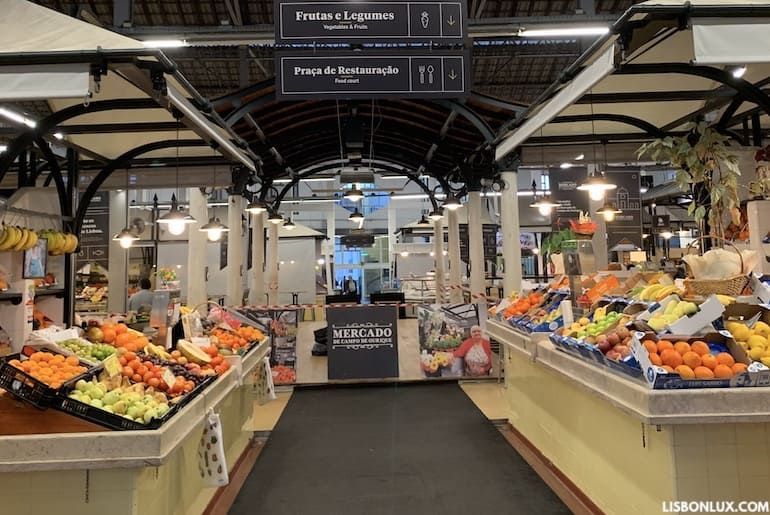
## Description Mercado de Campo de Ourique is a lively neighborhood market in Lisbon that blends traditional market stalls with contemporary food vendors, offering an authentic cross-section of Portuguese culinary life. The market serves locals with fresh produce, fish, meat and pantry items, while an inner food-hall atmosphere provides ready-to-eat dishes, pastries and coffee. What sets Campo de Ourique apart is its local, residential character — it’s not just a tourist attraction but a functioning community hub where Lisbon residents shop and socialize. The market’s architecture is typically covered and airy, with stalls organized around central aisles. Recent renovations have injected a modern food-court vibe alongside still-active traditional vendors, making it a place where you can buy grocery staples in the morning and return later for a relaxed meal. Little-known facts: Campo de Ourique historically developed as a self-contained neighborhood with a strong shopping tradition, and the market has long been a point where multiple culinary generations intersect. ## Location Mercado de Campo de Ourique sits in the Campo de Ourique neighborhood in Lisbon, Portugal, in the western part of central Lisbon near the Estrela and Rato districts. The neighborhood is primarily residential with shops, bakeries and small restaurants lining the streets. Getting there: The neighborhood is accessible by tram, bus and metro. The Rato Metro station and several bus lines serve the area; trams and short walks from nearby attractions make it easy to combine a market visit with broader neighborhood exploration. Taxis and rideshares can drop you near the market’s main entrance. ## Tips - Best times: Morning is ideal for shopping fresh produce and avoiding lunch crowds; midday is excellent for sampling prepared dishes. - What to try: Don’t miss fresh pastries, Portuguese cheeses, cured meats and regional specialties. Many stalls offer ready-to-eat plates — ask vendors for local recommendations. - Payment: Vendors accept cards and cash; small stalls may prefer cash for tiny purchases. - Local etiquette: Bring a reusable bag for purchases; be polite in queues and avoid blocking aisles when tasting or photographing. - Combine visits: Explore nearby bakeries and cafés in Campo de Ourique for a fuller neighborhood taste. ## Conclusion Mercado de Campo de Ourique offers a warm, authentic Lisbon market experience where traditional shopping and contemporary food culture coexist. It’s perfect for visitors seeking genuine neighborhood life, excellent local food and the chance to taste Portuguese everyday cuisine alongside longtime market traditions. ## FAQ Q: Is the market touristy? A: It retains a strong local clientele, though visitors are welcome and many stalls cater to diverse tastes. Q: Are there vegetarian options? A: Yes. Many vendors and food stalls offer vegetarian and vegan-friendly dishes. Q: Can I take food to go? A: Absolutely; many stalls prepare takeaway plates and sandwiches. Q: Is parking available nearby? A: Street parking and small public car parks exist, but public transport is recommended. ## Links [Lisbon Travel Guide](https://www.visitlisboa.com/en)
GemVoyage Team • World
Zürich
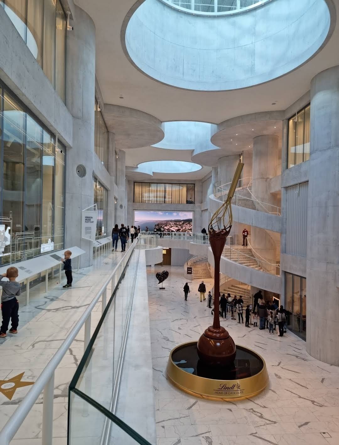
## Description The **Lindt Home of Chocolate** is one of Switzerland’s most delicious attractions, designed to immerse visitors in the fascinating world of Swiss chocolate. Opened in September 2020, this impressive chocolate museum and experience center was created by the Lindt & Sprüngli Foundation and has quickly become a must-visit destination for chocolate lovers worldwide. The highlight of the museum is undoubtedly the **world’s largest free-standing chocolate fountain**, which stands over 9 meters tall and circulates more than 1,000 liters of real liquid chocolate. It’s a breathtaking sight that greets visitors as soon as they enter, setting the stage for a truly mouthwatering experience. Inside, guests can explore interactive exhibitions covering the history of cocoa, the art of chocolate-making, and Lindt’s own story as one of Switzerland’s most beloved brands. Visitors also get to witness master chocolatiers at work in the open kitchen and even create their own chocolate in a hands-on workshop. A lesser-known fact is that the building was designed by the renowned Basel-based architects Christ & Gantenbein, blending modern design with Swiss precision. Another interesting detail is that the museum’s exhibition is available in multiple languages, ensuring that international visitors can enjoy the experience just as much as locals. ## Location The Lindt Home of Chocolate is located in **Kilchberg**, a charming suburb just outside **Zurich, Switzerland**, in the canton of Zurich. The exact address is **Seestrasse 204, 8802 Kilchberg**. Getting there is easy and convenient. From **Zurich’s main train station (Hauptbahnhof)**, visitors can take an S-Bahn train (S1, S8, or S24) to Kilchberg station. From there, it’s just a short walk or a quick bus ride to the museum. Alternatively, a boat ride across Lake Zurich offers a scenic and memorable way to reach Kilchberg. For those traveling by car, parking is available on-site, but spaces can be limited during peak hours. ## Tips To make the most of your visit to the Lindt Home of Chocolate, here are some practical tips: * **Book tickets online in advance** – The attraction is very popular, especially on weekends and holidays, so securing a ticket beforehand is recommended. * **Arrive early** – If you want to enjoy the exhibits and tasting areas with fewer crowds, plan your visit in the morning. * **Don’t miss the chocolate tasting** – The museum includes generous sampling stations where you can taste Lindt’s creations. Come hungry! * **Join a workshop** – For a more interactive experience, sign up for a chocolate-making workshop with Lindt’s master chocolatiers. Spots fill up quickly, so reserve early. * **Visit the shop** – The Lindt store inside is one of the largest chocolate shops in the world, offering exclusive products and unique flavors you won’t find elsewhere. * **Plan about 2–3 hours** – While you can rush through the exhibits in an hour, taking your time allows for a more immersive and enjoyable experience. ## Conclusion The **Lindt Home of Chocolate in Switzerland** is more than just a museum – it’s a celebration of chocolate’s history, culture, and craftsmanship. From the awe-inspiring chocolate fountain to interactive exhibits and hands-on workshops, it’s a dream come true for anyone with a sweet tooth. Conveniently located near Zurich, it’s a must-see destination for travelers looking to indulge in one of Switzerland’s most iconic treasures. ## FAQ **1. How much does it cost to visit the Lindt Home of Chocolate?** Ticket prices vary depending on age and type of visit, but adults can expect to pay around CHF 15–17. Discounts are available for children, students, and groups. **2. How long should I plan for a visit?** Most visitors spend between 2 and 3 hours enjoying the exhibits, workshops, and chocolate tastings. **3. Is the museum family-friendly?** Yes! The Lindt Home of Chocolate is designed for all ages, with interactive displays that both kids and adults can enjoy. **4. Can I buy unique Lindt products there?** Absolutely. The on-site shop is one of the largest Lindt stores worldwide, featuring exclusive products not available elsewhere. **5. Do I need to book in advance?** While walk-ins are possible, booking online in advance is strongly recommended, especially during weekends and holidays. ## Links * [Official Website – Lindt Home of Chocolate](https://www.lindt-home-of-chocolate.com)
GemVoyage Team • World
Paris
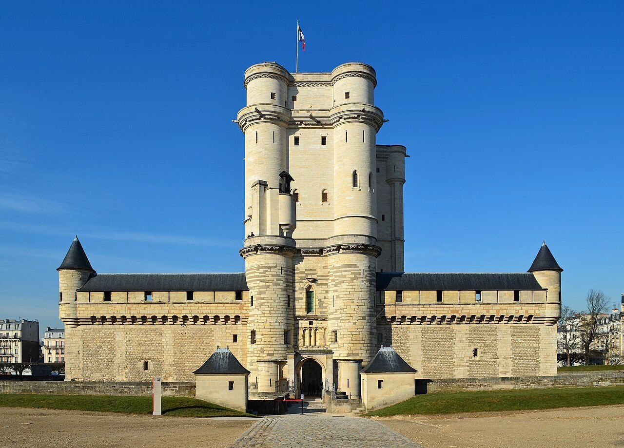
## Description The **Château de Vincennes** is one of France’s most historically significant royal fortresses and a remarkable example of **medieval military architecture** in the heart of modern Paris. Located just east of the city, this vast castle stands as a symbol of the **power, prestige, and evolution of the French monarchy** from the Middle Ages through the Renaissance. Originally built as a **hunting lodge for King Louis VII in the 12th century**, the site was transformed into a formidable **royal fortress** by **King Philip VI** and **King Charles V** during the 14th century. The result was one of Europe’s largest and most impressive medieval castles, complete with towering walls, fortified gates, and a majestic **52-meter (170-foot) keep** — the tallest medieval fortified tower in Europe. The keep, surrounded by a deep moat, served as both a **royal residence** and a **symbol of authority**. Inside, visitors can explore beautifully preserved **royal apartments**, **chapels**, and **ceremonial halls** that once housed some of France’s most powerful monarchs, including **Charles V**, **Henry IV**, and **Louis XIV**. Before Versailles rose to prominence, Vincennes was the main royal residence of the French crown. What makes the Château de Vincennes truly unique is its **dual character** — both royal and defensive. The complex includes a massive **curtain wall with nine towers**, a **drawbridge**, and a **gothic-style chapel** modeled after Sainte-Chapelle in central Paris. Over the centuries, it also served as a **royal prison**, holding famous figures such as **the Marquis de Sade**, **Denis Diderot**, and **Mirabeau**. A lesser-known fact is that the **castle was occupied by Napoleon Bonaparte’s troops**, later used as a **military arsenal**, and even served as a **command center during World War II**. Despite its turbulent past, the site remains remarkably well-preserved and offers a fascinating journey through 800 years of French history. Today, the Château de Vincennes stands as a peaceful yet awe-inspiring monument — less crowded than central Paris landmarks, making it an ideal destination for history enthusiasts seeking authenticity and atmosphere. ## Location The **Château de Vincennes** is located in the **suburb of Vincennes**, directly east of **central Paris**, within the **Val-de-Marne (Île-de-France)** region. It sits adjacent to the **Bois de Vincennes**, Paris’s largest public park. To get there: * **By metro:** Take **Line 1** to **Château de Vincennes Station**, which is just outside the main entrance. * **By RER:** The **RER A** also stops at **Vincennes Station**, about a **5-minute walk** from the castle. * **By bus:** Several Paris bus lines serve the area, including **46, 112, and 114**. * **By car:** Easily accessible via the **Périphérique** (Porte de Vincennes exit), with nearby paid parking available. * **By bike or on foot:** The surrounding **Bois de Vincennes** area offers scenic paths leading directly to the château. ## Tips * **Take the guided tour:** It offers rich historical context about the kings, prisoners, and architects who shaped the site. * **Visit the Sainte-Chapelle de Vincennes:** A stunning Gothic chapel that rivals its Parisian namesake in beauty and craftsmanship. * **Climb the keep:** The panoramic view from the top reveals both the castle’s vast grounds and the Paris skyline. * **Go early or late in the day:** To enjoy a quieter experience and capture the best light for photos. * **Combine with nearby attractions:** After your visit, explore the **Bois de Vincennes**, **Parc Floral de Paris**, or the **zoo** — all within walking distance. * **Family-friendly:** Wide courtyards and open spaces make it a great outing for families and children. * **Check for exhibitions:** The castle regularly hosts **temporary exhibitions, medieval fairs, and reenactments**. ## Conclusion The **Château de Vincennes** is a living testament to the grandeur and endurance of French royal history. With its soaring towers, Gothic chapel, and centuries of royal intrigue, it offers visitors a journey from the medieval era to modern France — all within reach of central Paris. Far less crowded than the city’s major monuments, it’s a place where you can truly feel the **power, elegance, and mystery** of France’s royal past. Whether you’re fascinated by architecture, military history, or French monarchy, the Château de Vincennes promises an experience both majestic and intimate. ## FAQ **1. When was the Château de Vincennes built?** Construction began in the **14th century** under **Philip VI** and **Charles V**, though the site dates back to a 12th-century royal hunting lodge. **2. What is the château known for?** It is renowned as **France’s largest medieval royal fortress**, featuring Europe’s tallest keep and a beautifully preserved Gothic chapel. **3. How can I get there from central Paris?** Take **Metro Line 1** directly to **Château de Vincennes Station** — it’s the last stop on the line and just a few minutes’ walk from the castle. **4. Are guided tours available?** Yes, guided tours in French and English are offered daily and provide detailed insights into the château’s rich history. **5. How long should I plan for a visit?** Allow about **2–3 hours** to explore the keep, chapel, and grounds at a comfortable pace. **6. Is it suitable for children?** Yes — children often enjoy exploring the towers and open courtyards, and there are family-friendly tours available. **7. When is the best time to visit?** Spring and early autumn offer pleasant weather and fewer crowds, though the château is open year-round. ## Links * [Wikipedia page](https://en.wikipedia.org/wiki/Ch%C3%A2teau_de_Vincennes)
GemVoyage Team • World
Cape Town
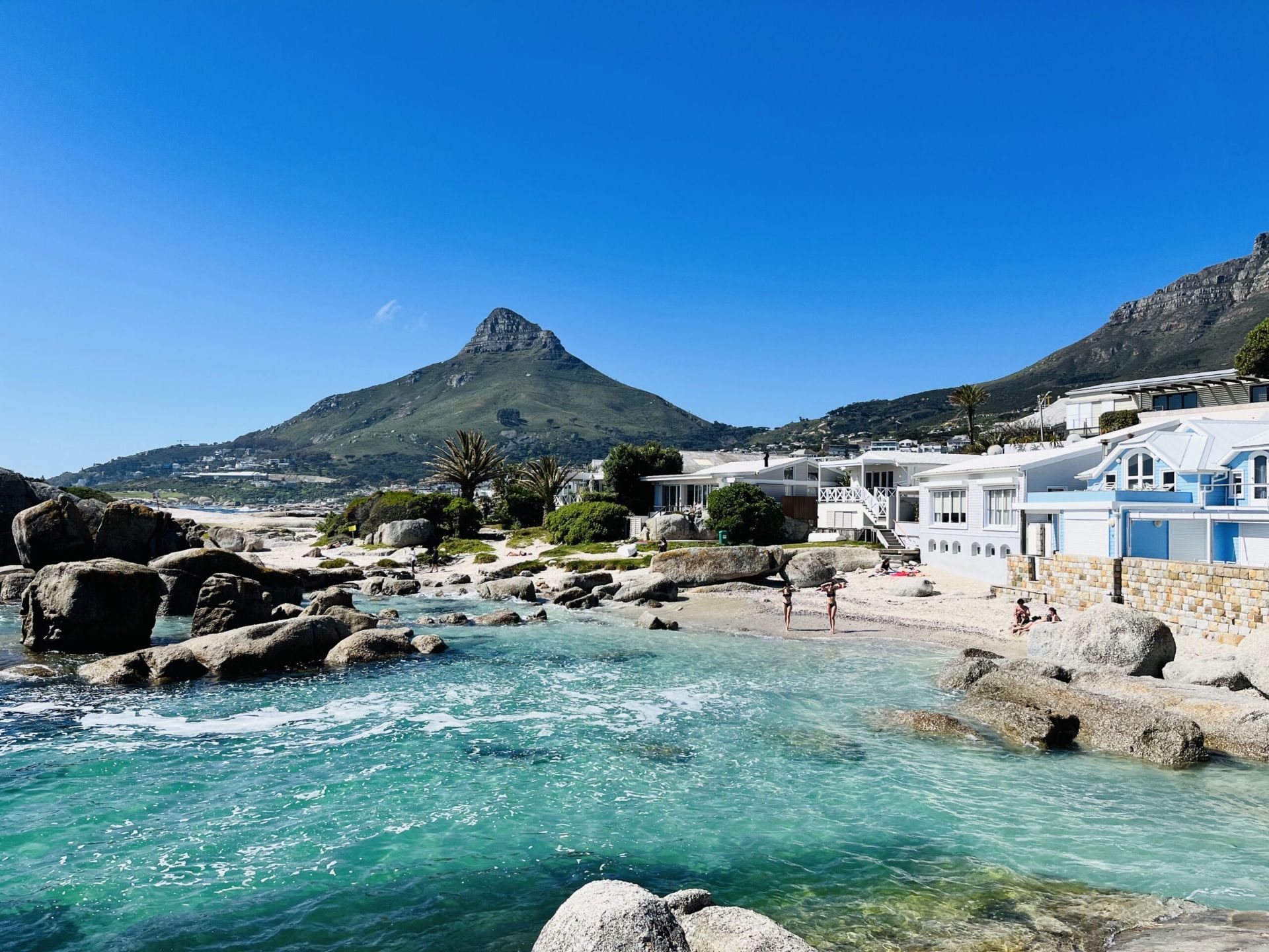
## Description Beta Beach in Bakoven is one of Cape Town’s more understated coastal spots, which is exactly what makes it appealing. Instead of the intensity of the city’s bigger, more famous beaches, Beta Beach offers a calmer setting where granite boulders, sheltered sand, and Atlantic water create a beautiful but low-key experience. The beach feels intimate and local, with views that are every bit as memorable as those at more famous shoreline destinations. What sets Beta Beach apart is the way it blends privacy and scenery. It is not a beach for large crowds or big facilities; it is a beach for people who want to pause, look out over the ocean, and enjoy the dramatic relationship between water and mountain. The Bakoven area itself has a strong residential character, which helps keep the atmosphere relaxed. One lesser-known fact is that the smaller coves in this part of the coast can look very different depending on tide and swell, so a single visit can feel dramatically different from one hour to the next. Another interesting detail is how the surrounding boulders create natural windbreaks and visual frames, making the beach especially photogenic. Beta Beach is also a good choice for travelers who want a quieter Atlantic side experience without giving up proximity to major Cape Town attractions. It works well as a short stop, a sunset watchpoint, or a place to linger between drives along the coast. The mountain backdrop and ocean light make it feel distinctly Cape Town, but in a softer, more residential register than some of the city’s busier beaches. For many visitors, that balance of accessibility and peace is the reason it becomes a favorite. ## Location Beta Beach is in Bakoven, Cape Town, Western Cape, South Africa, along the Atlantic coast near Camps Bay and the route toward the Twelve Apostles side of Table Mountain. The location is close to one of the city’s most scenic coastal corridors. The easiest way to get there is by car or ride-hailing service, especially if you are staying in central Cape Town, Camps Bay, or Sea Point. Public transport options are more limited for this particular stretch, so direct road access is usually the practical choice. Once there, plan to explore on foot so you can enjoy the coves and viewpoints at a slower pace. ## Tips Check tide and weather conditions before visiting, because the beach’s feel changes significantly with the sea. Bring sun protection and water, since the Atlantic coast can be sunny and exposed. Go near sunset for especially strong light on the water and mountains. Keep expectations realistic: this is a beautiful, quieter beach rather than a full-service resort area. ## Conclusion Beta Beach is a peaceful Cape Town coastal stop that pairs Atlantic beauty with a relaxed, local atmosphere. ## FAQ ### Is Beta Beach crowded? It is generally quieter than Cape Town’s most famous beaches, though it can still be busy at peak times. ### Can you swim there? People do swim, but Atlantic conditions can be cold and variable. ### Is it easy to find? Yes, especially if you are already traveling through Bakoven or nearby Camps Bay. ### Is it good for photography? Very much so, especially at sunrise or sunset. ### What makes it different from Camps Bay? It is smaller, quieter, and more sheltered, with a more intimate feel. ## Links - [Cape Town tourism information](https://www.capetown.travel/) - [Camps Bay on Wikipedia](https://en.wikipedia.org/wiki/Camps_Bay)
GemVoyage Team • World


Comments