GemVoyage Team • World
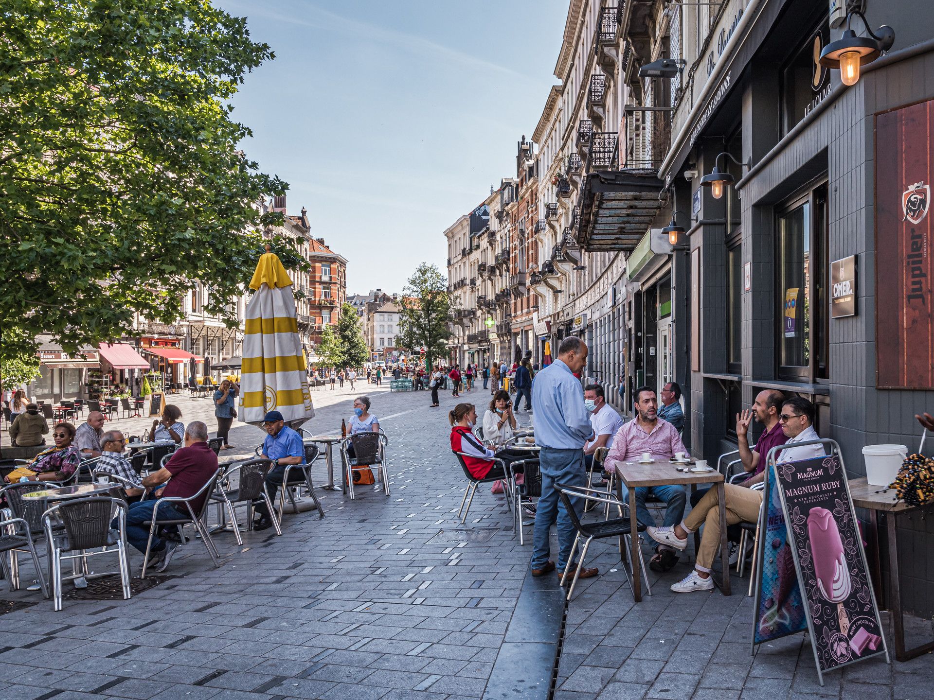
The neighborhood stands out because it combines elegance and texture. You will find Art Nouveau and eclectic architecture, busy local streets, small shops, community energy, and a range of everyday scenes that make the area feel authentic rather than curated. A lesser-known fact is that Saint-Gilles has long attracted artists, creatives, and socially diverse residents, which helps explain its visual and cultural variety. Another detail many visitors notice is the way the neighborhood shifts from quiet residential blocks to more animated streets with cafés, bakeries, and independent businesses, creating a sequence of moods within a relatively compact area.
For visitors, the appeal is that Saint-Gilles rewards wandering. You can walk without a strict plan and still encounter buildings worth noticing, neighborhood squares, and cafés that reflect local rhythm rather than generic tourism. The district also works well if you enjoy comparing Brussels neighborhoods, because it feels distinct from the more polished central commercial zones and from the quieter residential areas elsewhere in the city.
Saint-Gilles is especially good for travelers who want a more grounded version of Brussels. It gives you a sense of people living, working, and socializing in ways that feel immediate and real. That quality is often more memorable than a single headline monument.
The easiest way to get there is by tram, metro, or on foot from central Brussels depending on your starting point. Many visitors find that a walk into Saint-Gilles helps the neighborhood reveal itself gradually. Once there, the streets are best explored slowly, with a mix of aimless wandering and a few concrete stops such as cafés, architectural highlights, or local squares.
If you are planning a Brussels visit that includes multiple neighborhoods, Saint-Gilles fits well alongside Ixelles, the city center, or other south-side districts.
Look up at the façades. Saint-Gilles is one of the better Brussels districts for architectural variety.
Stop at a local café or bakery. The neighborhood is best experienced through everyday routines as much as sightseeing.
Be open to small discoveries. A side street or square may end up being more interesting than a famous landmark.
Use it as a neighborhood day rather than a single-photo stop. The area rewards longer, slower exploration.
Discover more hidden gems you might love.

Myanmar
## Description Bagan is an ancient archaeological zone in central Myanmar where thousands of Buddhist temples, stupas and pagodas dot a broad dry plain along the Irrawaddy River. Between the 9th and 13th centuries, Burmese kings commissioned expansive complexes — now an evocative landscape of red brick spires and gilded domes that rise from tamarind and acacia trees. Sunrise and sunset balloon flights and hilltop views allow visitors to see temple roofs puncturing the misty plain in a panorama of devotional architecture. Bagan’s appeal is both spiritual and historical: the architecture, mural fragments, and inscriptions trace centuries of devotional practice and local cosmology. Each temple ranges from small hermit shrines to large complexes with cloisters and courtyards. Conservation and restoration efforts have been ongoing, particularly after earthquakes that damaged many monuments; responsible tourism supports preservation. Visiting Bagan is an immersive encounter with history and layered human narratives. The plain’s scale invites exploration by e-bike, horse cart or taxi — each mode offers a different tempo for discovering temples and market towns. Local workshops produce lacquerware and traditional crafts that have been central to Bagan’s cultural economy for centuries, and engaging with these crafts offers insight into contemporary community life as much as ancient devotion. Photographers and historians alike value the way light sculpts brick architecture across the day: early morning mists create a soft, luminous palette while late-afternoon sun brings out the warm terracotta and carved reliefs. Responsible visitation is essential. Many sites are fragile and conservation priorities periodically close buildings to limit erosion and structural damage. Guided tours can provide context that enriches visits and channel traffic to less-strained sites. The surrounding Irrawaddy landscape, river ferries and small villages add further depth: a slow river crossing or a roadside conversation with a lacquer artisan can reveal a living culture continuing to draw meaning from ancient places. ## Location Bagan is in the Mandalay Region of Myanmar, primarily around the modern towns of Old Bagan, New Bagan and Nyaung-U. Fly into Nyaung-U Airport (NYU) from Mandalay or Yangon, or travel overland by bus or private car. Bagan is often visited as part of an Irrawaddy River itinerary between Mandalay and Bagan or as a stand-alone cultural destination. Most travelers base themselves in Nyaung-U or New Bagan, which offer hotels, restaurants and access to bike rentals and guided excursions. Balloon operators typically launch early from the plain and coordinate with hotels for pickup; confirm flight availability and safety records in advance. Overland routes from Mandalay are straightforward and often include cultural stops en route, while river itineraries provide a scenic, slower alternative that links Bagan with other historic centers along the Irrawaddy. ## Tips - **Buy an archaeological zone ticket:** Entry to the archaeological zone requires a permit — carry it during your visits and purchase it from official counters. - **Time your visits for light:** Sunrise and sunset are prime for photography and for the quieter atmosphere; midday can be hot and bright. - **Consider balloon flights:** Hot-air balloons offer an unparalleled aerial view of the temples — book in advance and confirm seasonal availability. - **Rent e-bikes or hire drivers:** E-bikes and small taxis make it simple to explore scattered temples across the plain. - **Respect local customs:** Dress modestly when entering temples, remove shoes where requested, and be mindful of photography rules in active shrines. - **Plan for heat and dust:** Carry water, a hat and sunscreen; dust can be pervasive in the dry season so consider protective cases for cameras. - **Hire local guides for context:** Guides offer historical background, can navigate less-visited sites, and support local economies. - **Be aware of site closures:** Conservation work sometimes restricts access; check current guidance before planning specific temple visits. - **Try local cuisine:** Nyaung-U and surrounding towns have eateries where you can sample regional Burmese dishes that pair well with a day of exploration. ## Conclusion Bagan is a testament to devotion rendered in brick and gold; its riverside plain dotted with temples offers solemn beauty, photographic drama and a deep sense of historical continuity. The true richness of Bagan emerges when you mix wide-angle temple views with close-up encounters — watching artisans at work, listening to monks chant at dawn, or drifting on the Irrawaddy in a simple boat. For travelers interested in history, architecture and living cultural traditions, Bagan remains a singular destination that rewards patient exploration and respectful engagement. ## FAQ - **Q: Can you climb the temples?** - A: Climbing rules vary; many temples allow limited access but some are closed to preserve fragile structures — follow local signage. - **Q: Is ballooning available year-round?** - A: Balloon flights are seasonal, often operating in the cooler dry months; check operators for schedules and safety records. - **Q: How many days to explore Bagan?** - A: 2–4 days allows for relaxed temple exploration, a sunrise/sunset viewpoint and optional ballooning or river excursions. - **Q: Is it safe to ride e-bikes around the temples?** - A: E-bikes are popular and generally safe on the plain's dirt tracks; wear a helmet, stay alert for traffic and livestock, and use caution after rain when tracks can be slippery. - **Q: What is the best time of year to visit?** - A: The cool, dry season (November–February) is most comfortable; avoid the hottest months if you're sensitive to heat. - **Q: Are there restrictions on photography inside temples?** - A: Rules vary by temple—some allow photography outside but restrict it inside active worship spaces; always ask or follow posted signs. - **Q: Where can I buy authentic lacquerware?** - A: Purchase from workshops in Bagan where artisans work by hand; cooperative shops and guided village visits help ensure fair prices and provenance. ## Links - [Bagan — Wikipedia](https://en.wikipedia.org/wiki/Bagan)
GemVoyage Team • World
Lahore
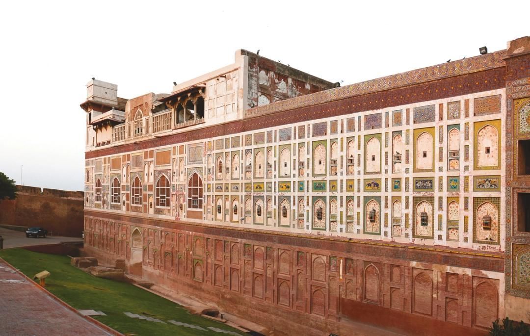
## Description The Walled City of Lahore is one of the most important historic urban districts in South Asia, and it remains one of the best places to understand Lahore beyond its modern boulevards and commercial districts. This is not a museum in the usual sense. It is a living city, layered with Mughal, Sikh, colonial, and contemporary life, where narrow streets, bazaars, mosques, havelis, gates, and food stalls all sit inside a dense and animated urban fabric. Walking here gives travelers a direct sense of how history can still function as everyday geography. What makes the Walled City especially memorable is the density of stories inside a relatively small area. Famous landmarks such as Lahore Fort and the Wazir Khan Mosque are only part of the experience. The streets between them are full of craftsmanship, household life, spices, textile traders, and small businesses that have carried local traditions forward for generations. A little-known fact is that the old city once had multiple gates that structured movement in and out of the historic center, and traces of that gate-based identity still shape how people talk about the district today. Another detail many visitors miss is that the area has been the focus of major restoration work in recent years, which means the old streets are not simply surviving on neglect; they are being actively revived, studied, and reinterpreted. For many travelers, the Walled City is the strongest argument for spending time in Lahore at all. The district makes it easy to move from monumental architecture to street-level life in a matter of minutes. You can stand in front of a grand Mughal monument, turn into a lane with a bakery or metalworker, and then step into a food stall or market that feels intensely contemporary. That overlap is what gives the old city its power. It is historic, but never frozen. It is crowded, but never empty of meaning. ## Location The Walled City of Lahore is in old Lahore, Punjab, Pakistan, centered around the historic core near landmarks such as Lahore Fort, the Badshahi Mosque, Delhi Gate, and the Shahi Guzargah route. It sits in the older part of the city, west of the modern commercial districts and north of several major roads that connect the old center to the rest of Lahore. If you are staying elsewhere in the city, the easiest way to reach it is by taxi, rideshare, or rickshaw. Public transport can help for some parts of the city, but the old city itself is best approached with a direct vehicle drop-off followed by walking. Because the streets are narrow and active, walking is the best way to experience the district once you arrive. It is worth planning the visit carefully rather than trying to see everything at once. Many travelers prefer to enter through a major gate area and then move toward one or two anchor sites rather than forcing a linear route. If possible, use a local guide or an itinerary that combines architecture, street food, and history, since that helps reveal details that are easy to miss on your own. ## Tips - Wear comfortable shoes, because the best way to experience the Walled City is on foot. - Go early or later in the afternoon to avoid the most intense heat and traffic. - Consider hiring a guide if you want the historical layers explained in context. - Dress respectfully, especially if your route includes religious sites. - Keep your schedule flexible, because the district is best enjoyed slowly. - Bring small cash for snacks, tea, and local purchases. ## Conclusion The Walled City of Lahore is a rare historic district that still feels fully alive. It rewards slow exploration, local curiosity, and patience, and it offers one of the richest urban experiences in Pakistan. ## FAQ ### Why is the Walled City of Lahore important? It is one of the oldest and most culturally significant parts of Lahore, with historic gates, monuments, bazaars, and living traditions. ### How much time should I spend there? Half a day is a practical minimum, but a full day is better if you want to include food and major monuments. ### Is it safe to visit with a guide? Yes. Visiting with a knowledgeable local guide can make the experience easier, richer, and more efficient. ### What should I see first? Lahore Fort, Wazir Khan Mosque, Delhi Gate, and the surrounding bazaars are among the most rewarding starting points. ## Links - [Walled City of Lahore Authority](https://walledcitylahore.gop.pk/) - [Wikipedia](https://en.wikipedia.org/wiki/Walled_City_of_Lahore) - [UNESCO Lahore Fort](https://whc.unesco.org/en/list/171/)
GemVoyage Team • World
Griva
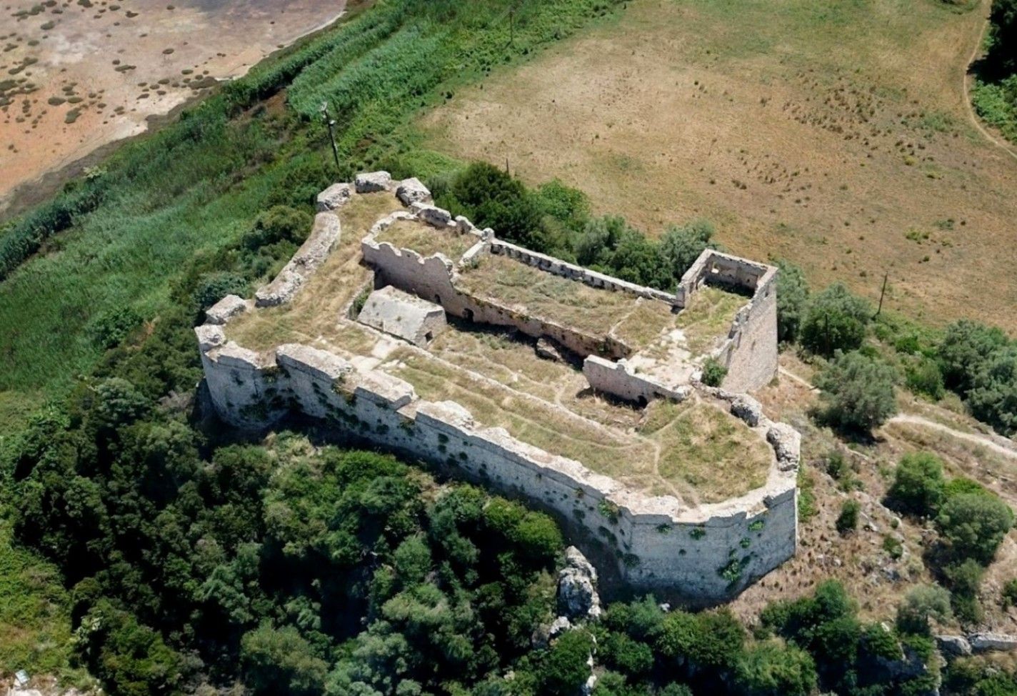
## Description **Griva Castle** (Κάστρο Γρίβα) is a lesser-known but historically significant fortress perched on a ridge in the region of Central Greece. Unlike Greece’s major medieval castles that attract heavy tourism, Griva Castle stands out for its **raw ruins, unfiltered atmosphere, and panoramic vantage point** over the surrounding mountains and valleys. The site is largely untouched by large-scale restoration efforts, which preserves an authenticity that appeals to explorers, hikers, and history enthusiasts seeking off-the-beaten-path destinations. The castle’s origins date back to the **Ottoman period**, when the structure served as a fortified outpost controlling local routes and offering surveillance over the strategic landscape. Its position was not chosen for grandeur but for **tactical visibility**; from the top of the hill, occupants could observe movements across the region long before they reached nearby settlements. Today, visitors can still walk along the remnants of its stone walls, towers, and defensive perimeters, all while imagining the military operations that once shaped the area. A little-known fact is that the castle area was later used during the **Greek War of Independence**, serving as a refuge and observation point for local fighters resisting Ottoman rule. Another interesting detail is that small-scale excavations have revealed architectural traces suggesting earlier defensive uses, which may predate the Ottoman era. What sets Griva Castle apart is the **simplicity of the experience**. There are no curated exhibitions, no ticket booths, and no commercial vendors. Instead, you step into a quiet, windswept landscape that has retained its historic atmosphere. The lack of crowds makes it ideal for slow-paced exploration, photography, and reflection. With clear weather, the views are expansive, capturing rural settlements, forested hillsides, and rolling terrain that highlight the natural beauty of central Greece. ## Location **Country:** Greece **Region:** Central Greece (Sterea Ellada) **Nearest Town:** Griva or surrounding villages depending on the specific approach The castle sits atop a hill overlooking the local countryside, accessible through rural roads and small village paths. ### How to Get There * **By car:** * The most practical option. Rural roads lead to the village area, from which a short uphill walk brings you to the castle ruins. A standard vehicle is usually sufficient, but some paths may be uneven. * **By bus:** * Limited. Regional buses connect nearby towns, but reaching the castle itself generally requires private transport. * **On foot:** * Hiking paths from the village allow visitors to reach the castle in about 15–25 minutes depending on the route chosen. * **By guided tour:** * Occasional historical or hiking groups include the site, but these are not frequent. ## Tips * **Wear proper footwear:** The terrain is rocky, uneven, and sometimes slippery after rain. * **Visit during daylight:** The area has no lighting, and navigating the ruins after sunset is unsafe. * **Bring water and snacks:** There are no facilities near the castle. * **Check the weather:** Clear skies enhance the views significantly and make the hike easier. * **Combine the visit with nearby villages:** Traditional tavernas in surrounding settlements are ideal for a post-hike meal. * **Photography enthusiasts should visit during golden hour:** The light over the surrounding hills is excellent. ## Conclusion Griva Castle is a quiet, rugged, and historically rich destination that rewards visitors willing to venture beyond mainstream tourist circuits. Its ruins, elevated position, and connection to regional history make it a compelling stop for those seeking authentic Greek landscapes and immersive outdoor exploration. ## FAQ **1. Is there an entrance fee?** No. The site is freely accessible to visitors. **2. Are the ruins safe to explore?** Generally yes, but caution is essential due to uneven paths and the absence of barriers. **3. How long does the visit take?** Most visitors spend **45 minutes to 1.5 hours** depending on hiking time and interest. **4. Is it suitable for children?** Only with supervision. Some sections have steep drops and loose stones. **5. Are guided tours available?** Occasionally, especially by local history or hiking groups, but not regularly. **6. What is the best time of year to visit?** Spring and early autumn offer comfortable temperatures and clear views. ## Links * [Greek tourism information](https://visitgreece.gr)
GemVoyage Team • World
Beijing
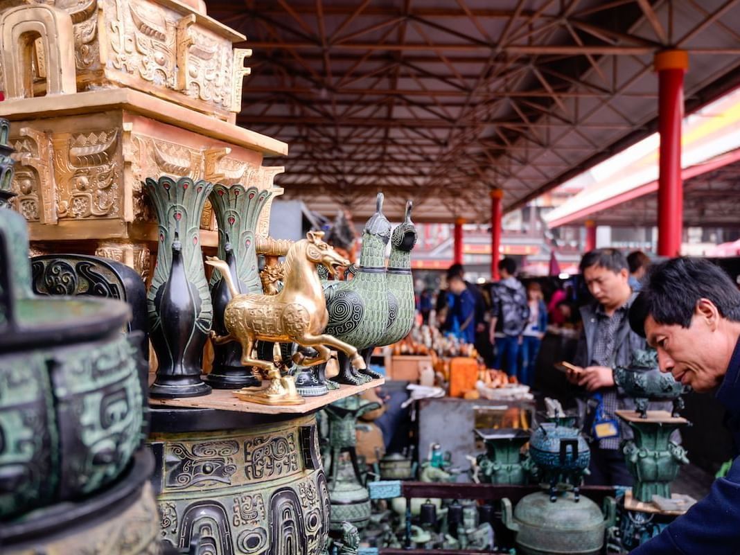
## Description Panjiayuan Antique Market is one of Beijing’s most famous shopping destinations for anyone interested in antiques, collectibles, crafts, and the thrill of browsing through a vast informal market environment. It is not a polished retail complex. It is a sprawling, energetic market where the pleasure comes from looking closely, comparing objects, and discovering what catches your eye. For travelers, that makes it one of the most characterful places to shop in Beijing, especially if you enjoy markets with a sense of surprise. The market is compelling because it contains many different worlds at once. You may find traditional crafts, replica objects, old decorative pieces, calligraphy supplies, beads, paintings, jewelry, souvenirs, and a range of goods that reflect both local taste and the expectations of visitors. A lesser-known fact is that Panjiayuan has long been associated with weekend browsing culture and has become a major destination for both serious collectors and casual shoppers. Another interesting detail is that the market’s atmosphere often changes depending on the time and day of visit, with early morning tending to be the best period for finding variety and doing serious browsing before the crowds become dense. For travelers, the real appeal is less about guaranteed rare finds and more about the experience of looking. Panjiayuan rewards patience, curiosity, and negotiation. It is the type of place where you can spend hours without realizing how much time has passed because every row offers something different. Even if you are not an antique buyer, the market is still fascinating as a cultural snapshot of Beijing’s consumer life and souvenir economy. It is also an excellent place for people who enjoy photography and people-watching, though you should be considerate and ask before taking close photos of vendors or merchandise. The market’s scale and texture make it one of the most memorable commercial spaces in the city. ## Location Panjiayuan Antique Market is located in Chaoyang District, Beijing, China, on the eastern side of the city. Its location makes it accessible from central Beijing while still feeling like a destination with its own identity. Because it is a major market rather than a single storefront, it is best approached with enough time to wander. The easiest way to reach the market is by subway followed by a short walk. Beijing’s metro is usually the most efficient transport method, especially if you want to avoid traffic. Taxis and rideshares also work well if you are carrying purchases or traveling with a group. Once you arrive, the market is straightforward to explore on foot, and the surrounding streets make it easy to orient yourself. If you are serious about browsing, mornings and weekends are often the most rewarding. If you prefer a quieter visit, go earlier in the day or plan around less busy times when possible. ## Tips Bring cash and a willingness to compare prices. Bargaining can be part of the experience, so staying alert is useful. Check items carefully before buying. Quality and authenticity vary, especially with antiques and collectible-style merchandise. Arrive early if you want the widest selection. Serious buyers often do better before the market becomes crowded. Do not expect every item to be a true antique. The market includes a wide range of goods, from genuine older objects to decorative reproductions. Leave enough time to wander without a fixed list. The market rewards discovery more than efficiency. ## Conclusion Panjiayuan Antique Market is one of Beijing’s best places for browsing, bargaining, and discovering objects with personality. It offers a lively, practical, and sometimes unpredictable market experience that many travelers remember long after they leave. ## FAQ ### Is Panjiayuan Antique Market only for collectors? No. It is popular with casual visitors too, especially those who enjoy browsing and shopping for souvenirs or decorative items. ### Can I bargain there? Often yes, though the style and room for negotiation can vary by stall and item. ### What is the best time to visit? Early morning, especially on busier market days, is often the best time for selection and atmosphere. ### Are all items antiques? No. The market includes a mix of antiques, collectibles, crafts, reproductions, and souvenir items. ## Links - [Beijing official tourism](https://english.beijing.gov.cn/) - [Chaoyang District overview](https://en.wikipedia.org/wiki/Chaoyang_District,_Beijing)
GemVoyage Team • World
Brussels
## Description Saint-Gilles is one of Brussels’ most interesting neighborhoods because it feels lived-in, creative, and slightly unruly in ways that make urban travel more rewarding. It is not a single attraction in the conventional sense. Instead, it is a district where architecture, cafés, local life, art spaces, and residential streets come together to form a strong neighborhood identity. For travelers who prefer walking through cities rather than just checking off monuments, Saint-Gilles offers exactly the kind of layered experience that makes Brussels memorable. The neighborhood stands out because it combines elegance and texture. You will find Art Nouveau and eclectic architecture, busy local streets, small shops, community energy, and a range of everyday scenes that make the area feel authentic rather than curated. A lesser-known fact is that Saint-Gilles has long attracted artists, creatives, and socially diverse residents, which helps explain its visual and cultural variety. Another detail many visitors notice is the way the neighborhood shifts from quiet residential blocks to more animated streets with cafés, bakeries, and independent businesses, creating a sequence of moods within a relatively compact area. For visitors, the appeal is that Saint-Gilles rewards wandering. You can walk without a strict plan and still encounter buildings worth noticing, neighborhood squares, and cafés that reflect local rhythm rather than generic tourism. The district also works well if you enjoy comparing Brussels neighborhoods, because it feels distinct from the more polished central commercial zones and from the quieter residential areas elsewhere in the city. Saint-Gilles is especially good for travelers who want a more grounded version of Brussels. It gives you a sense of people living, working, and socializing in ways that feel immediate and real. That quality is often more memorable than a single headline monument. ## Location Saint-Gilles is a municipality and neighborhood area in Brussels-Capital Region, Belgium, located just south of the city center. Its location makes it easy to reach from central Brussels while still feeling like a district with its own identity. Because it is connected to major transport corridors and adjacent neighborhoods, it works well as part of a broader walking itinerary. The easiest way to get there is by tram, metro, or on foot from central Brussels depending on your starting point. Many visitors find that a walk into Saint-Gilles helps the neighborhood reveal itself gradually. Once there, the streets are best explored slowly, with a mix of aimless wandering and a few concrete stops such as cafés, architectural highlights, or local squares. If you are planning a Brussels visit that includes multiple neighborhoods, Saint-Gilles fits well alongside Ixelles, the city center, or other south-side districts. ## Tips Walk without rushing. The neighborhood’s character comes from details in the street life and architecture. Look up at the façades. Saint-Gilles is one of the better Brussels districts for architectural variety. Stop at a local café or bakery. The neighborhood is best experienced through everyday routines as much as sightseeing. Be open to small discoveries. A side street or square may end up being more interesting than a famous landmark. Use it as a neighborhood day rather than a single-photo stop. The area rewards longer, slower exploration. ## Conclusion Saint-Gilles is one of Brussels’ most rewarding neighborhoods for travelers who like authentic city life, architecture, and walkable streets. It offers a strong sense of place that comes from everyday urban texture rather than one big attraction. ## FAQ ### Is Saint-Gilles worth visiting for tourists? Yes, especially if you enjoy neighborhoods with character, architecture, and a local feel rather than purely tourist-oriented sights. ### How long should I spend there? At least a couple of hours if you want to walk, stop for coffee, and notice the neighborhood properly. ### Is it easy to combine with other Brussels areas? Yes. It works well with the city center, Ixelles, and other nearby districts. ### What is the main reason to go? To experience a creative, lived-in part of Brussels that feels distinct from the more polished tourist core. ## Links - [Saint-Gilles on Wikipedia](https://en.wikipedia.org/wiki/Saint-Gilles,_Belgium)
GemVoyage Team • World
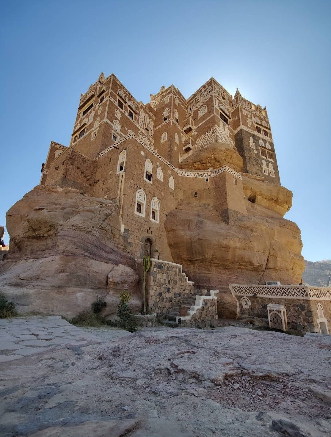
Sanaa
## Description The Stone House in Sanaa is one of the most fascinating architectural wonders in Yemen’s capital. Built entirely from stone, this house reflects the deep-rooted traditions of Yemeni architecture, where natural materials, geometric patterns, and delicate carvings come together in harmony. What makes the Stone House truly unique is its ability to blend strength with elegance—its towering façade is decorated with white gypsum frames and intricate motifs that give it an almost fairy-tale appearance. Unlike many modern buildings, the Stone House is more than just a residence; it represents centuries of history and cultural identity. One little-known fact about this landmark is that it was designed to adapt to the city’s climate: thick stone walls keep the house cool during Yemen’s hot summers and warm during the chilly winter nights. Another fascinating detail is that the windows are often covered with **qamarīyah** (colored stained glass), which not only filters light beautifully but also symbolizes prosperity and protection in Yemeni tradition. ## Location The Stone House is located in **Sanaa**, the capital city of **Yemen**, within the region known as **Old Sanaa**. This UNESCO World Heritage Site is famous for its maze-like alleys, traditional markets (souqs), and iconic high-rise houses made of stone and mud brick. The Stone House is nestled among these historic buildings, making it an essential stop for anyone exploring the old city. To reach Sanaa, international visitors usually arrive via **Sanaa International Airport**. From there, a short drive will take you to Old Sanaa, where most attractions—including the Stone House—are within walking distance. If you are already in the city, taxis are the most convenient way to get there, as public transportation can be limited and sometimes confusing for first-time travelers. ## Tips for Visitors Visiting the Stone House can be an unforgettable experience if you plan properly. Here are some essential tips: * **Best Time to Visit**: The ideal time to explore Sanaa is during the cooler months (October to March), when the weather is more pleasant for walking around the old city. * **Respect Local Culture**: Yemen is a conservative country, so visitors should dress modestly. Women may want to cover their hair with a scarf when entering traditional neighborhoods. * **Hire a Local Guide**: A guide can explain the hidden meanings behind the architecture and help you discover details you might otherwise miss. * **Photography Etiquette**: Always ask before photographing people, especially in residential areas. However, the buildings themselves are a photographer’s dream, so bring a good camera. * **Stay Safe**: Due to Yemen’s political situation, travelers should always check current travel advisories before planning a visit and consider traveling with a trusted tour operator. ## Conclusion The Stone House in Sanaa is more than just an old building—it’s a living symbol of Yemeni history, culture, and artistry. Its unique stone architecture, stained glass windows, and cultural significance make it a must-see destination for travelers interested in heritage and history. Nestled in the heart of Old Sanaa, it offers an authentic glimpse into one of the world’s most remarkable historic cities. ## Frequently Asked Questions (FAQ) **1. What is the Stone House in Sanaa?** The Stone House is a traditional Yemeni building in Old Sanaa, made primarily of stone and decorated with gypsum and stained glass windows. **2. Why is the Stone House important?** It represents Yemeni architectural heritage and showcases how traditional designs were adapted to both climate and culture. **3. Can tourists visit the Stone House?** Yes, visitors can explore it along with other landmarks in Old Sanaa, though it is best to check travel advisories before planning a trip. **4. How old is the Stone House?** While the exact date of construction varies depending on the specific house, most traditional stone houses in Sanaa date back several centuries. **5. Is photography allowed inside the Stone House?** Photography of the building is usually allowed, but always be respectful and ask for permission if entering private areas. **6. How can I reach the Stone House from the airport?** From Sanaa International Airport, it’s about a 30-minute drive to Old Sanaa. Taxis are the most convenient way to get there. ## Useful Links * [UNESCO World Heritage – Old City of Sanaa](https://whc.unesco.org/en/list/385/)
GemVoyage Team • World

Comments