GemVoyage Team • World
The Romanian Athenaeum (Ateneul Român) is one of Bucharest’s most iconic landmarks—a neoclassical masterpiece that stands as a symbol of Romanian culture, resilience, and artistic excellence. Opened in 1888, this circular, domed concert hall is the home of the George Enescu Philharmonic Orchestra and hosts the prestigious George Enescu Festival, one of Europe’s leading classical music events.
Designed by French architect Albert Galleron, the Athenaeum’s architecture is a harmonious blend of neoclassical grandeur and romantic flourishes. Its façade features a stately colonnade, while the interior dazzles with gilded balconies, a massive fresco depicting key moments in Romanian history, and acoustics considered among the finest in the world. The concert hall seats nearly 800 guests, with every seat offering a clear view of the stage and impeccable sound quality.
A little-known fact: the Athenaeum was partially funded through a public campaign with the slogan “Donate one leu for the Ateneu!”—a grassroots effort that united citizens in support of the arts. Another fascinating detail is that the building stands on land once occupied by a monastery and orchard belonging to the Cantacuzino family, adding layers of historical depth to its foundation.
The Romanian Athenaeum is located in Romania, in the Bucharest Municipality, within the Capital Region. Its exact address is Strada Benjamin Franklin 1-3, Sector 1, just off Calea Victoriei, one of the city’s main boulevards.
Its central location makes it a perfect stop on any cultural itinerary through the city.
To make the most of your visit to the Romanian Athenaeum, consider these tips:
The Romanian Athenaeum is a cultural treasure that blends architectural elegance with musical brilliance. Whether you're attending a concert or simply admiring its historic beauty, the Athenaeum offers a deeply enriching experience in the heart of Bucharest.
1. Is there an entrance fee to visit the Romanian Athenaeum?
Yes, for concerts and guided tours. Prices vary depending on the event.
2. Can I visit the Athenaeum without attending a concert?
Yes, guided tours are available outside concert hours, but must be scheduled in advance.
3. What is the seating capacity of the concert hall?
The hall seats approximately 794 guests, including stalls and loges.
4. Is the Athenaeum wheelchair accessible?
Yes, accessibility features are available, but it’s best to contact the venue in advance for assistance.
5. What is the best time to visit?
Evenings during concert season (September to June) offer the most vibrant atmosphere.
6. Are children allowed at performances?
Yes, though some events may have age recommendations. Check the program details before booking.
Discover more hidden gems you might love.
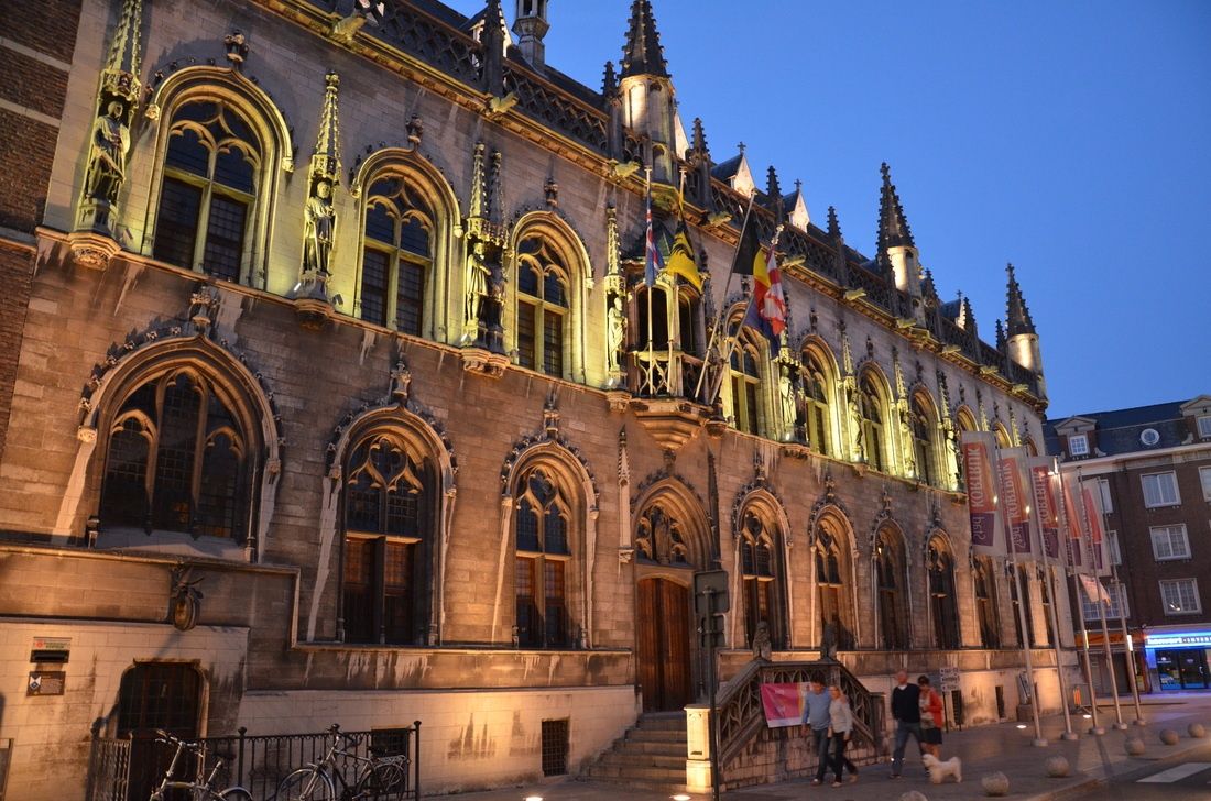
Kortrijk
## Description **Courtrai City Hall**, known locally as **Historisch Stadhuis Kortrijk**, is one of the most architecturally layered civic buildings in Belgium. Rather than being the product of a single era, the City Hall is a **composite structure** formed by the gradual integration of several historic buildings, most notably the medieval Cloth Hall and later Renaissance and Baroque additions. This architectural layering makes it a visual record of Kortrijk’s political, economic, and cultural evolution. The origins of the complex date back to the **14th and 15th centuries**, when Kortrijk was a prosperous center of the Flemish cloth trade. The Cloth Hall section symbolized the city’s commercial power and autonomy, while later expansions reflected its growing administrative role. Over time, stylistic elements ranging from Gothic verticality to Renaissance symmetry were added, resulting in a façade that is rich, complex, and deliberately expressive of civic pride. What makes Courtrai City Hall particularly distinctive is its **ornamental façade**, decorated with statues representing Flemish counts and historical figures associated with the region. These sculptures were not merely decorative; they were political statements asserting local identity and authority during periods of regional tension. A lesser-known fact is that several statues visible today are **19th-century restorations**, replacing originals that were damaged or lost during conflicts and urban changes. Another interesting detail is that parts of the interior were adapted multiple times to accommodate shifting administrative needs, meaning some rooms combine medieval proportions with later decorative finishes. Beyond its architectural value, the City Hall has remained a **living institution**. Unlike many historic civic buildings that function solely as museums, it continues to host municipal activities, official ceremonies, and cultural events. This continuity reinforces its role not just as a monument, but as an active participant in the city’s daily life. ## Location **Country:** Belgium **Region:** Flanders **City:** Kortrijk **Province:** West Flanders Courtrai City Hall is located in the historic center of Kortrijk, close to key landmarks such as the main square and medieval streets that define the city’s core. ### How to Get There * **By train:** * Kortrijk Station has direct connections to Brussels, Ghent, and Lille. From the station, the City Hall is a 10–15 minute walk. * **By bus:** * Local bus routes stop near the city center, within walking distance of the building. * **On foot:** * Easily accessible when exploring Kortrijk’s historic center. * **By car:** * Public parking is available nearby, though walking is preferable in the old town. ## Tips * **Check access times:** Interior access may be limited due to official functions or events. * **Look closely at the façade:** The statues and decorative details tell a political and historical story. * **Combine with nearby sites:** Pair your visit with nearby medieval landmarks and museums. * **Visit during daylight:** Natural light highlights the architectural contrasts between different periods. * **Respect civic use:** Some areas may be restricted during working hours. * **Photography policies vary:** Exterior photography is unrestricted; interior rules may apply. ## Conclusion Courtrai City Hall is a powerful expression of civic identity shaped over centuries. Its layered architecture, historical symbolism, and continued administrative role make it a compelling destination for visitors interested in urban history and Flemish heritage. ## FAQ **1. Is Courtrai City Hall a museum?** No, it is an active municipal building, though some areas may be accessible to visitors. **2. How old is the building?** Its oldest parts date back to the late medieval period, with later additions from subsequent centuries. **3. Can visitors enter the City Hall?** Limited interior access is possible, depending on events and official use. **4. How long should a visit take?** Around **20 to 40 minutes** for an exterior and contextual visit; longer if interior access is available. **5. Is it suitable for children?** Yes, particularly for those interested in history and architecture. **6. Is the building accessible?** Accessibility varies due to the historic structure; some areas may have limited access. ## Links * [City of Kortrijk official site](https://www.kortrijk.be)
GemVoyage Team • World
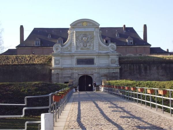
Lille
## Description The Citadel of Lille is one of the most impressive military structures in France and a major reason the city is often mentioned in discussions of European fortress design. Built in the 17th century under the direction of Vauban, the citadel is a star-shaped defensive complex that demonstrates both engineering precision and political ambition. It was intended to protect Lille after the city came under French control, and today it stands as a reminder of how military architecture could also shape a city's identity and landscape. What makes the citadel special is that it is not only technically significant but also visually elegant. Its geometric form, wide moats, robust bastions, and open green surroundings make it feel like a fortress designed by someone who understood both defense and urban order. Even if you are not deeply interested in military history, the citadel is compelling because of how it connects architecture, public space, and the natural environment. It is both a monument and a park-like setting, which gives it a very different feeling from densely built old-town landmarks. One little-known fact is that the Citadel of Lille is sometimes referred to as the "queen of citadels" because of its importance in Vauban's defensive system. Another detail many visitors miss is how well the structure fits into the modern city. Although originally conceived for warfare, the citadel now helps define a recreational and cultural zone where walking, cycling, family outings, and visits to nearby attractions all take place. That transformation from military stronghold to civic landmark is part of what makes the site interesting today. The citadel also helps visitors understand Lille's broader history. The city sat near contested borders for centuries, so fortifications were more than symbolic; they were necessary tools of survival and control. Standing at the citadel, you can sense the strategic value of the location and see how a military engineer like Vauban thought about terrain, sightlines, and access. For architecture lovers, history enthusiasts, and casual walkers alike, it is one of Lille's most rewarding destinations. ## Location The Citadel of Lille is in Lille, in the Hauts-de-France region of France, west of the historic center near the Deûle River and surrounding parkland. Its location makes it easy to combine with a broader exploration of Lille's old quarters, especially if you are already spending time around the city center. Unlike a fortress in a remote military zone, this citadel sits comfortably within the urban fabric while still feeling spacious. Getting there is simple by foot, bicycle, or local transport. If you are staying in central Lille, a walk to the citadel is pleasant and reveals how the city's layout changes as you move from dense streets to more open green space. Buses and taxis can also bring you close, but many visitors prefer to use the approach as part of a longer stroll. Because the citadel is surrounded by parks and walking routes, it works especially well as part of a relaxed day outdoors. You can combine it with the nearby zoo, river paths, or other west-side attractions if you want to make the most of the area. ## Tips Allow time for the surroundings as well as the fortress itself. The citadel's setting in parkland is one of its greatest strengths, and the experience improves when you treat it as part of a broader walk rather than a quick photo stop. If you are interested in military history, read a little about Vauban before visiting. His work shaped many French fortifications, and understanding his methods makes the citadel much more meaningful. Visit in good weather if you want to enjoy the outdoor environment fully. The site is enjoyable year-round, but clear conditions make the geometry and scale easier to appreciate. Bring comfortable shoes or use a bicycle if you plan to cover more of the surrounding area. The citadel fits naturally into an active day in Lille and is especially pleasant for travelers who enjoy a mix of history and open-air walking. ## Conclusion The Citadel of Lille is a landmark of French military architecture and a beautiful place to understand the strategic history of the city while enjoying one of its most open and pleasant landscapes. ## FAQ ### Who built the Citadel of Lille? It was designed by Vauban, the famous French military engineer, in the 17th century. ### Why is the citadel important? It is important because it is one of the best examples of Vauban's fortification work and a key part of Lille's historical defense. ### Can you visit the citadel today? Yes. The area is accessible and widely used for walking and recreation, though access may vary in specific sections. ### Is it close to Lille's city center? Yes. It is located west of the center and is easy to reach on foot or by local transport. ## Links - [Lille tourism](https://www.lilletourism.com/) - [Wikipedia article](https://en.wikipedia.org/wiki/Citadel_of_Lille)
GemVoyage Team • World
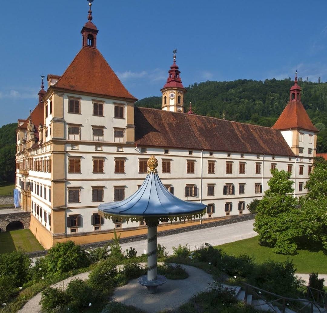
Graz
## Description Schloss Eggenberg (also known as Eggenberg Palace) is an extraordinary Baroque masterpiece perched on the western edge of Graz. What truly sets it apart is its *architectural allegory of the cosmos*: every number in its layout holds symbolic meaning. With **365 exterior windows** (for each day of the year), **31 rooms per floor** (longest month), **24 state rooms** (hours of the day), and **4 corner towers** (seasons or directions), it's a meticulously designed celebration of time and space Inside, the **Planetary Room**—or *Planetensaal*—is a highlight: its ceiling and walls are adorned with astronomical imagery dating back to 1678. The frescoes assign the seven classical planets to weekdays, Roman gods, metals, and members of the Eggenberg family, while the walls are graced by the twelve zodiac signs **Little-known facts**: 1. The palace ingeniously incorporates a medieval Gothic chapel at its core—it was once a family chapel now embedded in the 17th-century layout 2. Hidden in the Japanese Cabinet was a centuries-old folding screen—a paravent depicting Osaka before 1615—which was only recognized post-restoration around 2001–04 --- ## Location Schloss Eggenberg is located in **Graz**, the capital of **Styria (Steiermark)**, **Austria**. The address is Eggenberger Allee 90, 8020 Graz ### How to get there: * From Graz city centre, take **tram line 1**—it’s a direct, scenic route and takes approximately 15 minutes * You can also opt for bus connections (e.g., bus 33 or 62) via nearby tram interchanges, especially useful for reaching the park’s various gate points --- ## Tips for a Great Visit * **Schedule a guided tour**: The lavish state rooms (Prunkräume) are accessible only with guidance, typically offered in German and English. The tour reveals the fascinating symbolic design and stories behind each room * **Visit the Planetary Room early** to beat crowds—it's the visual and symbolic centerpiece. * **Explore the gardens and park**: Entrance to the surrounding landscaped park is affordable (€2 for adults; students and youth 19–26 pay less; under 19 free). From spring to autumn, enjoy themed areas like the Planetengarten, Rose Garden, and all while sharing the space with freely roaming peacocks—a favorite for photos * **2025 STEIERMARK SCHAU special**: This anniversary exhibition (starting April 26, 2025) transforms the state rooms into immersive multimedia spaces exploring the backstories of the palace’s inhabitants—from chambermaids to barbers. Entry is free for this event * **Time your visit after April** if you wish to see interiors—during winter, the rooms remain closed to protect their original condition (no heating or electricity), though the park stays open * **Extend your museum experience**: With a valid ticket, you can also access the Alte Galerie, Archaeology Museum, and Münzkabinett located on site—all part of the Universalmuseum Joanneum --- ## Conclusion Schloss Eggenberg stands not only as one of Austria’s most exquisite Baroque palaces but also as a cosmic narrative carved in stone and fresco. Its unique blend of symbolism, history, and beauty—along with its serene park and evolving exhibitions—makes it a must-visit for anyone in Graz seeking culture within a meaningful, multi-layered architectural gem. --- ## FAQ **1. What makes Schloss Eggenberg unique?** Its architectural design is a calendar in stone—365 windows, 24 state rooms, 31 rooms per floor, and more—symbolizing time and cosmos. **2. Is the palace part of UNESCO World Heritage?** Yes, since 2010, alongside Graz’s historic centre. **3. Can you visit the interiors anytime?** No. The state rooms are typically open April to early November, accessible only via guided tour. They close in winter to preserve their untouched original state **4. What are the opening hours and ticket prices?** * **Park & gardens**: €2 for adults; students and youth get reduced rates; free for under-19s. * **Prunkräume & museums**: Around €15 for adults; youth discounts apply. Check updated hours—usually 10 am to 6 pm during open season **5. Is Schloss Eggenberg accessible via public transport?** Yes—tram line 1 runs directly from the centre to the palace area. Buses (33, 62) also serve the surrounding park entrances. **6. Are there areas suited for families?** Definitely—its expansive park includes playgrounds, thematic gardens like Planetengarten, peacocks, and picnic spots—perfect for a family outing. --- ## Useful Links * [Official Website](https://styriarte.com/en/locations/schloss-eggenberg/)
GemVoyage Team • World
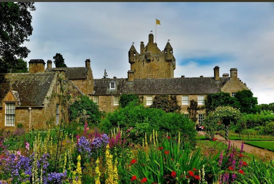
Cawdor
## Description **Cawdor Castle** is one of Scotland’s most enchanting castles, steeped in history, myth, and natural beauty. Built around a legendary holly tree in the late 14th century, the castle has been home to the Cawdor family for over 600 years. With its picturesque stone towers, ornate rooms, and beautifully landscaped gardens, it offers visitors a fascinating journey through Scottish heritage. The castle is famously associated with Shakespeare’s *Macbeth*. While the historical Macbeth never lived here, the castle has become linked to the play because of its title, the Thane of Cawdor. This literary connection, combined with the castle’s authentic medieval charm, makes it an especially intriguing stop for literature lovers and history enthusiasts alike. Inside, visitors can explore grand drawing rooms, antique furniture, fine art collections, and centuries-old tapestries. Outside, the estate features three distinct gardens: the **Walled Garden**, the **Flower Garden**, and the **Wild Garden**, each showcasing Scotland’s flora in different styles and seasons. A little-known fact is that the castle’s origin story is tied to a prophecy. According to legend, the Thane of Cawdor dreamed he should build his castle where a donkey lay down to rest under a tree. That tree still stands today in the castle’s cellar, preserved as a unique piece of history. Another hidden gem is the castle’s woodland trails, which cover over 100 acres and are home to wildlife such as red squirrels and roe deer. ## Location Cawdor Castle is located in the **Scottish Highlands**, about **12 miles east of Inverness**, in the **village of Cawdor, Nairnshire, Scotland**. Its Highland setting adds to its charm, with rolling landscapes, ancient forests, and nearby rivers. The easiest way to reach Cawdor Castle is from **Inverness**, which has good road, rail, and air connections. From Inverness, the castle is just a 25–30 minute drive by car via the A96 and B9090 roads. Visitors without a car can take a train to **Nairn** and then a short taxi ride to the castle. For international travelers, **Inverness Airport** is located only about 15 minutes away, making the castle very accessible as part of a Highland tour. ## Tips To enjoy your visit to Cawdor Castle to the fullest, keep these tips in mind: * **Check seasonal opening times** – The castle is usually open to visitors from late April to early October, so plan accordingly. * **Book tickets online** – During peak tourist season, advance booking is recommended to avoid queues. * **Take your time in the gardens** – Each garden offers a different experience, so don’t rush. Spring and summer are especially beautiful. * **Explore the woodlands** – The nature trails are less crowded and perfect for a quiet walk surrounded by Highland wildlife. * **Photography** – While photos are allowed outside, check the guidelines for indoor photography, as some rooms may restrict it. * **Combine with nearby attractions** – Cawdor Castle can be paired with a visit to Culloden Battlefield or Loch Ness for a full day of Highland history and scenery. ## Conclusion **Cawdor Castle in Scotland** is a captivating blend of history, legend, and natural beauty. With its ties to Shakespeare, legendary holly tree, and stunning gardens, it offers visitors a truly unique Scottish experience. Whether you’re drawn by literature, heritage, or landscapes, this Highland treasure is well worth the journey. ## FAQ **1. Is Cawdor Castle connected to Shakespeare’s Macbeth?** While the historical Macbeth never lived here, the castle is famously linked to the play because Macbeth is given the title “Thane of Cawdor.” **2. When is the best time to visit?** Late spring and summer are ideal for enjoying the gardens in full bloom, though autumn also brings beautiful colors in the surrounding woodlands. **3. How long should I plan for a visit?** Most visitors spend 2–3 hours exploring the castle interiors, gardens, and woodland trails. **4. Are guided tours available?** Yes, guided tours are often available and provide deeper insights into the castle’s history, legends, and architecture. **5. Can children visit Cawdor Castle?** Absolutely. The gardens and woodlands make it family-friendly, and children can enjoy exploring the outdoor spaces. **6. Is the castle accessible for visitors with mobility issues?** The gardens and some areas are accessible, but due to the historic structure, certain parts of the castle may be difficult to reach. It’s best to check accessibility details in advance. ## Links * [Official Cawdor Castle Website](https://www.cawdorcastle.com) * [Visit Scotland – Cawdor Castle](https://www.visitscotland.com)
GemVoyage Team • World
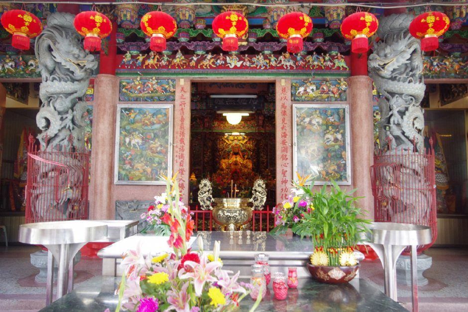
Taiwan
## Description Hualien Cih Tian Temple, known locally as 花蓮慈天宮, is one of the most important religious and cultural landmarks in Hualien City. Dedicated primarily to Mazu, the revered sea goddess and protector of travelers and fishermen, the temple plays a central role in the spiritual life of the local community. It is a place where worship, tradition, and daily life intersect, offering visitors a calm yet vibrant glimpse into Taiwanese religious culture. What makes Hualien Cih Tian Temple unique is its strong connection to the coastal identity of eastern Taiwan. While many Mazu temples are found along Taiwan’s western coast, this temple reflects the beliefs and practices of communities shaped by the Pacific Ocean and Hualien’s rugged natural environment. A lesser-known fact is that the temple has undergone several reconstructions due to earthquakes and typhoons, each time rebuilt with community support, symbolizing local resilience and faith. Another interesting detail is that the temple often serves as a gathering point during important religious festivals, when processions, traditional music, and rituals fill the surrounding streets with color and energy. Architecturally, the temple features classic Taoist design elements, including ornate roof carvings, colorful murals, stone guardian lions, and richly decorated altars. Even outside major festivals, the scent of incense and the quiet rhythm of prayer create a reflective atmosphere that welcomes both worshippers and curious visitors. ## Location Hualien Cih Tian Temple is located in **Taiwan**, in **Hualien County**, within **Hualien City**. The temple sits in a central urban area, making it easily accessible and close to other local attractions, shops, and eateries. Reaching the temple is simple. Visitors arriving by train can walk or take a short taxi ride from **Hualien Railway Station**, which is the main transportation hub of the city. Local buses also operate nearby. For travelers exploring Hualien on foot or by bicycle, the temple fits naturally into a city sightseeing route. If you are using a car or scooter, parking is usually available on nearby streets. ## Tips * Visit in the early morning or late afternoon for a quieter and more contemplative experience. * Dress modestly and respectfully, especially if you plan to observe or participate in prayer. * Take time to observe the architectural details, such as roof sculptures and painted panels, which often depict mythological stories. * If visiting during a festival, expect crowds, noise, and vibrant processions—an excellent cultural experience if you enjoy local traditions. * Avoid blocking worshippers or ritual paths when taking photos. * Combine your visit with nearby markets or temples to better understand Hualien’s urban culture. ## Conclusion Hualien Cih Tian Temple is a meaningful spiritual and cultural site that reflects the faith, history, and resilience of Hualien’s community. Whether you visit for quiet reflection or to witness living traditions, the temple offers an authentic and enriching experience in eastern Taiwan. ## FAQ **Who is the main deity worshipped at Hualien Cih Tian Temple?** The temple is primarily dedicated to Mazu, the sea goddess and protector of sailors and travelers. **Is the temple open to visitors every day?** Yes, the temple is generally open daily, from early morning until evening. **Is there an entrance fee?** No, entrance is free, though donations are welcomed. **Can tourists visit even if they are not religious?** Yes, visitors of all backgrounds are welcome, as long as they remain respectful. **When is the best time to visit the temple?** Weekdays or non-festival days are best for a peaceful visit, while festival periods offer a more lively cultural experience. ## Links * [Hualien County Government](https://www.hl.gov.tw)
GemVoyage Team • World

Tokyo
## Description Sumida Park is a serene riverside oasis in the heart of Tokyo, offering a refreshing contrast to the city’s fast-paced urban energy. Stretching along both banks of the Sumida River, the park is located between the Azumabashi and Sakurabashi bridges and provides stunning views of the Tokyo Skytree rising above the skyline. It’s a favorite spot for locals and tourists alike, especially during spring when the park transforms into one of Tokyo’s most celebrated cherry blossom viewing locations. The park’s history dates back to the Edo period, when the riverbanks were popular gathering spots for hanami (cherry blossom viewing), festivals, and leisurely strolls. Today, Sumida Park continues that tradition with over 600 cherry trees lining the paths, creating a tunnel of blossoms that draws thousands of visitors each year. In summer, the park becomes a prime viewing location for the Sumida River Fireworks Festival, one of Japan’s oldest and most spectacular pyrotechnic displays. A little-known fact: the cherry trees in Sumida Park were planted under the orders of shogun Tokugawa Yoshimune in the 18th century, making the park not only a natural retreat but also a living piece of Tokyo’s cultural heritage. Another quirky detail is the nearby Asahi Beer Tower, visible from the park, which was designed to resemble a frothy mug of beer—a playful architectural nod to the area’s modern flair. ## Location Sumida Park is located in **Japan**, in the **Kanto region**, within the **city of Tokyo**. It spans the **Taito and Sumida wards**, with entrances near the historic Asakusa district and the Sumida River waterfront. ### How to Get There - **By Train**: The park is a five-minute walk from Asakusa Station, served by the Ginza Line, Asakusa Line, Tobu Isesaki Line, and Tsukuba Express. - **By Bus**: Several local buses stop near Asakusa and Sumida Park. - **By Water Bus**: The Tokyo Water Bus docks near the park and offers scenic rides to destinations like Odaiba and Hamarikyu Gardens. - **By Foot or Bike**: The park is easily accessible from nearby neighborhoods and is ideal for walking or cycling along the river. Its central location makes it a convenient stop during a day of sightseeing in eastern Tokyo. ## Tips - **Visit During Cherry Blossom Season**: Late March to early April is peak bloom time. Arrive early to avoid crowds and secure a good picnic spot. - **Stay for the Fireworks**: If visiting in late July, plan to attend the Sumida River Fireworks Festival. Arrive hours in advance for a good viewing location. - **Bring a Camera**: The park offers excellent photo opportunities, especially with Tokyo Skytree in the background. - **Explore Both Sides of the River**: Cross the Sakurabashi pedestrian bridge to enjoy views from both banks. - **Pack a Picnic**: There are no large restaurants inside the park, but nearby Asakusa has plenty of takeout options. - **Check for Events**: Seasonal festivals and cultural performances are often held in the park—check local listings for details. ## Conclusion Sumida Park is a tranquil yet culturally rich destination in Tokyo, offering scenic river views, seasonal beauty, and a deep connection to the city’s history. Whether you're admiring cherry blossoms, watching fireworks, or simply enjoying a quiet walk, the park provides a memorable escape in the heart of the metropolis. ## FAQ **1. Is there an entrance fee to Sumida Park?** No, the park is free and open to the public year-round. **2. When is the best time to visit Sumida Park?** Spring (late March to early April) for cherry blossoms and summer (late July) for the fireworks festival. **3. Are there restrooms and facilities in the park?** Yes, there are public restrooms and seating areas throughout the park. **4. Can I bring pets to Sumida Park?** Yes, pets are allowed but should be kept on a leash and cleaned up after. **5. Is the park wheelchair accessible?** Most paths are flat and accessible, though some areas may have uneven terrain. **6. Are there guided tours available?** While not specific to the park, many Asakusa walking tours include Sumida Park as part of their itinerary. ## Links - [Sumida Park – Japan National Tourism Organization](https://www.japan.travel/en/spot/2114/)
GemVoyage Team • World


Comments