GemVoyage Team • World
What makes the museum powerful is its personal scale. This is not a huge institution where you move through distant galleries at speed. It is a home, and that makes the visit feel immediate. Rooms, objects, colors, domestic details, and artwork come together to create an experience that is both museum-like and deeply human. Visitors often leave with a stronger understanding not only of Kahlo as an artist, but of her life as a person negotiating illness, creativity, politics, love, and independence.
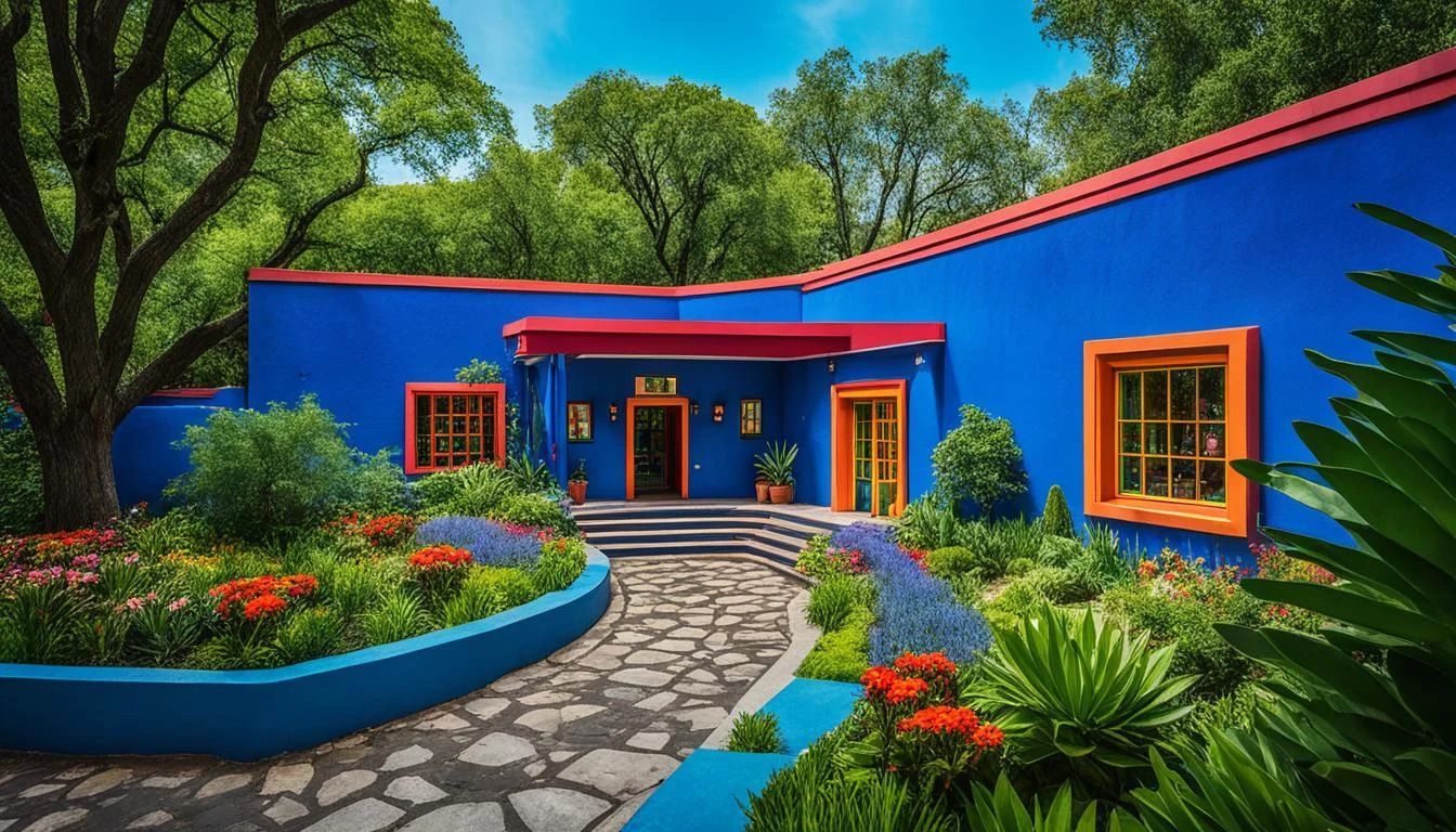
One little-known fact is that the museum houses not only Frida’s works and belongings but also domestic items and visual traces that help reconstruct the atmosphere of the house during her life. Another is that the building itself, with its blue walls and courtyard presence, has become almost as iconic as the artist. The house is immediately recognizable, yet the visit still feels personal rather than monumental. That tension is part of its appeal.
The museum is also meaningful because it sits at the intersection of biography and art history. Frida Kahlo has become a global symbol, sometimes reduced to fashion or image, but Casa Azul reminds visitors that her influence came from a specific place, body, and context. The house makes the symbolic figure tangible. It gives texture to the myth without stripping away its emotional power.
For travelers in Mexico City, this is one of the most essential cultural stops, especially if you want a museum that is memorable, accessible, and full of character. It is best when you arrive ready to pay close attention, because the details matter. The house rewards curiosity and reflection in equal measure.
The most practical way to get there is by taxi, rideshare, or public transport followed by a walk through Coyoacán. Because the museum is popular, timing matters. It is smart to plan your route in advance and allow extra time for entry and neighborhood walking. The surrounding area also gives you a chance to combine the museum with cafés, plazas, and other local sights.
If possible, make Coyoacán part of the same outing so the museum does not feel isolated from its setting. The district helps explain why Casa Azul is such a fitting home for the museum experience.
Go slowly inside. The house is most rewarding when you let yourself notice the domestic details and objects rather than rushing to the biggest names.
Combine the visit with a walk in Coyoacán. The neighborhood adds a lot to the experience and makes the day feel richer.
If you care about Frida Kahlo’s art, read a little about her life before going. The museum becomes much more powerful when you understand the personal context.
Should I book tickets in advance? Yes, that is strongly recommended.
How long does the visit take? Around one to two hours is typical, though some visitors spend longer.
Is it worth visiting if I only know Frida Kahlo from images? Yes. The museum adds real depth to her story.
What else should I do nearby? Explore Coyoacán’s plazas, cafés, and historic streets.
Discover more hidden gems you might love.
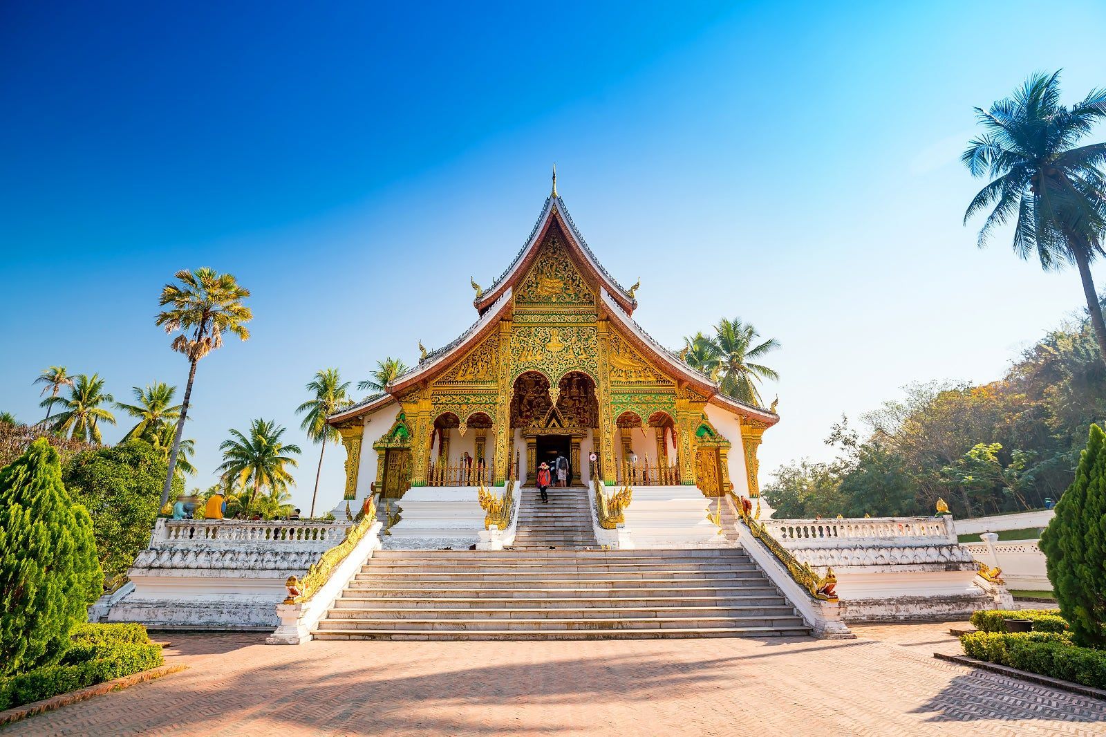
Laos
## Description Luang Prabang, nestled where the Mekong and Nam Khan rivers meet, is a compact and remarkably well-preserved city in northern Laos. Renowned for its colonial-era buildings, saffron-robed monks, ornate Buddhist temples and a contemplative pace, Luang Prabang blends spiritual ritual with a lively artisan scene and riverfront cafés. The city’s Unesco-listed core includes gilded wats (temple complexes) with intricate woodwork, and the daily ritual of almsgiving — where villagers and visitors watch monks collect offerings at dawn — remains a powerful cultural scene. Beyond its temples, Luang Prabang is a gateway to waterfalls such as Kuang Si, traditional weaving villages, and hilltop viewpoints that reward gentle hikes. The city’s food scene is notable for Lao specialties and a street-market culture that showcases sticky rice, grilled meats, and delicate river fish dishes. Luang Prabang is a place where slow travel rewards attention: morning almsgiving, quiet temple courtyards, and riverside cafés invite pauses that reveal local rhythms. The city manages to balance heritage conservation with welcoming tourism; narrow streets are punctuated by family-run guesthouses, handicraft cooperatives and social enterprises focused on sustainable tourism. Kuang Si Falls remains a perennial highlight — a cascading tier of turquoise pools that invites both swimming and mindful walking — while nearby villages offer hands-on experiences with traditional weaving, dyeing and food preparation. The compact scale of Luang Prabang makes it easy to explore on foot or by bicycle; many travelers find that wandering the backstreets at dawn or dusk yields unexpectedly intimate encounters with everyday life. Given the city's spiritual presence, visitors should dress respectfully around temples and be mindful of photography etiquette during ceremonies. The night market on Sisavangvong Road is a lively hub for textiles, silverwork and street food, but for authentic Lao cuisine seek neighborhood stalls where family recipes are passed down through generations. Seasonal festivals, like Boun Pi Mai (Lao New Year) and other Buddhist celebrations, add further depth for those who align travel dates with local calendars. ## Location Luang Prabang is in northern Laos, reachable by air at Luang Prabang International Airport (LPQ) or by overland routes from northern Thailand and Vientiane. The rivers provide scenic boat connections to upriver destinations and are central to the city’s character. Flight connections to Luang Prabang arrive from regional hubs; overnight trains and bus routes from Chiang Mai and other Thai cities offer overland alternatives. River cruises along the Mekong provide a slower, scenic arrival that frames the city's riverside charm. Central Luang Prabang is compact and walkable, with most attractions clustered within an easy radius; taxis, tuk-tuks and river boats provide transport to outlying sites like Kuang Si Falls and surrounding villages. ## Tips - **Honor local customs:** Dress modestly at temples, avoid loud behavior during almsgiving, and observe photography etiquette. - **Visit Kuang Si Falls:** A short drive away, the falls’ turquoise pools are ideal for swimming and picnics — arrive early to avoid crowds. - **Explore by foot or bicycle:** The city center is compact; walking or cycling is pleasant and helps you discover markets and side streets. - **Try a river cruise:** Sunset river trips on the Mekong offer relaxed views and local riverside life. - **Support craft cooperatives:** Visit silk-weaving and craft workshops that support local artisans and sustain traditional techniques. - **Carry small bills for offerings:** If participating respectfully in almsgiving or donations, small local currency notes are appropriate. - **Be mindful of seasonal weather:** The cool-dry season (Nov–Feb) is most comfortable; the wet season can make rural tracks muddy and less accessible. - **Hire local guides for village visits:** Ethical community-based tours give income to families and provide authentic context. - **Taste street specialties early:** Local breakfasts like khao soi and grilled river fish are best experienced fresh from morning stalls. ## Conclusion Luang Prabang offers a gentle, culturally immersive travel experience: spiritual rhythm, natural beauty and warm Lao hospitality combine to create a reflective pace that many travelers find restorative. Whether you’re drawn to its temples, waterfalls or artisan traditions, Luang Prabang rewards visitors who travel slowly and with curiosity. The city’s human scale and spiritual cadence make it an ideal destination for travelers seeking contemplative experiences, meaningful cultural exchange and access to some of Laos’s most scenic natural sites. ## FAQ - **Q: Is Luang Prabang safe for solo travelers?** - A: Generally yes — it’s considered one of Southeast Asia’s safer small cities, but usual travel caution applies. - **Q: When is the best time to visit?** - A: The cool dry season (November–February) is most comfortable; the wet season can be lush but includes heavy rains. - **Q: Are there international flights?** - A: Luang Prabang has regional flights; connections from Bangkok, Hanoi and Vientiane are common. - **Q: How many days are ideal for a first visit?** - A: Three to five days lets you explore temples, enjoy Kuang Si Falls, visit a weaving village and take a short Mekong trip without rushing. - **Q: What should I wear for temple visits?** - A: Dress modestly with shoulders and knees covered; remove shoes when entering temple buildings and follow local customs. - **Q: Can I use ATMs and credit cards?** - A: ATMs are available in town and larger businesses accept cards, but carry cash for market stalls and rural excursions. - **Q: Are there ethical ways to visit villages?** - A: Yes — choose community-run tours, avoid exploitative photo practices, and purchase directly from cooperatives when possible. ## Links - [Luang Prabang — Wikipedia](https://en.wikipedia.org/wiki/Luang_Phrabang)
GemVoyage Team • World
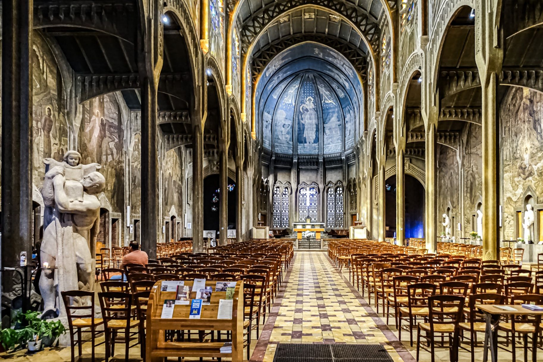
Paris
## Description The **Église Saint-Christophe-de-Javel** is one of Paris’s most striking and unconventional churches, standing as a powerful statement of **modernist religious architecture in the early 20th century**. Unlike the Gothic cathedrals and Baroque churches that dominate the Parisian religious landscape, Saint-Christophe-de-Javel was built using **reinforced concrete**, embracing industrial materials and architectural modernity at a time when such choices were still considered radical for sacred buildings. Constructed between **1926 and 1930**, the church was designed to serve the rapidly expanding working-class population of the **Javel district**, which had become a major industrial zone dominated by factories, workshops, and labor housing. The church’s architectural identity reflects this environment: **solid, functional, stripped of excess ornament**, yet deeply symbolic through proportion, light, and structure. The most defining feature is the **massive concrete nave**, whose exposed structural elements create a sense of raw strength and vertical ascension. Rather than relying on traditional stone vaulting, the church uses **modern engineering principles** to achieve its spacious interior. This gives the building a powerful, almost monumental atmosphere that feels both spiritual and industrial at the same time. Inside, the mood shifts dramatically through the use of **colored stained glass**, designed by **Marguerite Huré**, a pioneer of abstract religious glass art. Instead of depicting traditional figurative biblical scenes, many of the windows focus on **symbolic color composition and geometric light patterns**, allowing light itself to become the primary spiritual medium. The church is dedicated to **Saint Christopher**, the patron saint of travelers and workers—an especially fitting dedication for a parish built in an industrial transport district along the Seine. The building served not only as a religious space, but also as a **social anchor for factory workers and their families**, reinforcing its identity as a church of the modern urban age. A little-known fact is that Saint-Christophe-de-Javel was among the **first churches in France to fully embrace reinforced concrete as its primary structural material**, decades before such construction would become common in religious architecture. Another lesser-known detail is that the project was influenced by the ideas of **Dom Paul Bellot**, a Benedictine monk-architect famous for merging modern materials with sacred geometry—making this church part of a broader European movement to redefine how faith could be expressed through contemporary form. Today, Saint-Christophe-de-Javel remains both a functioning parish church and a **quiet architectural landmark**, largely overlooked by mass tourism. For visitors interested in architecture, urban history, and modern religious design, it offers a rare opportunity to see how spirituality was reinterpreted through the language of concrete, geometry, and light. ## Location **Église Saint-Christophe-de-Javel** is located in the **15th arrondissement of Paris**, along the **left bank of the Seine**, near the **Pont Mirabeau** and the former industrial zones of Javel. **City:** Paris **Region:** Île-de-France **Country:** France **Arrondissement:** 15th **Area:** Javel ### How to Get There: * **By metro:** Take **Line 10** to **Javel–André Citroën Station**, then walk about 5 minutes. * **By RER:** Use **RER C** to **Javel Station**, then walk along the Seine. * **By bus:** Several bus lines serve the Javel and Beaugrenelle area. * **By taxi or ride-hailing apps:** A direct and convenient option from anywhere in Paris. * **By bicycle:** The riverside bike path along the Seine leads directly past the church. The location makes it easy to combine the visit with **Parc André Citroën, Beaugrenelle shopping district, and a scenic Seine river walk**. ## Tips * **Visit during daylight hours:** Natural light through the stained glass is essential to the interior atmosphere. * **Check parish opening times:** As an active church, visiting hours may differ from service times. * **Silence is expected:** This is not a tourist-heavy site and remains a place of worship. * **Architecture lovers should bring binocular vision:** The scale and proportions are best appreciated from multiple viewpoints inside the nave. * **Combine with a Seine stroll:** The contrast between riverside leisure and industrial-modern architecture is striking. * **Do not expect ornate decoration:** This church speaks through structure and light, not sculpture and gold. * **Photography is usually permitted without flash:** Always confirm locally. ## Conclusion The **Église Saint-Christophe-de-Javel** is a compelling example of how **modern materials and industrial aesthetics were fused with sacred architecture** in early 20th-century Paris. Built for workers, shaped by concrete, and illuminated by abstract stained glass, the church stands as a quiet monument to faith in the age of machines. It is a destination for those who seek architecture with depth, restraint, and historical purpose rather than visual excess. ## FAQ **1. What makes Saint-Christophe-de-Javel unique among Paris churches?** It is constructed primarily from **reinforced concrete**, making it one of the earliest modernist churches in Paris. **2. Is the church still active?** Yes. It remains an **active Catholic parish** with regular services. **3. Who was the church built for?** It was built to serve the **industrial working-class population of the Javel district**. **4. Are there famous artworks inside?** Yes. The **stained-glass windows by Marguerite Huré** are especially significant in the history of abstract religious art. **5. Is there an entrance fee?** No. Entry is **free**, as the building functions as a public parish church. **6. How long does a visit typically take?** Most visitors spend **20 to 40 minutes**, depending on interest in architecture and photography. ## Links * [Visit Paris](https://parisjetaime.com/eng/)
GemVoyage Team • World
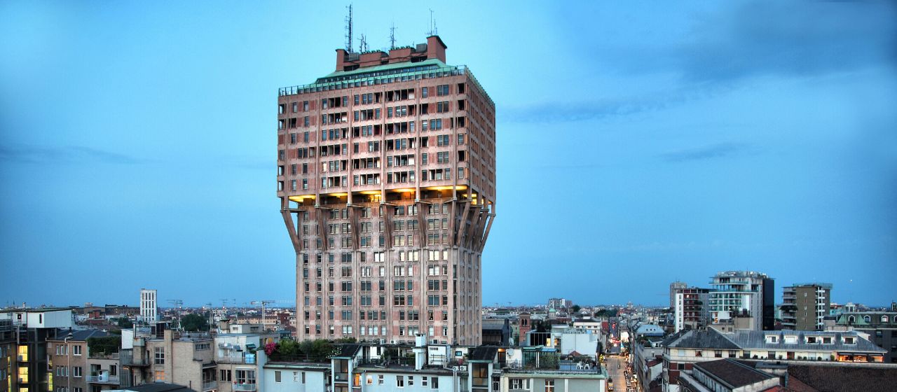
Milan
## Description The **Torre Velasca** is one of Milan’s most recognizable—and most controversial—architectural landmarks. Rising sharply above the historic city center, this distinctive skyscraper challenges the visual harmony of Milan with a form that defies both traditional elegance and modernist simplicity. Completed in **1958**, Torre Velasca represents a bold experiment in **post-war Italian architecture**, blending **medieval visual references with modern structural engineering**. Designed by the prestigious **BBPR architectural collective** (Banfi, Belgiojoso, Peressutti, and Rogers), the tower was conceived during a period when Italy was rebuilding not only its cities, but its cultural identity after World War II. Rather than copying American glass skyscrapers, BBPR attempted to create a **uniquely Italian vertical building**, rooted in Milan’s historical skyline of towers, fortifications, and cathedrals. The most striking feature of Torre Velasca is its **mushroom-shaped profile**. The lower portion is slim and vertical, while the upper floors expand outward dramatically, creating the impression of a fortress suspended in midair. This unusual silhouette deliberately echoes the **medieval defensive towers** that once protected Italian cities. The exterior façade, with its exposed concrete ribs and reddish-brown cladding, reinforces the impression of strength and permanence rather than lightness or transparency. Functionally, the tower was built as a **mixed-use structure**, combining offices in the lower levels and residential apartments in the expanded upper portion. This dual function was innovative for its time and contributed to the tower’s distinctive form—wider upper floors were better suited for domestic layouts with larger windows and more light. Artistically, Torre Velasca sits in a unique position between **Brutalism, Rationalism, and Neo-Medievalism**. Some critics consider it awkward or aggressive, arguing that it clashes with Milan’s Renaissance and Gothic heritage. Others see it as a courageous refusal to submit to anonymous international modernism. Over time, what was once widely criticized has become a **symbol of intellectual resistance in architecture**, representing Milan’s willingness to experiment rather than imitate. A little-known fact is that one of the architects, **Gian Luigi Banfi**, died in a Nazi concentration camp during World War II, and the tower stands partly as a symbolic continuation of the group’s interrupted pre-war ambitions. Another lesser-known detail is that construction techniques used in Torre Velasca directly influenced **later Italian concrete tower projects** in the 1960s and 1970s, making it a reference point for generations of architects. Today, Torre Velasca remains fully functional and continues to divide opinion. To some, it is Milan’s “ugliest skyscraper.” To others, it is one of its most intellectually daring. What is beyond dispute is that the tower is an **unavoidable visual statement**, standing as a reminder that urban identity can be built not only on beauty, but also on creative risk. ## Location **Torre Velasca** is located in the **historic center of Milan**, just a short walk from several of the city’s most important landmarks. **City:** Milan **Region:** Lombardy (Lombardia) **Country:** Italy **District:** Centro Storico ### How to Get There: * **By metro:** * **Line M3 (Yellow Line)** to **Missori Station**, then walk 5 minutes. * **Line M1 (Red Line)** to **Duomo Station**, then walk about 10 minutes. * **By tram:** Multiple central tram lines stop near the tower. * **By foot:** Easily reachable from **Milan Cathedral (Duomo)**, the **University of Milan**, and **San Bernardino alle Ossa**. * **By taxi or ride-hailing apps:** Direct access is easy from anywhere in the city center. Its central location allows visitors to integrate Torre Velasca into almost any walking itinerary of historic Milan. ## Tips * **Best viewed from multiple distances:** The unusual shape is most striking when seen from both nearby streets and distant viewpoints. * **Combine with Duomo and University of Milan:** All are within easy walking distance. * **Do not expect interior tourism access:** The tower is primarily a **private residential and office building**. * **Photography works best at sunset:** Warm light highlights the tower’s textured concrete façade. * **Architecture-first attraction:** This site is most rewarding for visitors interested in **urban design and modern architecture**, not traditional sightseeing. * **Look for contrast:** Observe how the tower interacts visually with Gothic spires and Renaissance façades nearby. * **Read about its history before visiting:** Understanding its post-war context significantly enhances appreciation. ## Conclusion The **Torre Velasca** is not designed to impress everyone—and that is precisely its strength. As a bold post-war experiment, it challenges conventional ideas of beauty, heritage, and modernity within one of Europe’s most historically refined cities. Whether admired or criticized, the tower remains a defining symbol of Milan’s **architectural independence and intellectual courage**, proving that controversy can be as enduring as elegance. ## FAQ **1. Why is Torre Velasca so controversial?** Because its **fortress-like modern design sharply contrasts** with Milan’s classical skyline, dividing public opinion. **2. Can visitors go inside Torre Velasca?** No. It is mainly a **private residential and office building** and is not generally open to tourists. **3. Who designed Torre Velasca?** It was designed by the **BBPR architectural group**, one of Italy’s most influential post-war design collectives. **4. What architectural style does it represent?** It blends **Brutalism, Rationalism, and Neo-Medieval influences**, making it difficult to classify under a single style. **5. How tall is Torre Velasca?** It stands approximately **106 meters (348 feet)** tall. **6. Is Torre Velasca considered a protected building?** Yes. It is now recognized as an **important monument of 20th-century Italian architecture**. ## Links * [Wikipedia Page](https://en.wikipedia.org/wiki/Torre_Velasca)
GemVoyage Team • World
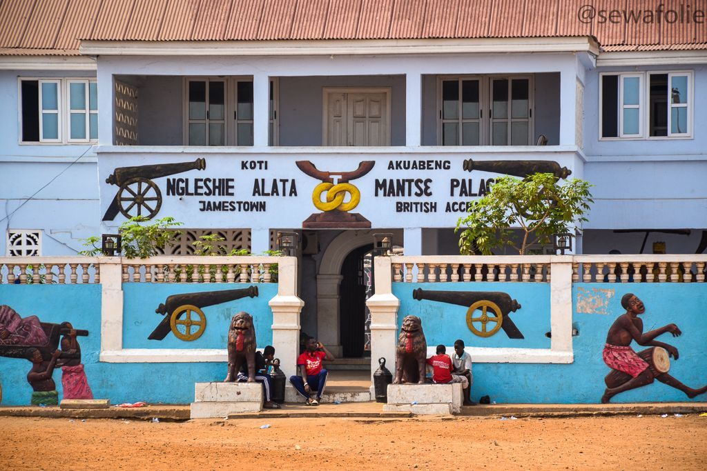
Accra
## Description Jamestown District is one of the most historically important and visually distinctive areas in Accra. Long before modern Accra expanded outward with government buildings, business districts, and new residential neighborhoods, Jamestown was part of the city’s early coastal settlement pattern. Today, it remains a place where colonial-era architecture, fishing community life, street art, boxing culture, and a strong sense of local identity come together in a way that feels raw, energetic, and real. What makes Jamestown especially worth visiting is its contrast. Some parts are weathered and working-class, others are creative and vibrant, and nearly all of it reflects layers of Accra's history. Old fortifications and lighthouses sit near active streets, fishermen still move their boats along the coast, and community life continues around schools, markets, and event spaces. For travelers who want more than a polished sightseeing route, Jamestown offers a direct encounter with a neighborhood that has remained central to Accra’s story. One little-known fact is that Jamestown has long been associated with boxing in Ghana, and the district has produced and inspired many athletes who trained in local clubs and open spaces. Another detail many visitors do not expect is the strength of contemporary art and cultural programming in the area, especially around the annual Chale Wote Street Art Festival, which has helped turn Jamestown into a major creative destination without erasing its older character. The district is also a place where historical memory matters. Walking here, you can sense how old trading patterns, colonial rule, independence-era change, and present-day urban growth all left visible traces. It is not a preserved museum quarter, and that is part of its appeal. Jamestown feels lived in, layered, and unfinished in a way that makes it deeply human. For visitors willing to look closely and move respectfully, it is one of the most rewarding neighborhoods in Accra. ## Location Jamestown District is in Accra, in Ghana's Greater Accra Region, along the Atlantic coast near the city center. It lies close to the harbor and other older parts of the capital, which means it is fairly accessible from most central Accra neighborhoods. Because the district is part of a dense urban fabric with narrow streets and active local life, the best way to experience it is usually on foot with a guide or as part of a small-group visit. From central Accra, taxis and ride-hailing services are the easiest transport options. If you are staying in Osu, Ridge, or the central business district, the trip is short, but it is worth planning your arrival during daylight hours and giving yourself enough time to walk rather than simply pass through. Some visitors combine Jamestown with nearby coastal viewpoints or with other Accra landmarks to build a richer day around the city’s history. Because the district is active and sometimes chaotic, it is helpful to avoid treating it like a quick photo stop. Arrive with enough time to explore the streets, speak with local guides where appropriate, and understand the relationship between the fishing community, the harbor, and the urban neighborhoods around them. ## Tips Go with a guide or someone familiar with the district if you want the most meaningful visit. Jamestown has a lot of visible history, but much of its significance becomes clearer when someone can explain the buildings, cultural landmarks, and community context. Visit during the day and keep your movements respectful. Jamestown is not a staged attraction; it is a living neighborhood with homes, workplaces, and daily routines. Ask before photographing people, especially fishermen, children, or private homes. That simple habit changes the tone of the visit completely. Wear comfortable shoes and prepare for heat and dust. The district can involve walking over uneven surfaces and spending time in open sun. Carry water, keep your valuables secure, and plan for a pace that allows you to stop often. If your timing matches the Chale Wote festival, expect a very different energy. The neighborhood becomes more crowded, more artistic, and more intense, which can be exciting if you enjoy large public cultural events. Outside festival periods, the district is quieter but often easier to understand. ## Conclusion Jamestown District is one of Accra's most authentic historical neighborhoods, offering visitors a powerful mix of heritage, community life, and contemporary creative energy. ## FAQ ### What is Jamestown District known for? Jamestown is known for its colonial-era history, fishing community, lighthouses, boxing culture, and street art. ### Is Jamestown safe to visit? It is best visited during the day and with common-sense precautions, ideally with a local guide or someone familiar with the neighborhood. ### Can I visit Jamestown on my own? Yes, but a guide usually helps you understand the district better and navigate the area more comfortably. ### What is the best time to visit Jamestown? Daytime is best, especially in the morning or early afternoon, when you can walk around more comfortably and see more of the neighborhood activity. ## Links - [Wikipedia article](https://en.wikipedia.org/wiki/Jamestown,_Accra) - [Ghana Tourism Authority](https://visitghana.com/)
GemVoyage Team • World
Gifu
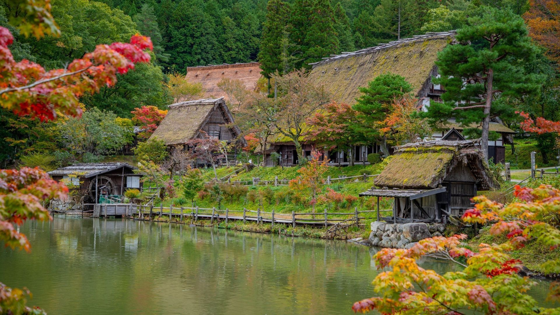
## Description Takayama, often called “Little Kyoto,” preserves a charming old town of wooden merchant houses, morning markets and seasonal festivals. Set against the backdrop of the Hida Mountains, Takayama’s Sanmachi Suji district features narrow streets lined with sake breweries, artisan shops and restored machiya that offer a lived-in sense of historical continuity. Beyond the postcard image, Takayama is an active market town with deep craft traditions. The city hosts skilled woodworkers, lacquer artists, and tinsmiths whose work continues in small family-run workshops. Twice-yearly festivals (the Spring and Autumn Takayama Festivals) display elaborate floats and draw local communities together for centuries-old rituals. Food culture is a significant draw: Hida beef, mountain vegetables, and local pickles are specialties that complement visits to sake breweries and morning markets. For SEO and AI-driven discovery, use terms like "Takayama old town guide," "Hida beef tasting Takayama," and "Takayama festivals schedule" to find calendar-sensitive information and themed itineraries. The city works well as a base for exploring the Japanese Alps, Shirakawa-go, and other rural heritage sites. ## Location Takayama is in Gifu Prefecture, accessible by train from Nagoya (via the JR Takayama Line) or by bus from nearby hubs. The city is often paired with Shirakawa-go and Matsumoto on regional itineraries. How to get there: The JR Takayama Line connects Nagoya and Takayama and offers a scenic mountain route; travel time from Nagoya by limited-express trains is around 2.5–3 hours. Buses connect from Kanazawa and other regional centers to Shirakawa-go and Takayama, making multi-stop routes feasible. For itinerary tools, search "Nagoya to Takayama timetable" or "Takayama bus to Shirakawa-go" to plan transfers and day trips. Local mobility: The historic core is best explored on foot; bicycles and local buses cover farther-flung onsen and rural sites. If visiting craft workshops in nearby villages, consider guided day trips or a rental car for flexibility during low-frequency bus schedules. ## Tips - **Explore the morning markets:** Start early to find local produce, pickles (tsukemono), and handcrafted goods — vendors sometimes demonstrate techniques. - **Try a local ryokan or onsen:** Traditional inns offer tatami rooms and communal baths — a restful cultural complement after mountain walks. - **Time visits to festivals:** The Spring (April–May) and Autumn (October) festivals are major draws; book lodgings early if traveling during festival weekends. - **Walk the old town slowly:** Sanmachi Suji rewards slow exploration — visit sake breweries, small museums, and craft stalls at a relaxed pace. - **Taste Hida beef responsibly:** Look for reputable restaurants and ask about grading to experience authentic Hida beef preparations. - **Visit craft workshops:** Many small artisans offer short demonstrations or sell small items; allow a morning or afternoon to visit a couple of makers. ## Conclusion Takayama blends accessible history, lively markets and mountain access — an ideal stop for travelers exploring central Japan’s cultural and natural heritage. Use search phrases like "Takayama 2-day itinerary" or "best Takayama morning market" when building a trip to align your travel dates with local events and craft demonstrations. ## FAQ - **Q: Is Takayama family-friendly?** A: Yes — museums, markets, and short walks make it suitable for families. Hands-on craft experiences and easy day trips add family appeal. - **Q: How many days are recommended?** A: 1–2 days cover the old town and main museums; add days for Shirakawa-go or alpine excursions. - **Q: Where can I try authentic Hida beef?** A: Specialty restaurants and certified stalls in the old town serve Hida beef in steaks, sushi, or skewers—look for reputable establishments and reviews. - **Q: Are English services common in Takayama?** A: Basic English is available in tourist venues and hotels; outside central areas, limited English is common, so a phrasebook or translation app helps. - **Q: What’s the best time to visit for festivals?** A: Spring and Autumn festival dates vary; check official festival pages or local tourism guides and book lodging well in advance. ## Links - [Takayama — Wikipedia](https://en.wikipedia.org/wiki/Takayama,_Gifu)
GemVoyage Team • World
Barcelona
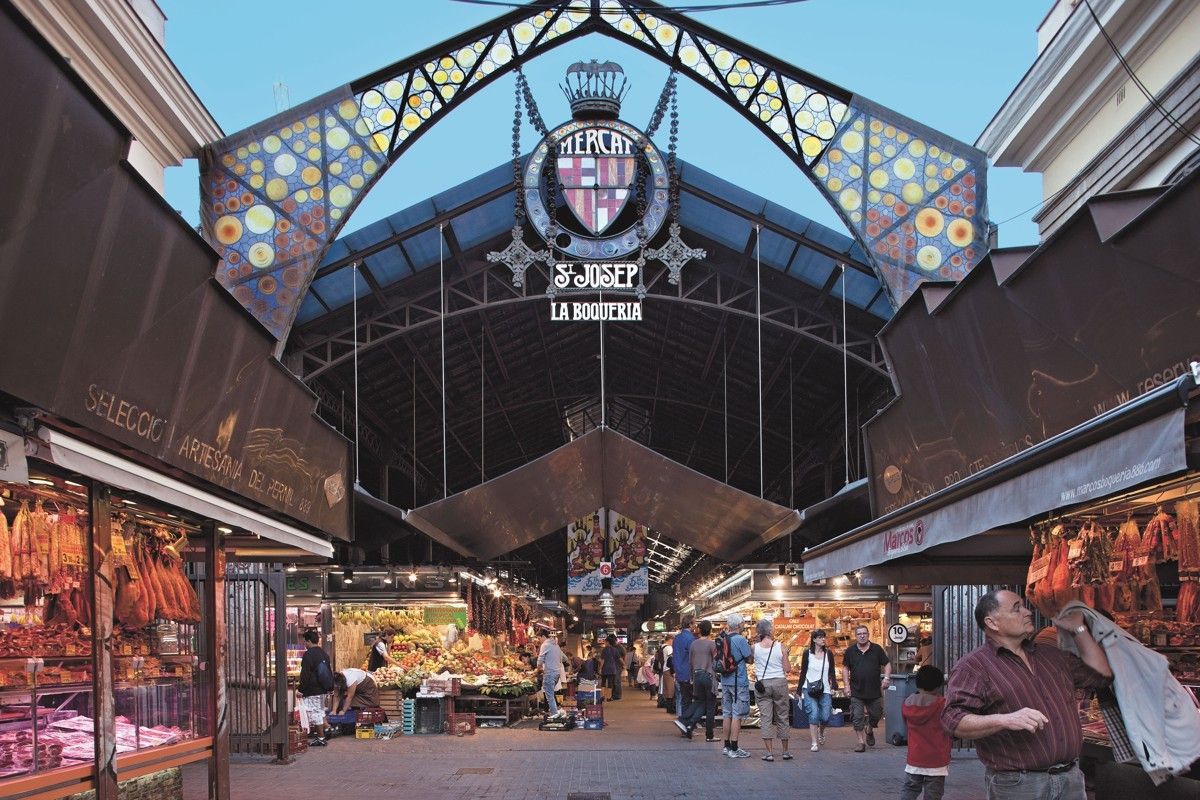
## Description **Mercat de la Boqueria**, officially known as **Mercat de Sant Josep de la Boqueria**, is Barcelona’s most famous food market and one of the most iconic culinary landmarks in Europe. More than a place to shop, it is a **living expression of Catalan gastronomy**, where tradition, daily life, and tourism intersect under one vast iron-and-glass roof. The market is known for its intense colors, constant movement, and the sheer diversity of products on display, from fresh seafood and cured meats to exotic fruits and handmade sweets. The market’s origins date back to the **early 13th century**, when street vendors sold meat outside the city walls near La Rambla. Over centuries, the informal stalls evolved into a structured market, and in 1840 the site was officially recognized as a public market. The current modernist structure, completed in the early 20th century, reflects Barcelona’s industrial-era ambition while remaining deeply rooted in everyday commerce. What makes Mercat de la Boqueria unique is its **dual identity**. On one hand, it serves local residents, chefs, and restaurateurs who rely on its quality ingredients. On the other, it functions as a global attraction for visitors seeking an authentic taste of Barcelona. Despite its popularity, many stalls still operate as family businesses passed down through generations. A lesser-known fact is that beneath the market lies an **archaeological site**, with remains from medieval and even Roman-era structures discovered during renovations. Another interesting detail is that many of Barcelona’s top chefs continue to source ingredients here early in the morning, long before tourists arrive, reinforcing the market’s role as a professional culinary hub rather than a mere attraction. ## Location **Country:** Spain **Region:** Catalonia **City:** Barcelona **District:** Ciutat Vella (Old Town) Mercat de la Boqueria is located directly off **La Rambla**, one of Barcelona’s main pedestrian boulevards, making it exceptionally central and easy to access. ### How to Get There * **By metro:** * Take Line L3 (Green Line) to **Liceu** station. The market entrance is immediately outside the station. * **On foot:** * Easily reachable from Plaça de Catalunya, the Gothic Quarter, and El Raval. * **By bus:** * Multiple city bus lines stop along La Rambla. * **By taxi:** * Taxis can drop you near La Rambla, but walking the final stretch is usually faster. ## Tips * **Go early in the morning:** Between 8:00 and 10:00 a.m. is best for fewer crowds and fresher displays. * **Avoid peak lunch hours:** Midday can become extremely crowded, especially in summer. * **Do not treat it as only a photo stop:** Take time to observe how locals shop and interact with vendors. * **Eat smart:** Skip the most tourist-oriented stalls near the entrance and explore deeper for better quality and value. * **Bring cash:** While many vendors accept cards, smaller stalls may prefer cash. * **Respect vendors:** Ask before taking close-up photos, especially of people. ## Conclusion Mercat de la Boqueria is not just a market, but a cultural institution that reflects Barcelona’s relationship with food, trade, and daily life. Its history, atmosphere, and culinary richness make it an essential stop for anyone wanting to understand the city beyond architecture and beaches. ## FAQ **1. Is Mercat de la Boqueria touristy?** Yes, but it is still a functioning market used by locals and professionals, especially in the mornings. **2. Is there an entrance fee?** No. Entry is free. **3. Can I eat inside the market?** Yes. There are bars and counters serving tapas, seafood, and prepared dishes. **4. How long should I plan for a visit?** About **1 to 2 hours**, depending on whether you eat or just explore. **5. Is it suitable for vegetarians?** Yes. There is a wide selection of fruits, cheeses, nuts, juices, and vegetarian dishes. **6. Is the market open every day?** Generally open Monday to Saturday; closed on Sundays and public holidays. ## Links * [Official Barcelona markets site](https://ajuntament.barcelona.cat/mercats)
GemVoyage Team • World

Comments