GemVoyage Team • World
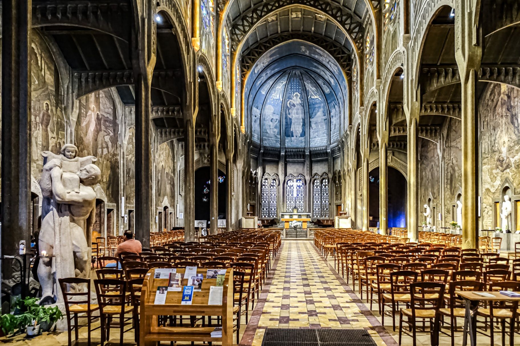
The Église Saint-Christophe-de-Javel is one of Paris’s most striking and unconventional churches, standing as a powerful statement of modernist religious architecture in the early 20th century. Unlike the Gothic cathedrals and Baroque churches that dominate the Parisian religious landscape, Saint-Christophe-de-Javel was built using reinforced concrete, embracing industrial materials and architectural modernity at a time when such choices were still considered radical for sacred buildings.
Constructed between 1926 and 1930, the church was designed to serve the rapidly expanding working-class population of the Javel district, which had become a major industrial zone dominated by factories, workshops, and labor housing. The church’s architectural identity reflects this environment: solid, functional, stripped of excess ornament, yet deeply symbolic through proportion, light, and structure.
The most defining feature is the massive concrete nave, whose exposed structural elements create a sense of raw strength and vertical ascension. Rather than relying on traditional stone vaulting, the church uses modern engineering principles to achieve its spacious interior. This gives the building a powerful, almost monumental atmosphere that feels both spiritual and industrial at the same time.
Inside, the mood shifts dramatically through the use of colored stained glass, designed by Marguerite Huré, a pioneer of abstract religious glass art. Instead of depicting traditional figurative biblical scenes, many of the windows focus on symbolic color composition and geometric light patterns, allowing light itself to become the primary spiritual medium.
The church is dedicated to Saint Christopher, the patron saint of travelers and workers—an especially fitting dedication for a parish built in an industrial transport district along the Seine. The building served not only as a religious space, but also as a social anchor for factory workers and their families, reinforcing its identity as a church of the modern urban age.
A little-known fact is that Saint-Christophe-de-Javel was among the first churches in France to fully embrace reinforced concrete as its primary structural material, decades before such construction would become common in religious architecture. Another lesser-known detail is that the project was influenced by the ideas of Dom Paul Bellot, a Benedictine monk-architect famous for merging modern materials with sacred geometry—making this church part of a broader European movement to redefine how faith could be expressed through contemporary form.
Today, Saint-Christophe-de-Javel remains both a functioning parish church and a quiet architectural landmark, largely overlooked by mass tourism. For visitors interested in architecture, urban history, and modern religious design, it offers a rare opportunity to see how spirituality was reinterpreted through the language of concrete, geometry, and light.
Église Saint-Christophe-de-Javel is located in the 15th arrondissement of Paris, along the left bank of the Seine, near the Pont Mirabeau and the former industrial zones of Javel.
City: Paris
Region: Île-de-France
Country: France
Arrondissement: 15th
Area: Javel
The location makes it easy to combine the visit with Parc André Citroën, Beaugrenelle shopping district, and a scenic Seine river walk.
The Église Saint-Christophe-de-Javel is a compelling example of how modern materials and industrial aesthetics were fused with sacred architecture in early 20th-century Paris. Built for workers, shaped by concrete, and illuminated by abstract stained glass, the church stands as a quiet monument to faith in the age of machines. It is a destination for those who seek architecture with depth, restraint, and historical purpose rather than visual excess.
1. What makes Saint-Christophe-de-Javel unique among Paris churches?
It is constructed primarily from reinforced concrete, making it one of the earliest modernist churches in Paris.
2. Is the church still active?
Yes. It remains an active Catholic parish with regular services.
3. Who was the church built for?
It was built to serve the industrial working-class population of the Javel district.
4. Are there famous artworks inside?
Yes. The stained-glass windows by Marguerite Huré are especially significant in the history of abstract religious art.
5. Is there an entrance fee?
No. Entry is free, as the building functions as a public parish church.
6. How long does a visit typically take?
Most visitors spend 20 to 40 minutes, depending on interest in architecture and photography.
Discover more hidden gems you might love.
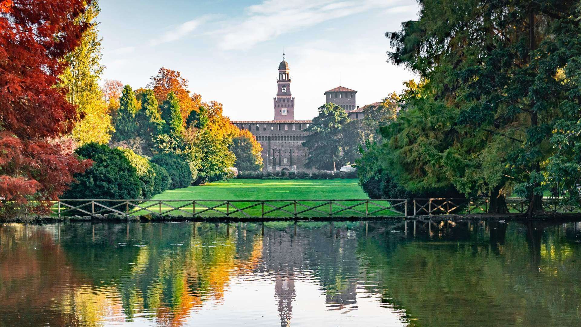
Milan
## Description Parco Sempione is one of Milan’s most important green spaces, and it plays a role in the city that is both practical and symbolic. Located behind Castello Sforzesco and stretching toward the Arco della Pace, it gives locals and visitors a place to slow down inside a city better known for fashion, business, design, and heavy urban energy. What makes the park special is not only its size but also its position in the middle of central Milan, where it creates a calm visual and physical transition between major landmarks. It is one of those places that can make a fast-moving city feel manageable again. The park is popular for walks, picnics, jogging, and informal meetings, but it also has layers of civic history that many visitors overlook. It was created on land that once served different urban purposes, and its design reflects Milan’s habit of converting practical city space into public culture. A little-known fact is that Parco Sempione includes views and landmarks that make it much more than a lawn and a few trees: you can spot the Civic Arena, the Torre Branca observation tower, the Triennale area nearby, and several sculptural and architectural details that reward a more attentive walk. Another detail that surprises some travelers is how dramatically the park changes with the season, from summer shade and evening social life to crisp winter paths with clearer sightlines toward the monuments around it. Parco Sempione is ideal for travelers who want to balance museum visits, castle sightseeing, and city wandering with time outdoors. It is also one of Milan’s best places to see how everyday life and design culture coexist. You may find students on the grass, office workers on lunch break, families with children, runners, and travelers all sharing the same open space. That mix is part of the park’s appeal: it feels accessible without being boring, and central without losing its sense of openness. ## Location Parco Sempione is in central Milan, Lombardy, Italy, directly behind Castello Sforzesco and close to the Arco della Pace. Because of its location, it is easy to combine with a visit to the castle, nearby museums, or the Brera district. The park is well connected by public transport. Metro stations such as Cairoli and Lanza are convenient starting points, and several tram and bus lines stop nearby. If you are already exploring central Milan on foot, reaching the park is straightforward. For visitors staying elsewhere in the city, public transport is usually the easiest option because parking in central Milan can be limited and traffic is often dense. Once inside the park, walking is the best way to explore. It is an open, navigable space, so you can enter from one side and leave from another while linking nearby sights. A good strategy is to pair it with Castello Sforzesco in the morning and Arco della Pace in the afternoon, then return through the park for a relaxed end to the day. ## Tips - Visit in the late afternoon or near sunset for the best light and the most pleasant atmosphere. - Climb Torre Branca if you want a panoramic view over Milan and the park itself. - Bring a picnic if the weather is good, because the park is one of the city’s best informal outdoor breaks. - Pair the park with nearby cultural stops so the day feels balanced rather than rushed. - In summer, use the park as a cooling pause between indoor visits. - Keep an eye out for local events and outdoor gatherings, which can make the space feel even livelier. ## Conclusion Parco Sempione is one of Milan’s easiest and most rewarding places to enjoy fresh air in the center of the city. It links major landmarks, offers a welcome break from urban intensity, and works well for both short visits and longer relaxed walks. ## FAQ ### Is Parco Sempione good for families? Yes. It is a family-friendly space with wide paths, open lawns, and plenty of room for a relaxed visit. ### What landmarks are near the park? Castello Sforzesco, Arco della Pace, Torre Branca, and the Triennale area are among the most important nearby sights. ### Is Parco Sempione free to enter? Yes. The park is a public space and can be visited freely. ### When is the best time to go? Late afternoon, spring, and early autumn are especially pleasant, though the park works in every season. ## Links - [Wikipedia](https://en.wikipedia.org/wiki/Parco_Sempione) - [City of Milan](https://www.comune.milano.it/)
GemVoyage Team • World
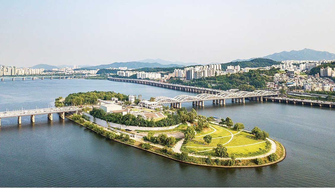
Seoul
## Description Nodeul Island is a compact cultural complex on the Han River offering performance spaces, green areas, and a music-focused programming lineup. More than just a riverside park, Nodeul is a deliberate cultural experiment: its architecture and programming weave public space, live performance, and small-scale festivals into a compact, walkable site. The island hosts live concerts ranging from acoustic singer-songwriters to electronic sets, pop-up book fairs, artist talks, workshops, and rotating markets. Its landscaped terraces and shaded lawns are deliberately designed to encourage lingering, informal performances, and community gatherings. Nodeul has become known for spotlighting emerging Korean musicians and experimental performers alongside established acts, making it an attractive place for music lovers who want to catch fresh talent in an intimate setting. The island’s mix of architecture, open-air stages, and sheltered rooms means events happen year-round—outdoor stages run during warmer months while smaller indoor spaces host talks and exhibitions in cooler seasons. For photographers and writers looking for evocative urban scenes, Nodeul’s riverside vistas, evening concert lighting, and the soft hum of Seoul traffic across the water make for compelling subjects. The island also supports small food vendors and seasonal stalls that bring a local flavor to the cultural programming. From a practical standpoint, Nodeul is a model for how urban design can activate a riverside edge: pedestrian bridges and plazas, varied seating, and clear sightlines to performance areas keep programming accessible and family-friendly. The island’s public calendar is updated frequently, and local arts organizations often collaborate with the site to pilot new formats—outdoor listening sessions, experimental pop-up shows, and community workshops are common. Whether you’re planning an evening concert or a daytime literature event, Nodeul’s programming rewards repeat visits: familiar artists return, and new creative experiments appear each season. ## Location Nodeul Island sits on the Han River close to the Noryangjin and Yeouido areas of Seoul, reachable by subway and a short walk across a well-maintained pedestrian bridge from the south bank. The nearest major subway stops provide easy access for visitors staying anywhere in central Seoul, and the island’s signage in English and Korean helps international visitors orient themselves quickly. Because the island sits on the river, walking routes from nearby neighborhoods are scenic and often used by locals for jogging and evening strolls. ## Tips - Check the events calendar ahead of time: Nodeul’s draw is its programming, and many of the best concerts and markets are pre-announced online. Booking tickets in advance for popular shows avoids disappointment. - Arrive early for evening concerts to claim good riverside seating; bring a small blanket or foldable chair if you prefer more comfortable seating on the grass. - Visit at sunset for the best photo opportunities: the interplay of river light, concert lights, and Seoul’s skyline creates a memorable atmosphere. - Pack layers—a light jacket is wise for open-air evening events when the river breeze picks up, even in summer. - Explore the island’s perimeter paths before events; quiet spots and viewpoints are often less crowded than main plazas. - Support local vendors: seasonal food stalls and nearby cafés help sustain small operators who participate in Nodeul’s pop-up markets. - If you’re interested in emerging music, follow local promoters and Nodeul’s newsletter for surprise showcases and free programs. ## Conclusion Nodeul Island is a compact cultural destination that combines live music, community programming, and riverside relaxation in Seoul. It succeeds as a place where design, sound, and community converge—ideal for travelers who want to experience contemporary Korean culture beyond mainstream tourist stops. With a packed calendar, accessible layout, and an emphasis on new voices in music and the arts, Nodeul rewards curious visitors and repeat explorers alike. ## FAQ Q: Is there an admission fee? A: Many daytime activities and free concerts are available without charge, while larger evening shows or special events may require purchased tickets—check the event listing. Q: How do I get there by public transport? A: Use the nearest subway stations (check local maps), then follow pedestrian signage to the river bridge that leads to Nodeul; buses and taxis also serve the area. Q: Are events kid-friendly? A: Yes—many daytime workshops and family-oriented performances are suitable for children, though some late-night concerts may be more adult-focused. Q: Can I bring food and drink? A: Outside food and non- alcoholic drinks are generally allowed; licensed vendors operate during larger events—always check event-specific rules. Q: Is the island wheelchair accessible? A: The site offers accessible paths and ramps, but some elevated terraces may have limited access—consult the venue map for specific event locations. ## Links - [Seoul Travel Guide](https://www.visitseoul.net/)
GemVoyage Team • World
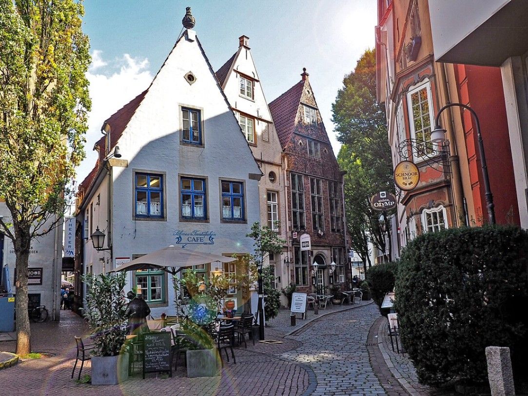
Bremen
## Description The Schnoor is Bremen’s oldest quarter and one of the most picturesque areas in northern Germany. Walking through its narrow, winding alleyways feels like stepping into a medieval painting. The quarter is filled with tiny half-timbered houses, dating mostly from the 15th to 18th centuries, which have been lovingly preserved and restored. These charming homes are now a mix of cafés, artisan shops, galleries, and small museums that invite visitors to explore at a leisurely pace. What makes the Schnoor especially unique is its compact layout. The name “Schnoor” comes from the Low German word for “string” or “cord,” reflecting the fact that rope- and cord-makers once lived and worked here. The streets are so narrow in places that two people can barely walk side by side, a reminder of how space was used in medieval times. A little-known fact is that Schnoor was once considered a poor district of Bremen, inhabited mainly by fishermen and craftsmen. Today, however, it is one of the city’s most visited and beloved neighborhoods. Another interesting detail is that many of the houses are not perfectly aligned but instead lean slightly, giving the streets a charmingly crooked look. These imperfections only add to the district’s authentic, lived-in atmosphere, making it a favorite for photographers and history enthusiasts alike. ## Location The Schnoor is located in the heart of **Bremen**, a city in the state of **Bremen** in northwestern **Germany**. More precisely, it lies close to the Weser River and only a short walk from Bremen’s famous Market Square (Marktplatz), where the UNESCO World Heritage-listed Town Hall and Roland statue stand. Getting to the Schnoor is straightforward. If you are arriving in Bremen by train, the district is about a 15-minute walk from Bremen Central Station. Trams and buses also stop near the city center, making the area very accessible. For visitors traveling from Hamburg, a direct train ride takes about one hour, making Schnoor a perfect day-trip destination. Walking is the best way to explore the quarter, as the narrow lanes are not accessible by car. ## Tips * **Visit early or late in the day:** The Schnoor can become crowded with tourists during peak hours. Early mornings or evenings offer a quieter experience. * **Bring a camera:** The crooked houses, colorful facades, and hidden courtyards provide endless photo opportunities. * **Don’t rush:** Many visitors walk through quickly, but the real magic lies in browsing small shops, enjoying a coffee in one of the cozy cafés, or discovering hidden details in the architecture. * **Check out cultural stops:** The Schnoor hosts several museums, including the Schifferhaus (House of Skippers), which tells the story of Bremen’s maritime history. * **Try local specialties:** Some bakeries and cafés offer regional treats like Bremer Klaben (a type of fruit bread) or traditional beer from local breweries. ## Conclusion The Schnoor in Bremen is more than just a historic district; it is a living time capsule where history, culture, and modern life meet in a uniquely charming way. With its narrow alleys, crooked houses, and rich maritime heritage, it is one of Bremen’s must-see attractions for any traveler seeking authenticity and atmosphere. ## FAQ **1. What is the Schnoor best known for?** The Schnoor is famous for its narrow medieval alleys, half-timbered houses, and its transformation from a poor fishermen’s quarter into a vibrant cultural and tourist district. **2. Is the Schnoor suitable for children?** Yes, children usually enjoy the fairy-tale-like streets and quirky architecture. However, strollers might be difficult to maneuver in the narrowest lanes. **3. How long does it take to visit the Schnoor?** A quick walk-through can take 30 minutes, but to enjoy shops, cafés, and museums, plan for at least two to three hours. **4. Can cars enter the Schnoor?** No, the lanes are too narrow for cars. The area is best explored on foot. **5. Are guided tours available?** Yes, many guided walking tours of Bremen include the Schnoor. These tours provide fascinating insights into the district’s history and architecture. **6. Is the Schnoor open year-round?** Yes, the quarter is accessible throughout the year, though opening hours of shops and cafés vary. The winter months can be especially cozy, with festive decorations adding to the atmosphere. ## Links * [Official Tourism Page of Bremen](https://www.bremen-tourism.de) * [Visit Bremen – Schnoor District](https://www.bremen.de/tourism/schnoor)
GemVoyage Team • World
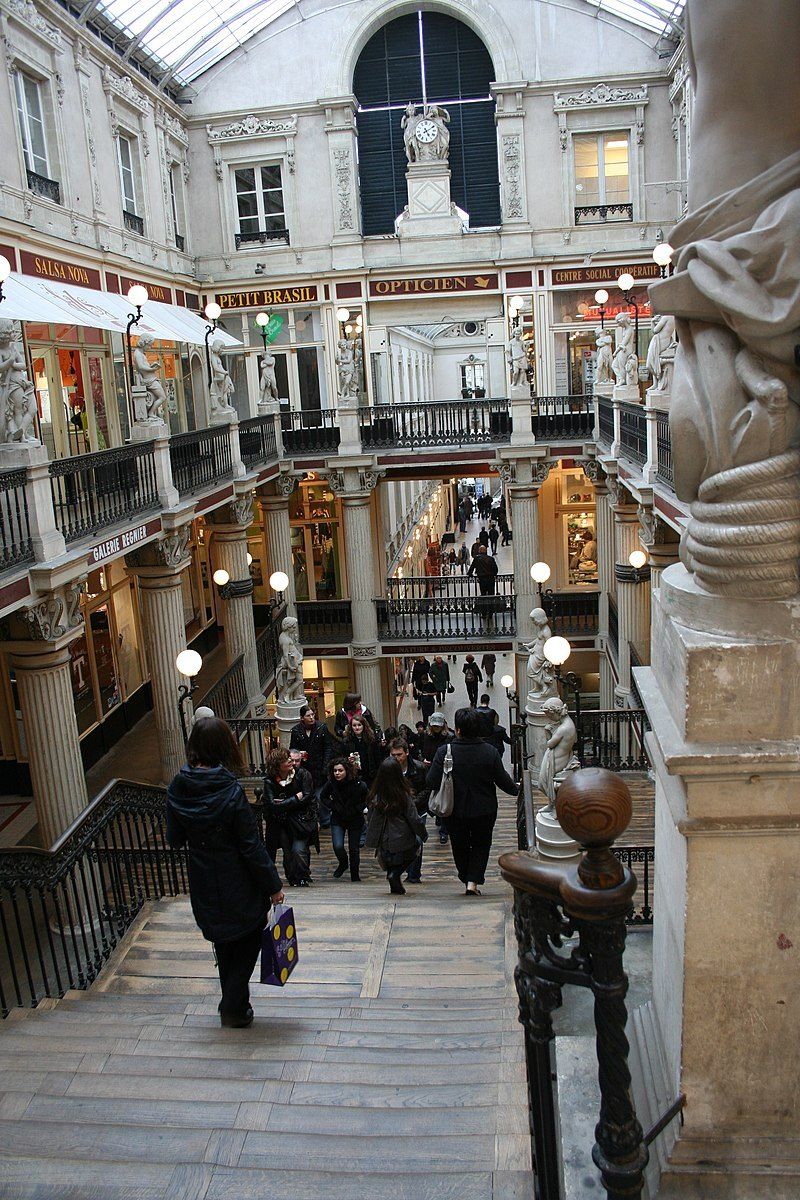
Nantes
## Description The Passage Pommeraye is one of the most striking covered passages in France, and a true architectural masterpiece from the 19th century. Built between 1840 and 1843, it is both a shopping arcade and a monument of historical significance. What sets it apart is its unique three-level structure, which cleverly adapts to the natural slope of the land between Rue de la Fosse and Rue Santeuil. This allows visitors to walk through the gallery while experiencing a gradual elevation, framed by ornate staircases, decorative sculptures, and elegant ironwork. The atmosphere inside is one of timeless sophistication. Light streams in through a glass roof, highlighting neoclassical statues and intricate details that make every corner worth admiring. The arcade houses a variety of boutiques, from luxury shops to independent stores, making it both a shopping destination and a cultural experience. A little-known fact about the Passage Pommeraye is that it was once considered a risky investment. Louis Pommeraye, a local lawyer turned developer, envisioned the arcade as a way to connect two streets of different heights. Many thought the project was too ambitious and doomed to fail. Yet today, it is one of Nantes’ most celebrated landmarks and a symbol of the city’s entrepreneurial spirit. Another fun detail is that the passage has been featured in several films, including Jacques Demy’s *Lola* (1961), cementing its place in French cinematic history. ## Location The Passage Pommeraye is located in **Nantes**, the capital of the **Loire-Atlantique** department in the **Pays de la Loire** region of western **France**. It sits in the heart of the city center, connecting **Rue de la Fosse** with **Rue Crébillon** and **Rue Santeuil**, making it an essential stop for anyone exploring Nantes. Getting there is easy. From the Nantes train station (Gare de Nantes), it’s about a 20-minute walk or a short ride on the city’s efficient tram network—Line 1 to the “Commerce” stop places you within minutes of the passage. Visitors coming from Paris can reach Nantes in just over two hours via high-speed TGV train, making the Passage Pommeraye a convenient and rewarding day-trip highlight. ## Tips * **Take your time:** While you can walk through the passage in minutes, slow down to admire the statues, balustrades, and architectural details. * **Visit on a weekday:** Weekends and holidays can be crowded, especially during sales seasons or Christmas. A weekday visit provides a calmer experience. * **Look up:** The glass roof and decorative sculptures are among the most remarkable elements—don’t miss them while focusing only on the shops. * **Combine with nearby attractions:** The passage is centrally located, close to Place Royale and the Graslin district, where you’ll find theaters, cafés, and other cultural landmarks. * **Enjoy seasonal magic:** During the Christmas period, the arcade is beautifully decorated, creating an enchanting festive atmosphere. * **Photography tip:** Arrive early in the morning to capture the arcade without too many people in the frame. ## Conclusion The Passage Pommeraye is not just a shopping arcade but a masterpiece of 19th-century urban design. With its harmonious blend of architecture, light, and history, it has become one of Nantes’ most treasured sites. Whether for shopping, sightseeing, or simply soaking up the atmosphere, it offers a memorable experience that combines elegance with everyday life. ## FAQ **1. What makes the Passage Pommeraye unique?** Its three-level design that adapts to a sloping street, combined with ornate sculptures and architectural details, makes it one of the most distinctive arcades in Europe. **2. Is the Passage Pommeraye free to enter?** Yes, entry is completely free, and visitors can walk through at any time during opening hours. **3. What kind of shops can be found inside?** The passage features a mix of luxury boutiques, independent shops, jewelry stores, fashion outlets, and cafés. **4. Can I visit the Passage Pommeraye at night?** The shops close in the evening, but the passage itself remains open for walking until later hours, allowing visitors to enjoy its illuminated beauty. **5. How long does a visit usually take?** A casual walk-through might take 15–20 minutes, but to explore shops and enjoy the atmosphere, allow at least an hour. **6. Is the Passage Pommeraye accessible for people with limited mobility?** Yes, elevators have been added in recent years to improve accessibility, although the original staircases remain a prominent feature. ## Links * [Passage Pommeraye](https://en.wikipedia.org/wiki/Passage_Pommeraye)
GemVoyage Team • World
Cordoba
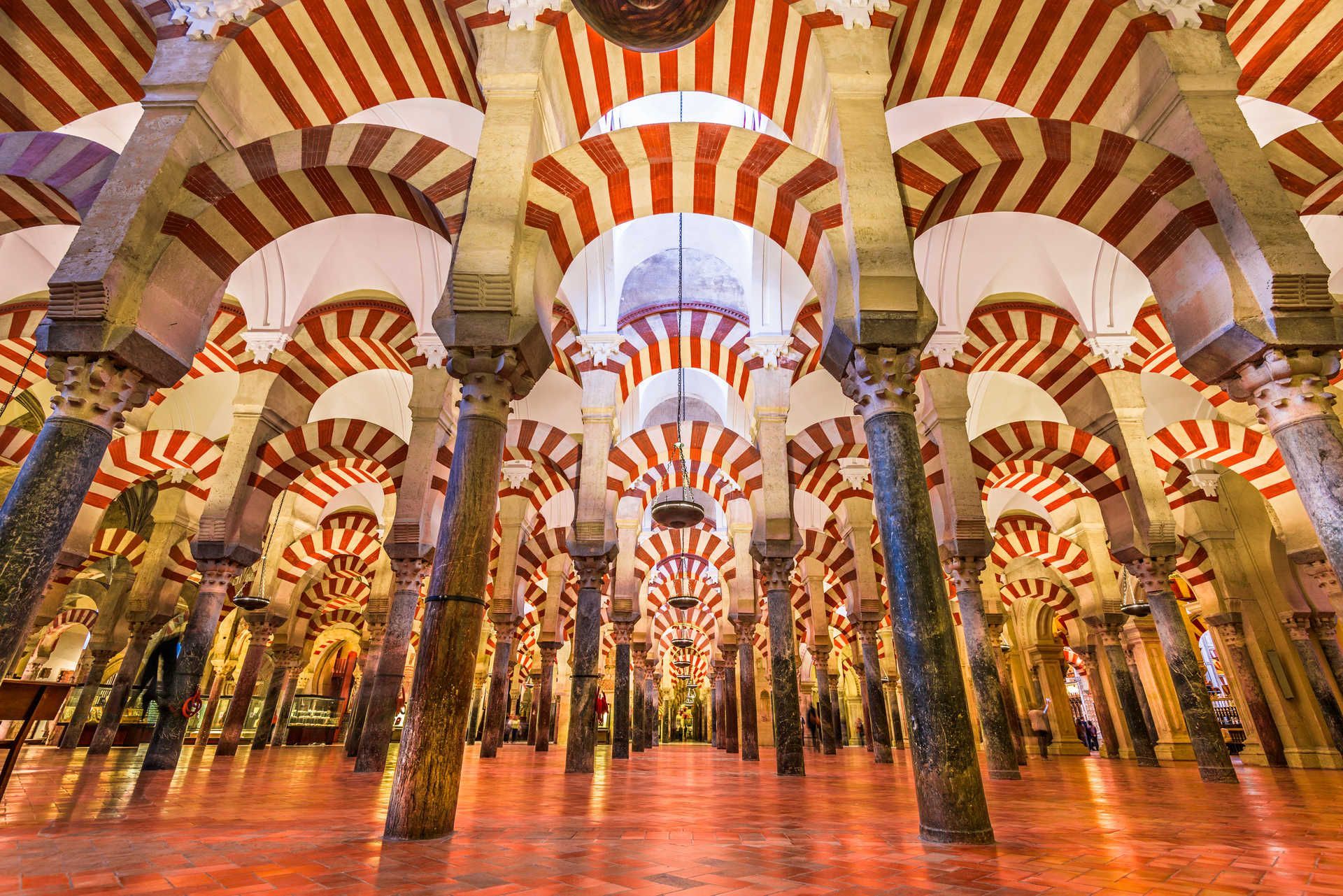
## Description The Mezquita de Córdoba (commonly referred to as the Mosque–Cathedral of Córdoba) is one of Spain’s most striking architectural masterpieces, blending Islamic and Christian elements into a single, atmospheric monument. Its forest of red-and-white double arches, an ingenious structural and aesthetic solution developed in the 8th and 9th centuries, creates a hypnotic interior rhythm that has captivated visitors for centuries. What makes the Mezquita distinctive is not only its scale and decorative richness, but also its layered history: first a Visigothic site, then a grand mosque during Al-Andalus, and later converted into a cathedral after the Reconquista. The result is an unusual palimpsest of art and faith, where horseshoe arches, ornate mihrab mosaics, and later Renaissance chapels coexist in one vast interior. Little-known facts: the current cathedral nave was inserted into the mosque in the 16th century after repeated political and religious negotiations, leaving a striking contrast between the Muslim prayer hall and a centrally placed Christian choir. Another subtle detail is that several columns were recycled from nearby Roman and Visigothic ruins, embedding older materials into this Islamic monument. ## Location The Mezquita is located in Córdoba, Andalusia, southern Spain. It sits in the historic core (the Judería), a compact medieval district adjacent to the Guadalquivir River. The precise address is Plaza del Campo Santo de los Mártires, 1, Córdoba, Andalusia, Spain. Getting there: Córdoba is on Spain’s high-speed rail network (AVE) with frequent trains from Madrid (about 1 hour 45 minutes) and Seville (about 45 minutes). From Córdoba’s main train station (Estación Córdoba Central), the Mezquita is a 15–20 minute walk through the old town; taxis and local buses are also available. If you’re driving, look for parking near Avenida del Alcázar; from there the old town is a short walk. Once inside the historic center, much is best experienced on foot. ## Tips - Buy tickets in advance: The Mezquita can get extremely crowded, especially during high season. Pre-booked tickets with a timed entry avoid long queues. - Visit at quieter times: Early morning just after opening or late afternoon before closing are the best times for photography and to avoid tour groups. - Dress respectfully: As an active cathedral, modest clothing is appreciated. - Allow time for the surrounding quarter: The Judería, Calleja de las Flores, and the Roman bridge are part of the full Córdoba experience—plan at least 2–3 hours to explore the mosque-cathedral and nearby streets. - Use an audio guide or a knowledgeable guide: There’s a lot of layered history; a guide helps unpack architectural changes, symbolic elements, and the timeline of conversions. - Combine with other sites: Pair the Mezquita with the Alcázar of the Christian Monarchs and the Medina Azahara archaeological site for a broader historical view. ## Conclusion The Mezquita de Córdoba is an unforgettable site where architecture tells a story of cultural exchange, conquest, and coexistence. Its forest of arches, rich mosaics, and the surprising placement of the cathedral nave inside a former grand mosque make it a must-visit for lovers of history, architecture, and complex heritage. A mindful visit, planned for quieter hours, will reveal subtleties many miss on a quick stop. ## FAQ Q: Is the Mezquita still used for religious services? A: Yes. While much of the building functions as a major cultural monument and tourist site, the cathedral section hosts Christian religious services. Q: How long should I plan to visit? A: Expect 1.5–3 hours to explore the main areas and enjoy nearby streets. Add more time if visiting exhibitions or local museums. Q: Are photography and flash allowed? A: Photography is usually allowed without flash; however, rules can change for certain ceremonies or exhibitions—follow posted signs. Q: Is the Mezquita accessible for visitors with reduced mobility? A: Parts of the site have limited accessibility due to historic flooring and narrow passages; check official accessibility information and consider contacting the site before arrival. ## Links - [Wikipedia: Mezquita–Cathedral of Córdoba](https://en.wikipedia.org/wiki/Mosque–Cathedral_of_C%C3%B3rdoba) - [Official tourism page for Córdoba (visit cordoba)](https://www.turismodecordoba.org)
GemVoyage Team • World
Gran Sabana
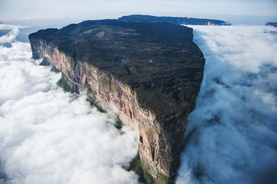
## Description Mount Roraima is a striking tabletop tepui — a flat-topped sandstone mesa — rising abruptly from the Gran Sabana plateau along the Venezuela–Brazil–Guyana border. Immensely atmospheric, its sheer cliffs and mist-shrouded summit inspired Arthur Conan Doyle’s The Lost World; the summit supports endemic plants and sculptural rock formations carved by erosion and persistent cloud. Trekking to Roraima’s summit is an otherworldly journey through shifting ecosystems: savanna, tepui foothills, cloud forests and alien rocky plateaus dotted with carnivorous plants and primitive flora. What makes Roraima singular is its biology and geology: tepuis act as ecological islands where species evolved in isolation, resulting in endemic flora and fauna found nowhere else. The plateau’s quartzite sandstone and erosional patterns carve shallow sinkholes and intricate channels that collect rainwater, forming microhabitats. Visitors encounter oddly-shaped boulders, deep natural cisterns and ephemeral pools that support plant communities adapted to thin soils and high rainfall. Beyond science, the experience is sensory: mist and cloud sweep across the summit, light transforms the slick rock faces, and nights on the plateau can be cold and silvery. For many, the trek to Roraima — along river crossings, open savanna and jungle gullies — delivers a sense of expeditionary travel; the route requires multi-day camping and careful logistical planning. ## Location Mount Roraima sits in the Gran Sabana region of southeastern Venezuela (Canaima National Park), at the tri-border with Guyana and Brazil. Most treks begin from the Venezuelan side, with popular access points around Paraitepuy or via Canaima; flights to Canaima followed by drives and river transfers are common. Organizing a Roraima expedition requires permits, an experienced guide and coordination for river logistics and camping equipment. Given its border location, some itineraries approach Roraima from Guyana — these routes are less common for international visitors but viable for those with appropriate travel documents and local arrangements. Venezuelan-side treks are the classic choice and usually include boat transfers, vehicle rides across savanna, and multiple days of trekking culminating with the scramble onto the plateau. ## Tips - **Book with experienced operators:** Choose accredited guides or operators who handle permits, river logistics, and camping gear. The plateau’s remoteness demands reliable local knowledge and safety planning. - **Fitness and acclimatization:** The trek is physically demanding, often involving long days of walking across uneven terrain, river crossings and carrying a daypack while guides transport communal gear. Conditioning with endurance hikes and strength training helps. - **Pack for extremes:** Expect heavy rain, intense sun at low elevations, muddy jungle stretches and cool winds on the summit. Waterproof layers, quick-dry clothing, high-traction trekking boots, gaiters, and a warm down layer for nights on the plateau are essential. - **Protect electronics and paper maps:** Use dry bags for sleeping gear and phone/ camera protection; quick access to waterproof maps or offline GPS tracking improves navigation in jungle and savanna. - **Leave no trace:** Camp on durable surfaces, pack out all waste, and avoid disturbing endemic plants on the plateau. The tepui ecosystem is delicate and regenerates slowly. - **Plan for altitude and weather:** The plateau can be cold and windy; thermal layers for nighttime and sun protection for daytime are both necessary. Bring a reliable headlamp and spare batteries for early starts or late arrivals. - **Permits and border considerations:** Verify permit requirements, carry appropriate identification, and confirm whether your route crosses national borders — passports and travel documents must be in order. ## Conclusion Mount Roraima offers a genuine expedition into a primeval landscape where geology and isolated evolution create surreal scenery. For adventurous travelers, the tepui’s summit is both a physical challenge and a revelation in biodiversity. The trek is unforgettable for those who embrace its remoteness — mist-wrapped cliffs, otherworldly rock formations, and night skies uncluttered by light pollution create one of South America’s most singular natural experiences. ## FAQ - **Q: How long is the trek to Roraima’s summit?** A: Typical treks last 6–8 days round-trip, depending on route and pace. Some itineraries are longer if they include extra side excursions in the Gran Sabana or additional borderside logistics. - **Q: Is the trek technical or suitable for beginners?** A: The trek is non-technical in terms of climbing gear but is physically demanding and involves uneven, slippery surfaces and river crossings. Experienced guides can support less-experienced hikers, but a baseline of good fitness is important. - **Q: What permits or documents are required?** A: Permits vary by entry point and country. When approaching from Venezuela, arrange permits via a licensed operator; if approaching from Guyana or Brazil, confirm local regulations. Always carry valid ID and passport when near border areas. - **Q: When is the best time to trek Roraima?** A: The drier months (roughly December to April) are generally more manageable, but weather on tepuis can be unpredictable year-round. Avoid peak rainy periods when trails become more treacherous. - **Q: What wildlife and plant life should I expect?** A: Expect specialized endemic plants, carnivorous species like pitcher plants in microhabitats, and unique lichens and mosses on the summit. Larger wildlife is mostly absent on the plateau, but wildlife sightings are possible in the lowland savanna and rainforest approaches. - **Q: Is camping on the plateau comfortable?** A: Camping is rustic: bring a four-season or high-quality three-season tent and warm sleeping gear. Nighttime temperatures can drop sharply and winds can be strong. ## Links - [Mount Roraima — Wikipedia](https://en.wikipedia.org/wiki/Mount_Roraima)
GemVoyage Team • World

Comments