GemVoyage Team • World
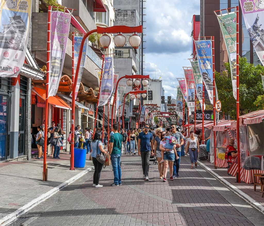
What makes Liberdade especially worth visiting is that it offers a concentrated version of São Paulo’s diversity. You can spend a morning browsing specialty stores, have lunch in a small noodle house, visit a cultural institution in the afternoon, and then return after dark when the lanterns and signage give the area a different atmosphere. One little-known fact is that Liberdade was not always associated with Japanese culture; its history includes Afro-Brazilian heritage, older residential uses, and a long process of demographic change that turned it into the cultural hub it is today. Another interesting detail is that the neighborhood’s famous portal and decorative elements are relatively recent compared with the area’s older urban fabric, so the visual identity you see now is the result of deliberate community expression, not simply architectural tradition.
The district is also a practical place for travelers who like food and street photography. The weekend market and surrounding streets often create a lively scene, but even on quieter weekdays Liberdade rewards slow wandering. The area’s small shops often carry imported snacks, tea, ceramics, stationery, and gifts that are hard to find elsewhere in the city. That mix of everyday utility and cultural symbolism is what gives Liberdade its appeal. It feels authentic because it functions as a neighborhood first and a visitor destination second.
The easiest way to get there is by metro, especially if you are staying in another part of São Paulo. Taxis and ride-hailing services also work well, but public transport is usually faster because traffic can be heavy. If you are already exploring central São Paulo on foot, Liberdade can be reached through a longer but manageable walk from nearby districts. For first-time visitors, arriving by metro is the most straightforward option because it drops you right into the neighborhood’s main pedestrian flow.
Bring cash and a flexible appetite, because many of the best snacks, pastries, and small purchases are easiest to enjoy from informal stalls and compact shops.
Don’t limit yourself to the main street. Some of the most interesting details are in the side streets, where older buildings, small restaurants, and local businesses reveal the neighborhood’s everyday rhythm.
If you like photography, go at different times of day. Morning light, afternoon bustle, and evening lanterns all give Liberdade a different visual character.
Combine the visit with nearby central landmarks so the trip feels like part of a broader São Paulo itinerary rather than a standalone stop.
Discover more hidden gems you might love.
Lille
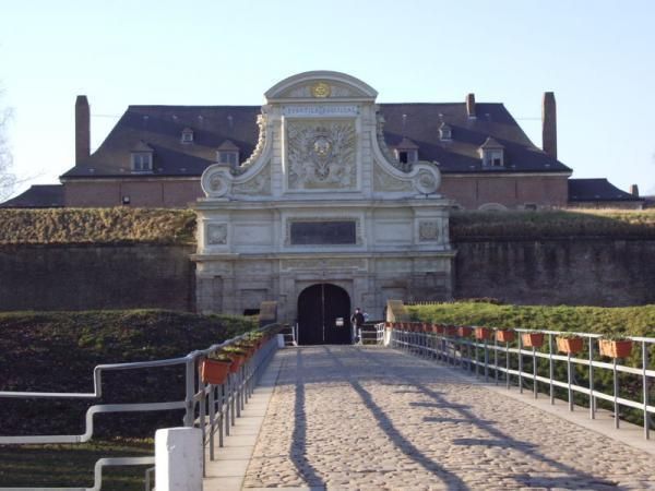
## Description The Citadel of Lille is one of the most impressive military structures in France and a major reason the city is often mentioned in discussions of European fortress design. Built in the 17th century under the direction of Vauban, the citadel is a star-shaped defensive complex that demonstrates both engineering precision and political ambition. It was intended to protect Lille after the city came under French control, and today it stands as a reminder of how military architecture could also shape a city's identity and landscape. What makes the citadel special is that it is not only technically significant but also visually elegant. Its geometric form, wide moats, robust bastions, and open green surroundings make it feel like a fortress designed by someone who understood both defense and urban order. Even if you are not deeply interested in military history, the citadel is compelling because of how it connects architecture, public space, and the natural environment. It is both a monument and a park-like setting, which gives it a very different feeling from densely built old-town landmarks. One little-known fact is that the Citadel of Lille is sometimes referred to as the "queen of citadels" because of its importance in Vauban's defensive system. Another detail many visitors miss is how well the structure fits into the modern city. Although originally conceived for warfare, the citadel now helps define a recreational and cultural zone where walking, cycling, family outings, and visits to nearby attractions all take place. That transformation from military stronghold to civic landmark is part of what makes the site interesting today. The citadel also helps visitors understand Lille's broader history. The city sat near contested borders for centuries, so fortifications were more than symbolic; they were necessary tools of survival and control. Standing at the citadel, you can sense the strategic value of the location and see how a military engineer like Vauban thought about terrain, sightlines, and access. For architecture lovers, history enthusiasts, and casual walkers alike, it is one of Lille's most rewarding destinations. ## Location The Citadel of Lille is in Lille, in the Hauts-de-France region of France, west of the historic center near the Deûle River and surrounding parkland. Its location makes it easy to combine with a broader exploration of Lille's old quarters, especially if you are already spending time around the city center. Unlike a fortress in a remote military zone, this citadel sits comfortably within the urban fabric while still feeling spacious. Getting there is simple by foot, bicycle, or local transport. If you are staying in central Lille, a walk to the citadel is pleasant and reveals how the city's layout changes as you move from dense streets to more open green space. Buses and taxis can also bring you close, but many visitors prefer to use the approach as part of a longer stroll. Because the citadel is surrounded by parks and walking routes, it works especially well as part of a relaxed day outdoors. You can combine it with the nearby zoo, river paths, or other west-side attractions if you want to make the most of the area. ## Tips Allow time for the surroundings as well as the fortress itself. The citadel's setting in parkland is one of its greatest strengths, and the experience improves when you treat it as part of a broader walk rather than a quick photo stop. If you are interested in military history, read a little about Vauban before visiting. His work shaped many French fortifications, and understanding his methods makes the citadel much more meaningful. Visit in good weather if you want to enjoy the outdoor environment fully. The site is enjoyable year-round, but clear conditions make the geometry and scale easier to appreciate. Bring comfortable shoes or use a bicycle if you plan to cover more of the surrounding area. The citadel fits naturally into an active day in Lille and is especially pleasant for travelers who enjoy a mix of history and open-air walking. ## Conclusion The Citadel of Lille is a landmark of French military architecture and a beautiful place to understand the strategic history of the city while enjoying one of its most open and pleasant landscapes. ## FAQ ### Who built the Citadel of Lille? It was designed by Vauban, the famous French military engineer, in the 17th century. ### Why is the citadel important? It is important because it is one of the best examples of Vauban's fortification work and a key part of Lille's historical defense. ### Can you visit the citadel today? Yes. The area is accessible and widely used for walking and recreation, though access may vary in specific sections. ### Is it close to Lille's city center? Yes. It is located west of the center and is easy to reach on foot or by local transport. ## Links - [Lille tourism](https://www.lilletourism.com/) - [Wikipedia article](https://en.wikipedia.org/wiki/Citadel_of_Lille)
GemVoyage Team • World
Kyoto
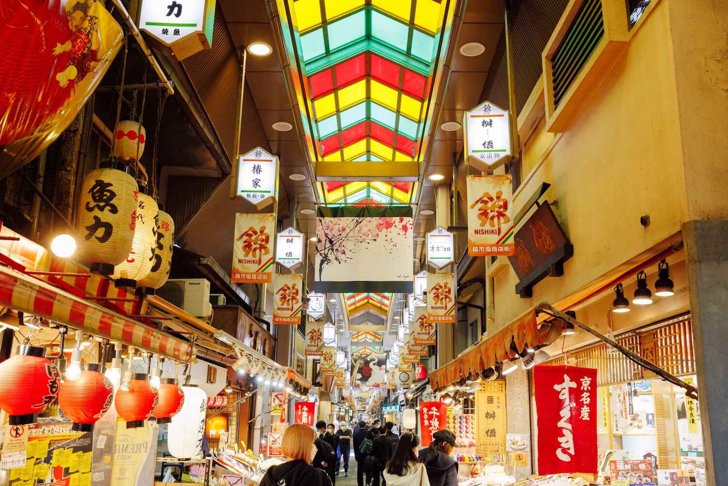
## Description Nishiki Market, often called **“Kyoto’s Kitchen”**, is one of the most famous traditional markets in Japan. Stretching about 400 meters through the heart of Kyoto, this lively covered arcade is lined with more than 120 shops and stalls, each offering a unique slice of local culture. From fresh seafood and seasonal produce to traditional sweets, pickles, and kitchenware, Nishiki Market provides an authentic experience of Kyoto’s culinary heritage. What makes Nishiki Market truly unique is its focus on local and specialty products. Many of the vendors have been running family businesses for generations, preserving recipes and traditions that date back hundreds of years. As you wander through, you’ll notice the atmosphere is both bustling and intimate—a blend of locals doing their shopping and tourists sampling delicacies for the first time. A little-known fact is that Nishiki Market dates back to the early **14th century**, making it more than 700 years old. It originally started as a wholesale fish market before expanding into a diverse food street. Another interesting detail is that some stalls offer free samples, encouraging visitors to try everything from roasted chestnuts to unusual treats like octopus stuffed with quail eggs. ## Location Nishiki Market is located in **Kyoto**, within the **Kansai region** of **Japan**. More precisely, it lies in the **downtown Nakagyo Ward**, running parallel to Shijo Street and between Teramachi and Takakura streets. Its central location makes it easy to access and an ideal stop while exploring other nearby attractions such as Gion, Pontocho Alley, and Nishiki Tenmangu Shrine. How to get there: * **By subway:** Take the Karasuma Line to **Shijo Station** or the Tozai Line to **Karasuma Oike Station**, then walk about 5–10 minutes. * **By bus:** Several Kyoto City buses stop near Shijo Street, providing easy access from other parts of the city. * **By taxi:** A taxi is convenient if you’re traveling with luggage or staying outside the downtown area. Because of its central location, Nishiki Market can easily be combined with a day of shopping in Shijo-Kawaramachi or sightseeing in Gion. ## Tips To fully enjoy Nishiki Market, here are some practical tips for visitors: 1. **Go early or late** – The market can get crowded around midday, so visiting in the morning or late afternoon offers a more relaxed experience. 2. **Try local specialties** – Don’t miss Kyoto delicacies like yuba (tofu skin), tsukemono (pickles), fresh mochi, and matcha-flavored treats. 3. **Bring cash** – While larger shops may accept cards, many stalls are cash-only. 4. **Respect the “no eating while walking” rule** – Many stalls ask customers to eat food in designated areas instead of while walking through the market. 5. **Plan for at least an hour** – With so many shops and food stalls to explore, allow enough time to browse and taste at leisure. 6. **Combine with nearby attractions** – After exploring the market, visit Nishiki Tenmangu Shrine, which sits at the eastern end of the street. ## Conclusion Nishiki Market is more than just a shopping street—it’s a living museum of Kyoto’s culinary traditions. With its centuries-old history, diverse food offerings, and lively atmosphere, the market provides visitors with an unforgettable journey into the flavors and culture of Japan’s ancient capital. Whether you’re sampling street food, buying souvenirs, or soaking in the ambiance, Nishiki Market is a must-visit destination in Kyoto. ## FAQ **1. What is Nishiki Market famous for?** Nishiki Market is known as “Kyoto’s Kitchen,” offering traditional foods, local specialties, and cultural goods that represent the essence of Kyoto’s culinary heritage. **2. What are the opening hours of Nishiki Market?** Most shops open around 9:00 AM and close by 6:00 PM, though hours vary by vendor. It’s best to visit during the daytime. **3. Is Nishiki Market free to enter?** Yes, entry is free. You only pay for the food or items you buy. **4. How long does it take to walk through Nishiki Market?** The market itself can be walked in 20–30 minutes, but most visitors spend 1–2 hours browsing, eating, and shopping. **5. Is Nishiki Market suitable for vegetarians?** Yes, while many stalls sell seafood and meat, there are plenty of vegetarian options like tofu, yuba, pickles, and sweets. **6. Can I buy souvenirs at Nishiki Market?** Absolutely. In addition to food, the market has shops selling kitchenware, chopsticks, ceramics, and traditional Kyoto crafts. ## Links * [Kyoto Official Travel Guide](https://kyoto.travel) * [Japan National Tourism Organization](https://www.japan.travel)
GemVoyage Team • World
Milan
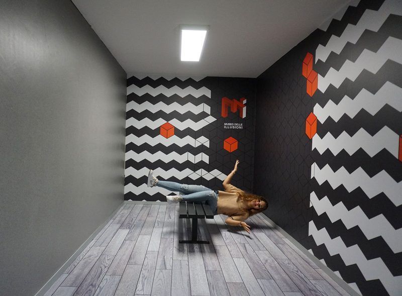
## Description The **Museo delle Illusioni – MDI** in Milan is a contemporary museum designed to challenge the viewer’s understanding of **vision, perception, spatial logic, and cognitive bias**. Unlike traditional museums that focus on historical artifacts or fine arts, MDI operates at the intersection of **science, psychology, and interactive entertainment**, offering an environment where visitors actively participate in the experience rather than observe passively. The space is filled with **optical illusions, perspective rooms, rotating installations, holograms, paradox structures, and sensory challenges** that push visitors to reconsider how the brain interprets visual information. Every room is intentionally constructed to distort scale, depth, orientation, and movement. The museum’s core idea is simple but effective: **what you see is not always what exists**, and the brain can be easily misled when context changes. What differentiates Milan’s MDI from similar illusion museums elsewhere is its emphasis on **sleek design and technical precision**. Installations are engineered with high production quality and clean aesthetics consistent with Milan’s reputation as a design capital. The lighting, angles, and surfaces are calibrated to deliver strong photographic effects, making the museum particularly popular among visitors who enjoy **creative photography and social media content**. Many exhibits demonstrate foundational principles of **Gestalt psychology, neuroscience, and geometry**, though without overwhelming visitors with complex scientific language. The goal is to make scientific concepts **intuitive, experiential, and playful**. By physically stepping into illusions, visitors experience cognitive phenomena that are normally confined to textbooks or laboratory experiments. A little-known fact is that several rooms in the museum use **forced perspective techniques** originally borrowed from early film production and Renaissance stage design. Another interesting detail is that some of the illusions at MDI come from a global research network of visual-perception experts who continually update the installations based on emerging cognitive science findings. Emotionally, the museum operates on a gradient between surprise and curiosity. Children laugh at rooms where gravity seems reversed, adults puzzle over patterns that appear to move, and groups experiment with depth tricks to produce impossible photographs. The museum’s strength lies in its ability to make **intellectual play accessible**, bridging the gap between learning and entertainment. MDI is not a large museum, and it does not intend to be. Its impact comes from **concentration, novelty, and careful choreography**. A visit typically moves quickly, but the density of experiences ensures that visitors remain mentally engaged throughout. In a city known for design excellence, the Museo delle Illusioni offers a refreshing and contemporary counterpoint: an environment where **visual culture becomes an interactive game**, and where perception becomes the main exhibit. ## Location The **Museo delle Illusioni – MDI** is located in the central area of Milan, close to major attractions and easily accessible on foot or by public transport. **City:** Milan **Region:** Lombardy (Lombardia) **Country:** Italy **Address Area:** Near **Porta Venezia** and the **Corso Buenos Aires** district ### How to Get There: * **By metro:** * **M1 (Red Line)** to **Porta Venezia**; the museum is a short 5–7 minute walk. * **By tram:** Various tram lines stop along Corso Venezia and Via Palestro. * **By bus:** Several city buses serve the area around Porta Venezia. * **By car:** Parking is limited and often busy; public transport is strongly recommended. * **On foot:** The museum is easily combined with strolls through **Giardini Indro Montanelli** and nearby galleries. Its central location makes it convenient to pair with shopping, dining, or museum visits in the same outing. ## Tips * **Pre-book tickets:** The museum is popular and time slots fill quickly, especially on weekends. * **Bring a fully charged phone or camera:** Many installations are designed for interactive photography. * **Visit during off-peak hours:** Early afternoons on weekdays offer the best conditions for photos without crowds. * **Expect a short but dense visit:** Most people spend **45–75 minutes** inside. * **Some illusions require participation:** Be ready to pose, experiment, and move around. * **Families will find the space especially engaging:** The illusions work well for children and adults alike. * **Check for rotating exhibits:** Some temporary installations appear seasonally. ## Conclusion The **Museo delle Illusioni – MDI in Milan** delivers an intelligent, playful, and visually rich exploration of how the mind constructs reality. With its polished installations, scientific underpinnings, and strong interactive component, it stands out as one of the city’s most modern cultural experiences. It offers not only entertainment, but also a clear reminder that **perception is fundamentally subjective**. ## FAQ **1. How long does a typical visit take?** Most visitors spend **about one hour** exploring the installations. **2. Is the museum suitable for children?** Yes. It is highly **family-friendly**, with exhibits designed for all ages. **3. Do I need to book in advance?** Yes. **Online reservation** is recommended to secure preferred time slots. **4. Can I take photos inside?** Absolutely. Photography is encouraged, and many rooms are designed for it. **5. Is the museum accessible?** Most areas are accessible for visitors with reduced mobility, though some illusions may be difficult to experience physically. **6. Is it crowded?** It depends on the time and day. **Weekends and holidays** are the busiest. ## Links * [Museo delle Illusioni – Milan Official Website](https://moimilano.it/en/)
GemVoyage Team • World
Mexico City
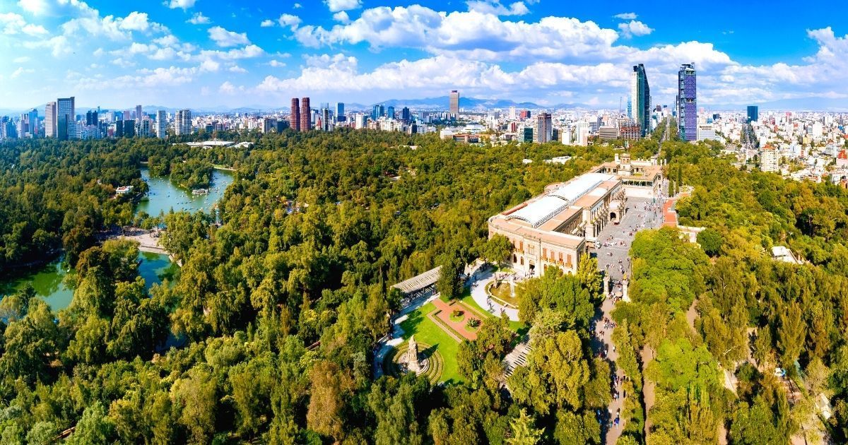
## Description Chapultepec Forest (Bosque de Chapultepec) is one of the largest and most consequential urban parks in the Americas, a living green lung at the heart of Mexico City that blends natural landscapes with civic life, culture, and history. More than a municipal park, Chapultepec is a multilayered cultural landscape: wide oak and pine groves, winding paths, boating lakes, formal gardens, archaeological sites, and a string of world-class museums make it a singular destination for both visitors and residents. Its scale and diversity mean you can shift within minutes from a quiet shaded trail to a museum day or a lakeside picnic, and that versatility is precisely what makes Chapultepec so valuable. Chapultepec's importance is historical as well as recreational. The hill that holds Chapultepec Castle was once an Aztec refuge and later a site of colonial and early republican power. The Castillo de Chapultepec offers sweeping views across the city and houses collections that relate to Mexico’s political story. Meanwhile, the National Museum of Anthropology and other cultural institutions in the park hold artifacts and exhibitions of global significance. The juxtaposition of high-culture museums and everyday park life—runners, families, vendors, and informal musicians—gives Chapultepec a dynamic sense of place that resists being reduced to a single label. From a traveler’s perspective, Chapultepec is best approached as a set of distinct neighborhoods. The first section concentrates major museums and tourist attractions; the second section contains quiet lawns and intimate groves used more by locals; the third section opens into larger, less manicured green areas with a calmer atmosphere. Each offers different rhythms: concentrated cultural learning, relaxed recreation, or more wilderness-like wandering. ## Location Chapultepec sits in central Mexico City, stretching west from Paseo de la Reforma into the adjacent neighborhoods of Polanco and Lomas de Chapultepec. It’s highly accessible: multiple metro stops and bus lines border the park and taxis or rideshares drop you close to major entrances. Because it’s integrated into the city rather than fenced off, think of Chapultepec as an urban zone with many points of entry rather than a single gated park. If your priorities are museums, start at the first section near the National Museum of Anthropology and the Museum of Modern Art. For boating and family activities, head to the lake area. For a quieter, more local experience, explore the second and third sections where joggers and picnickers are the dominant users. Allow travel time between sections if you plan to combine multiple activities. ## Tips - Prioritize: choose one or two zones (museums, lake and boats, or quiet groves) to avoid overambitious itineraries. - Start early: museums open mid-morning, and earlier starts beat crowds and heat. - Use public transit: nearby metro stations and eco-bus lines reduce parking hassles. - Wear layers and comfortable shoes: shaded groves can be cool while open plazas warm up quickly. - Pair the visit with neighborhood dining in Polanco or a stroll down Reforma for monuments and architecture. - Bring water, sunscreen, and small change for boat rentals and food stalls. ## Conclusion Chapultepec Forest is an essential part of a Mexico City visit because it combines culture, outdoor recreation, and historical depth in one central, walkable area. It’s best enjoyed with a focused plan—pick the experience that appeals most and accept that the park rewards repeat visits as much as one long day. ## FAQ ### Why is Chapultepec Forest so important? It combines large-scale green space, national museums, historical monuments, and everyday civic life in a single urban zone, making it central to Mexico City’s identity and visitor itineraries. ### Can I visit it in one afternoon? You can visit a focused part of Chapultepec in an afternoon—for example, Castillo de Chapultepec plus one museum—but seeing the whole park requires multiple visits. ### Is it family-friendly? Absolutely. The park has playgrounds, boat rentals, family-friendly museum exhibits, and wide lawns suitable for picnics and group activities. ### Are there museums inside the forest? Yes. Highlights include the National Museum of Anthropology, the Museum of Modern Art, Museo Tamayo, and Chapultepec Castle’s historic collections. ### What is the best way to explore it? Map one or two zones in advance, use public transit to arrive near those entrances, mix indoor and outdoor stops, and allow time to rest between high-intensity museum visits. ## Links - [Official website](https://www.chapultepec.org.mx/) - [Wikipedia](https://en.wikipedia.org/wiki/Chapultepec)
GemVoyage Team • World
Venice
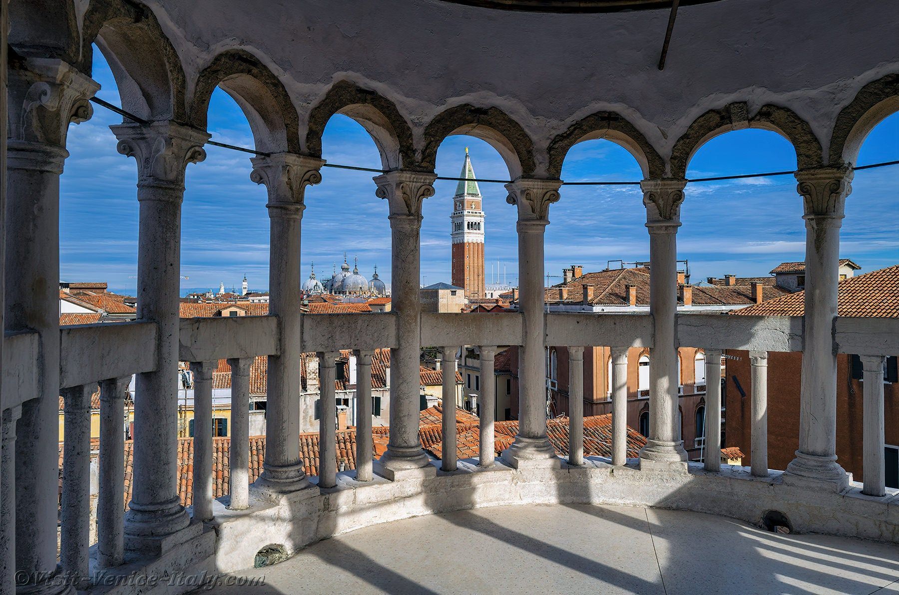
## Description Scala Contarini del Bovolo is one of those Venice attractions that feels almost secret, even though it has become increasingly known among travelers who enjoy architecture and quieter city experiences. Its fame comes from the extraordinary spiral staircase wrapped around the exterior of the building, rising like a stone shell above the narrow streets of the city. The staircase is the defining image, but the true appeal is the way it combines elegance, surprise, and Venetian craftsmanship in one compact site. The word “bovolo” refers to a snail shell in Venetian dialect, and that name makes perfect sense once you stand in front of the structure. The staircase coils upward in a graceful helix, creating one of the most photogenic details in all of Venice. Unlike the grand tourist corridors around St. Mark’s Square and the Rialto Bridge, this attraction feels tucked away and intimate. That sense of discovery is part of what makes it special. You are not just seeing another palace exterior; you are encountering a design that rewards curiosity and close attention. Another reason the Scala Contarini del Bovolo matters is that it represents a different side of Venice. Many visitors come for canals and churches, but this site shows how the city’s private palaces could also be architectural statements. The stair tower itself is a visual bridge between medieval urban density and Renaissance taste for ornament and order. A lesser-known fact is that the staircase became famous not only because it is beautiful, but because it is unusual in a city where vertical, exterior stair structures are relatively rare compared with the canals and façades that usually dominate the skyline. The experience is best when you take your time. From outside, the staircase already looks distinctive, but going inside and climbing it gives you a more complete sense of the building’s scale and perspective. As you ascend, the geometry changes and the city reveals itself through narrow openings, which creates a memorable transition from enclosed courtyard space to elevated views. It is a small attraction, but one that lingers in memory because it feels like a compact lesson in Venetian design. ## Location Scala Contarini del Bovolo is in Venice, Italy, in the historic center not far from the San Marco area and within walking distance of key inner-city landmarks. Its position in the dense urban fabric of Venice means it is easy to overlook unless you are specifically looking for it, which is part of the charm. The simplest way to reach it is on foot from the San Marco or Rialto area. Venice’s pedestrian layout makes walking the natural choice, and the staircase is best approached as part of a wandering route through the city rather than as a stand-alone destination by vehicle. If you are arriving by vaporetto, get off at a nearby stop such as Rialto or San Marco and continue on foot using a map, because the final approach takes you through small streets and passages that are easier to navigate slowly. Because Venice can be crowded, it is worth planning this visit during a quieter part of the day. Early morning or later afternoon can make the approach more pleasant and give you better photos without too many people around the staircase itself. ## Tips Bring a charged phone or camera, because the staircase is one of those details that rewards multiple angles. A shot from below captures the full spiral, while higher viewpoints show the contrast between the tower and the surrounding rooftops. Wear comfortable shoes. The site is small, but the walk through Venice often adds up to more steps than expected. The surrounding streets are also easier to enjoy when you are not rushed. Allow the visit to be part of a larger walking day rather than an isolated stop. It pairs well with nearby palaces, squares, and canal crossings, and that combination makes the city feel more layered. If you are interested in architecture, this is one of the most worthwhile short visits in Venice because it delivers a strong visual identity without requiring a major time commitment. ## Conclusion Scala Contarini del Bovolo is a compact but unforgettable Venetian landmark, known for its elegant spiral staircase and hidden location. It is a perfect stop for travelers who enjoy distinctive architecture and the quieter side of Venice. ## FAQ **Why is the Scala Contarini del Bovolo famous?** It is best known for its exterior spiral staircase, one of the most unusual and photogenic architectural details in Venice. **How long does a visit take?** Usually not long. Many visitors spend around thirty to sixty minutes, depending on how much time they spend taking photos and enjoying the views. **Is it easy to find?** It can be a little tricky because it is tucked into Venice’s narrow streets, so navigation by map is useful. **Is it good for photography?** Yes. The staircase itself and the elevated views from the structure both make it a strong photo stop. **Should I book in advance?** It is wise to check current opening arrangements before visiting, especially during busy travel periods. ## Links - [Wikipedia](https://en.wikipedia.org/wiki/Scala_Contarini_del_Bovolo)
GemVoyage Team • World

Victoria
## Description The Great Ocean Road is one of the world’s most celebrated coastal drives, winding along Victoria’s southwestern shoreline past rugged cliffs, surf beaches and sculpted limestone stacks such as the Twelve Apostles. Built by returned WWI soldiers and dedicated as a war memorial, the road combines engineering, natural wonders and seaside towns with cafes, galleries and surf culture. Dramatic viewpoints, rainforest gorges (like Great Otway National Park) and wildlife sightings (koalas, kangaroos and seabirds) make the route a versatile exploration corridor. What distinguishes the route is its dramatic juxtaposition of surf, limestone geology and accessible townscapes. Photographers and road trippers prize the series of staged viewpoints where walking tracks descend to coves and panoramic platforms look out to offshore stacks. Beyond the famous stacks, the route offers fern gullies and waterfalls in the Otways, coastal walks to hidden beaches, and small towns where food and surf culture combine. Many travelers craft multi-day itineraries that combine coastal hikes, wildlife spotting and culinary stops, from coffee in Torquay to seafood in Apollo Bay and heritage-listed lookouts around Port Campbell. The road’s memorial origins also allow visitors to reflect on the engineering feat and the region’s social history while enjoying one of Australia’s most scenic drives. ## Location The Great Ocean Road runs from Torquay to Allansford near Warrnambool in Victoria, Australia, with key stops including Anglesea, Lorne, Apollo Bay and the Twelve Apostles viewpoint at Port Campbell. Melbourne is the primary gateway, roughly a 1.5–3 hour drive to the start depending on traffic. ## Tips - **Avoid peak holiday traffic and plan overnight stops:** The route is popular during Australian school holidays; split the drive into staged stops to avoid fatigue and to enjoy hikes. - **Plan time for short walks and lookout detours:** Many of the best views require small detours and short walks; factor these into your itinerary rather than only driving. - **Mind driving conditions and seasonal weather:** Wind, sea spray and rain can change conditions quickly — watch for strong crosswinds and take care on narrow coastal roads. - **Book accommodation and tours in advance during peak season:** Lorne, Apollo Bay and Port Campbell fill quickly in summer — reserve ahead if travel dates are fixed. - **Pack layers and photography gear:** Coastal light changes quickly; bring windproof layers, a tripod for sunrise/sunset shots and protective gear for salt spray. ## Conclusion The Great Ocean Road pairs dramatic coastal geology with accessible townscapes and outdoor experiences, making it an essential Australian road trip for nature lovers and photographers. Thoughtful pacing and an eye for sidetracks reveal quieter coves, rainforest secrets and local food scenes that complement the iconic seascapes. ## FAQ - **Q: How long does the full drive along the Great Ocean Road take?** A: The direct driving time without stops is around 6–7 hours, but most travelers allocate 2–3 days to properly enjoy walks, viewpoints and coastal towns. - **Q: Can I drive the Great Ocean Road in a single day from Melbourne?** A: You can, but it will be rushed; an overnight stop (or two) allows for sunrise/sunset photography, hikes, and a relaxed pace. - **Q: Are there guided tours, or is it best to self-drive?** A: Both options are common: guided day tours suit short itineraries from Melbourne, while self-driving gives freedom to explore side tracks and lesser-known beaches. - **Q: What wildlife can I expect to see?** A: Look for koalas in eucalyptus stands, kangaroos in paddocks near dusk, seabirds along the cliffs and occasional whales on migration seasons from coastal lookouts. - **Q: Is the route safe for cyclists and motorcyclists?** A: Many cyclists and motorcyclists enjoy sections of the route, but be prepared for narrow lanes, tourist traffic, and windy coastal conditions; follow local safety advice. ## Links - [Great Ocean Road — Wikipedia](https://en.wikipedia.org/wiki/Great_Ocean_Road)
GemVoyage Team • World

Comments