GemVoyage Team • World
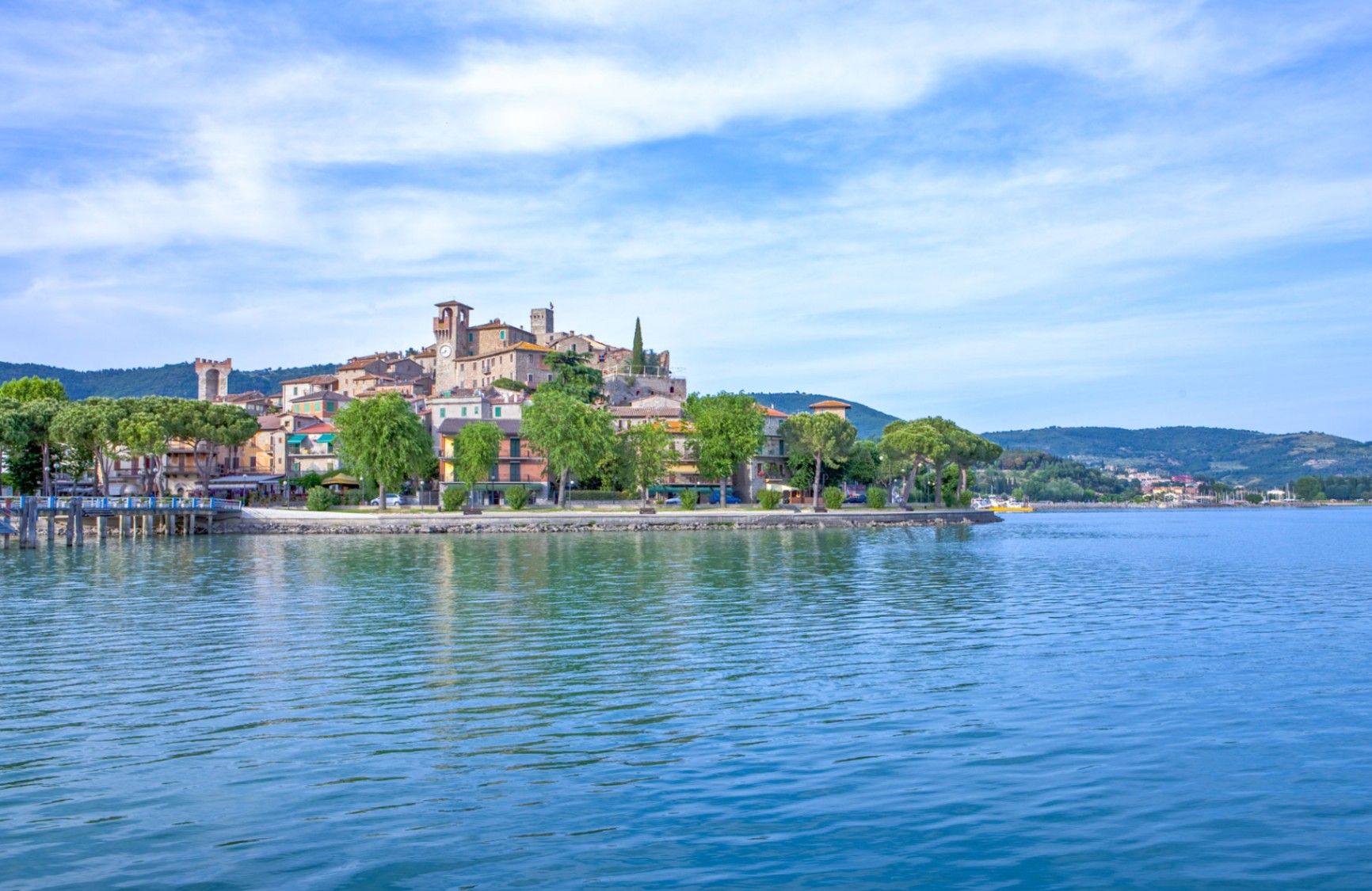
Lago Trasimeno is one of Italy’s largest lakes and among its most understated. Unlike the dramatic alpine lakes of the north, Lago Trasimeno is defined by breadth rather than depth, calm waters, and a landscape shaped by agriculture, small towns, and slow rhythms. It is a place where nature, history, and everyday Umbrian life coexist without spectacle.
The lake is shallow—its average depth is only a few meters—which gives it a distinctive character. Water levels fluctuate noticeably with the seasons, creating wetlands that attract migratory birds and sustain a delicate ecosystem. This makes Lago Trasimeno an important natural reserve, particularly for birdwatchers and ecologists. The surrounding reeds, olive groves, and rolling hills contribute to a serene atmosphere that feels far removed from mass tourism.
Historically, the lake is best known as the site of the Battle of Lake Trasimene (217 BCE), one of Hannibal’s greatest victories against the Roman Republic during the Second Punic War. Roman legions were ambushed along the lakeshore, making the area one of the most strategically significant ancient battlefields in Italy. A lesser-known fact is that remnants of Roman roads and settlements still lie scattered around the basin, largely unmarked and integrated into the modern landscape. Another overlooked detail is that the lake supports three inhabited islands, each with a distinct identity, rather than serving purely as a scenic backdrop.
Today, Lago Trasimeno remains deliberately low-key. Fishing villages, medieval towns, cycling paths, and ferry crossings define the experience. It is a destination that rewards patience and curiosity rather than tight itineraries.
Country: Italy
Region: Umbria
Province: Province of Perugia
Nearby City: Perugia
Lago Trasimeno lies west of Perugia, close to the border with Tuscany, making it a natural crossroads between central Italy’s cultural regions.
* Regional trains run along the northern shore of the lake, stopping at towns such as Passignano sul Trasimeno and Castiglione del Lago.
* Easily accessible via regional roads from Perugia, Cortona, or Arezzo. A car is the most flexible option for exploring the lakeside.
* Local buses connect Perugia to towns around the lake, though schedules are limited.
* Popular with cyclists, with relatively flat routes and scenic views.
Lago Trasimeno is a place of quiet depth rather than visual drama. Rooted in ancient history and shaped by nature and rural life, it offers an authentic Umbrian experience for visitors who value calm landscapes, local culture, and unhurried exploration.
1. Is Lago Trasimeno good for swimming?
Swimming is possible in designated areas, but the lake is better suited to boating and relaxation.
2. How many islands are on the lake?
There are three inhabited islands: Isola Maggiore, Isola Minore, and Isola Polvese.
3. How much time should I plan for a visit?
At least one full day, more if exploring towns or cycling.
4. Is the lake suitable for families?
Yes, especially for gentle outdoor activities and relaxed travel.
5. Can you visit without a car?
Yes, but a car provides greater flexibility.
6. Is Lago Trasimeno crowded?
Compared to other Italian lakes, it remains relatively uncrowded year-round.
Discover more hidden gems you might love.
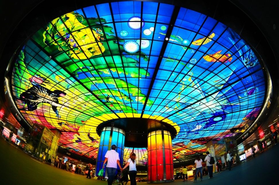
Taiwan
## Description The **Dome of Light (光之穹頂)** is one of the most breathtaking examples of public art in the world, transforming an ordinary metro station into a dazzling celebration of color, light, and human creativity. Located inside the **Formosa Boulevard Station** in **Kaohsiung**, Taiwan’s second-largest city, the Dome of Light is the **largest glass artwork in the world**, covering over **660 square meters** and made up of **4,500 individual glass panels**. Created by Italian artist **Narcissus Quagliata**, the dome was completed in **2008** as part of Kaohsiung’s Mass Rapid Transit (MRT) system. The artwork tells a powerful story of **human life and cosmic unity**, divided into four sections that symbolize the cycle of existence — **Water (birth), Earth (growth), Light (creativity),** and **Fire (destruction and rebirth)**. The vibrant interplay of colors and light gives visitors the feeling of standing inside a living, glowing painting. What makes the Dome of Light truly special is its emotional resonance. Beyond its visual impact, the dome serves as a **symbol of peace and hope**, inspired by Taiwan’s journey toward democracy. The artist worked closely with Taiwanese glass artisans to ensure every piece reflected the spirit of the island — a lesser-known fact that adds to the dome’s cultural depth. Another interesting detail is that the glass was **handcrafted and colored in Germany**, then carefully assembled in Kaohsiung, taking **nearly four years** to complete. When the dome is illuminated at night or during special light shows, it becomes an immersive experience that draws both locals and international visitors. Whether you’re a commuter or a traveler, standing beneath this glowing ceiling feels like entering a world suspended between art and the cosmos. ## Location The Dome of Light is located in **Formosa Boulevard Station (美麗島站)**, the interchange between the **Red and Orange lines** of the **Kaohsiung MRT** system, in **Kaohsiung City**, **southern Taiwan**. To get there: * **By MRT:** Take the **Red Line** or **Orange Line** to **Formosa Boulevard Station**. The dome is located in the main concourse between the platforms. * **From Kaohsiung Railway Station:** Just one stop south on the Red Line. * **From Kaohsiung International Airport:** Take the Red Line northbound — it’s about a **15-minute ride**. The site is indoors and accessible year-round, making it a convenient stop for travelers exploring the city. ## Tips * **Visit during the evening:** The lighting is most vivid after sunset, and you may catch the **light and sound show**, which runs periodically throughout the evening. * **Allow time to stand and observe:** Don’t rush — the dome’s storytelling elements unfold as you walk around the circular space. * **Photography:** Tripods are not allowed, but handheld photography is welcome. Try standing at the center for a symmetrical view. * **Combine with local attractions:** The **Liuhe Night Market** is only a short walk away — perfect for dinner after your visit. * **Look for performances:** Occasionally, local musicians and artists perform under the dome, enhancing the atmosphere. * **Best time to avoid crowds:** Early morning or late at night, when commuter traffic is low. ## Conclusion The **Dome of Light** is more than a stunning piece of art — it’s a symbol of creativity, peace, and transformation that perfectly reflects Taiwan’s modern cultural spirit. Blending Italian artistry with Taiwanese craftsmanship, it turns an urban metro station into a place of wonder and contemplation. Whether you’re passing through Formosa Boulevard or making a special trip, standing beneath its radiant glass ceiling is an experience that will stay with you long after you’ve left Kaohsiung. ## FAQ **1. Who designed the Dome of Light?** It was designed by **Narcissus Quagliata**, an Italian artist known for his innovative work in glass and light. **2. When was it completed?** The Dome of Light was finished in **2008** as part of Kaohsiung’s MRT construction project. **3. How big is it?** It covers **660 square meters (7,100 square feet)** and consists of over **4,500 glass panels**, making it the largest glass dome in the world. **4. Where is it located?** Inside **Formosa Boulevard Station** in **Kaohsiung City**, Taiwan, at the intersection of the **Red and Orange MRT lines**. **5. Is there an entrance fee?** No, access to the Dome of Light is **free of charge**, even if you are not riding the metro. **6. Are there light shows?** Yes, **light and music shows** are held several times daily, especially in the evenings. Check the schedule at the station for show times. ## Links * [Dome of Light Taiwan](https://eng.taiwan.net.tw/m1.aspx?sNo=0002121&id=A12-00071)
GemVoyage Team • World
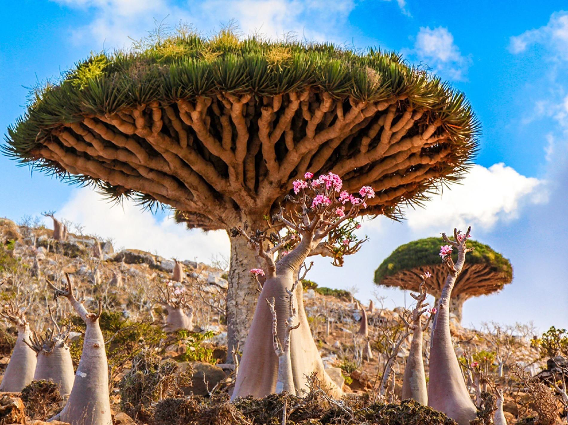
Socotra
## Description Socotra Island feels like a fragment of another planet — a remote, windswept archipelago in the northwest Indian Ocean whose flora and landscapes defy easy comparison. Part of Yemen’s Socotra Archipelago, the island is famed for its unique biodiversity: roughly one-third of its plant species are endemic, meaning they occur nowhere else on Earth. The emblematic dragon’s blood tree (Dracaena cinnabari) with its umbrella-like silhouette and deep red sap has become a symbol of Socotra’s otherworldly charm. Across the island, landscapes alternate between bizarre limestone plateaus, dramatic sea cliffs, windswept sand flats and pristine white-sand beaches framed by coral reefs. The experience of Socotra is defined by its isolation. Thousands of years of relative climatic stability have allowed life to evolve along separate lines, producing a cast of plants and small reptiles adapted to arid conditions and shallow soils. Visitors remark on the sculptural shapes and strange textures of the vegetation: bulbous succulents, twisted bottle trees, and dense thorny thickets that host endemic birds and invertebrates. This is a place for slow observation — botanizing on rock-strewn plateaus, watching seabirds along cliffs, and learning how local communities have adapted pastoral and fishing traditions to the island’s rhythms. Beyond flora and fauna, Socotra offers an immersive cultural layer. The island’s towns and villages, led by the main hub of Hadibo, display a traditional way of life that blends Bedouin pastoralism with fishing and small-scale commerce. Over the past decade eco-tourism has grown carefully: small guesthouses and locally guided tours emphasize conservation and community benefit. For the adventurous traveler the island’s remote tracks, sea caves and beaches promise solitude and dramatic light, perfect for landscape photography, contemplative walking and quiet wildlife encounters. ## Location Socotra is located in the northwest Indian Ocean, administratively part of Yemen, lying closer to the Horn of Africa than to the Arabian mainland. The island’s primary settlement and logistical hub is Hadibo (sometimes spelled Hadibu) on the northern coast. Historically, reaching Socotra has required careful planning: flights are limited and schedules change with political and logistical conditions. When available, small charter flights connect Socotra with mainland Yemen and, occasionally, regional hubs; sea access — via carefully arranged boat charters or local vessels — is an alternative for those with flexible timing. Because access can be intermittent, most independent travelers book through experienced operators who handle permits, inter-island travel, and local liaison. Visitors should check visa requirements and entry permits well in advance, and factor in contingency days for travel delays. Once on the island, Hadibo serves as the staging point for day trips inland to the Dixam Plateau, the Hagghier Mountains, and coastal excursions to remote beaches and snorkeling sites. ## Tips - **Check travel advisories and logistics:** Socotra’s access and safety status can change with regional developments. Before planning, consult official travel advisories, contact tour operators, and verify flight or sea schedules. Leave buffer days in your itinerary for unexpected delays. - **Use licensed local guides and operators:** Knowledgeable local guides are essential for navigating rocky tracks, interpreting plant life, and arranging transport to remote sites. Hiring local guide services supports the economy and ensures respectful interaction with communities. - **Respect fragile ecosystems:** Much of Socotra’s ecology is fragile. Stick to established tracks, avoid trampling vegetation, do not remove plants or geological material, and use minimal-impact camping practices. - **Pack for varied conditions:** Inland plateaus and mountains can be hot and dry during the day and chilly at night; coastal winds can be strong. Bring sun protection, sturdy hiking boots, a light windproof layer, and a reusable water bottle with a reliable purification method. - **Plan photography and drone use carefully:** Drones may be restricted to protect wildlife and privacy. Always ask local guides about regulations and cultural sensitivities before using camera equipment. - **Health and safety:** Medical facilities on Socotra are basic. Carry a well-stocked first-aid kit, any personal medications, and consider travel insurance with emergency evacuation coverage. Be up to date on routine vaccinations and check for recommended travel vaccines. - **Support local communities:** Choose guesthouses and guides that employ local staff, buy produce and crafts locally, and respect local dress and customs in villages. ## Conclusion Socotra is a destination for travelers who seek radical otherness and ecological rarity. Its alien plant forms, remote beaches, and quiet villages offer an experience both humbling and exhilarating — a reminder of how geographic isolation shapes life in remarkable ways. Thoughtful visitors who arrive well-prepared will find a landscape rich with photographic opportunities, quiet hiking routes, and meaningful encounters with local people and culture. Above all, Socotra rewards patience: time spent watching a dragon’s blood tree silhouette against the sky, or exploring a limestone plateau at dusk, lingers long after the trip ends. ## FAQ - **Q: Is Socotra safe to visit?** A: Safety and access can vary with regional and political conditions. Check up-to-date government travel advisories, consult experienced operators who run tours to Socotra, and register your travel plans with your embassy when appropriate. - **Q: How long should I spend on Socotra?** A: A well-paced visit typically runs 6–10 days. This allows time to explore the Dixam Plateau, the Hagghier Mountains, coastal beaches and a few village visits without feeling rushed. - **Q: When is the best time to visit Socotra?** A: The most comfortable travel window is during the cooler months, roughly October through April. Monsoon-related weather and hot summer temperatures can make travel more difficult in other months. - **Q: Can I arrange independent travel or do I need a tour operator?** A: Because flights and permits are limited, most travelers use reputable operators who arrange logistics, guides and permits. Independent travel is possible but requires local contacts and contingency planning. - **Q: What should I bring for wildlife and landscape photography?** A: Bring a mid-range zoom lens, a wide-angle for landscapes, a sturdy tripod for low-light work, spare batteries and memory cards, and neutral-density filters for coastal long exposures. - **Q: Are there accommodations and food options on the island?** A: Hadibo has small guesthouses and basic restaurants; expect simple but hearty local meals. For remote camping or multi-day excursions, operators typically supply food and equipment — confirm details beforehand. ## Links - [Socotra — Wikipedia](https://en.wikipedia.org/wiki/Socotra)
GemVoyage Team • World
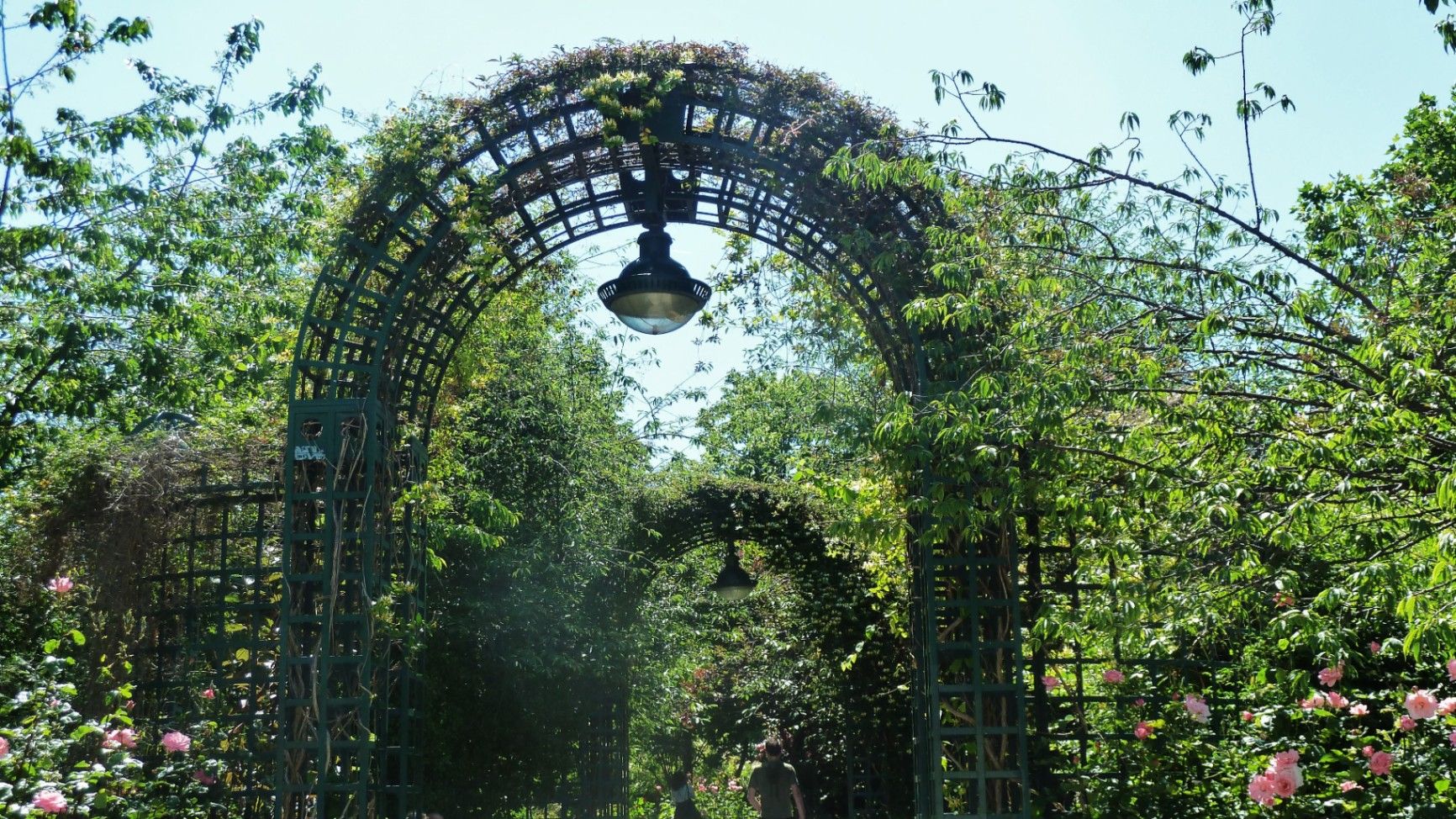
Paris
## Description The **Coulée Verte René-Dumont** is one of Paris’s most quietly transformative urban landscapes: a **4.7-kilometer elevated green corridor** built on a former 19th-century railway viaduct. Long before New York’s High Line became famous, Paris had already pioneered the idea of reclaiming industrial infrastructure and turning it into a **linear park suspended above city streets**. Opened in **1993**, the Coulée Verte stretches across eastern Paris, offering a continuous ribbon of trees, gardens, pergolas, tunnels, and walkways that float above neighborhoods, rooftops, and traffic. Rather than being a monumental tourist attraction, its strength lies in its **subtle intimacy**. The path winds between apartment balconies, over narrow streets, through shaded cuttings, and across stone viaducts, allowing visitors to experience Paris from an **unexpected vertical perspective**. The design philosophy of the park is deeply rooted in **soft landscaping rather than formal symmetry**. Instead of wide lawns or dramatic vistas, the Coulée Verte contains **layered vegetation, winding paths, seasonal flowers, bamboo groves, climbing roses, and shaded benches**. This makes it feel more like a secret garden than a grand urban park. One of the most remarkable architectural features of the route is the **Viaduc des Arts**, where the park runs along a series of brick arches originally built for railway use. Beneath these arches now sit artisan workshops, design studios, galleries, instrument makers, and boutique craftspeople. This dual-level experience—**green tranquility above and creative commerce below**—is one of the Coulée Verte’s defining identities. Unlike Paris’s grand axial parks such as the Tuileries or Luxembourg Gardens, the Coulée Verte offers a **continuously shifting urban narrative**. At one point, you are enclosed in forest-like silence; minutes later, you emerge into balcony-lined streets where residents drink coffee just meters away from your path. This creates an emotional tension between **privacy and exposure**, urban density and botanical escape. A little-known fact is that the park is named after **René Dumont**, a pioneering French agronomist and environmentalist who was also **France’s first Green Party presidential candidate**. The naming itself reinforces the park’s identity not just as a recreational space, but as a **symbol of ecological urban thinking**. Another little-known detail is that parts of the route pass directly behind residential buildings at eye level, leading to long-standing unspoken etiquette between walkers and residents regarding privacy. Today, the Coulée Verte is used daily by **joggers, dog walkers, commuters, couples, photographers, and elderly residents**, each group engaging with the space differently depending on time of day. Mornings are quiet and rhythmical. Afternoons bring families and visitors. Evenings soften into slow movement, conversation, and golden-hour light filtering through leaves onto brick and stone. The Coulée Verte does not dominate Paris visually or symbolically. Instead, it **slips through the city like a green seam**, quietly stitching nature into urban density. ## Location The **Coulée Verte René-Dumont** runs through the **12th arrondissement of Paris**, beginning near **Opéra Bastille** and extending eastward toward the **Périphérique (city ring road)**. **City:** Paris **Region:** Île-de-France **Country:** France **Primary Arrondissement:** 12th **Main Entrance Area:** Near Bastille and Avenue Daumesnil ### How to Get There: * **By metro:** * **Line 1, 5, or 8** to **Bastille Station** * **Line 6 or 8** to **Daumesnil Station** * **By RER:** **RER A** to **Nation Station**, then walk. * **By bus:** Multiple lines serve Avenue Daumesnil and the surrounding streets. * **By bicycle:** Easy access from eastern Paris cycle lanes. * **On foot:** Ideal as part of a walking route between Bastille, Bercy, and Nation. Multiple staircases and ramps provide access at different points along the route. ## Tips * **Walk the full length if possible:** The character of the park changes dramatically from west to east. * **Visit in spring or early autumn:** Vegetation is at its best and temperatures are comfortable. * **Early mornings are best for solitude:** Especially on weekdays. * **Evenings are best for atmosphere:** Soft lighting and slower rhythms dominate. * **Respect residential privacy:** Some sections run directly past apartment windows. * **Combine with Viaduc des Arts shopping:** The artisan shops beneath the arches are worth exploring. * **Bring water:** There are few vendors directly on the elevated path. * **Not ideal for fast cycling:** The path is narrow and shared heavily with pedestrians. ## Conclusion The **Coulée Verte René-Dumont** is not loud, monumental, or iconic in the traditional Parisian sense. Its power lies in **subversion and continuity**—a quiet green artery that transforms obsolete railway infrastructure into a flowing garden above the city. It offers a Paris of **movement, transition, and subtle beauty**, experienced not through grand monuments, but through shifting light, layered leaves, and elevated urban silence. ## FAQ **1. What is the Coulée Verte René-Dumont?** It is an **elevated linear park** built on an abandoned railway line in eastern Paris. **2. Is the Coulée Verte free to access?** Yes. It is **completely free and open to the public**. **3. How long does it take to walk the full route?** A full walk typically takes **1 to 1.5 hours** at a relaxed pace. **4. Is it similar to the High Line in New York?** Yes in concept, but the Coulée Verte is **older, greener, and more intimate** in character. **5. Is the park suitable for children?** Yes. It is widely used by families, though supervision is required in elevated or narrow sections. **6. Are there cafés or shops along the route?** Not directly on the path, but many cafés and bakeries are located at street level nearby. ## Links * [Paris City Guide](https://parisjetaime.com/eng/)
GemVoyage Team • World
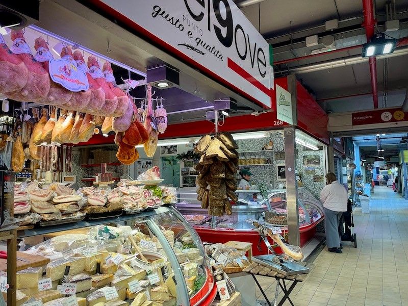
Rome
## Description Mercato Trionfale is one of Rome’s largest and most authentic food markets, offering visitors a deep dive into everyday Roman life. Unlike more tourist-oriented attractions, this bustling market is primarily frequented by locals who come here to shop for fresh produce, meats, cheeses, fish, baked goods, and household essentials. With more than 270 stalls spread across a modern covered structure, Mercato Trionfale is a feast for the senses and a perfect place to understand Rome’s food culture from the inside. What makes Mercato Trionfale especially unique is its balance between tradition and modernity. While many vendors represent families that have sold goods here for generations, the market has also embraced contemporary tastes, with stalls offering organic products, international foods, and ready-to-eat Roman street food. A little-known fact is that the market was originally an open-air street market before being moved in 2009 into its current eco-friendly building, designed to improve hygiene and sustainability. Another lesser-known detail is that some of Rome’s top chefs regularly source ingredients here, valuing the quality and personal relationships with vendors. For travelers who want to go beyond famous landmarks and experience Rome like a resident, Mercato Trionfale is well worth a visit. ## Location Mercato Trionfale is located in **Italy**, in the **Lazio** region, within the city of **Rome**. Specifically, it sits in the Trionfale district, just a short walk from Vatican City. The exact address is Via Andrea Doria 41, close to the Vatican Museums and St. Peter’s Basilica. Getting there is straightforward. The easiest way is by public transportation: take Metro Line A and get off at **Ottaviano – San Pietro** or **Cipro** stations, both of which are about a 5–10 minute walk from the market. Several bus lines also serve the area. If you are already visiting the Vatican Museums, Mercato Trionfale makes for an ideal stop before or after your visit. ## Tips * Visit in the morning, ideally between 9:00 and 11:00, when the market is most lively and fully stocked. * Bring cash, as some smaller vendors may not accept cards, though card payments are becoming more common. * Don’t hesitate to ask questions or request tastings; vendors are usually happy to explain their products, even with limited English. * Look for stalls selling cooked food if you want a quick, affordable lunch featuring classic Roman dishes like supplì, porchetta, or fresh pasta. * The market is closed on Sundays, so plan your visit accordingly. * Keep an eye on your belongings, as busy markets can attract pickpockets, especially during peak hours. ## Conclusion Mercato Trionfale is more than just a place to shop; it is a living snapshot of Roman daily life. With its vast selection of fresh food, welcoming vendors, and convenient location near the Vatican, it offers an authentic and memorable experience for anyone interested in Rome’s culinary traditions and local culture. ## FAQ **Is Mercato Trionfale tourist-friendly?** Yes, while it is mainly frequented by locals, visitors are welcome and generally well received. Many vendors are used to tourists and are patient and helpful. **What are the opening hours of Mercato Trionfale?** The market is typically open Monday to Saturday from early morning until around 2:30 PM, though hours may vary slightly by stall. **Can I eat at Mercato Trionfale?** Yes, several stalls sell ready-to-eat food, making it a great spot for a casual breakfast or lunch. **Is Mercato Trionfale expensive?** Prices are generally reasonable and often lower than in tourist-heavy areas, especially for fresh produce and local products. **How long should I plan to spend there?** Most visitors spend between 45 minutes and 1.5 hours, depending on whether they are shopping, eating, or just exploring. ## Links * [More Details](https://www.turismoroma.it/en/places/mercato-trionfale-local-market)
GemVoyage Team • World
Dublin
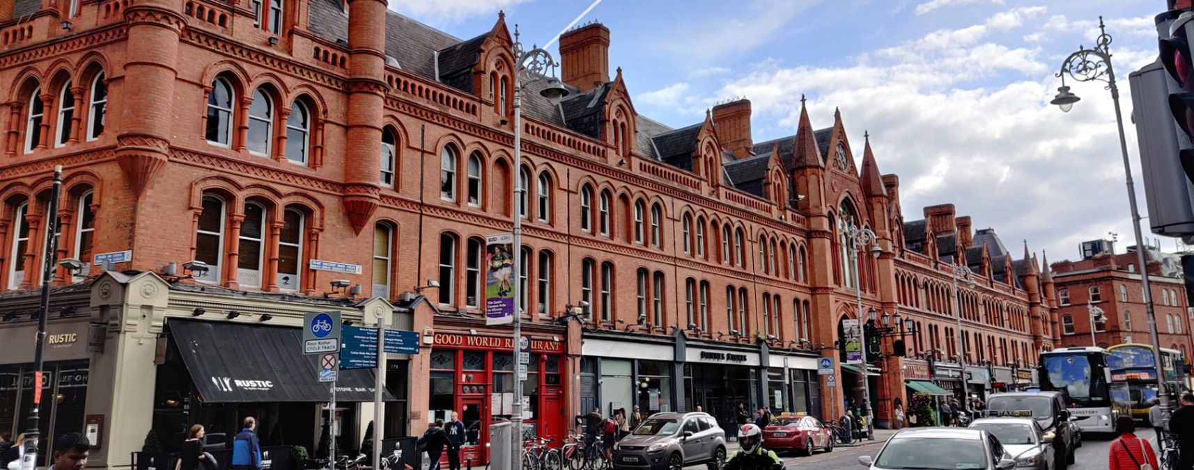
## Description **George’s Street Arcade (Stiúrtha Shráid Sheoirse)** is one of **Dublin’s oldest and most beloved shopping destinations**, offering a delightful blend of history, culture, and creativity. Opened in **1881**, it is one of the earliest purpose-built shopping arcades in Europe and remains a vibrant hub for both locals and visitors. Housed within a beautifully restored **Victorian red-brick structure**, the arcade features high wrought-iron arches, decorative glass roofing, and an atmosphere that blends the old with the contemporary. Inside, the narrow aisles are lined with an eclectic mix of independent stalls and boutique shops selling everything from vintage clothing and handmade jewelry to records, art, books, and collectibles. Street food vendors and cafés add delicious aromas to the air, making the experience as sensory as it is cultural. What makes George’s Street Arcade unique is its **authentic local character**—unlike chain-filled shopping centers, this market has remained fiercely independent for more than a century. It survived a major fire in 1892 and was rebuilt within two years, preserving its original charm. Another lesser-known fact is that the arcade was designed by English architects Lockwood & Mawson, the same team behind the iconic City Hall in Bradford, England. ## Location George’s Street Arcade is located in the heart of **Dublin City Centre**, **Ireland**, on **South Great George’s Street**, between Dame Street and Drury Street. Its central position places it just a few minutes’ walk from popular landmarks such as **Grafton Street**, **Trinity College**, and **Temple Bar**. To get there: * **On foot:** If you’re already exploring the city center, the arcade is within easy walking distance of most attractions. * **By public transport:** Take the **Luas Green Line** to the St. Stephen’s Green stop, or use Dublin Bus routes that pass through Dame Street or Aungier Street. * **By car:** Parking is available at nearby car parks such as Drury Street Car Park, though walking or public transport is recommended due to limited city parking. ## Tips * **Visit in the morning or early afternoon:** Crowds are smaller, and shop owners often have time to chat and share stories about their wares. * **Bring cash:** While many stalls accept cards, some smaller traders prefer cash for quick transactions. * **Try local snacks:** Sample treats from the market cafés — popular picks include crepes, pastries, or locally roasted coffee. * **Look for vintage and handmade goods:** The arcade is known for its one-of-a-kind finds, especially clothing, vinyl, and jewelry. * **Photography tip:** The interior’s glass roof and iron arches make for stunning photos, especially when sunlight filters through the skylights. * **Explore nearby:** After your visit, stroll along South William Street or George’s Street for more indie boutiques, pubs, and street art. ## Conclusion **George’s Street Arcade** is a living piece of Dublin’s history — a place where Victorian architecture meets contemporary creativity. Whether you’re shopping for a unique souvenir, enjoying local food, or simply soaking in the lively ambiance, this market captures the essence of Dublin’s independent spirit. It’s not just a shopping destination; it’s an experience that connects the city’s past with its ever-evolving present. ## FAQ **1. When was George’s Street Arcade built?** It was originally opened in 1881 and rebuilt in 1894 after a devastating fire. **2. What can I buy there?** The arcade offers handmade crafts, vintage fashion, jewelry, books, vinyl records, art, souvenirs, and local food. **3. Is there an entrance fee?** No, entry to the arcade is free for all visitors. **4. What are the opening hours?** Typically open **Monday to Saturday from 9:30 a.m. to 6:00 p.m.** and **Sunday from 12:00 p.m. to 6:00 p.m.**, though hours can vary slightly by shop. **5. Can I find local Irish products?** Yes — many vendors sell handcrafted Irish goods, from Celtic jewelry and wool accessories to local artwork and artisan foods. **6. Is it wheelchair accessible?** Yes, the main entrances and interior walkways are accessible, though some smaller stalls may have tight spaces. ## Links * [Official George’s Street Arcade Website](https://www.georgesstreetarcade.ie) * [Visit Dublin – George’s Street Arcade](https://www.visitdublin.com)
GemVoyage Team • World
.jpg)
Chongqing
## Description Jiefangbei Shopping Street, also known as **Jiefangbei Pedestrian Street**, is one of the most famous commercial districts in China and the beating heart of **Chongqing**. This bustling area is not just a shopping paradise but also a cultural and social hub, attracting millions of visitors every year. It combines luxury boutiques, international brands, local shops, trendy cafés, and street food stalls—all wrapped in the energetic atmosphere of one of China’s fastest-growing cities. At the center of the district stands the **Jiefangbei Monument (Liberation Monument)**, a historic landmark originally built in 1945 to commemorate China’s victory in World War II. Over time, the monument became surrounded by skyscrapers, neon lights, and high-end malls, symbolizing Chongqing’s transformation from a wartime city into a modern metropolis. A little-known fact is that Jiefangbei Shopping Street is often referred to as the **“Times Square of Chongqing”** due to its massive LED screens, vibrant nightlife, and crowds of visitors. Another unique detail is that beneath the pedestrian street lies a **complex underground shopping mall**, where visitors can explore an entire network of shops, restaurants, and entertainment venues. ## Location Jiefangbei Shopping Street is located in the **Yuzhong District of Chongqing, China**, right in the heart of the city’s central business area. Its central location makes it not only a shopping hotspot but also a starting point for exploring Chongqing’s rich culture and modern lifestyle. ### Recommendation on How to Get There The easiest way to reach Jiefangbei is by **metro**. Take **Line 2 or Line 6** of the Chongqing Metro and get off at **Xiaoshizi Station** or **Jiaochangkou Station**, both of which are just a short walk from the monument. Taxis are also widely available, but due to traffic congestion in the area, the metro is often faster and more convenient. For those staying in central hotels, the street is within easy walking distance. ## Tips Here are some useful tips to make the most of your visit to Jiefangbei Shopping Street: * **Shop Smart**: You’ll find everything from international luxury brands to local fashion boutiques. Bargaining is not common in malls but may be possible at smaller shops or street stalls. * **Try the Food**: Don’t miss the chance to taste Chongqing’s famous **spicy hotpot** or sample local street snacks like grilled skewers and spicy noodles. * **Visit at Night**: The area is most impressive in the evening when the neon lights illuminate the skyscrapers and the monument. * **Wear Comfortable Shoes**: The pedestrian street is large, and exploring the underground shopping centers can involve a lot of walking. * **Combine with Sightseeing**: From Jiefangbei, you can easily walk to **Hongya Cave**, a famous riverside complex, or take a short ride to the **Yangtze River Cableway**. * **Stay Aware of Crowds**: The area can get extremely busy, especially on weekends and holidays, so keep an eye on personal belongings. ## Conclusion Jiefangbei Shopping Street is more than just a commercial hub—it’s a cultural and social landmark that reflects Chongqing’s modern energy and historical roots. With its mix of shopping, dining, and entertainment options, along with the iconic Liberation Monument, it offers a truly immersive experience for both locals and tourists. Whether you’re hunting for the latest fashion trends, tasting local delicacies, or simply soaking in the vibrant atmosphere, Jiefangbei is a must-visit destination in southwest China. ## FAQ **1. What is Jiefangbei Shopping Street famous for?** It is famous for its mix of luxury shops, local boutiques, food stalls, and the iconic Liberation Monument. **2. Is it only for shopping?** No, it’s also a cultural and entertainment hub, with restaurants, cafés, cinemas, and nightlife options. **3. When is the best time to visit Jiefangbei?** Evenings are the best, as the neon lights create a lively and colorful atmosphere. **4. How do I get there from Chongqing city center?** The easiest way is by metro, taking Line 2 or Line 6 to Xiaoshizi or Jiaochangkou stations. **5. Is Jiefangbei suitable for families?** Yes, families can enjoy shopping, dining, and sightseeing in the area. However, it can be crowded, so keeping an eye on children is important. **6. Are there hotels near Jiefangbei?** Yes, the area is surrounded by hotels ranging from luxury to budget options, making it convenient for tourists to stay nearby. ## Links * [Official Chongqing Tourism Office](https://www.china-tourism.de/en/provinces/chongqing/)
GemVoyage Team • World

Comments