GemVoyage Team • World
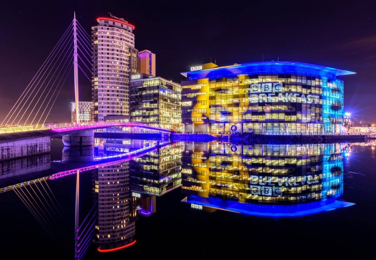
The Quays is one of Manchester’s most dynamic and visually striking waterfront areas, known for its blend of modern architecture, cultural landmarks, and leisure spaces. Once part of the historic Manchester Docks, this area has been completely transformed into a contemporary district that reflects the city’s industrial past while embracing innovation and creativity. Today, The Quays is a popular destination for both locals and visitors, offering museums, media hubs, restaurants, and scenic walking routes along the water.
What makes The Quays unique is its successful regeneration story. Formerly an active dock system that played a vital role in Britain’s industrial trade, the area fell into decline in the late 20th century before being reimagined as a cultural and media center. A little-known fact is that the docks here were once among the busiest inland ports in the world. Another interesting detail is that The Quays is home to MediaCityUK, where major broadcasters operate live studios, allowing visitors to see television and radio production happening in real time.
With iconic attractions such as The Lowry arts center and the Imperial War Museum North, The Quays offers a balanced mix of history, culture, and modern urban life.
The Quays is located in England, in the Greater Manchester region, within the city of Manchester, primarily spanning the Salford Quays area. It lies just west of Manchester city center, along the Manchester Ship Canal.
Getting to The Quays is easy and convenient. The Metrolink tram system provides direct access via stops such as MediaCityUK and Salford Quays, connecting the area to Manchester Piccadilly and other key parts of the city. Several bus routes also serve the area. For those arriving by car, parking is available at various nearby facilities, though public transport is often the most efficient option.
The Quays is a standout example of Manchester’s reinvention, transforming historic docks into a lively cultural and entertainment district. Its mix of museums, media, dining, and scenic walks makes it an essential stop for anyone exploring the city.
Is The Quays suitable for families?
Yes, the area is family-friendly, with open spaces, museums, and regular events suitable for all ages.
How much time should I spend at The Quays?
Most visitors spend between two and four hours, depending on activities and attractions visited.
Are there free attractions at The Quays?
Yes, attractions like the Imperial War Museum North offer free entry.
Is The Quays accessible for people with limited mobility?
Yes, the area is modern and generally well equipped with step-free access and wide pathways.
Can I eat and drink at The Quays?
Absolutely. The area offers a wide range of cafés, bars, and restaurants with waterfront views.
Discover more hidden gems you might love.
Plateliai
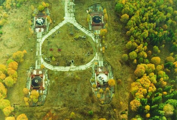
## Description The Plokštinė missile base, now preserved as the Cold War Museum near Plateliai, offers a rare and visceral encounter with twentieth-century strategic history. The site is a remarkably intact example of Soviet military engineering: deep underground launch tunnels, reinforced command bunkers, and surface infrastructure that hint at a wartime readiness now frozen in time. Unlike many museums that reconstruct events with replicas, Plokštinė retains original concrete, rusted metalwork, and patched wiring—materials that convey the scale and urgency of deterrence planning. What makes Plokštinė particularly compelling is its layered storytelling. Exhibits interweave technical descriptions of missile systems and launch protocols with human-scale narratives—photos of personnel, uniforms, diaries and municipal records that emphasize the lived experience of those stationed there. Guided tours often highlight operational details (how crews were rotated, how shelters were maintained) while reflecting on the broader geopolitical context: why land-based missile sites mattered to Soviet strategy and how their presence reshaped local communities. Conservation at Plokštinė has a museum-like rigor: lighting and interpretation are carefully placed to preserve fragile surfaces while enabling visitors to read inscriptions and see equipment. In the tunnels, the stone and concrete surfaces absorb sound, producing an almost cathedral-like hush that encourages reflection. The juxtaposition of heavy engineering and intimate domestic artifacts—the letter folded inside a pocket, a tea set on a service table—creates a human counterpoint to the site's strategic purpose. ## Location Plokštinė sits in western Lithuania near the small town of Plateliai in the Plungė district (Telšiai County), set against the pine and mixed-forest landscapes of Žemaitija National Park. The remoteness is part of the site’s character: the base was intentionally sited away from population centers, hidden by terrain and vegetation. Visitor research note: Scholars and Cold War enthusiasts should contact the museum ahead of time if they plan to consult archival materials or request deeper access for research purposes. Curators sometimes facilitate focused visits or point researchers toward local archives and oral-history resources that provide fuller context. How to get there: the most practical way to visit is by car, with the drive from Plateliai or Plungė taking under an hour depending on route and conditions. Local tour operators in Plateliai sometimes offer organized visits, which can include transport and guided interpretation. Public transport is sporadic — taxis from Plateliai or Plungė are the pragmatic alternative for visitors without private vehicles. Be mindful that signage outside the immediate museum area can be limited; bring offline maps or GPS coordinates when traveling. ## Tips - Book guided tours in advance when possible; on-site staff provide technical context and safety briefings that enhance understanding. - Dress for underground conditions: temperatures in tunnels are lower and the ground can be uneven and damp; sturdy shoes and a light jacket are recommended. - Respect restricted areas and posted rules; some sections may be closed to preserve sensitive structures or materials. - Photography: allowed in many parts, but check signage for restrictions in operational or fragile zones; avoid flash where plaster or pigments may be vulnerable. - Combine the visit with natural attractions: Plateliai Lake and Žemaitija National Park are nearby and make for a well-rounded day trip. - Bring water and snacks, as amenities near the site are limited; local cafes in Plateliai provide a pleasant break before or after a tour. ## Conclusion The Plokštinė Cold War Museum is a vivid public history site where engineering, geopolitics, and local memory intersect. It invites visitors to slow down and consider the practical technologies of deterrence alongside the human routines that sustained a military outpost. For scholars, photographers, and travelers interested in Cold War heritage, Plokštinė offers an uncommonly honest look at a world that once revolved around secrecy and rapid readiness. ## FAQ Q: Can visitors go inside the missile tunnels? A: Yes—guided tours typically include accessible sections of the underground complex. Access depends on safety conditions and conservation work, so check current availability and any age or mobility restrictions before you travel. Q: How long should I plan for a visit? A: Plan for at least two hours to experience the museum and tunnels at a relaxed pace; a guided tour plus time to read exhibits and explore surface ruins may take three hours. Q: Are tours available in English? A: Some tours and interpretive materials are available in English, but availability varies. Contact the museum or local tourism offices for the current language options and to request an English-speaking guide. Q: Is Plokštinė suitable for children? A: Older children and teens typically find the site fascinating, especially with a guide to explain technical details. Very young children may find confined spaces and sombre themes unsettling; consider the itinerary and their comfort. Q: Is the site accessible for visitors with reduced mobility? A: The underground and older structures have limited accessibility due to stairs, uneven surfaces, and narrow corridors. Visitors with mobility concerns should contact the museum ahead of time to discuss options and view accessible areas. ## Links - [Plokštinė missile base / Cold War Museum](https://coldwarsites.net/country/lithuania/plokstine-missile-base-museum-of-cold-war-plateliai/)
GemVoyage Team • World
.jpg)
Chongqing
## Description Jiefangbei Shopping Street, also known as **Jiefangbei Pedestrian Street**, is one of the most famous commercial districts in China and the beating heart of **Chongqing**. This bustling area is not just a shopping paradise but also a cultural and social hub, attracting millions of visitors every year. It combines luxury boutiques, international brands, local shops, trendy cafés, and street food stalls—all wrapped in the energetic atmosphere of one of China’s fastest-growing cities. At the center of the district stands the **Jiefangbei Monument (Liberation Monument)**, a historic landmark originally built in 1945 to commemorate China’s victory in World War II. Over time, the monument became surrounded by skyscrapers, neon lights, and high-end malls, symbolizing Chongqing’s transformation from a wartime city into a modern metropolis. A little-known fact is that Jiefangbei Shopping Street is often referred to as the **“Times Square of Chongqing”** due to its massive LED screens, vibrant nightlife, and crowds of visitors. Another unique detail is that beneath the pedestrian street lies a **complex underground shopping mall**, where visitors can explore an entire network of shops, restaurants, and entertainment venues. ## Location Jiefangbei Shopping Street is located in the **Yuzhong District of Chongqing, China**, right in the heart of the city’s central business area. Its central location makes it not only a shopping hotspot but also a starting point for exploring Chongqing’s rich culture and modern lifestyle. ### Recommendation on How to Get There The easiest way to reach Jiefangbei is by **metro**. Take **Line 2 or Line 6** of the Chongqing Metro and get off at **Xiaoshizi Station** or **Jiaochangkou Station**, both of which are just a short walk from the monument. Taxis are also widely available, but due to traffic congestion in the area, the metro is often faster and more convenient. For those staying in central hotels, the street is within easy walking distance. ## Tips Here are some useful tips to make the most of your visit to Jiefangbei Shopping Street: * **Shop Smart**: You’ll find everything from international luxury brands to local fashion boutiques. Bargaining is not common in malls but may be possible at smaller shops or street stalls. * **Try the Food**: Don’t miss the chance to taste Chongqing’s famous **spicy hotpot** or sample local street snacks like grilled skewers and spicy noodles. * **Visit at Night**: The area is most impressive in the evening when the neon lights illuminate the skyscrapers and the monument. * **Wear Comfortable Shoes**: The pedestrian street is large, and exploring the underground shopping centers can involve a lot of walking. * **Combine with Sightseeing**: From Jiefangbei, you can easily walk to **Hongya Cave**, a famous riverside complex, or take a short ride to the **Yangtze River Cableway**. * **Stay Aware of Crowds**: The area can get extremely busy, especially on weekends and holidays, so keep an eye on personal belongings. ## Conclusion Jiefangbei Shopping Street is more than just a commercial hub—it’s a cultural and social landmark that reflects Chongqing’s modern energy and historical roots. With its mix of shopping, dining, and entertainment options, along with the iconic Liberation Monument, it offers a truly immersive experience for both locals and tourists. Whether you’re hunting for the latest fashion trends, tasting local delicacies, or simply soaking in the vibrant atmosphere, Jiefangbei is a must-visit destination in southwest China. ## FAQ **1. What is Jiefangbei Shopping Street famous for?** It is famous for its mix of luxury shops, local boutiques, food stalls, and the iconic Liberation Monument. **2. Is it only for shopping?** No, it’s also a cultural and entertainment hub, with restaurants, cafés, cinemas, and nightlife options. **3. When is the best time to visit Jiefangbei?** Evenings are the best, as the neon lights create a lively and colorful atmosphere. **4. How do I get there from Chongqing city center?** The easiest way is by metro, taking Line 2 or Line 6 to Xiaoshizi or Jiaochangkou stations. **5. Is Jiefangbei suitable for families?** Yes, families can enjoy shopping, dining, and sightseeing in the area. However, it can be crowded, so keeping an eye on children is important. **6. Are there hotels near Jiefangbei?** Yes, the area is surrounded by hotels ranging from luxury to budget options, making it convenient for tourists to stay nearby. ## Links * [Official Chongqing Tourism Office](https://www.china-tourism.de/en/provinces/chongqing/)
GemVoyage Team • World
Faro
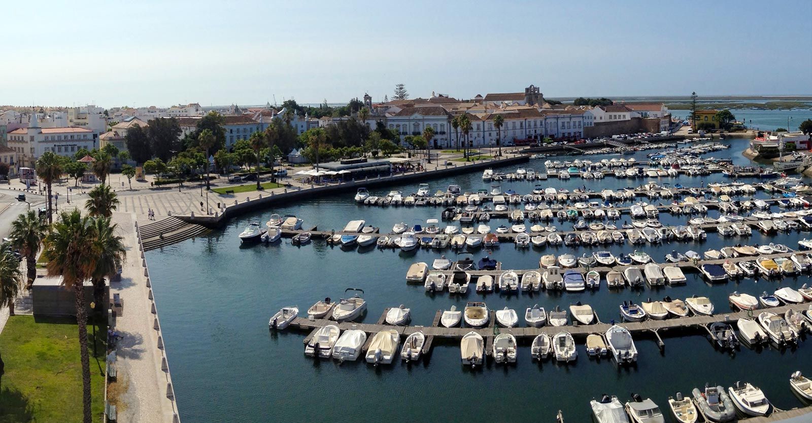
## Description Faro Marina is one of the most picturesque and lively spots in the Algarve region of southern Portugal. Nestled right in the heart of Faro, the marina is a central meeting point where the city’s charm blends seamlessly with its maritime heritage. With a backdrop of palm trees, elegant architecture, and rows of yachts and fishing boats bobbing gently on the water, it’s a place that embodies the relaxed yet vibrant spirit of coastal Portugal. What makes Faro Marina unique is not only its stunning scenery but also its role as a **gateway to the Ria Formosa Natural Park**, one of Portugal’s most beautiful protected lagoons. Many boat tours depart from the marina, offering visitors the chance to explore secluded islands, birdwatch, or enjoy a relaxing cruise at sunset. A little-known fact about Faro Marina is that the **large stork nests perched on lampposts and rooftops** around the harbor are a common sight, adding to its charm and making it a favorite spot for photographers. Another interesting detail is that the marina is often used for cultural events and festivals, turning it into a lively gathering point during summer evenings. ## Location Faro Marina is located in **Faro, the capital of the Algarve region in Portugal**. It sits right by the **city center**, just across from the historic old town and within walking distance of landmarks such as the **Arco da Vila** and **Faro Cathedral**. Its central location makes it a natural starting point for exploring both the city and the Algarve coastline. ### Recommendation on How to Get There From **Faro Airport**, the marina is only about a **10-minute drive** or a 15-minute bus ride on the airport shuttle. If you’re arriving by train or bus, both stations are within a short walking distance of the marina. For those exploring the Algarve by car, Faro is well-connected by road, and public parking is available near the city center. ## Tips Here are some helpful tips to make your visit to Faro Marina memorable: * **Take a Boat Tour**: Don’t miss the opportunity to explore the Ria Formosa islands, such as Ilha Deserta or Ilha do Farol, by booking a boat tour directly from the marina. * **Enjoy a Sunset Drink**: The waterfront is lined with cafés and bars—perfect for enjoying a glass of Portuguese wine or a cocktail while watching the sun go down. * **Photography Spot**: Bring your camera, especially for capturing the boats, the palm-fringed promenade, and the storks nesting nearby. * **Combine With Old Town Visit**: Since the marina is next to Faro’s historic district, combine your visit with a walk through cobbled streets, museums, and churches. * **Best Time to Visit**: Early evening is ideal, as the marina lights up beautifully, and the temperature is more comfortable during warmer months. * **Look Out for Events**: During summer, concerts, markets, and festivals are often held at or near the marina, adding extra vibrancy to your visit. ## Conclusion Faro Marina is more than just a harbor—it’s a cultural and social hub that captures the essence of Faro and the Algarve. With its stunning waterfront views, lively atmosphere, and easy access to natural wonders like the Ria Formosa, it’s a must-visit spot for anyone traveling to southern Portugal. Whether you’re taking a boat tour, enjoying a drink by the water, or simply strolling along the promenade, Faro Marina is sure to leave a lasting impression. ## FAQ **1. What can I do at Faro Marina?** You can enjoy boat tours to the Ria Formosa islands, dine at waterfront cafés, attend local events, or simply relax and admire the views. **2. Is Faro Marina close to the city center?** Yes, it’s located in the heart of Faro and is within walking distance of the historic old town and main transport hubs. **3. Are boat tours available year-round?** Yes, although availability and schedules may vary depending on the season. Summer offers the widest selection of tours. **4. Is it family-friendly?** Absolutely. The marina is pedestrian-friendly and offers plenty of open space, making it great for families with children. **5. Can I see wildlife at the marina?** Yes, you’ll often spot storks nesting nearby, and boat tours will take you to the Ria Formosa lagoon, which is rich in birdlife. **6. How long should I plan to spend at Faro Marina?** A casual visit might take an hour, but if you’re combining it with a boat trip and old town exploration, plan for half a day or more. ## Links * [Official Faro Tourism Office](https://www.faro.pt/en)
GemVoyage Team • World
.jpg)
Scotland
## Description The Fairy Pools on the Isle of Skye in Scotland are a series of crystal-clear, aqua-blue pools and cascading waterfalls that tumble down from the foothills of the Black Cuillin mountains. These natural pools, fed by the Allt Coire a’ Mhadaidh stream, are renowned for their ethereal beauty and have become one of Skye’s most iconic and photographed attractions. Whether you're a hiker, wild swimmer, or simply a lover of dramatic landscapes, the Fairy Pools offer a magical experience that feels straight out of folklore. The walk to the pools is relatively short—about 2.4 kilometers round trip—and follows a well-maintained gravel path that winds through heather-covered moorland. Along the way, visitors encounter a series of waterfalls and pools, each more striking than the last. The water is so clear that you can see the rocky bottoms and reflections of the surrounding hills, making it a favorite spot for photographers and nature enthusiasts. A little-known fact: the area around the Fairy Pools was the site of the last and bloodiest clan battle in Scottish history—the Battle of Coire na Creiche in 1601 between the MacLeods of Dunvegan and the MacDonalds of Sleat. Legend has it that the stream ran red with blood, a stark contrast to its current tranquil appearance. Another quirky detail is that despite their name, there’s no historical association with fairies—the name “Fairy Pools” only began appearing in guidebooks in the 20th century. ## Location The Fairy Pools are located in **Scotland**, on the **Isle of Skye**, near the village of **Carbost** in the **Highland region**. They sit at the base of the Black Cuillin mountains in **Glen Brittle**, on the western side of the island. ### How to Get There - **By Car**: From Portree, the island’s main town, it’s about a 30-minute drive (20.5 miles) via the B8009 and Glenbrittle road. The route includes single-track roads with passing places. - **By Bus**: Public transport is limited. Buses run to Carbost, but you’ll need to arrange a taxi or walk from there. - **By Tour**: Several guided tours from Portree or Inverness include the Fairy Pools as part of a day trip. - **By Foot**: The walk to the pools begins at the Fairy Pools car park, located near Glenbrittle. From the car park, it’s a 20-minute walk to the first waterfall. ## Tips - **Visit Early or Late**: The site gets crowded during peak hours, especially in summer. Early morning or late afternoon offers better light and fewer visitors. - **Wear Waterproof Footwear**: The path can be muddy and uneven, especially after rain. - **Bring Layers**: Weather on Skye is unpredictable. Pack a waterproof jacket and warm clothing. - **Wild Swimming**: Brave souls can swim in the pools, but the water is icy year-round. A wetsuit is recommended. - **Respect Nature**: Follow the Scottish Outdoor Access Code—take your litter with you and stick to marked paths. - **Parking**: There is a charge for parking at the Fairy Pools car park, which helps maintain the site. ## Conclusion The Fairy Pools on the Isle of Skye are a breathtaking blend of natural beauty and Highland mystique. With their vivid waters, dramatic mountain backdrop, and rich history, they offer a memorable experience for anyone exploring Scotland’s rugged landscapes. ## FAQ **1. Is there an entrance fee to visit the Fairy Pools?** No, the pools are free to visit, but there is a charge for parking. **2. How long is the walk to the Fairy Pools?** The round-trip walk is approximately 2.4 kilometers and takes 40 minutes to 1.5 hours depending on pace and stops. **3. Can I swim in the Fairy Pools?** Yes, wild swimming is allowed, but the water is extremely cold. A wetsuit is recommended. **4. Are the Fairy Pools suitable for children?** Yes, but children should be supervised due to uneven terrain and cold water. **5. Is the site wheelchair accessible?** No, the terrain is rugged and includes steep inclines, making it unsuitable for wheelchairs. **6. What is the best time of year to visit?** Spring and autumn offer mild weather and fewer crowds. Summer is busiest, while winter can be icy and less accessible. ## Links - [Fairy Pools Walk – Isle of Skye Guide](https://www.isleofskye.com/skye-guide/top-ten-skye-walks/fairy-pools) - [Fairy Pools – VisitScotland Overview](https://www.visitscotland.com/info/see-do/fairy-pools-p1770011) - [Fairy Pools – Wikipedia Entry](https://en.wikipedia.org/wiki/Fairy_Pools) Description The Fairy Pools on the Isle of Skye in Scotland are a series of crystal-clear, aqua-blue pools and cascading waterfalls that tumble down from the foothills of the Black Cuillin mountains. These natural pools, fed by the Allt Coire a’ Mhadaidh stream, are renowned for their ethereal beauty and have become one of Skye’s most iconic and photographed attractions. Whether you're a hiker, wild swimmer, or simply a lover of dramatic landscapes, the Fairy Pools offer a magical experience that feels straight out of folklore. The walk to the pools is relatively short—about 2.4 kilometers round trip—and follows a well-maintained gravel path that winds through heather-covered moorland. Along the way, visitors encounter a series of waterfalls and pools, each more striking than the last. The water is so clear that you can see the rocky bottoms and reflections of the surrounding hills, making it a favorite spot for photographers and nature enthusiasts. A little-known fact: the area around the Fairy Pools was the site of the last and bloodiest clan battle in Scottish history—the Battle of Coire na Creiche in 1601 between the MacLeods of Dunvegan and the MacDonalds of Sleat. Legend has it that the stream ran red with blood, a stark contrast to its current tranquil appearance. Another quirky detail is that despite their name, there’s no historical association with fairies—the name “Fairy Pools” only began appearing in guidebooks in the 20th century. Location The Fairy Pools are located in Scotland, on the Isle of Skye, near the village of Carbost in the Highland region. They sit at the base of the Black Cuillin mountains in Glen Brittle, on the western side of the island. How to Get There By Car: From Portree, the island’s main town, it’s about a 30-minute drive (20.5 miles) via the B8009 and Glenbrittle road. The route includes single-track roads with passing places. By Bus: Public transport is limited. Buses run to Carbost, but you’ll need to arrange a taxi or walk from there. By Tour: Several guided tours from Portree or Inverness include the Fairy Pools as part of a day trip. By Foot: The walk to the pools begins at the Fairy Pools car park, located near Glenbrittle. From the car park, it’s a 20-minute walk to the first waterfall. Tips Visit Early or Late: The site gets crowded during peak hours, especially in summer. Early morning or late afternoon offers better light and fewer visitors. Wear Waterproof Footwear: The path can be muddy and uneven, especially after rain. Bring Layers: Weather on Skye is unpredictable. Pack a waterproof jacket and warm clothing. Wild Swimming: Brave souls can swim in the pools, but the water is icy year-round. A wetsuit is recommended. Respect Nature: Follow the Scottish Outdoor Access Code—take your litter with you and stick to marked paths. Parking: There is a charge for parking at the Fairy Pools car park, which helps maintain the site. Conclusion The Fairy Pools on the Isle of Skye are a breathtaking blend of natural beauty and Highland mystique. With their vivid waters, dramatic mountain backdrop, and rich history, they offer a memorable experience for anyone exploring Scotland’s rugged landscapes. FAQ 1. Is there an entrance fee to visit the Fairy Pools? No, the pools are free to visit, but there is a charge for parking. 2. How long is the walk to the Fairy Pools? The round-trip walk is approximately 2.4 kilometers and takes 40 minutes to 1.5 hours depending on pace and stops. 3. Can I swim in the Fairy Pools? Yes, wild swimming is allowed, but the water is extremely cold. A wetsuit is recommended. 4. Are the Fairy Pools suitable for children? Yes, but children should be supervised due to uneven terrain and cold water. 5. Is the site wheelchair accessible? No, the terrain is rugged and includes steep inclines, making it unsuitable for wheelchairs. 6. What is the best time of year to visit? Spring and autumn offer mild weather and fewer crowds. Summer is busiest, while winter can be icy and less accessible. Links Fairy Pools Walk – Isle of Skye Guide Fairy Pools – VisitScotland Overview Fairy Pools – Wikipedia Entry 715 words37 lines4484 characters4520 bytes
GemVoyage Team • World
Bremen
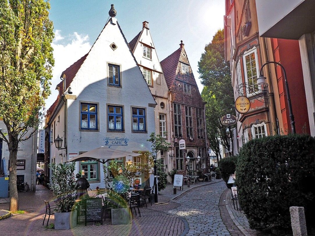
## Description The Schnoor is Bremen’s oldest quarter and one of the most picturesque areas in northern Germany. Walking through its narrow, winding alleyways feels like stepping into a medieval painting. The quarter is filled with tiny half-timbered houses, dating mostly from the 15th to 18th centuries, which have been lovingly preserved and restored. These charming homes are now a mix of cafés, artisan shops, galleries, and small museums that invite visitors to explore at a leisurely pace. What makes the Schnoor especially unique is its compact layout. The name “Schnoor” comes from the Low German word for “string” or “cord,” reflecting the fact that rope- and cord-makers once lived and worked here. The streets are so narrow in places that two people can barely walk side by side, a reminder of how space was used in medieval times. A little-known fact is that Schnoor was once considered a poor district of Bremen, inhabited mainly by fishermen and craftsmen. Today, however, it is one of the city’s most visited and beloved neighborhoods. Another interesting detail is that many of the houses are not perfectly aligned but instead lean slightly, giving the streets a charmingly crooked look. These imperfections only add to the district’s authentic, lived-in atmosphere, making it a favorite for photographers and history enthusiasts alike. ## Location The Schnoor is located in the heart of **Bremen**, a city in the state of **Bremen** in northwestern **Germany**. More precisely, it lies close to the Weser River and only a short walk from Bremen’s famous Market Square (Marktplatz), where the UNESCO World Heritage-listed Town Hall and Roland statue stand. Getting to the Schnoor is straightforward. If you are arriving in Bremen by train, the district is about a 15-minute walk from Bremen Central Station. Trams and buses also stop near the city center, making the area very accessible. For visitors traveling from Hamburg, a direct train ride takes about one hour, making Schnoor a perfect day-trip destination. Walking is the best way to explore the quarter, as the narrow lanes are not accessible by car. ## Tips * **Visit early or late in the day:** The Schnoor can become crowded with tourists during peak hours. Early mornings or evenings offer a quieter experience. * **Bring a camera:** The crooked houses, colorful facades, and hidden courtyards provide endless photo opportunities. * **Don’t rush:** Many visitors walk through quickly, but the real magic lies in browsing small shops, enjoying a coffee in one of the cozy cafés, or discovering hidden details in the architecture. * **Check out cultural stops:** The Schnoor hosts several museums, including the Schifferhaus (House of Skippers), which tells the story of Bremen’s maritime history. * **Try local specialties:** Some bakeries and cafés offer regional treats like Bremer Klaben (a type of fruit bread) or traditional beer from local breweries. ## Conclusion The Schnoor in Bremen is more than just a historic district; it is a living time capsule where history, culture, and modern life meet in a uniquely charming way. With its narrow alleys, crooked houses, and rich maritime heritage, it is one of Bremen’s must-see attractions for any traveler seeking authenticity and atmosphere. ## FAQ **1. What is the Schnoor best known for?** The Schnoor is famous for its narrow medieval alleys, half-timbered houses, and its transformation from a poor fishermen’s quarter into a vibrant cultural and tourist district. **2. Is the Schnoor suitable for children?** Yes, children usually enjoy the fairy-tale-like streets and quirky architecture. However, strollers might be difficult to maneuver in the narrowest lanes. **3. How long does it take to visit the Schnoor?** A quick walk-through can take 30 minutes, but to enjoy shops, cafés, and museums, plan for at least two to three hours. **4. Can cars enter the Schnoor?** No, the lanes are too narrow for cars. The area is best explored on foot. **5. Are guided tours available?** Yes, many guided walking tours of Bremen include the Schnoor. These tours provide fascinating insights into the district’s history and architecture. **6. Is the Schnoor open year-round?** Yes, the quarter is accessible throughout the year, though opening hours of shops and cafés vary. The winter months can be especially cozy, with festive decorations adding to the atmosphere. ## Links * [Official Tourism Page of Bremen](https://www.bremen-tourism.de) * [Visit Bremen – Schnoor District](https://www.bremen.de/tourism/schnoor)
GemVoyage Team • World
Amazonas
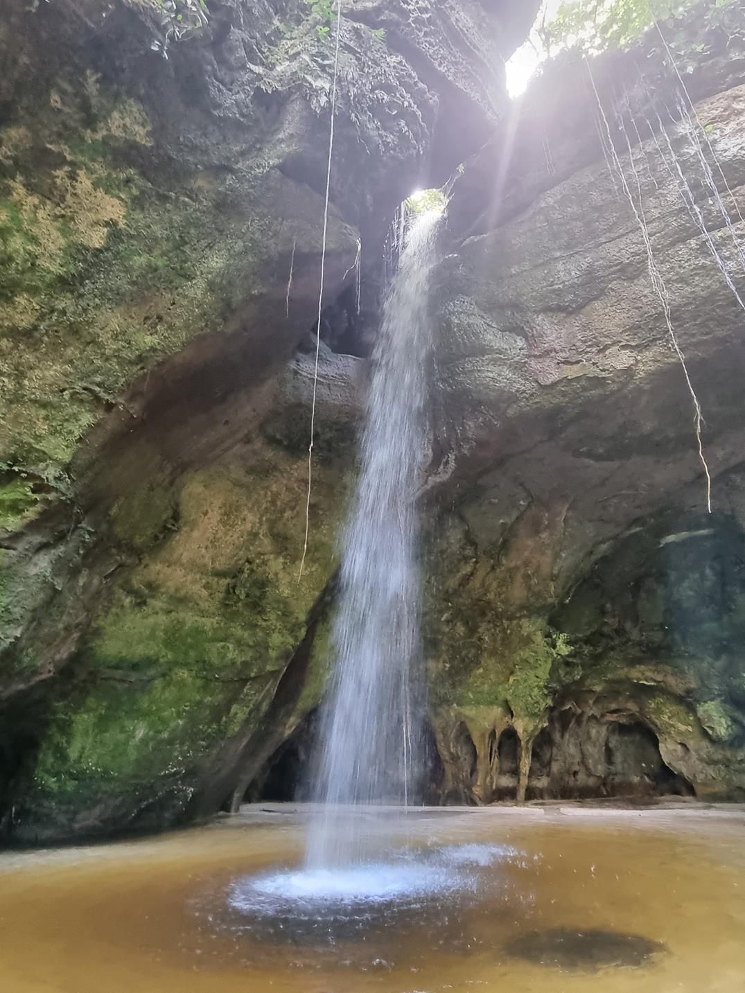
## Description Deep within the lush rainforest of the Amazon lies a pair of natural wonders: **Caverna do Maroaga (Maroaga Cave)** and **Caverna da Judeia (Judeia Cave)**. These caves are part of the Presidente Figueiredo municipality in northern Brazil, often nicknamed the “Land of Waterfalls and Caves” due to its unique geology and landscapes. The **Maroaga Cave** is famous for its dramatic sandstone formations and a stream that flows directly from within, creating a mystical atmosphere as the water emerges from the cave’s dark interior. Sunlight filtering through the forest canopy reflects on the water, giving the cave a magical glow. Its name comes from a local indigenous chief, Maroaga, who is said to have used the cave as a hideout, adding a layer of legend to its natural beauty. The nearby **Judeia Cave** is equally captivating. It features a more intimate setting, with a waterfall cascading over its entrance and forming a natural curtain of water. Walking behind the waterfall offers visitors a unique and refreshing perspective, with the sound of rushing water echoing throughout the cave. A little-known fact is that both caves are part of the same ecological reserve, which shelters a vast variety of flora and fauna. Biologists have recorded rare species of bats and amphibians in these caves, making them not only scenic wonders but also important ecological habitats. ## Location Caverna do Maroaga and Caverna da Judeia are located in **Presidente Figueiredo**, a municipality in the state of **Amazonas**, in northern **Brazil**. The region lies about 107 kilometers north of **Manaus**, the capital of Amazonas, along the BR-174 highway. The most common way to reach the caves is by car or organized tour from Manaus. The drive takes about two hours and passes through dense rainforest landscapes. Once at the entrance to the reserve, guided hikes of varying lengths lead to the caves. The trails are not particularly difficult, but they can be muddy and slippery, especially during the rainy season. For international visitors, the easiest route is to fly into Manaus and then book a day trip or multi-day tour that includes the caves as part of a broader itinerary of waterfalls and natural attractions. ## Tips * **Wear proper footwear:** Hiking boots or sturdy shoes are recommended, as the trails can be wet and uneven. * **Hire a guide:** Local guides not only ensure safety but also provide insights into the caves’ legends, geology, and biodiversity. * **Bring swimwear and a towel:** The waterfalls and streams around the caves are perfect for cooling off after a hike. * **Pack insect repellent:** The Amazon rainforest is home to mosquitoes and other insects, especially near water sources. * **Visit during the dry season:** From June to November, the trails are easier to access, although the rainy season offers stronger waterfalls and a wilder atmosphere. * **Respect the environment:** Avoid leaving litter, and do not disturb the caves’ wildlife, particularly bats and amphibians. ## Conclusion Caverna do Maroaga and Caverna da Judeia showcase the wild beauty and hidden wonders of Brazil’s Amazon rainforest. With their waterfalls, sandstone formations, and legendary history, they are must-visit sites for eco-tourists and adventurers seeking an authentic experience in the heart of nature. Together, they represent not just geological marvels but also living ecosystems that deserve protection and respect. ## FAQ **1. Do I need a guide to visit the caves?** Yes, local guides are highly recommended for safety, navigation, and to ensure the preservation of the natural environment. **2. Can I swim near the caves?** Yes, swimming is allowed in the pools and streams near the caves, but always follow local safety advice. **3. How difficult are the hikes to the caves?** The hikes are moderate in difficulty, with some slippery and uneven sections. Good footwear is essential. **4. Are the caves accessible year-round?** Yes, but the experience differs by season. The rainy season (December–May) offers stronger waterfalls, while the dry season (June–November) makes trails easier to navigate. **5. What wildlife might I see?** Bats, amphibians, tropical birds, and a wide variety of insects inhabit the area. Lucky visitors may even spot monkeys in the surrounding forest. **6. How long should I plan for a visit?** Most tours include both caves in a half-day excursion, though spending a full day allows more time to explore nearby waterfalls and trails. ## Links * [Amazons Wiki](https://en.wikipedia.org/wiki/Amazonas_(Brazilian_state))
GemVoyage Team • World

Comments