GemVoyage Team • World
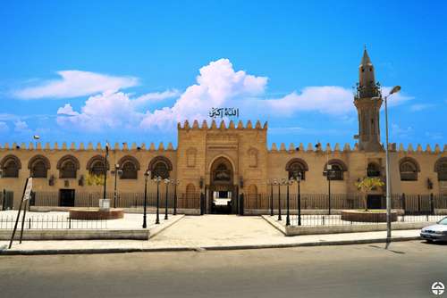
The Amr Ibn Al-Aas Mosque in Cairo is not just a religious site—it’s a living monument to the birth of Islam in Egypt and Africa. Built in 641–642 CE by General Amr Ibn Al-Aas following the Arab conquest of Egypt, it holds the distinction of being the first mosque ever constructed in Egypt and on the African continent. Originally erected in the newly founded city of Fustat, the mosque served as both a spiritual center and a gathering place for the early Muslim community.
Though the original structure was modest—little more than a roof supported by palm trunks—the mosque has undergone numerous renovations and expansions over the centuries. Today, it features a spacious courtyard, four minarets, and elegant arcades that reflect the evolution of Islamic architecture. Despite its many reconstructions, the mosque retains a sense of historical continuity and reverence.
A little-known fact: the site of the mosque was chosen in a rather poetic way. Legend has it that a dove laid an egg in Amr Ibn Al-Aas’s tent before he left for battle. Upon his victorious return, he interpreted the bird’s nest as a divine sign and built the mosque on that very spot. Another intriguing detail is that several companions of the Prophet Muhammad, including al-Zubayr ibn al-‘Awam and Ubada ibn al-Samit, participated in its construction.
The Amr Ibn Al-Aas Mosque is located in Egypt, within the Cairo Governorate, specifically in the historic district of Old Cairo (Al-Fustat). This area is rich in Islamic, Christian, and Jewish heritage, making it a cultural crossroads worth exploring.
To make the most of your visit to Amr Ibn Al-Aas Mosque, consider the following tips:
The Amr Ibn Al-Aas Mosque is more than just a place of worship—it’s a cornerstone of Islamic history in Africa. With its deep historical roots, architectural evolution, and spiritual significance, it offers visitors a profound glimpse into Egypt’s Islamic heritage and the early days of Fustat.
1. When was the Amr Ibn Al-Aas Mosque built?
It was originally constructed in 641–642 CE, making it the oldest mosque in Egypt and Africa.
2. Is the mosque still active today?
Yes, it remains an active place of worship and is open to visitors outside of prayer times.
3. Can non-Muslims visit the mosque?
Yes, non-Muslims are welcome, but should avoid entering during prayer times and dress respectfully.
4. Is there an entrance fee?
No, entry to the mosque is free, though donations for upkeep are appreciated.
5. What are the mosque’s opening hours?
Typically, it’s open from 9:00 AM to 4:00 PM, but hours may vary during religious holidays.
6. What other attractions are nearby?
Nearby sites include the Hanging Church, Ben Ezra Synagogue, and the Coptic Museum—all within walking distance.
Discover more hidden gems you might love.
Aswan
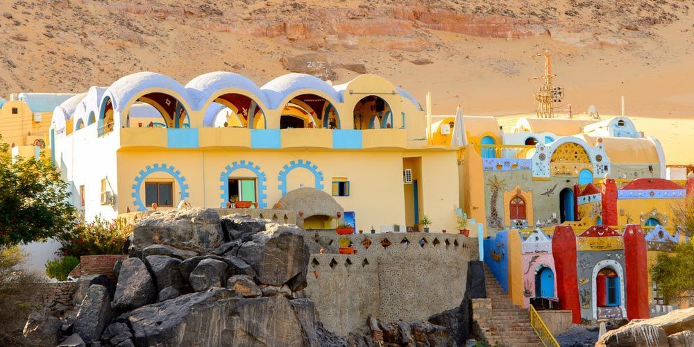
## Description The Nubian Village near Aswan is one of the most memorable cultural experiences in Upper Egypt. Famous for its bright houses, warm hospitality, and strong Nubian identity, the village offers visitors a chance to see a living culture that is distinct from the mainstream Egyptian tourist circuit. The colors of the buildings, the rhythm of the Nile, and the presence of local traditions create a setting that feels both welcoming and deeply rooted. What makes the Nubian Village special is that it is not merely a scenic stop. It is a place where everyday life, architecture, food, music, and crafts come together. Visitors often arrive expecting a photo opportunity and leave having learned about Nubian history, language, and resilience. The district's visual style is striking, with painted walls, decorative motifs, and domed or vaulted forms that reflect a practical response to climate as well as aesthetic preference. One lesser-known fact is that Nubian communities have faced major displacement over the 20th century, especially due to dam construction and changing river conditions, which makes cultural preservation particularly important. Another is that many decorative motifs on homes and walls are not random ornamentation; they often carry symbolic references to fertility, protection, heritage, or local storytelling. These details give the village a richness that rewards close observation. Food and hospitality are central to the experience. Meals may include local dishes, tea ceremonies, and conversations that help visitors understand the social fabric of the community. Music and handicrafts are also common parts of the visit, giving travelers a chance to see how traditions are maintained through daily practice rather than only through museums. The setting near the Nile adds another layer of beauty. The river shapes the village's pace and identity, and many visits include boat access or riverside views that connect the community to the wider Aswan landscape. This is not an isolated theme park version of culture; it is a place where river life, memory, and domestic space remain closely connected. For travelers who value cultural encounters over checklist tourism, the Nubian Village offers one of the most rewarding experiences in Aswan. It is colorful, welcoming, and meaningful, especially for visitors who take time to listen and engage respectfully. ## Location The Nubian Village is located near Aswan in southern Egypt, along the Nile River. It is associated with the Nubian communities of the Aswan area and is often reached by boat from the city or nearby riverfront points. The easiest way to visit is usually through a local boat transfer or an organized excursion from Aswan. Because access can vary depending on the exact village and seasonal river conditions, it is wise to confirm arrangements with a local guide or hotel before departure. ## Tips Bring small cash if you plan to buy crafts or refreshments, as small local purchases are common. Ask before taking close-up photos of people or private homes. Respectful behavior matters in a community setting. Go with a guide if you want a fuller understanding of Nubian history and symbolism. Try the local food or tea if offered, but do so in a way that feels thoughtful rather than rushed. Wear comfortable clothing suitable for warm weather and walking through village streets. Remember that the village is a living community, not just a tourist stop, so keep your pace and expectations respectful. ## Conclusion The Nubian Village near Aswan combines river scenery, cultural depth, and genuine hospitality, making it one of the most meaningful places to experience Nubian heritage in Egypt. ## FAQ ### What is the Nubian Village known for? It is known for colorful houses, Nubian culture, hospitality, crafts, and its setting along the Nile near Aswan. ### Can I visit the village independently? Often yes, but many visitors go by boat or with a guide to simplify access and improve the experience. ### Is it appropriate to take photos? Yes, but always ask before photographing people or private spaces. ### What should I buy there? Common souvenirs include crafts, textiles, and handmade items associated with Nubian culture. ## Links - [Aswan](https://en.wikipedia.org/wiki/Aswan)
GemVoyage Team • World
Barcelona
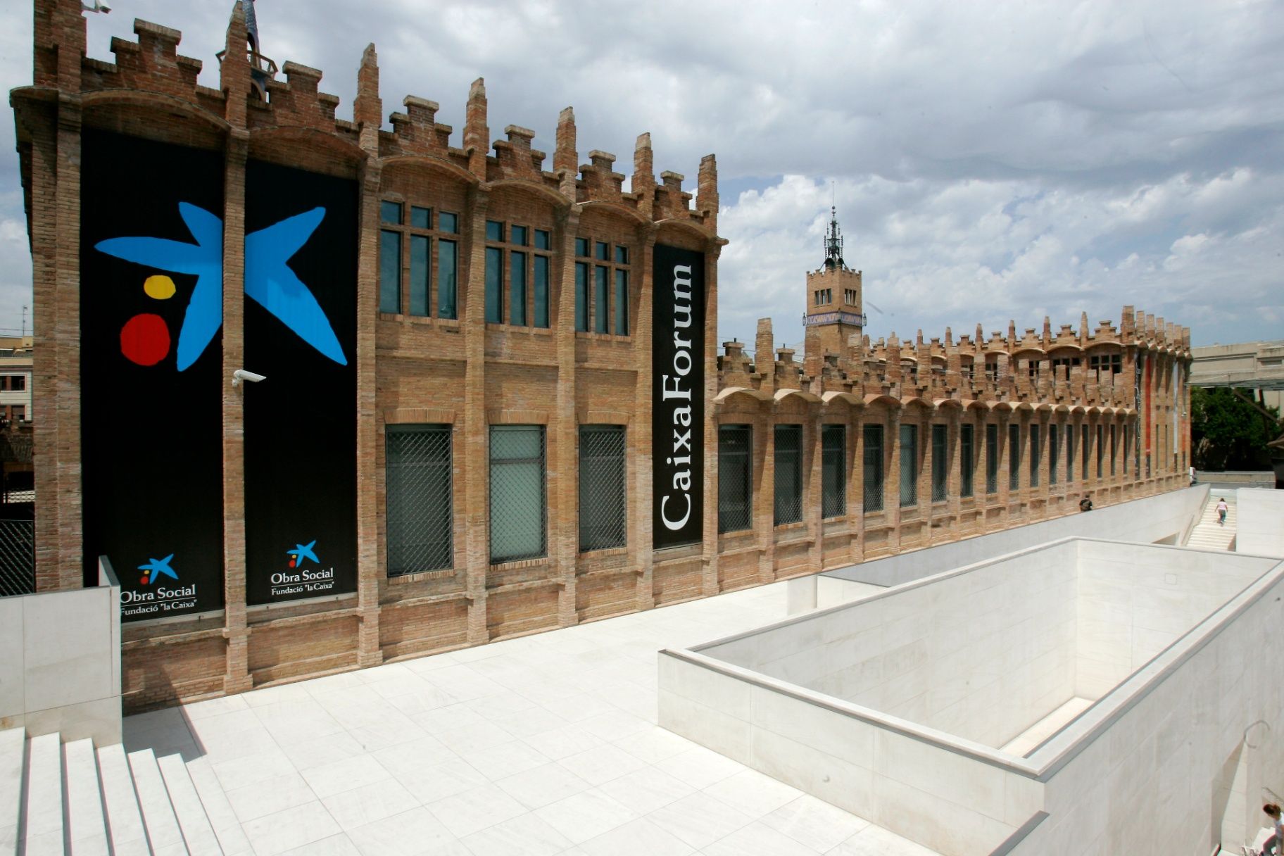
## Description **CaixaForum Barcelona** is one of the city’s most important cultural institutions, combining architecture, contemporary thought, and public education under one roof. It is housed in the former **Casaramona Textile Factory**, an early 20th-century industrial complex designed by the modernist architect Josep Puig i Cadafalch. Rather than demolishing the structure, it was carefully restored and repurposed, turning a once-abandoned factory into a vibrant center for exhibitions, debates, and artistic exploration. What makes CaixaForum Barcelona unique is its **programmatic diversity**. It is not a conventional museum with a permanent collection on display. Instead, it hosts a rotating schedule of high-quality temporary exhibitions covering art, photography, history, science, archaeology, music, and social issues. These exhibitions are often produced in collaboration with major international institutions, giving visitors access to works and ideas that rarely appear elsewhere in the city. Architecturally, the building itself is part of the experience. The red brick façades, sharp geometric volumes, and absence of ornamentation reflect a restrained form of Catalan modernism that contrasts with the more decorative style of Gaudí. A lesser-known fact is that the factory was originally built in 1911 but **never actually operated as an industrial plant**, as production ceased before it could fully open. Another interesting detail is the dramatic entrance plaza, redesigned by Japanese architect Arata Isozaki, which creates a striking dialogue between old and new through stone, steel, and light. Beyond exhibitions, CaixaForum functions as a **cultural forum in the literal sense**. It hosts lectures, film screenings, concerts, workshops, and family-oriented activities, making it appealing to a wide range of audiences. The institution emphasizes accessibility and education, aiming to make complex cultural topics understandable without oversimplifying them. ## Location **Country:** Spain **Region:** Catalonia **City:** Barcelona **District:** Sants-Montjuïc CaixaForum Barcelona is located at the foot of **Montjuïc Hill**, near Plaça d’Espanya, an area known for its concentration of museums, exhibition spaces, and monumental architecture. ### How to Get There * **By metro:** * Lines L1 (Red) or L3 (Green) to **Plaça d’Espanya** station. From there, it is a 5–7 minute walk. * **By bus:** * Several bus lines stop around Plaça d’Espanya and along Avinguda de Francesc Ferrer i Guàrdia. * **On foot:** * Easily reachable from Plaça d’Espanya and the surrounding exhibition grounds. * **By taxi:** * A convenient option if coming from other parts of the city; drop-off points are nearby. ## Tips * **Check the exhibition schedule in advance:** Exhibitions change regularly, and some are time-limited. * **Allow enough time:** One exhibition can easily take 90 minutes if explored thoroughly. * **Visit during weekdays:** Weekends tend to be busier, especially during popular exhibitions. * **Use the audio guides:** They provide context and depth without overwhelming the visitor. * **Combine with Montjuïc sights:** Pair your visit with nearby attractions such as museums or gardens. * **Look for free-entry times:** Certain days or time slots may offer reduced or free admission. ## Conclusion CaixaForum Barcelona is a cultural anchor that successfully bridges Barcelona’s industrial past with its intellectual present. Through its thoughtful exhibitions, adaptive architecture, and commitment to public engagement, it offers a meaningful alternative to traditional museums and rewards visitors seeking substance over spectacle. ## FAQ **1. Is CaixaForum Barcelona a museum?** It functions more as a cultural center with temporary exhibitions rather than a permanent museum collection. **2. How long does a visit usually take?** Most visitors spend between **1.5 and 3 hours**, depending on the exhibitions. **3. Is it suitable for children?** Yes, there are family-friendly exhibitions and interactive educational activities. **4. Are exhibitions available in multiple languages?** Yes, information panels and guides are usually available in Catalan, Spanish, and English. **5. Is the building accessible?** Yes, the center is fully accessible for visitors with reduced mobility. **6. Can you visit just for the architecture?** Yes, the building itself is worth seeing even without attending an exhibition. ## Links * [Official CaixaForum website](https://caixaforum.org/es/home)
GemVoyage Team • World
Berlin
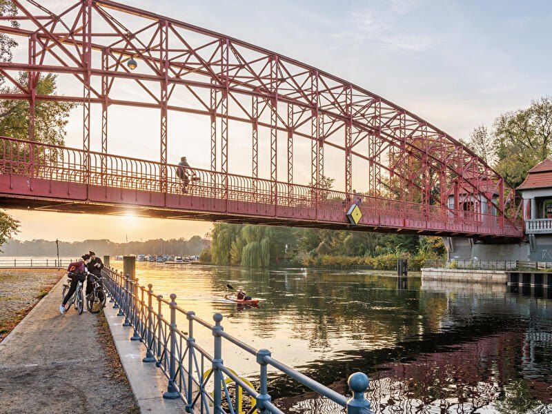
## Description **Tegeler See** is one of Berlin’s largest and most beloved lakes, offering a rare combination of **deep forest landscapes, wide open water, historic promenades, and recreational freedom** within a major European capital. Unlike the carefully curated parks of central Berlin, Tegeler See feels **expansive, natural, and quietly powerful**, a place where the city dissolves into wind, water, and tree canopy. The lake stretches across the northern edge of Berlin and forms part of a much larger **interconnected water system** linking rivers, canals, and smaller lakes. Its shoreline alternates between **elegant promenades, dense woodland, sandy bathing areas, hidden coves, and small harbors**, giving every section a distinct character. On one walk you might pass joggers and cyclists near cafés, and moments later find yourself alone on a forested shoreline with only birds and passing sailboats for company. What makes Tegeler See especially unique is its **scale and visual openness**. The lake is wide enough to feel almost coastal in certain sections. Wind patterns shape large ripples across the surface, and on clear days the sky reflects endlessly into the water. Sailboats, paddleboards, kayaks, ferries, and swimmers all share the same space, creating an ever-moving ecological and recreational system. The western and northern edges of the lake are bordered by the **Tegel Forest (Tegeler Forst)**, one of Berlin’s largest continuous woodland zones. This forest contains long hiking paths, wildlife corridors, thick pine stands, and historic hunting routes that once served Prussian royalty. This direct interface between **urban lake and protected forest** is one of Tegeler See’s defining strengths. Few European capitals offer this scale of natural immersion without leaving city limits. From an urban perspective, the lake is closely tied to the borough of **Reinickendorf** and the historic district of **Alt-Tegel**. The Alt-Tegel promenade along the eastern shoreline functions as a social spine, lined with restaurants, ice cream shops, boat docks, beer gardens, and terraces overlooking the water. This area transforms in summer into one of Berlin’s most relaxed outdoor social scenes, blending families, cyclists, couples, and long-term residents. A little-known fact is that Tegeler See was once part of the **Havel River’s natural floodplain system**, and its modern form is the result of long-term hydraulic engineering dating back centuries. Another lesser-known detail is that the famous German poet and philosopher **Gotthold Ephraim Lessing** once lived near the lake, and the nearby Tegel Palace was home to the Humboldt family, including **Alexander von Humboldt**, one of history’s most influential natural scientists. Tegeler See’s emotional identity is shaped by **seasonality**. In spring, the forest releases fresh green layers and migrating birds return. Summer brings swimming, paddleboarding, lakeside dining, and long evening sunsets. Autumn covers the surrounding hills in gold and copper tones. Winter transforms the lake into a minimalist landscape of cold light, mist, and silence, occasionally frozen at the edges. Unlike Berlin’s central landmarks, Tegeler See does not present itself as a destination of spectacle. Its appeal is built on **duration rather than intensity**. People do not come for a single photo; they come to spend hours walking, reading, boating, cycling, swimming, and simply existing beside water and forest. It is one of the few places in Berlin where **time visibly slows down**. In a city often defined by density, history, and cultural pressure, Tegeler See functions as a **pressure valve**. It absorbs excess motion and releases calm. ## Location **Tegeler See** is located in **northwestern Berlin**, primarily within the borough of **Reinickendorf**, near the historic district of **Tegel**. **City:** Berlin **State (Region):** Berlin **Country:** Germany **Primary Area:** Reinickendorf / Alt-Tegel ### How to Get There: * **By S-Bahn:** * Take **S25** to **Tegel Station**, then walk 10 minutes to the lakeside. * **By U-Bahn:** * Take **U6** to **Alt-Tegel**, which places you directly at the main promenade. * **By bus:** Multiple bus routes connect Tegel with central and northern Berlin. * **By bicycle:** A well-developed bike network connects Tegeler See to the city center. * **By car:** Parking is available but is limited on busy summer days. The lake is easily combined with visits to **Alt-Tegel old town, Tegel Forest hiking trails, and the Havel River network**. ## Tips * **Visit on weekdays if you prefer quiet:** Weekends can be very busy in summer. * **Walk both the promenade and the forest side:** Each offers a completely different experience. * **Bring swimwear in summer:** Designated bathing areas are popular and well maintained. * **Sunset is the most atmospheric time:** Especially from western shoreline viewpoints. * **Boat rentals are widely available during the warm season.** * **Dress for wind:** The open water creates noticeable temperature shifts. * **Combine with Alt-Tegel dining:** Lakeside restaurants are a core part of the experience. * **Winter visits are underrated:** The silence and mist create a dramatic, cinematic mood. ## Conclusion **Tegeler See** is Berlin at its most expansive and elemental. It is where the city trades architecture for horizon, traffic for water movement, and density for breathing space. By uniting forest, lake, promenade, and history into one continuous landscape, Tegeler See offers a version of Berlin that is **slower, wider, and deeply restorative**. ## FAQ **1. Is Tegeler See suitable for swimming?** Yes. Several **official bathing areas** operate during the summer season. **2. Can you rent boats on Tegeler See?** Yes. **Paddleboats, kayaks, and small sailboats** are available for rent. **3. Is Tegeler See family-friendly?** Yes. It is widely used by **families, cyclists, walkers, and swimmers**. **4. How long does it take to walk around Tegeler See?** Walking the full perimeter can take **2.5 to 4 hours**, depending on pace and route. **5. Is Tegeler See good in winter?** Yes, especially for **quiet walks, photography, and forest exploration**. **6. Is there wildlife around the lake?** Yes. The area supports **water birds, foxes, deer, and diverse forest species**. ## Links * [Visit Berlin](https://www.visitberlin.de)
GemVoyage Team • World
Gansu
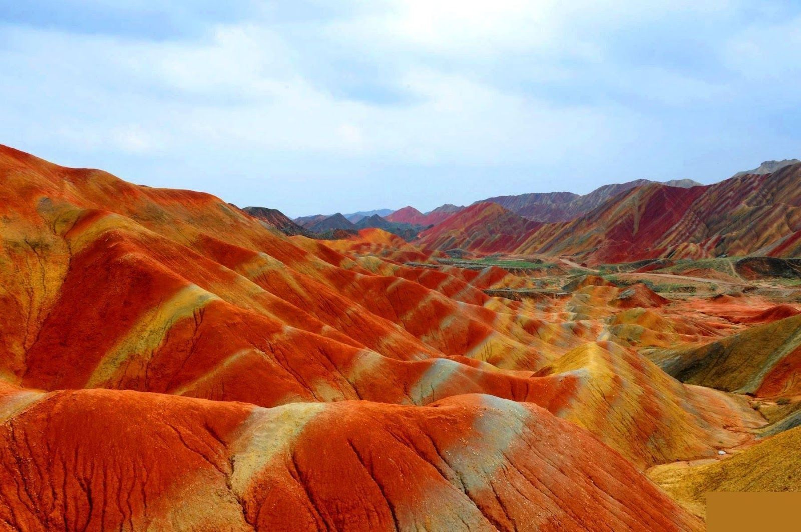
## Description The Zhangye Danxia landform in Gansu province is a riot of color spread across layered sandstone ridges and steep cliffs, creating landscapes that look as if someone painted the earth with broad strokes of red, orange, yellow and green. The chromatic bands are the product of red sandstone and mineral deposits laid down over 24 million years and later uplifted and carved by wind and water. Viewed from purpose-built overlooks and winding boardwalks, the patterns create optical illusions of waves and folds that shift with the sun’s angle. The site is remarkable both for its vivid palette and for the scale of the striations: what from a distance seems like painted canvas resolves into a labyrinth of ridges, gullies and panoramic terraces. A lesser-known detail: the colors vary seasonally and with weather conditions; after rain, the hues often deepen, offering particularly saturated photographic opportunities. Beyond the immediate visual drama, Zhangye Danxia offers a lesson in geologic time and human-scale interpretation of landscape. The park's boardwalks and viewing platforms were designed to give visitors a range of compositions at different elevations, while interpretive signs explain the processes of sedimentation, uplift and erosion that produced the striking bands. Photographers and landscape enthusiasts often plan their visits around atmospheric conditions: low-angle light during golden hours casts ridges into sharp relief, while overcast or misty days can soften colors and emphasize shapes. The park's scale means that a single viewpoint never fully captures the variety present across the terrain — taking time to traverse multiple platforms yields a richer sense of the formations. Local infrastructure has expanded to accommodate steady tourism, but many visitors still find quiet corners along lesser-known paths. For those willing to explore beyond the main viewing decks, short hikes and rural lanes reveal unexpected perspectives of the painted cliffs and provide a quieter atmosphere for contemplative study. The town of Zhangye offers practical amenities including hotels, train connections and guided-tour services; most visitors access the geopark via a short drive from the city. When combined with nearby attractions in Gansu province — historic Silk Road sites, oasis towns and desert landscapes — Zhangye Danxia becomes a vivid and contrasting chapter in any northwest China itinerary. ## Location The Zhangye Danxia Geopark lies in Zhangye city, Gansu province, northwestern China. It’s accessible by road from Zhangye city center, which in turn connects by train or air to larger Chinese hubs such as Lanzhou and Xi’an. The park’s viewing platforms are designed for staged sightseeing, enabling visitors to experience different panoramas without extensive trekking. Timetables for trains and regional buses vary seasonally; many travelers arrive by high-speed or conventional rail to Zhangye and then take local shuttle services or taxis to the geopark entrance. The park's layout is linear, with a series of parking lots and platforms that correspond to different photographic viewpoints — plan logistics to avoid backtracking during peak hours. Accommodation in Zhangye ranges from economical guesthouses to mid-range hotels that can arrange guided excursions and private transport. ## Tips - **Visit at golden hour:** Sunrise or sunset gives the painted ridges warmer tones and dramatic shadows. - **Use multiple viewpoints:** Walk the main boardwalk and visit several overlooks to appreciate how the formations change with perspective. - **Protect from dust and sun:** The region is arid; bring sun protection and a dust cover for camera gear. - **Consider guided photo tours:** Local guides can take you to lesser-known vantage points for unique compositions. - **Time your transport:** Parking and shuttle flows can be busy; arrive early to avoid crowds at the main platforms. - **Dress for desert conditions:** Layered clothing, sturdy shoes and water are essential; evenings can cool significantly. - **Respect park rules:** Stay on boardwalks to protect fragile soils and prevent erosion; drones are often restricted. - **Bring varied lenses:** A wide-angle to capture panoramic ridgelines and a moderate telephoto to isolate patterns will be useful. ## Conclusion Zhangye Danxia offers one of the planet’s most vivid examples of sedimentary color and erosion, a landscape that rewards patient observation and thoughtful composition. Visiting Zhangye Danxia is as much an exercise in perception as it is in travel logistics — the colors and forms change with light, season and vantage point, and the most memorable experiences come when you slow down and let the terrain reveal its subtleties. For photographers, geologists and curious travelers, the geopark is a compelling and photogenic stop that pairs well with broader exploration of Gansu’s cultural and natural history. ## FAQ - **Q: Is the park walkable?** - A: Yes — well-maintained boardwalks and viewing platforms offer accessible scenic routes. - **Q: Can I drive between viewpoints?** - A: Internal park transport and short walks connect main viewpoints; check park maps for distances. - **Q: When is the best season for color saturation?** - A: Late spring through early autumn generally provides strong color contrast, but early morning light and post-rain conditions often produce the most saturated hues. - **Q: Are drones allowed for aerial photography?** - A: Drone policies vary and are often restricted near protected viewpoints — always check park regulations and obtain permits if required. - **Q: How much time should I allocate?** - A: A full half-day can cover the primary platforms; photographers might want a full day to cycle through light conditions and multiple viewpoints. - **Q: What other nearby sites pair well with Zhangye Danxia?** - A: Historic Silk Road towns, the Mati Temple Grottoes and desert landscapes around Zhangye make for complementary cultural and geological explorations. ## Links - [Zhangye Danxia — Wikipedia](https://en.wikipedia.org/wiki/Zhangye_National_Geopark)
GemVoyage Team • World
Berlin
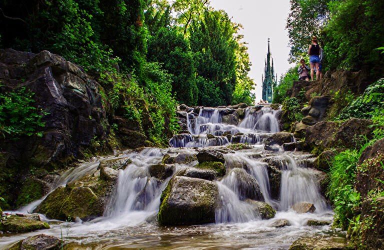
## Description **Viktoriapark** is one of Berlin’s most distinctive urban green spaces, combining **natural elevation, engineered waterfalls, panoramic city views, and national symbolism** within a compact yet dramatic landscape. Unlike Berlin’s vast flat parks such as Tiergarten or Tempelhofer Feld, Viktoriapark stands out because it rises sharply above the surrounding streets, offering one of the **best natural viewpoints in the entire city**. The park is centered around **Kreuzberg Hill**, a 66-meter-high elevation that gives the surrounding district its name. At the summit stands the imposing **National Monument for the Wars of Liberation** (Nationaldenkmal für die Befreiungskriege), a Gothic-style cast-iron monument designed by **Karl Friedrich Schinkel** and completed in 1821. The monument commemorates Prussia’s victory over Napoleon and represents one of the earliest major patriotic memorials in Germany. Its dark, spired form creates a dramatic silhouette against the sky and serves as a visual anchor for the entire park. One of Viktoriapark’s most beloved features is its **artificial waterfall system**, which cascades down the eastern slope of the hill toward Kreuzbergstraße. Built in the late 19th century, the waterfall was designed to mimic alpine mountain streams, bringing the sound, movement, and cooling atmosphere of flowing water into the dense urban fabric. During warm months, these waterfalls become the emotional heart of the park—children play at the base, couples sit on the stone steps, and photographers wait for light to catch the moving water. What makes Viktoriapark particularly compelling is the way it merges **romantic landscape design with political history**. The hill was reshaped during the 19th century to fit the ideals of romantic nationalism, where nature, sacrifice, and monumentality were meant to reinforce each other. The result is a park that feels both organic and highly symbolic at the same time. A little-known fact is that Kreuzberg Hill was once part of a **vine-growing region**, and small-scale wine production existed here in earlier centuries. Even today, a modern vineyard operates on the slope near the monument, producing limited local wine each year. Another lesser-known detail is that the waterfall only runs during the warmer months, meaning many winter visitors never realize that this dramatic feature exists at all. Beyond its historical symbolism, Viktoriapark plays a vital role in everyday neighborhood life. It is a **local refuge** for residents of Kreuzberg, attracting joggers, families, musicians, dog walkers, and sunset watchers. Unlike some of Berlin’s more monumental parks, Viktoriapark maintains a **distinctly neighborhood-driven character**, blending tourism and local daily rhythm without feeling staged. Emotionally, the park shifts moods throughout the day. Mornings are quiet and misty along the lower paths. Afternoons bring activity and movement. Evenings transform the summit into a gathering point for people watching the sun sink behind Berlin’s rooftops. From the top, visitors can often see landmarks such as the **TV Tower (Fernsehturm)** and distant church spires, reinforcing the sense of standing above the city without ever leaving it. ## Location **Viktoriapark** is located in the **Kreuzberg district of central Berlin**, close to the border with Schöneberg. **City:** Berlin **Region:** Berlin (city-state) **Country:** Germany **District:** Kreuzberg (Friedrichshain-Kreuzberg borough) ### How to Get There: * **By U-Bahn:** * **Line U6** to **Platz der Luftbrücke**, then walk about 10 minutes. * **Line U7** to **Mehringdamm**, then walk about 12–15 minutes. * **By bus:** Several bus lines stop along Mehringdamm and Kreuzbergstraße. * **By bicycle:** Well connected by bike lanes and ideal as part of a Kreuzberg cycling route. * **By taxi or ride-hailing apps:** Direct access from anywhere in central Berlin. * **On foot:** Easily reachable from Bergmannkiez and Tempelhofer Damm areas. The park’s elevated position makes it visible from many surrounding streets, acting as a **natural landmark within Kreuzberg**. ## Tips * **Visit near sunset:** The panoramic view from the monument is one of the best free sunset spots in Berlin. * **Check if the waterfall is running:** It is typically active only from spring to autumn. * **Wear comfortable shoes:** The paths include steep inclines and irregular stone steps. * **Bring a light jacket:** Wind at the top can be significantly stronger than street level. * **Combine with Bergmannkiez:** The surrounding neighborhood is full of cafés, bakeries, and local restaurants. * **Avoid peak hours for quiet time:** Late afternoons on weekends can be crowded. * **Respect the monument:** It is a protected historical site, not a climbing structure. * **Photography tip:** Early morning light illuminates the eastern slope and waterfall beautifully. ## Conclusion **Viktoriapark** is a rare Berlin green space where **natural elevation, romantic landscape design, national history, and everyday local life intersect**. From its cascading waterfalls and shaded paths to the solemn monument crowns its summit, the park offers both emotional contrast and visual depth. It is not grand in size, but in **experience, symbolism, and atmosphere**, it ranks among the most memorable outdoor spaces in the city. ## FAQ **1. What is Viktoriapark famous for?** It is best known for its **hilltop national monument, artificial waterfalls, and panoramic city views**. **2. Is Viktoriapark suitable for children?** Yes. Families visit frequently, especially near the lower waterfall areas, though supervision is required due to rocky terrain. **3. Is there an entrance fee?** No. Viktoriapark is **free and open to the public**. **4. Does the waterfall run all year?** No. It usually operates **only during the warmer months**. **5. Can you see major landmarks from Viktoriapark?** Yes. On clear days, you can spot parts of the **Berlin skyline including the TV Tower**. **6. How long should a visit take?** Most visits last **45 minutes to 1.5 hours**, depending on walking pace and time spent at viewpoints. ## Links * [Official Berlin Parks Page](https://www.berlin.de/tourismus/parks-und-gaerten/3560783-1740419-viktoriapark.html)
GemVoyage Team • World
Ottawa
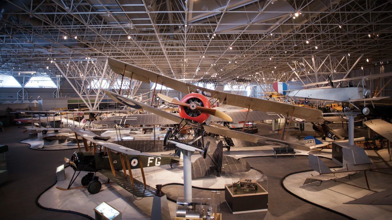
## Description The **Canada Aviation and Space Museum**, located in **Ottawa, Ontario**, is one of the most comprehensive aviation museums in the world and the premier institution of its kind in Canada. It showcases the country’s rich history of flight and space exploration, from the earliest biplanes to cutting-edge spacecraft technology. The museum’s vast collection includes **more than 130 aircraft and artifacts** representing civil, military, and experimental aviation. Visitors can see iconic planes such as the **Avro Arrow**, the **Silver Dart** (Canada’s first powered aircraft), and **Second World War fighters** like the **Spitfire** and **Hurricane**. There’s also an impressive section dedicated to **Canadian contributions to space exploration**, including displays about the **Canadarm**, **satellite technology**, and the role of Canadian astronauts in international missions. What makes the museum unique is its **hands-on, immersive experience**. Guests can climb into the cockpits of select aircraft, take guided tours of the restoration hangars, or even book a **real sightseeing flight** over Ottawa in a vintage **Waco UPF-7 biplane** (available seasonally). Interactive exhibits explain the physics of flight and the engineering challenges behind space travel, making it an engaging experience for visitors of all ages. A lesser-known fact is that the museum sits on the site of a **former Royal Canadian Air Force base**, and its origins date back to **1964**, when the National Aeronautical Collection was established. Another little-known feature is the **Living History program**, where retired pilots and engineers volunteer to share personal stories about the aircraft they flew or maintained — adding a deeply human dimension to the experience. ## Location The **Canada Aviation and Space Museum** is located at **11 Aviation Parkway**, in **Ottawa, Ontario, Canada**. It sits along the **Ottawa River**, just **10 minutes northeast of downtown Ottawa** and close to the **Rockcliffe Airport**. To get there: * **By car:** Take the **Aviation Parkway** from the city center; parking is available on-site for a small fee. * **By public transport:** OC Transpo bus routes connect from downtown Ottawa to stops near the museum (check current schedules before traveling). * **By bike or on foot:** The scenic **Ottawa River Pathway** leads directly to the museum for those enjoying a leisurely ride or walk. The museum’s location offers not only history and technology but also beautiful natural surroundings, making it a great addition to a full day of sightseeing in the capital. ## Tips * **Plan 2–3 hours for your visit:** The collection is large, and the interactive displays deserve time to explore. * **Check for special exhibitions:** The museum frequently hosts temporary displays, from space robotics to women in aviation. * **Book the biplane ride early:** The **Waco biplane experience** is a highlight for many visitors and sells out quickly, especially in summer. * **Visit with children:** The **Kids’ Zone** and interactive simulators make it family-friendly and educational. * **Photography:** Cameras are welcome — you can take stunning shots of aircraft interiors and panoramic hangar views. * **Combine with nearby attractions:** The **Canada Science and Technology Museum** and **Rideau Hall** are nearby for a full day of exploration. * **Visit in winter:** Indoor exhibits make it a great year-round attraction, ideal for cold or rainy days in Ottawa. ## Conclusion The **Canada Aviation and Space Museum** is more than a collection of aircraft — it’s a journey through Canada’s technological spirit, courage, and imagination. From early bush pilots who connected remote regions to astronauts who ventured beyond Earth’s atmosphere, the museum celebrates the nation’s boundless drive to explore. Whether you’re an aviation enthusiast, a history lover, or simply curious about humanity’s quest to fly, this Ottawa landmark offers an inspiring and educational experience that soars above expectations. ## FAQ **1. When was the museum founded?** The museum was established in **1964** as the National Aeronautical Collection and became the **Canada Aviation and Space Museum** in **1982**. **2. What are the museum’s main highlights?** Key attractions include the **Avro Arrow**, **Silver Dart**, **WWII aircraft**, **Canadarm**, and the **space exploration gallery**. **3. Is it suitable for children?** Yes, the museum is very family-friendly, featuring hands-on activities, simulators, and a dedicated **Kids’ Zone**. **4. How long should I spend there?** Most visitors spend **2 to 3 hours**, though aviation enthusiasts may want to stay longer. **5. Is there parking available?** Yes, there is ample on-site parking for a small daily fee. **6. Can I take a real flight?** Yes, visitors can book **sightseeing flights** in a vintage **Waco UPF-7 biplane** during the warmer months. **7. Is it open year-round?** Yes, the museum is open throughout the year, though operating hours may vary seasonally. ## Links * [Ottawa Tourism – Aviation and Space Museum](https://www.ottawatourism.ca)
GemVoyage Team • World

Comments