GemVoyage Team • World
Yinhe Cave (銀河洞), often translated as “Milky Way Cave” or “Galaxy Cave,” is one of northern Taiwan’s most atmospheric hidden landmarks. Tucked deep within lush subtropical forest, this small but visually arresting cave temple blends natural rock formations, cascading waterfalls, and quiet Buddhist spirituality into a single, almost dreamlike destination. Unlike grand mountain temples or vast cave systems, Yinhe Cave owes its appeal to intimacy, mystery, and silence rather than scale.
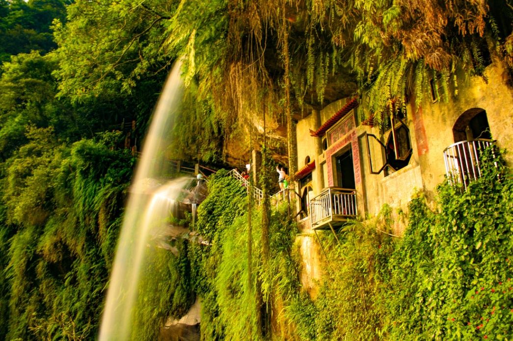
The cave is formed from natural sandstone and has been carved further by flowing water over centuries. A narrow waterfall flows directly through the entrance of the cave, spilling over stone steps and into a shallow pool below. Behind the falling water sits a small Buddhist shrine, turning the cave into a functioning place of worship rather than a simple geological feature. The constant movement of water creates a soft echo through the rock chamber, giving the space a meditative rhythm that visitors often describe as hypnotic.
What makes Yinhe Cave especially unique is the way human devotion and natural erosion intersect. The cave was not aggressively reshaped into a large religious complex; instead, the shrine was carefully adapted to the existing stone cavity. This restraint preserves the raw personality of the site. Moss-covered stairways, dripping rock walls, and filtered green light reinforce the sense that the cave is alive rather than decorative.
The surrounding environment is just as important as the cave itself. The approach trail winds through dense forest, bamboo groves, and small wooden bridges, forming part of a broader hiking network in the hills of New Taipei City. Along the way, visitors pass streams, vines, singing insects, and occasional distant city noise fading into silence. This contrast between urban Taiwan and deep forest isolation happens quickly and dramatically, which enhances the emotional impact of arriving at the cave.
A little-known fact is that Yinhe Cave was historically used as a meditation site by local monks, not as a public tourist attraction. Its popularity grew mainly through hikers and photographers over the last two decades rather than through formal religious promotion. Another lesser-known detail is that the name “Galaxy Cave” does not come from astronomy, but from the way the waterfall scatters light into mist, resembling a flowing star field during early morning sunlight.
Yinhe Cave is not a place for crowds, performances, or commercial stalls. It is a destination of low noise, slow movement, and quiet attention. For travelers seeking spectacle, it may feel understated. But for those seeking atmosphere and emotional texture, it delivers something rare: a sacred space formed more by water and time than by human hands.
Yinhe Cave (銀河洞) is located in the Xindian District (新店區) of New Taipei City, in northern Taiwan, just south of central Taipei.
City: New Taipei City
Region: Northern Taiwan
Country: Taiwan
District: Xindian (新店區)
From the nearest drop-off point, visitors must complete a moderate forest hike, typically 30–45 minutes depending on route and pace.
Yinhe Cave (銀河洞) is a rare blend of natural erosion, flowing water, and quiet religious presence, offering one of northern Taiwan’s most atmospheric micro-destinations. It is not a place for spectacle or quick tourism, but for travelers who seek silence, texture, and emotional contrast. Hidden just beyond the reach of Taipei’s urban sprawl, Yinhe Cave reveals how quickly modern density can dissolve into spiritual isolation when nature is allowed to lead.
1. What is Yinhe Cave famous for?
It is known for its waterfall flowing directly through a cave temple, blending nature and spiritual architecture.
2. Is Yinhe Cave difficult to reach?
Yes. It requires a moderate forest hike after reaching the general area by MRT, bus, or taxi.
3. Is Yinhe Cave suitable for children?
Older children with hiking experience can manage it, but the slippery stairs and uneven terrain make it unsuitable for very young children.
4. Is there an entrance fee?
No. Yinhe Cave is free to enter and open to the public.
5. Can I visit during the rainy season?
Yes, but extra caution is required, as trails and stone steps become extremely slick.
6. How long does the full visit typically take?
Most visitors spend 2 to 3 hours total, including hiking time.
Discover more hidden gems you might love.
Zürich
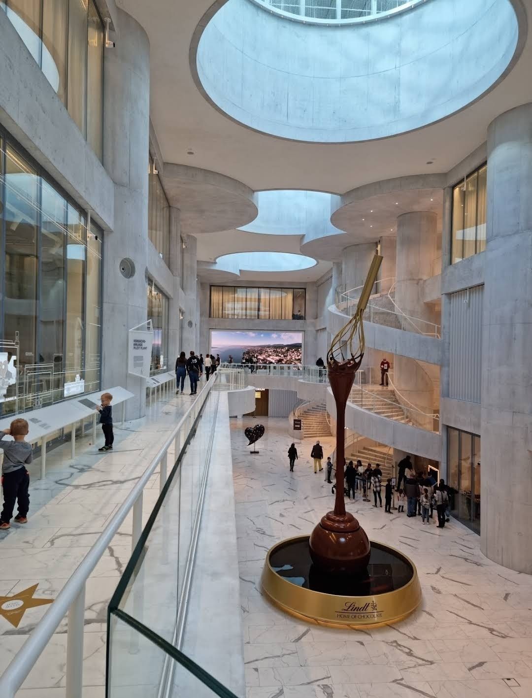
## Description The **Lindt Home of Chocolate** is one of Switzerland’s most delicious attractions, designed to immerse visitors in the fascinating world of Swiss chocolate. Opened in September 2020, this impressive chocolate museum and experience center was created by the Lindt & Sprüngli Foundation and has quickly become a must-visit destination for chocolate lovers worldwide. The highlight of the museum is undoubtedly the **world’s largest free-standing chocolate fountain**, which stands over 9 meters tall and circulates more than 1,000 liters of real liquid chocolate. It’s a breathtaking sight that greets visitors as soon as they enter, setting the stage for a truly mouthwatering experience. Inside, guests can explore interactive exhibitions covering the history of cocoa, the art of chocolate-making, and Lindt’s own story as one of Switzerland’s most beloved brands. Visitors also get to witness master chocolatiers at work in the open kitchen and even create their own chocolate in a hands-on workshop. A lesser-known fact is that the building was designed by the renowned Basel-based architects Christ & Gantenbein, blending modern design with Swiss precision. Another interesting detail is that the museum’s exhibition is available in multiple languages, ensuring that international visitors can enjoy the experience just as much as locals. ## Location The Lindt Home of Chocolate is located in **Kilchberg**, a charming suburb just outside **Zurich, Switzerland**, in the canton of Zurich. The exact address is **Seestrasse 204, 8802 Kilchberg**. Getting there is easy and convenient. From **Zurich’s main train station (Hauptbahnhof)**, visitors can take an S-Bahn train (S1, S8, or S24) to Kilchberg station. From there, it’s just a short walk or a quick bus ride to the museum. Alternatively, a boat ride across Lake Zurich offers a scenic and memorable way to reach Kilchberg. For those traveling by car, parking is available on-site, but spaces can be limited during peak hours. ## Tips To make the most of your visit to the Lindt Home of Chocolate, here are some practical tips: * **Book tickets online in advance** – The attraction is very popular, especially on weekends and holidays, so securing a ticket beforehand is recommended. * **Arrive early** – If you want to enjoy the exhibits and tasting areas with fewer crowds, plan your visit in the morning. * **Don’t miss the chocolate tasting** – The museum includes generous sampling stations where you can taste Lindt’s creations. Come hungry! * **Join a workshop** – For a more interactive experience, sign up for a chocolate-making workshop with Lindt’s master chocolatiers. Spots fill up quickly, so reserve early. * **Visit the shop** – The Lindt store inside is one of the largest chocolate shops in the world, offering exclusive products and unique flavors you won’t find elsewhere. * **Plan about 2–3 hours** – While you can rush through the exhibits in an hour, taking your time allows for a more immersive and enjoyable experience. ## Conclusion The **Lindt Home of Chocolate in Switzerland** is more than just a museum – it’s a celebration of chocolate’s history, culture, and craftsmanship. From the awe-inspiring chocolate fountain to interactive exhibits and hands-on workshops, it’s a dream come true for anyone with a sweet tooth. Conveniently located near Zurich, it’s a must-see destination for travelers looking to indulge in one of Switzerland’s most iconic treasures. ## FAQ **1. How much does it cost to visit the Lindt Home of Chocolate?** Ticket prices vary depending on age and type of visit, but adults can expect to pay around CHF 15–17. Discounts are available for children, students, and groups. **2. How long should I plan for a visit?** Most visitors spend between 2 and 3 hours enjoying the exhibits, workshops, and chocolate tastings. **3. Is the museum family-friendly?** Yes! The Lindt Home of Chocolate is designed for all ages, with interactive displays that both kids and adults can enjoy. **4. Can I buy unique Lindt products there?** Absolutely. The on-site shop is one of the largest Lindt stores worldwide, featuring exclusive products not available elsewhere. **5. Do I need to book in advance?** While walk-ins are possible, booking online in advance is strongly recommended, especially during weekends and holidays. ## Links * [Official Website – Lindt Home of Chocolate](https://www.lindt-home-of-chocolate.com)
GemVoyage Team • World
Tokyo
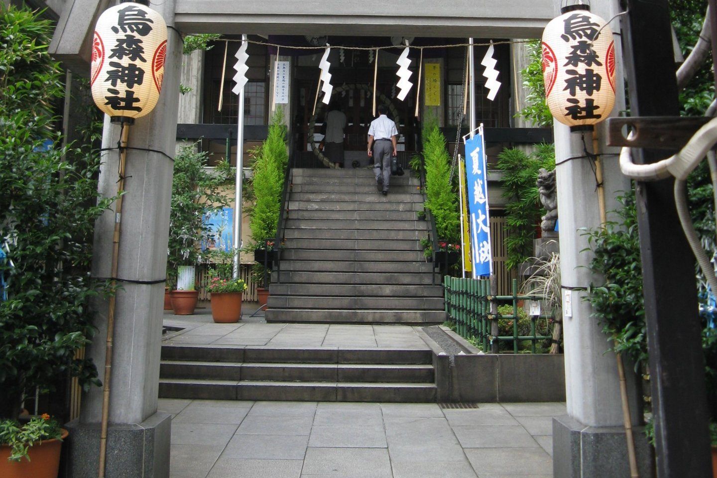
## Description **Karasumori Shrine (烏森神社)** is a small yet deeply symbolic Shinto shrine tucked into one of Tokyo’s most modern and fast-paced districts. Unlike large, monumental shrines surrounded by forests or expansive grounds, Karasumori stands out precisely because of its **contrast with its surroundings**. Encircled by office towers, restaurants, and neon-lit streets near Shimbashi, the shrine feels like a quiet spiritual pocket preserved inside the machinery of the modern city. The shrine is dedicated primarily to **Ame-no-Uzume-no-Mikoto**, a Shinto deity associated with joy, performance, and the arts, as well as protection from misfortune. Because of this, Karasumori Shrine has long been popular with **actors, entertainers, businesspeople, and office workers**, all of whom come to pray for success, smooth communication, and good fortune in their professional lives. What truly makes Karasumori Shrine unique is its **distinctive omamori (protective charms)**. These charms are unusually colorful, often featuring bright red, yellow, blue, and green threads rather than the subdued tones found at most shrines. According to shrine tradition, these colors represent protection from misfortune arriving from any direction. This detail is relatively unknown outside Japan and has helped the shrine develop a quiet but loyal following among locals. Another lesser-known fact is that Karasumori Shrine was originally located closer to Edo Castle but was moved to its current position during urban development. Despite its relocation, it retained strong ties to merchants and workers, which explains its enduring relevance in a business district rather than a residential or historical one. The shrine has also survived fires, earthquakes, and wartime destruction, making it a subtle symbol of resilience amid Tokyo’s constant transformation. Karasumori Shrine is not a place for grand ceremonies or long visits. Its value lies in **intimacy, symbolism, and continuity**, offering a moment of pause rather than spectacle. ## Location **Country:** Japan **Region:** Kantō **City:** Tokyo **Ward:** Minato **Area:** Shimbashi Karasumori Shrine is located just a short distance from Shimbashi Station, one of Tokyo’s major transportation hubs and a center for office culture and nightlife. ### How to Get There * **By train:** * JR Yamanote Line, Keihin-Tohoku Line, or Tokyo Metro Ginza Line to **Shimbashi Station**. From the Karasumori Exit, the shrine is a 2–3 minute walk. * **By subway:** * Toei Asakusa Line to Shimbashi Station, also within walking distance. * **On foot:** * Easily accessible if you are exploring central Tokyo districts such as Ginza or Shiodome. * **By taxi:** * A convenient option due to the shrine’s central location, though unnecessary given public transport access. ## Tips * **Visit during weekdays for atmosphere:** You will see office workers stopping by during lunch breaks or after work. * **Be respectful of space:** The shrine grounds are compact, and local worshippers come for quiet prayer. * **Purchase an omamori:** The colorful charms are the shrine’s most distinctive feature and make meaningful souvenirs. * **Avoid peak commute times:** Early morning and early evening can be crowded due to nearby train traffic. * **Short visit is sufficient:** 15–30 minutes is enough to appreciate the shrine fully. * **Photography is allowed, but discreet:** Avoid photographing people while they are praying. ## Conclusion Karasumori Shrine offers a rare glimpse into Tokyo’s spiritual life as it exists today, not as a preserved relic but as a living part of the urban routine. Small, understated, and symbolic, it rewards visitors who value authenticity and subtlety over grandeur. ## FAQ **1. Is Karasumori Shrine famous?** It is well-known among locals but relatively unknown to international tourists. **2. Is there an entrance fee?** No, entry is free. **3. How long should I spend there?** Around **15 to 30 minutes** is sufficient. **4. What is the shrine best known for?** Its colorful protective charms and prayers for career success and good fortune. **5. Is it suitable for first-time visitors to a Shinto shrine?** Yes, its small size makes it approachable and easy to understand. **6. Can I combine it with other attractions?** Yes, it pairs well with visits to Ginza, Shiodome, or nearby dining areas. ## Links * [Japan National Tourism Organization](https://www.japan.travel)
GemVoyage Team • World
Nida
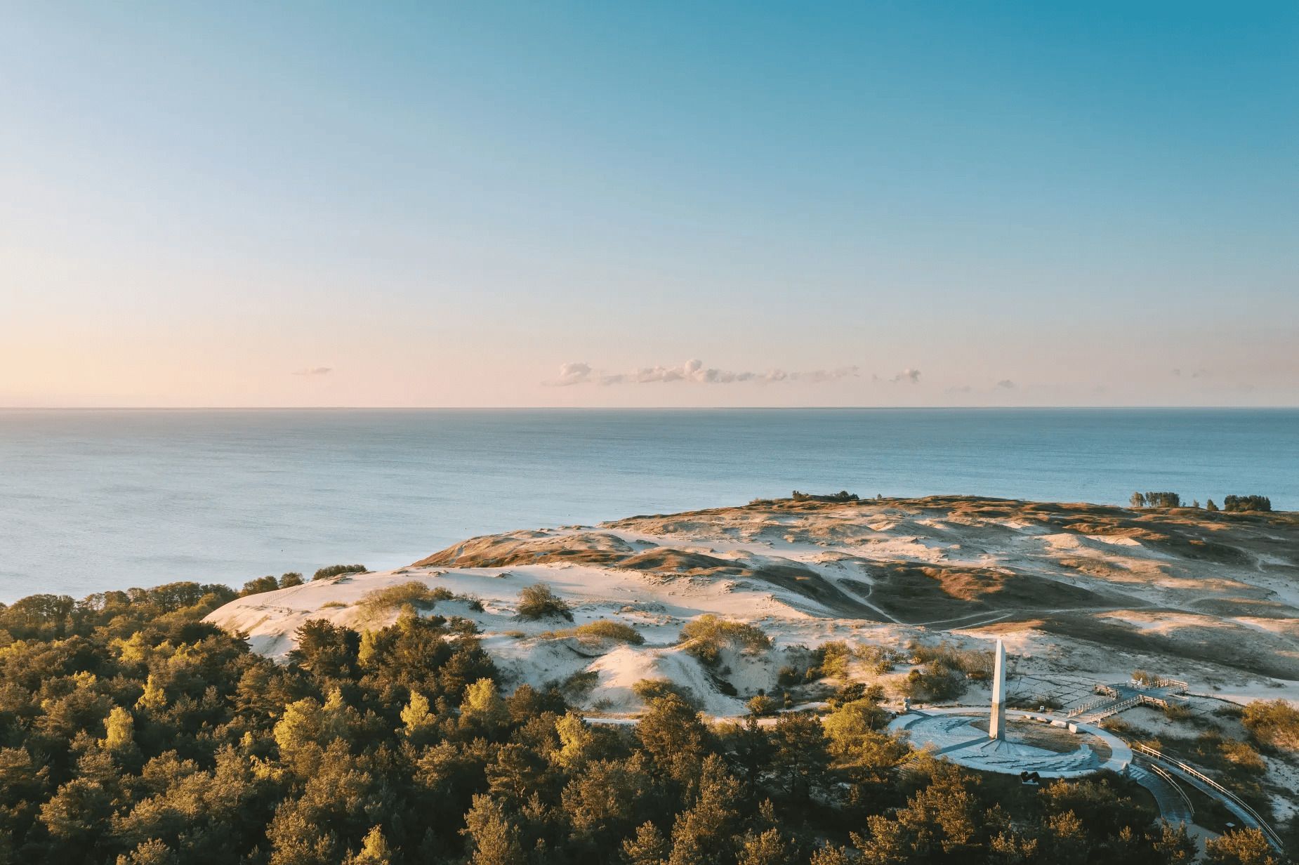
## Description The Parnidis Dune sundial on the Curonian Spit is an elegant meeting point of coastal geology and human curiosity. Carved into a prominent dune ridge near Nida, the sundial uses a simple stone gnomon and stone markers to register the sun’s arc across the sky, while the dune itself provides sweeping views over the Curonian Lagoon and the Baltic Sea. The combination of sculpted sand, long sightlines, and the shifting play of light makes the site both visually stirring and quietly contemplative. Visitors encounter an open landscape shaped by wind and water: dunes that migrate slowly with prevailing winds, vegetation adapted to sandy, saline conditions, and an expansive horizon where sky and water blend. The sundial is part functional instrument, part landscape sculpture: its hour lines and markers are calibrated to local solar time and offer an accessible way to experience astronomical motion at ground level. Restoration and maintenance are ongoing challenges because the dune is dynamic—sand moves, vegetation changes, and repairs must respect both the scientific accuracy of the instrument and the dune’s natural processes. Local authorities and conservation groups work to stabilize key paths and protect fragile slopes so that people can enjoy the views without accelerating erosion. Cultural events and astronomy programs often use the site as a natural amphitheater, further connecting visitors with the seasonal rhythms of sky and sea. ## Location Parnidis Dune is located in Nida on the Curonian Spit, within Neringa municipality in Klaipėda County on Lithuania’s western coast. The dune crowns a ridge that overlooks the Curonian Lagoon on one side and the Baltic Sea on the other, giving it dramatic vantage points in both directions. How to get there: Nida is accessible by car along the Curonian Spit road from Klaipėda; if approaching from mainland Lithuania, a ferry crossing into the spit may be necessary depending on route. Regular buses also run from Klaipėda to Nida during the tourist season. Once in Nida, the Parnidis Dune is a short, well-signed walk from the town center; follow the marked paths to the main observation points and sundial. ## Tips - Visit at sunrise or sunset for the most dramatic light and to see the sundial’s shadows lengthen. - Stay on marked trails and access ramps—dune vegetation is fragile and paths help prevent runaway erosion. - Bring windproof layers and sun protection; the exposed ridge can be quite breezy even on mild days. - Use binoculars or a telephoto lens to scan the lagoon for birds, fishing boats, and shifting sandbars. - Combine a dune visit with a walk through Nida’s quaint center and nearby cultural sites, such as the Thomas Mann museum. - Check local signage for any temporary closures or restoration work; some sections may be rerouted to protect the landscape. ## Conclusion Parnidis Dune’s sundial offers more than a neat photo opportunity: it is an invitation to feel how landscape, time, and human craft can intersect. The ridge’s panoramic views, paired with the simple mechanics of the sundial, make the place an evocative stop for anyone exploring the Curonian Spit. ## FAQ Q: Is there an admission fee to access the dune? A: There is typically no admission fee to reach Parnidis Dune itself; however, parking or guided services may charge fees. Seasonal event programming may require tickets. Q: When is the best time to photograph the sundial and landscape? A: Sunrise and sunset provide warm, low-angle light that accentuates dune textures and long shadows; golden hour is ideal for landscape photography. Q: Can I climb anywhere on the dune? A: No. To protect dune vegetation and prevent erosion, visitors should use the marked trails and observation points only; climbing fragile slopes is discouraged or prohibited. Q: Are there guided tours or astronomy events at the site? A: Yes. Local guides and cultural groups sometimes offer tours that explain the sundial’s construction and the dune’s ecology; astronomy and cultural events are occasionally scheduled—check Nida’s visitor information. Q: Is the area accessible for visitors with limited mobility? A: Some paths and viewpoints may have improved access, but the dune’s terrain is inherently uneven. Check local visitor resources for the latest information on accessible routes. ## Links - [Parnidis Dune (Wikipedia)](https://en.wikipedia.org/wiki/Parnidis_Dune)
GemVoyage Team • World
Tokyo
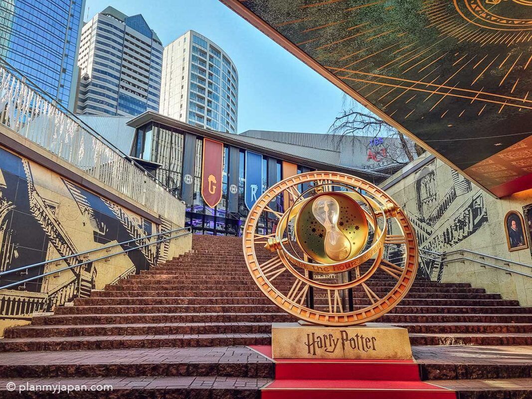
## Description The **Harry Potter Stairs & Time Turner (ハリー・ポッター階段とタイムターナー)** in Tokyo is one of the city’s most popular **pop-culture photo landmarks**, blending cinematic fantasy with modern urban design. This attraction is not a historical monument or a traditional museum—it is a **themed visual installation inspired by the Harry Potter film series**, designed specifically for fans who want to step inside the wizarding world without leaving central Tokyo. The installation recreates two of the most iconic visual elements from the films: the **magical moving staircase of Hogwarts** and **Hermione Granger’s Time Turner** from *Harry Potter and the Prisoner of Azkaban*. The staircase evokes the illusion of shifting directions and hidden passages, while the oversized Time Turner sculpture serves as a symbolic centerpiece representing time travel, destiny, and choice—core themes in the Potter universe. What makes this location truly unique is that it exists **inside a contemporary commercial complex rather than a theme park**. This means visitors do not need to buy expensive tickets or travel to a resort location to enjoy an immersive Harry Potter-themed environment. The installation uses **cinematic lighting, reflective metallic surfaces, stone textures, and enchanted-style typography** to create a convincing atmosphere of fantasy within a very modern architectural setting. The stairs are often used as a **staged photo zone**, where visitors recreate scenes, cosplay as characters, or simulate stepping into a time-loop narrative. The Time Turner sculpture is particularly photogenic when illuminated in the evening, when its rotating rings and glowing accents transform the space into a dramatic visual set piece. Many visitors describe the experience as feeling like walking into a **film trailer set inside a shopping mall**—brief, stylized, and designed for visual impact rather than storytelling depth. A little-known fact is that the stairs and Time Turner installation were part of a **long-term promotional collaboration connected to Warner Bros. Japan and official Harry Potter licensing projects**, timed to coincide with renewed franchise activity in Tokyo. Another lesser-known detail is that the space is frequently **updated with seasonal lighting themes and limited-time character visuals**, which means repeat visits can feel subtly different across the year. Importantly, this site is not meant to replace **The Making of Harry Potter Studio Tour Tokyo**; rather, it acts as a **public teaser-style landmark**, accessible to anyone passing through the district. It attracts an extremely diverse crowd: international tourists, Japanese fans, casual shoppers, cosplayers, couples, and social-media creators all intersect in the same space. The emotional appeal of the installation lies in its ability to deliver **instant recognition and nostalgia**. Even a short visit—often no more than 10 to 15 minutes—can trigger powerful emotional connections for fans who grew up with the books and films. It is, at its core, not a storytelling space but a **symbolic photo experience**, built for visual memory rather than narrative immersion. ## Location The **Harry Potter Stairs & Time Turner** installation is located in **central Tokyo**, inside a major commercial complex in the **Akasaka / Roppongi area**, which has become a hub for large-scale themed entertainment projects. **City:** Tokyo **Region:** Kantō **Country:** Japan **District:** Minato Ward (Akasaka / Roppongi area) ### How to Get There: * **By Tokyo Metro:** * **Chiyoda Line** to **Akasaka Station** * **Hibiya Line or Toei Oedo Line** to **Roppongi Station** * **By JR Train:** Use JR lines to nearby hubs such as **Shinjuku or Tokyo Station**, then transfer to the metro. * **By taxi:** Easy and accurate if you show the Japanese attraction name. * **On foot:** The area is highly walkable and well-connected through underground passages and plazas. The installation is typically integrated into a **shopping, dining, and entertainment complex**, making it easy to combine with cafés, retail stores, and evening nightlife. ## Tips * **Visit in the evening:** The lighting effects are significantly more dramatic after sunset. * **Go on weekdays for clearer photos:** Weekends often bring long lines of people waiting for their turn. * **Bring a small tripod if allowed:** For steady night photos, especially around the Time Turner. * **Do not expect a full “attraction experience”:** This is a **visual installation**, not a ride or museum. * **Cosplay is common:** Light cosplay is generally accepted and often encouraged by visitors. * **Respect queue etiquette:** Japanese photo spots usually operate with informal but strict order. * **Combine with nearby Harry Potter experiences:** If you are a serious fan, this pairs well with the Studio Tour Tokyo. * **Check for seasonal updates:** Lighting schemes and banners occasionally change. ## Conclusion The **Harry Potter Stairs & Time Turner in Tokyo** is a compact yet powerful example of how modern cities translate cinematic fantasy into everyday urban space. It is not a destination for long exploration, but a **precise, visually engineered moment of nostalgia**, crafted for fans who want a tangible connection to the wizarding world without committing an entire day to a theme park. For Harry Potter enthusiasts, it delivers something precise and valuable: **a magical pause inside the rhythm of real city life**. ## FAQ **1. Is the Harry Potter Stairs & Time Turner a real theme park attraction?** No. It is a **public visual installation**, not a ride or ticketed experience. **2. Is it free to visit?** Yes. Access is **free**, as it is located inside a public commercial complex. **3. How long does a visit typically take?** Most visitors spend **10 to 20 minutes**, depending on photo queues. **4. Is it suitable for children?** Yes. It is **family-friendly**, though it can get crowded. **5. Is this the same as the Harry Potter Studio Tour Tokyo?** No. This is a **small themed photo landmark**, whereas the studio tour is a full museum-style experience. **6. Can I take professional photos there?** Casual photography is allowed. **Commercial shoots may require permission** from the property management. ## Links * [Warner Bros. Japan](https://www.warnerbros.co.jp) * [Harry Potter Studio Tour Tokyo](https://www.wbstudiotour.jp)
GemVoyage Team • World
Sedgefield
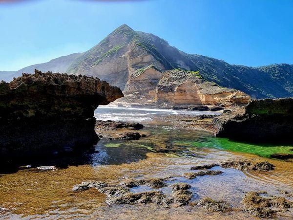
## Description **Gericke’s Point** is one of the hidden gems of South Africa’s Garden Route. Famous for its striking sandstone cliff that resembles the profile of a lion’s head, this natural landmark offers both geological beauty and incredible biodiversity. At low tide, the area transforms into a natural aquarium, revealing tidal pools brimming with colorful marine life such as starfish, sea anemones, and small fish. The rock formation itself is over 150 million years old, part of the ancient Table Mountain sandstone system. Its unusual shape and size make it one of the most photogenic spots along the coast. Beyond its geology, Gericke’s Point is also a birdwatcher’s paradise, with seabirds often seen diving for fish and dolphins occasionally passing offshore. A little-known fact is that the tidal pools here are considered some of the most diverse along the Garden Route, making it a favorite spot for marine biologists and nature enthusiasts. Another fascinating detail is that the rock face has long been a landmark for sailors navigating the coast between Sedgefield and Wilderness. ## Location Gericke’s Point is located near **Sedgefield**, a small town along the **Garden Route** in the **Western Cape Province** of **South Africa**. It lies about 25 kilometers from Knysna and around 40 kilometers from George. To reach the point, visitors typically start at Swartvlei Beach near Sedgefield. From there, a scenic beach walk of about 2–3 kilometers leads to the rock formation. The best time to go is at low tide, when the tidal pools are accessible and the walk is safe. Travelers driving the Garden Route can easily stop at Sedgefield, with parking available near the beach entrance. ## Tips * **Check the tide tables:** Low tide is the only safe and rewarding time to visit. High tide can make the walk dangerous. * **Wear sturdy shoes:** Although the walk is along the beach, exploring the tidal pools requires footwear with good grip. * **Bring a camera:** The lion-shaped rock formation and vibrant tidal pools make for excellent photography opportunities. * **Pack water and sun protection:** There are no facilities along the beach walk, so carry essentials with you. * **Respect marine life:** Avoid disturbing or removing creatures from the tidal pools—this is a fragile ecosystem. * **Stay for sunset:** The area is particularly stunning in the golden light of late afternoon, with the rock formation silhouetted against the ocean. ## Conclusion Gericke’s Point is more than just a rock formation—it is a window into South Africa’s geological past and a living showcase of coastal biodiversity. With its tidal pools, dramatic cliffs, and sweeping ocean views, it offers a perfect mix of adventure and tranquility along the Garden Route. For travelers seeking a memorable nature experience off the beaten path, Gericke’s Point is not to be missed. ## FAQ **1. How long is the walk to Gericke’s Point?** The walk from Swartvlei Beach to Gericke’s Point takes about 30–40 minutes each way, depending on pace and tide conditions. **2. Is it safe to swim near Gericke’s Point?** Swimming is possible in some tidal pools, but the open ocean can be rough. Always exercise caution and avoid strong currents. **3. Can children visit the point?** Yes, children often enjoy exploring the tidal pools, but they should be supervised closely due to slippery rocks and the incoming tide. **4. Is there an entrance fee?** No, Gericke’s Point is free to access, though parking at Swartvlei Beach may sometimes require a small fee. **5. What wildlife might I see?** In addition to tidal pool creatures, visitors may spot dolphins offshore, oystercatchers, and other seabirds. In whale season (June–November), southern right whales are sometimes visible. **6. When is the best time to visit?** The best time is at low tide and preferably in the morning or late afternoon when temperatures are milder and light conditions are ideal. ## Links * [Visit Garden Route – Sedgefield](https://www.visitgardenrouteandkleinkaroo.com) * [South African Tourism – Garden Route](https://www.southafrica.net)
GemVoyage Team • World
Rome
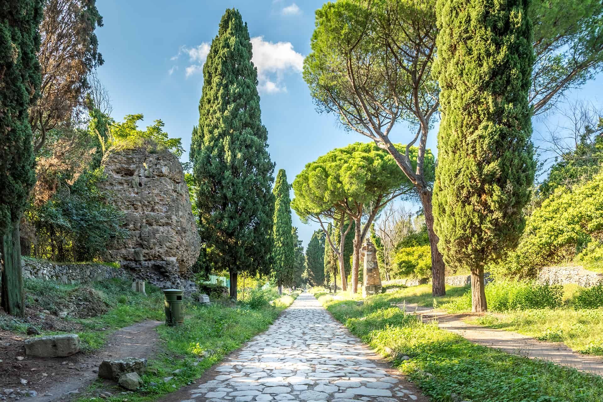
## Description The Appian Way (Via Appia Antica) is one of the most evocative ancient roads in Europe, running southeast from Rome and threading tombs, ruins, and the remains of Roman infrastructure through a pastoral corridor. Lined with funerary monuments and early Christian catacombs, sections of the route preserve original Roman paving and milestones that offer a tangible link to antiquity. Walking, cycling, or riding portions of the Appian Way reveals layers of history: imperial-era tombs, remains of villas, and quieter stretches where the path feels remarkably rural despite being inside Rome's larger urban boundary. Beyond the monuments, the Appian Way is also a public park and archaeological corridor, with protected areas that encourage slow exploration. Many travelers prefer to rent bicycles to cover more ground, though walking smaller stretches provides time to read inscriptions, visit specific catacombs, and take photographs without hurrying. Search-relevant phrases to plan a visit include "Appian Way Rome bike rental", "Via Appia Antica catacombs", and "walk the Appian Way"—terms that match travel guides and visitor resources. ## Location Via Appia Antica begins near the Aurelian Walls and continues southeast into the Roman countryside. Key visitor access points include the Appian Way Park Visitor Center and the areas near the Baths of Caracalla. Public transit options include buses that stop near the main entrances; taxis and bike rentals from central Rome are also common. Parts of the road become parkland with restricted car access, which makes cycling and walking safer and more pleasant. ## Tips - Rent a bike to see more of the route in a single visit: many rental shops offer city pickups and drop-offs near the park. - Visit catacombs with a guide: guided tours provide historical context and access to sites that close early or require reservations. - Wear durable shoes: while paved in places, many stretches have uneven ancient stones—sturdy footwear prevents slips and makes exploration easier. - Start early to avoid midday heat and to capture softer morning light for photography. - Bring water and snacks: services are limited along some stretches, so pack essentials for longer rides or walks. - Respect preservation rules: follow designated paths and do not remove artifacts or disturb archaeological features. ## Conclusion The Appian Way is a living museum and countryside escape rolled into one: accessible, atmospheric, and rich with Roman history. Whether you're cycling past tombs or pausing in a quiet olive grove, the route offers a memorable way to connect with ancient Rome's infrastructure and the everyday topography that shaped imperial travel. ## FAQ Q: How long is the Appian Way and how much can I cover in a day? A: The historic Appian Way stretches for many kilometers; most visitors focus on a 10–20 km segment near Rome that can be walked or cycled in a half-day to full-day depending on pace. Q: Are bicycles available for rent near the Appian Way? A: Yes—bike rental shops and guided bike tours operate from central Rome and near the park entrances. Q: Can I visit catacombs along the Appian Way without a guide? A: Some catacombs permit independent visits, but many recommend or require guided entry to provide context and control visitor numbers—check schedules in advance. Q: Is the Appian Way accessible year-round? A: Generally yes, though some sites and visitor centers follow seasonal hours; winter weather can be cooler and quieter, while spring and fall are popular. Q: Are there food and restroom facilities along the route? A: Basic facilities are available near major access points and visitor centers, but services are sparse in remote stretches—plan accordingly. ## Links - [Appian Way (Wikipedia)](https://en.wikipedia.org/wiki/Appian_Way)
GemVoyage Team • World

Comments