GemVoyage Team • World
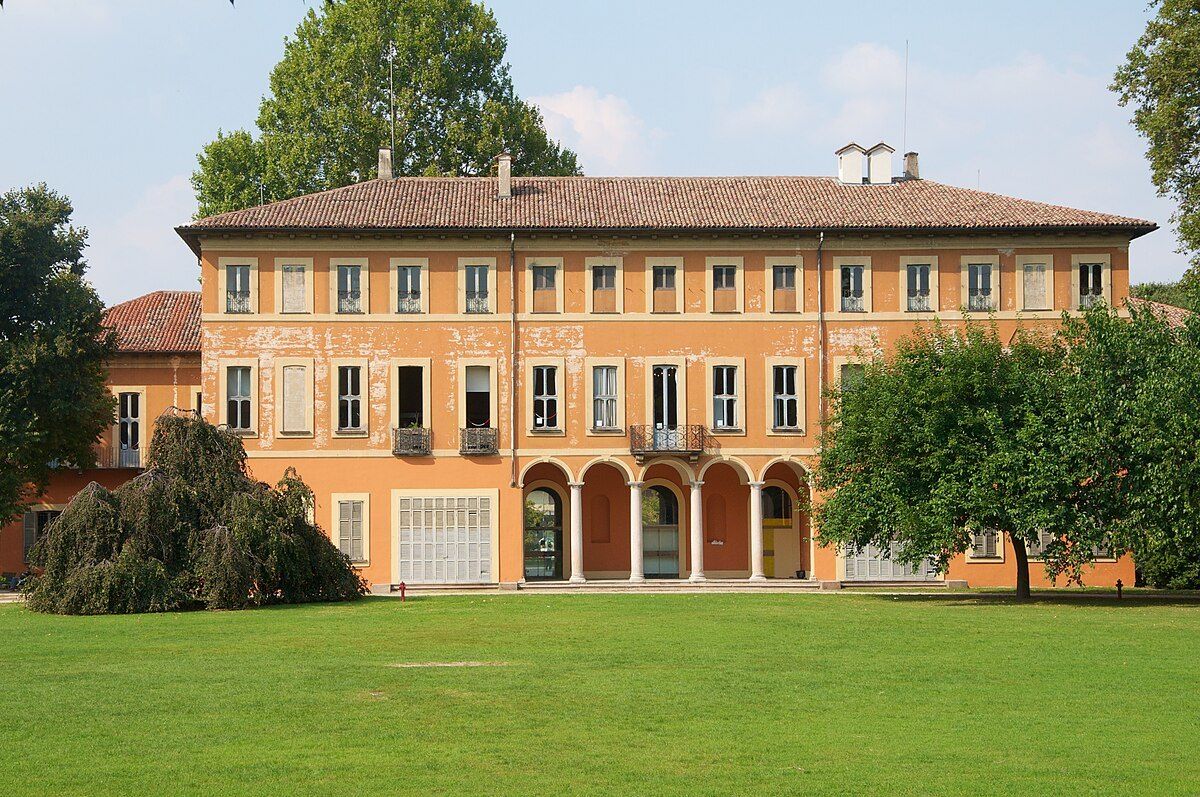
Villa Litta Modignani is one of Milan’s most elegant yet underrated historical residences, offering visitors a quiet immersion into aristocratic life from the 18th and 19th centuries. Built in the late 1700s and later expanded, the villa is a refined example of Neoclassical architecture, characterized by symmetry, restrained decoration, and a strong relationship between the building and its surrounding park. Unlike Milan’s more famous palaces, Villa Litta Modignani retains a residential, almost intimate character that makes it especially appealing to visitors seeking authenticity rather than spectacle.
Originally commissioned by the Modignani family and later acquired by the noble Litta family, the villa became an important cultural and social hub. Over time, it hosted intellectual gatherings, musical performances, and political discussions during periods of significant transformation in Lombardy. Today, the villa functions as a public cultural space, housing municipal offices, exhibition rooms, and community events while preserving its historical interiors and landscaped grounds.
One little-known fact is that Villa Litta Modignani once formed part of a much larger rural estate, surrounded by farmland before Milan’s rapid urban expansion absorbed the area. Another lesser-known detail is that the villa’s interiors still preserve original decorative elements, including frescoed ceilings and period stuccoes, which are often overlooked by casual visitors focused only on the exterior.
The surrounding Parco di Villa Litta enhances the experience significantly. The park combines formal garden layouts with more natural green spaces, making it a popular retreat for locals. The contrast between the villa’s refined architecture and the everyday life unfolding in the park gives the site a living, contemporary relevance that many historic buildings lack.
Country: Italy
Region: Lombardy
City: Milan
District: Affori
Villa Litta Modignani is located in northern Milan, within the Affori district, an area that blends historic residential neighborhoods with modern urban life.
* Take Metro Line M3 (Yellow Line) to Affori FN station. From there, the villa is about a 10-minute walk.
* Regional trains stopping at Milano Affori provide convenient access from other parts of Lombardy.
* Several local lines serve the Affori area and stop near the park entrance.
* Accessible via Milan’s northern ring roads, though street parking may be limited during peak hours.
Villa Litta Modignani is a refined and quietly impressive landmark that reveals a more residential and human-scale side of Milan’s history. Its Neoclassical elegance, layered aristocratic past, and integration into everyday urban life make it an ideal destination for visitors looking beyond the city’s most famous attractions.
1. When was Villa Litta Modignani built?
The villa dates back to the late 18th century, with later expansions in the 19th century.
2. Is the villa open to the public?
Yes, though access to interior spaces may depend on events or exhibitions taking place.
3. Is there an entrance fee?
Access to the park is generally free; exhibitions inside the villa may require a ticket.
4. How long should I plan for a visit?
About 1–2 hours, including time in the park and any exhibitions.
5. Is the villa suitable for children?
Yes, especially the park, which is popular with families.
6. What is the best time to visit?
Spring and early autumn offer the most pleasant weather and greenery.
Discover more hidden gems you might love.
Siberia
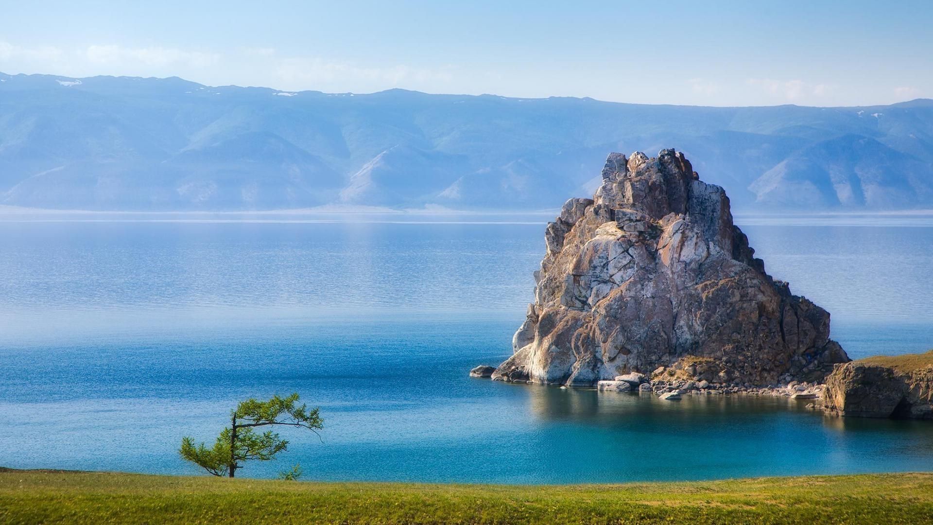
## Description Lake Baikal in southern Siberia is a global natural wonder: the world’s deepest and one of its oldest freshwater lakes, it holds roughly 20% of the planet’s unfrozen surface freshwater by volume. Stretching over 600 kilometers north-to-south and reaching depths of more than 1,600 meters, Baikal’s sheer scale is awe-inspiring. The lake’s crystalline waters, dramatic rifts, and seasonal extremes produce striking phenomena — from the unbelievable clarity of summer waters to the otherworldly expanses of transparent winter ice that allow you to walk, drive, or even ice-sail across a dazzling frozen surface. Baikal is also a hotspot of biodiversity and scientific interest. Its shoreline, submerged terraces, and deep basins host numerous endemic species found nowhere else on Earth, including the Baikal seal (nerpa) — the only seal species that has adapted to a fully freshwater environment — and dozens of endemic fish and invertebrates. The lake’s unique ecology is the result of millions of years of relative isolation, stable cold temperatures at depth, and complex nutrient cycling. Scientists study Baikal to better understand limnological processes, long-term climate records trapped in sediment layers, and the evolution of isolated ecosystems. For travelers, Baikal delivers a rare combination of dramatic landscapes and varied activities across seasons. In summer, the shoreline blooms with wildflowers, and mountain hikes and multi-day treks through taiga and steppe reveal panoramic views over the water. Kayaking, boat excursions, and shoreline camping let you sample the lake’s nearshore biodiversity and peaceful beaches. In winter, when the lake freezes, the surface becomes a vast frozen highway: locals and guides lead safe ice-walking excursions, cross-lake snowmobile trips, ice-fishing experiences, and festivals that celebrate the season. Photographers prize Baikal for its vivid ice formations, clear reflections, and light at dawn and dusk. Beyond natural spectacle, Baikal is threaded with human stories: small lakeside towns such as Listvyanka, the ferry-served Olkhon Island with its shamanic sites, and the city of Irkutsk — a historical gateway with Siberian wooden architecture and museums — are rich portals into local culture. Sustainable and low-impact travel is increasingly available via small-scale guesthouses, ecotour operators, and community-led tours that prioritize the lake’s protection. ## Location Lake Baikal spans the regions of Irkutsk Oblast and the Republic of Buryatia in Russia, with the lake forming a striking spine across southeastern Siberia. The city of Irkutsk is the primary gateway for international and domestic visitors, linked by the Trans-Siberian Railway and regional flights; it offers accommodations, museums, and transport connections. From Irkutsk, paved roads and seasonal bus services reach lakeside settlements like Listvyanka, Port Baikal, and the ferry terminals for Olkhon Island — the lake’s largest island and a cultural heartland with cliffs, shamanic sites, and small villages. Other access points include Ulan-Ude to the east and smaller regional airfields that connect via charter or seasonal flights. Travel times can be long, so many visitors plan multi-day itineraries that combine transit into the lake area with on-site exploration. ## Tips - **Respect seasonal access and local rules:** Ice travel and remote trails require local knowledge; always consult local guides and authorities before venturing onto the ice or into isolated areas. Safety equipment and up-to-date conditions are essential. - **Plan time for Olkhon Island:** Olkhon is a cultural and scenic highlight, with dramatic cliffs, shamanic sites, and small settlements. Allow several days to explore its coves, beaches, and sacred capes. - **Pack for extremes:** Even in summer, weather can shift quickly; bring layered clothing, waterproof shells, sturdy boots, sun protection, and insect repellent. In winter, prioritize thermal layers, insulated boots, and a reliable outer layer. - **Travel with experienced local guides:** Guides provide safety on ice crossings, access to lesser-known shorelines, wildlife-spotting skills, and cultural context about Buryat and Siberian heritage. Choose operators that practice sustainable tourism. - **Respect conservation rules:** Stick to marked paths, avoid disturbing nesting birds or haul-out sites, and follow Leave No Trace principles. Support local conservation initiatives when possible. - **Time your visit for activities:** Summer is best for hiking and kayaking; late spring and early autumn deliver fewer crowds and pleasant light; winter offers unique ice experiences but requires more planning. ## Conclusion Lake Baikal is both a living laboratory and a vast natural wonder: its depth, clarity, and ancient lineage make it one of Earth’s most singular freshwater realms. Whether you come for scientific curiosity, wilderness hiking, cultural exchange with lakeside communities, or simply to witness impossibly clear water and glass-like ice, Baikal rewards patient travel and respectful exploration. Plan carefully, choose sustainable operators, and allow enough time to move slowly around its bays and islands — the lake’s scale is best absorbed at human pace. ## FAQ - **Q: Can you swim in Lake Baikal?** A: Swimming is possible in summer at sheltered beaches and near lakeside villages, but the water remains cold even in peak months; stay near lifeguarded or popular swimming areas, enter gradually to avoid shock, and follow local safety guidance. - **Q: What is the best time to visit Lake Baikal?** A: Late June through September gives the warmest weather, flowering meadows, and easier trekking. Late winter (February–March) is ideal for ice-scenery photography and safe ice excursions when the ice is thickest and the light is crisp. Shoulder seasons offer quieter conditions. - **Q: How do I reach Olkhon Island, and do I need a vehicle?** A: Olkhon is reached via a seasonal ferry or ice road depending on the time of year. Many visitors rent 4x4 vehicles or join guided tours; public buses operate from nearby towns but capacity is limited. Plan logistics in advance, especially in peak season. - **Q: Are there wildlife viewing opportunities?** A: Yes—local guides can help you spot endemic fish species, waterbirds, and in protected offshore areas you may observe Baikal seals. Respect distance guidelines and avoid disturbing habitats. - **Q: Do I need special permits or visas to visit?** A: International visitors need a valid Russian visa. Some protected areas require entry fees or permits for camping and research; check with regional park authorities for up-to-date rules. - **Q: Is Internet and phone coverage available?** A: Coverage varies—cities like Irkutsk and larger settlements have decent mobile data; more remote shorelines and parts of Olkhon have limited connectivity. Prepare for periods offline and download maps or emergency contacts beforehand. ## Links -- [Lake Baikal — Wikipedia](https://en.wikipedia.org/wiki/Lake_Baikal)
GemVoyage Team • World
Cairo
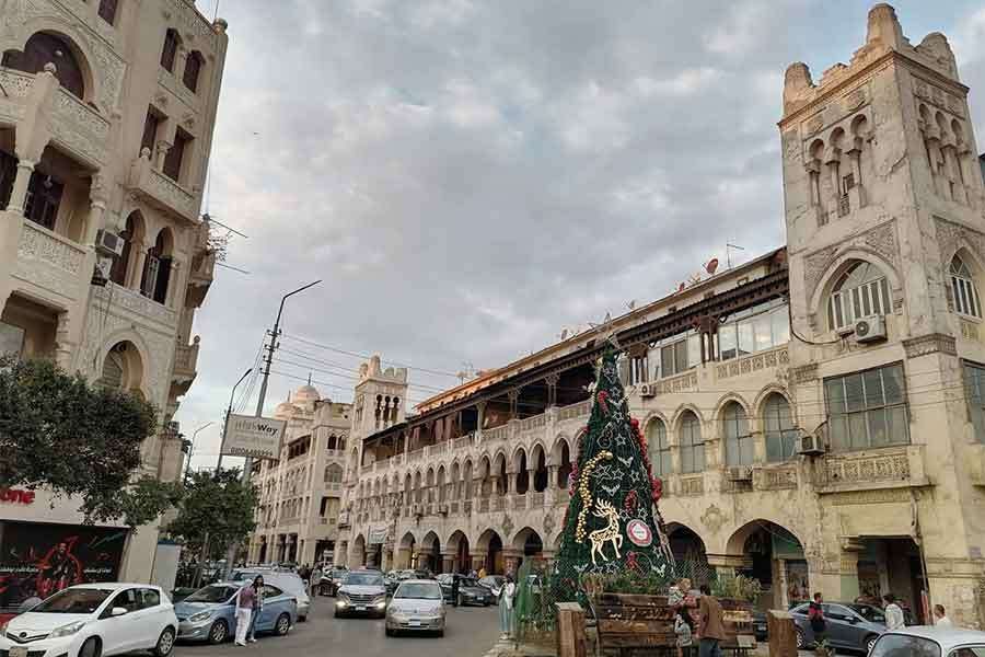
## Description **El Korba Square**, located in the historic district of **Heliopolis (Masr El Gedida)**, is one of Cairo’s most architecturally distinctive and socially vibrant urban spaces. Unlike the medieval fabric of Islamic Cairo or the colonial density of Downtown, El Korba represents a **unique fusion of European town planning, Moorish revival architecture, and early 20th-century cosmopolitan lifestyle**. It is widely regarded as the **ceremonial heart of Heliopolis**, a neighborhood originally designed as a modern garden city on the northeastern edge of Cairo. The square is surrounded by a remarkable collection of **arcaded buildings**, balconies, domed corner towers, and cream-colored façades that form one of the **largest continuous ensembles of Heliopolis-style architecture in Egypt**. This architectural style blends **Islamic motifs, Andalusian arches, Art Deco symmetry, and European urban planning principles**. The result is an environment that feels at once North African, Mediterranean, and unmistakably Cairene. El Korba’s importance is not purely visual. It functions as a **social engine**. Cafés, pastry shops, restaurants, cinemas, and boutiques line the arcades, creating a space that is active from morning until late at night. Families stroll in the evening, students meet for coffee, office workers pass through during the day, and wedding photographers stage shoots beneath the arches. The square is not a preserved museum zone. It is a **living city room**, constantly shifting in rhythm and purpose throughout the day. Historically, Heliopolis was founded in **1905 by Belgian industrialist Baron Édouard Empain**, who envisioned a modern city in the desert connected to Cairo by electric tram. El Korba became the **symbolic downtown of this new settlement**. Its arcades were designed to provide shade, promote walkability, and unify commercial activity within a visually coherent framework. This concept was decades ahead of its time in Egypt and remains one of the district’s most successful urban legacies. A little-known fact is that several of El Korba’s buildings were originally constructed with **private rooftop gardens and internal ventilation corridors**, engineered to cool interiors naturally before widespread air conditioning. Another lesser-known detail is that the square once hosted **open-air orchestras and formal social promenades** in the early 20th century, modeled after European city squares. Atmospherically, El Korba carries a powerful sense of **nostalgia mixed with everyday vitality**. It is one of the few places in Cairo where early modern urban planning still shapes daily behavior: people walk, sit, linger, watch, and return repeatedly. The square holds emotional weight for generations of residents who associate it with first dates, family outings, late-night conversations, and childhood memories. Unlike Cairo’s grand monuments, El Korba’s beauty lies in **repetition and continuity rather than singular spectacle**. Its arches frame everyday life. Its balconies observe the street silently. Its cafés serve as informal civic institutions. Together, they create one of the rare public environments in Egypt where architecture, commerce, and community remain structurally aligned. ## Location **El Korba Square** is located in the heart of **Heliopolis**, in northeastern Cairo. **City:** Cairo **District:** Heliopolis (Masr El Gedida) **Governorate:** Cairo Governorate **Country:** Egypt The square sits near the intersection of **Baghdad Street, Al-Ahram Street, Ibrahim Al-Laqani Street, and El Merghany Street**. ### How to Get There: * **By metro:** * Take **Line 3** toward **Adly Mansour** and exit at **Heliopolis Square Station** or nearby stations, then walk or take a short taxi ride. * **By taxi or ride-hailing:** The most convenient option from anywhere in Cairo. * **By car:** Available, but parking is limited and traffic is often heavy in the evenings. * **By bus or microbus:** Many public routes serve Heliopolis directly. El Korba is easily combined with visits to **Baron Empain Palace, El Merghany Street, and Heliopolis Sporting Club**. ## Tips * **Visit in the evening:** This is when the square is most vibrant and socially active. * **Daytime is best for photography:** The building details show clearly in natural light. * **Choose arcaded seating:** Many cafés offer shaded outdoor seating under the historic arches. * **Expect traffic at peak hours:** Especially between 6 p.m. and 10 p.m. * **Walk slowly:** El Korba is best experienced on foot, not as a transit zone. * **Try local dessert cafés:** Traditional Egyptian pastry shops are a major highlight. * **Respect the residential nature:** Many upper floors are still private homes. * **Avoid weekends if you prefer quiet:** Fridays and Saturdays can become very crowded. ## Conclusion **El Korba Square** is the emotional and architectural center of Heliopolis, a space where **early modern urban vision still shapes daily life in contemporary Cairo**. With its graceful arcades, steady pedestrian rhythm, and deep social memory, El Korba offers something rare in Egypt’s megacity environment: **a walkable, human-scaled public square that works both historically and socially**. ## FAQ **1. What is El Korba Square known for?** It is known for its **Heliopolis-style architecture, arcaded buildings, cafés, and vibrant social life**. **2. When was El Korba developed?** It was developed in the **early 20th century**, shortly after the founding of Heliopolis in 1905. **3. Is El Korba tourist-friendly?** Yes, though it remains primarily a **local social hub rather than a mass tourism site**. **4. Is there an entrance fee?** No. It is a **public square open at all times**. **5. Is El Korba suitable for families?** Yes. It is especially popular for **evening family walks and casual dining**. **6. Can El Korba be visited with Baron Palace on the same trip?** Yes. They are located **within short walking or driving distance of each other**. ## Links * [Egyptian Ministry of Tourism](https://www.experienceegypt.eg/en)
GemVoyage Team • World
Cairo
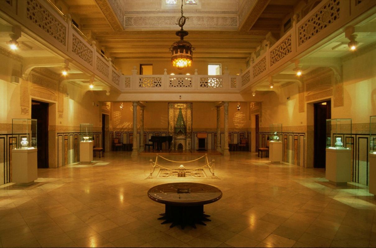
## Description The **Islamic Ceramics Museum (متحف الخزف الإسلامي)** is one of Cairo’s most refined and culturally rich museums, dedicated entirely to the art of **Islamic pottery and ceramics**. It offers visitors a rare opportunity to explore how clay, glaze, and fire were transformed into objects of beauty, science, and daily life across more than **a thousand years of Islamic civilization**. Housed inside the elegant **Palace of Princess Fatma Ismail**, a 19th-century aristocratic residence, the museum blends **architectural elegance with artistic mastery**. The palace itself is a masterpiece of late Ottoman and European-style architecture, featuring **ornate ceilings, stained glass, carved woodwork, and marble staircases**. Even before seeing the exhibits, the building alone is worth the visit. The museum’s collection includes **hundreds of ceramic pieces** from different Islamic periods and regions, including **Egypt, Persia (Iran), Andalusia (Spain), Turkey, Iraq, and Central Asia**. Displays range from **everyday household items**, such as bowls and jars, to **luxury palace ware, mosque tiles, and decorative panels**. Each object tells a story of trade, technological innovation, and artistic expression across the Islamic world. Key highlights include **lusterware ceramics**, known for their metallic shine, developed in medieval Iraq and Egypt; **Iznik tiles from Ottoman Turkey**, famous for their vivid blues and reds; and **Persian underglaze-painted ceramics**, celebrated for their delicate floral and calligraphic designs. Visitors can clearly trace how artistic styles traveled along trade routes and evolved across empires. What makes this museum especially unique is how it connects **science with art**. Islamic potters were pioneers in **chemistry and kiln technology**, developing methods for glazing, coloring, and firing that influenced European ceramics centuries later. The museum explains these processes in an accessible way, making it engaging even for visitors with no background in art or archaeology. A little-known fact is that the museum was originally opened in **1936**, making it one of the **earliest specialized ceramics museums in the Middle East**. Another lesser-known detail is that Princess Fatma Ismail, whose palace now hosts the museum, was the same royal figure who funded the establishment of **Cairo University**, making her a key patron of Egyptian education and culture. Quiet, elegant, and deeply educational, the Islamic Ceramics Museum offers a refined cultural experience that contrasts beautifully with the bustle of central Cairo. ## Location The **Islamic Ceramics Museum** is located in the **Zamalek district** of **Cairo**, Egypt — one of the city’s most upscale and culturally vibrant islands along the Nile. **Address:** 26 Gezira Street, Zamalek, Cairo, Egypt ### How to Get There: * **By metro:** Take Line 2 to **Opera Station**, then walk about 10 minutes toward Gezira/Zamalek. * **By taxi or ride-hailing apps:** Tell the driver “**Mithaf al-Khazaf al-Islami fi Zamalek**.” Most drivers recognize it as a cultural landmark. * **By walking:** If you are already in Zamalek, the museum is centrally located and easily walkable. * **By car:** Limited street parking is available; taxis are generally more convenient. Its location makes it ideal to combine with nearby attractions like the **Cairo Opera House**, **Modern Art Museum**, and **Gezira Art Center**. ## Tips * **Visit on a weekday:** The museum is usually quiet, but weekdays offer an especially peaceful atmosphere. * **Take your time with details:** Many of the finest motifs are small and intricate — slow observation is rewarded. * **Photography:** Allowed in most areas without flash; always confirm current rules at the entrance. * **Read the descriptions:** Many pieces include historical and scientific explanations that enhance appreciation. * **Combine with Zamalek cafés:** After your visit, relax at one of Zamalek’s many riverside cafés or cultural lounges. * **Allow 60–90 minutes:** This is enough time to explore the entire collection without rushing. * **Art lovers should not skip it:** If you appreciate design, geometry, or craftsmanship, this museum is a hidden gem. ## Conclusion The **Islamic Ceramics Museum in Cairo** is a quiet treasure that captures the refinement, innovation, and artistic brilliance of Islamic civilization through one of its most expressive mediums — ceramics. Set inside a royal palace and filled with works that span continents and centuries, the museum offers both **aesthetic pleasure and historical insight**. It is an ideal destination for travelers seeking a calmer, deeper cultural experience beyond Cairo’s monumental landmarks. ## FAQ **1. What is the Islamic Ceramics Museum famous for?** It is known for its extensive collection of **Islamic pottery and ceramic art** from across the Middle East, North Africa, and Central Asia. **2. Where is the museum located?** It is located in **Zamalek**, on Gezira Island in central Cairo. **3. How old is the museum?** It officially opened in **1936**, making it one of the oldest specialized ceramics museums in the region. **4. Who owned the palace originally?** The palace belonged to **Princess Fatma Ismail**, a member of Egypt’s royal family and a major patron of education. **5. How long does a typical visit take?** Most visitors spend between **one to one and a half hours** exploring the museum. **6. Is the museum suitable for children?** Yes, especially for older children interested in history, art, and patterns, though it is a quiet, observation-focused museum. **7. Can I combine it with other museums in the same day?** Yes — it pairs well with visits to the **Cairo Opera House**, **Museum of Modern Egyptian Art**, and **Gezira Art Center**. ## Links * [Egyptian Ministry of Tourism and Antiquities – Museums](https://egymonuments.gov.eg)
GemVoyage Team • World
Hurghada
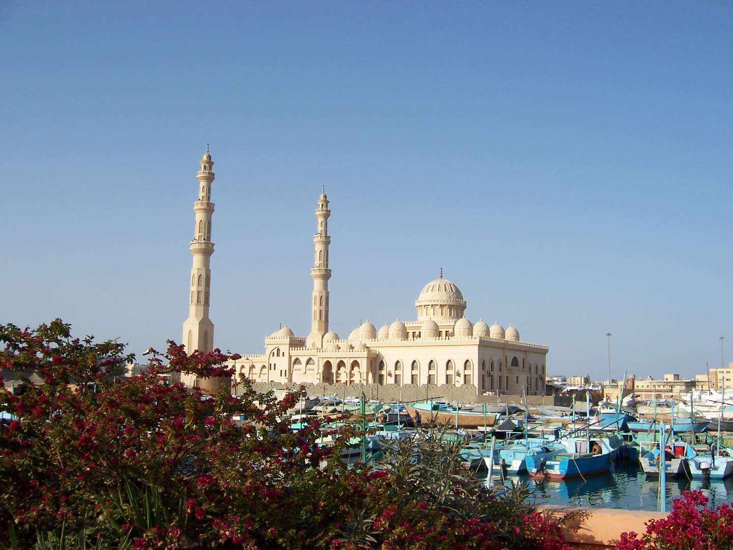
## Description Al Mina Mosque, also known as El Mina Masjid or the Grand Mosque of Hurghada, is one of the most striking religious landmarks on Egypt’s Red Sea coast. Completed in 2012, this architectural gem blends traditional Islamic design with modern elegance, making it a must-see for visitors seeking cultural depth beyond the beaches and resorts. With its gleaming white marble façade, towering minarets, and intricately carved domes, the mosque stands as a symbol of spiritual devotion and artistic craftsmanship. The mosque features two minarets that rise 40 meters into the sky and a central dome that reaches 25 meters in height. Inside, visitors are greeted by a serene prayer hall adorned with ornate chandeliers, engraved walls, and geometric patterns that reflect centuries of Islamic art. The mosque can accommodate up to 10,000 worshippers, making it the largest in the Red Sea Governorate. A little-known fact: Al Mina Mosque was built on an 8,000-square-meter site adjacent to Hurghada’s harbor, and its name—“Al Mina”—translates to “The Port,” referencing its proximity to the sea. The mosque also houses an Islamic cultural center that offers lectures and educational materials in multiple languages, aimed at fostering interfaith understanding and dialogue. ## Location Al Mina Mosque is located in **Egypt**, in the **Red Sea Governorate**, within the **city of Hurghada**. It sits directly on the waterfront near the Hurghada Marina and the city’s main harbor, making it easily accessible from both the old town (El Dahar) and the newer resort areas. ### How to Get There - **By Taxi**: Taxis are readily available throughout Hurghada and can take you directly to the mosque entrance. - **By Foot**: If you’re staying near the Marina or Sheraton Road, the mosque is within walking distance. - **By Tour**: Many city tours include a stop at Al Mina Mosque, often paired with visits to local markets and cultural sites. - **By Public Transport**: Minibuses and shared taxis frequently pass through the area, though they may require some navigation. Its central location makes it an ideal stop during a day of sightseeing or evening stroll along the harbor. ## Tips - **Visit Outside Prayer Times**: Non-Muslim visitors are welcome to explore the mosque during non-prayer hours. Avoid visiting during Friday prayers or religious holidays. - **Dress Modestly**: Women should cover their hair, shoulders, and knees. Men should avoid shorts. Scarves and robes may be provided at the entrance. - **Photography**: While exterior photography is encouraged, ask permission before taking photos inside, especially during prayer times. - **Respect the Space**: This is an active place of worship. Maintain a quiet and respectful demeanor. - **Combine with Nearby Attractions**: After visiting the mosque, explore the Hurghada Marina, local bazaars, or enjoy a meal at one of the waterfront restaurants. - **Check for Cultural Events**: The mosque’s Islamic center occasionally hosts lectures and exhibitions open to the public. ## Conclusion Al Mina Mosque is a serene and visually stunning destination that offers a glimpse into Egypt’s Islamic heritage. With its majestic architecture, peaceful ambiance, and central location, it’s a rewarding stop for anyone exploring Hurghada beyond the beach. ## FAQ **1. What are the opening hours of Al Mina Mosque?** The mosque is open daily from 9:00 AM to 5:00 PM, except during prayer times. **2. Is there an entrance fee?** No, entry is free. Donations to the mosque or its cultural center are welcome but not required. **3. Can non-Muslims visit the mosque?** Yes, non-Muslims are welcome during non-prayer hours and are encouraged to learn about the mosque’s history and architecture. **4. Is the mosque wheelchair accessible?** Yes, the mosque has ramps and accessible entrances for visitors with mobility needs. **5. Are guided tours available?** Some local guides offer cultural tours that include the mosque. The Islamic center also provides multilingual materials and lectures. **6. Is it safe to visit the mosque with children?** Yes, families are welcome. Children should be supervised and respectful of the prayer areas. ## Links - [Al Mina Mosque Visitor Guide – Hurghada Day](https://hurghadaday.com/things-to-do/al-mina-mosque/)
GemVoyage Team • World
Gmunden
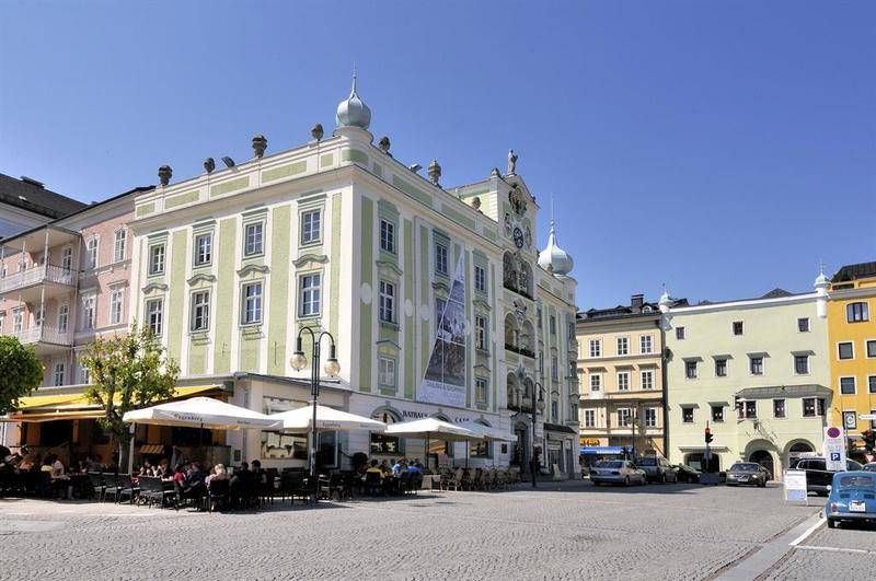
## Description The **Rathaus Gmunden** — the **Town Hall of Gmunden** — is one of Austria’s most charming and picturesque civic buildings, perfectly reflecting the town’s **historic elegance and lakeside serenity**. Standing proudly on the shore of **Traunsee Lake**, surrounded by the scenic peaks of the **Salzkammergut Mountains**, this 16th-century building combines Renaissance architecture, local craftsmanship, and cultural pride in a way few town halls do. Built between **1574 and 1577**, the Rathaus originally served as a **merchant and administrative center** during a period when Gmunden was thriving as a salt-trading hub. Its architecture features a **Renaissance façade** with beautifully arched arcades, intricate window frames, and an elegant clock tower topped with a small bell turret. The building’s exterior is painted in soft pastel hues that harmonize with the lakeside scenery, giving it a warm and inviting appearance. However, what truly makes Rathaus Gmunden stand out — and one of Austria’s most photographed town halls — is its **ceramic carillon** (a set of bells made from Gmunden pottery). Installed in **1961**, this unique feature consists of **24 hand-painted ceramic bells**, crafted by local artisans from the renowned **Gmundner Keramik** workshop, which has been producing distinctive green-flamed pottery since the 17th century. Several times a day, the bells chime melodiously across the old town, filling the air with a sound that has become a symbol of Gmunden’s artistic heritage. Few visitors realize that it is **one of the only ceramic carillons in the world** still in operation — a beautiful fusion of art, music, and tradition. Inside, the Rathaus still functions as the **seat of the local government**, but parts of it are open to visitors, showcasing historical rooms, exhibitions, and cultural displays. The nearby **Rathausplatz (Town Hall Square)** hosts markets, festivals, and outdoor concerts throughout the year, offering a lively glimpse of local life. Whether you visit for its craftsmanship, its lakeside views, or the charm of its daily chimes, Rathaus Gmunden is a small-town treasure that embodies the **soul of the Austrian Alps**. ## Location The **Rathaus Gmunden** is located in the **heart of Gmunden**, a town in **Upper Austria (Oberösterreich)**, on the **northern shore of Lake Traunsee**. **Address:** Rathausplatz 1, 4810 Gmunden, Austria To get there: * **By train:** From **Linz** or **Salzburg**, take an **ÖBB regional train** to **Gmunden Station**, then walk about **10–15 minutes** to the old town. * **By tram:** From the station, you can also take the **Traunseetram**, which stops near Rathausplatz. * **By car:** Easily accessible via the **A1 motorway**, exit **Regau** or **Laakirchen**, with several nearby parking options. * **By boat:** Ferries on **Traunsee Lake** stop at **Gmunden Seebahnhof**, just steps away from the Town Hall. * **By foot or bike:** The promenade around the lake connects the Rathaus to the main attractions of Gmunden, including **Schloss Ort** and the **Esplanade**. ## Tips * **Don’t miss the carillon performance:** The ceramic bells ring several times daily — typically at **11:00 AM**, **3:00 PM**, and **5:00 PM** (check local schedules). * **Visit the Gmundner Keramik Manufaktur:** Just outside town, you can see how the world-famous green-flamed pottery is made — a perfect complement to the Rathaus visit. * **Take photos from the lake promenade:** The Town Hall reflected in the water, with mountains in the background, is one of Austria’s most postcard-worthy views. * **Enjoy the market:** On Fridays, Rathausplatz hosts a **local farmers’ market** selling fresh regional produce, cheese, and crafts. * **Visit nearby Schloss Ort:** A short walk away, this fairytale castle on the lake is another Gmunden highlight. * **Stop for coffee by the lake:** There are several cozy cafés around Rathausplatz with views of the water and the mountains. * **Combine with a boat tour:** Scenic cruises on Traunsee often pass by the Rathaus, offering a new perspective from the lake. ## Conclusion The **Rathaus Gmunden** is far more than a historic building — it’s the **heart of a town steeped in art, tradition, and Alpine beauty**. From its Renaissance architecture to the enchanting ceramic bells that sing across Traunsee, it tells the story of a community that has blended craftsmanship and culture for centuries. Whether you’re exploring the Salzkammergut for its lakes, castles, or peaceful charm, a stop at the Rathaus Gmunden is an experience that captures the very essence of Austrian heritage. ## FAQ **1. When was the Rathaus Gmunden built?** It was constructed between **1574 and 1577** during the height of Gmunden’s salt-trading prosperity. **2. What makes the Rathaus special?** Its **ceramic carillon**, made from locally produced Gmundner pottery, is **one of the few of its kind in the world**. **3. How often does the carillon play?** The bells ring several times daily, typically at **11:00 AM, 3:00 PM, and 5:00 PM**, though times may vary seasonally. **4. Can visitors enter the Rathaus?** Yes, parts of the building are open to visitors, especially during cultural events or exhibitions. **5. Where is Gmunden located?** Gmunden lies on **Lake Traunsee** in **Upper Austria (Oberösterreich)**, roughly halfway between **Linz** and **Salzburg**. **6. Is it easy to reach from Vienna or Salzburg?** Yes — from Vienna or Salzburg, take a train to **Attnang-Puchheim**, then connect to Gmunden via a regional line (total travel time: around **2 hours**). **7. What nearby attractions should I see?** Don’t miss **Schloss Ort**, **Traunsee Lake cruises**, and the **Gmundner Keramik Factory** for a complete cultural experience. ## Links * [Gmunden Tourism Official Website](https://www.gmunden.at)
GemVoyage Team • World
Athens
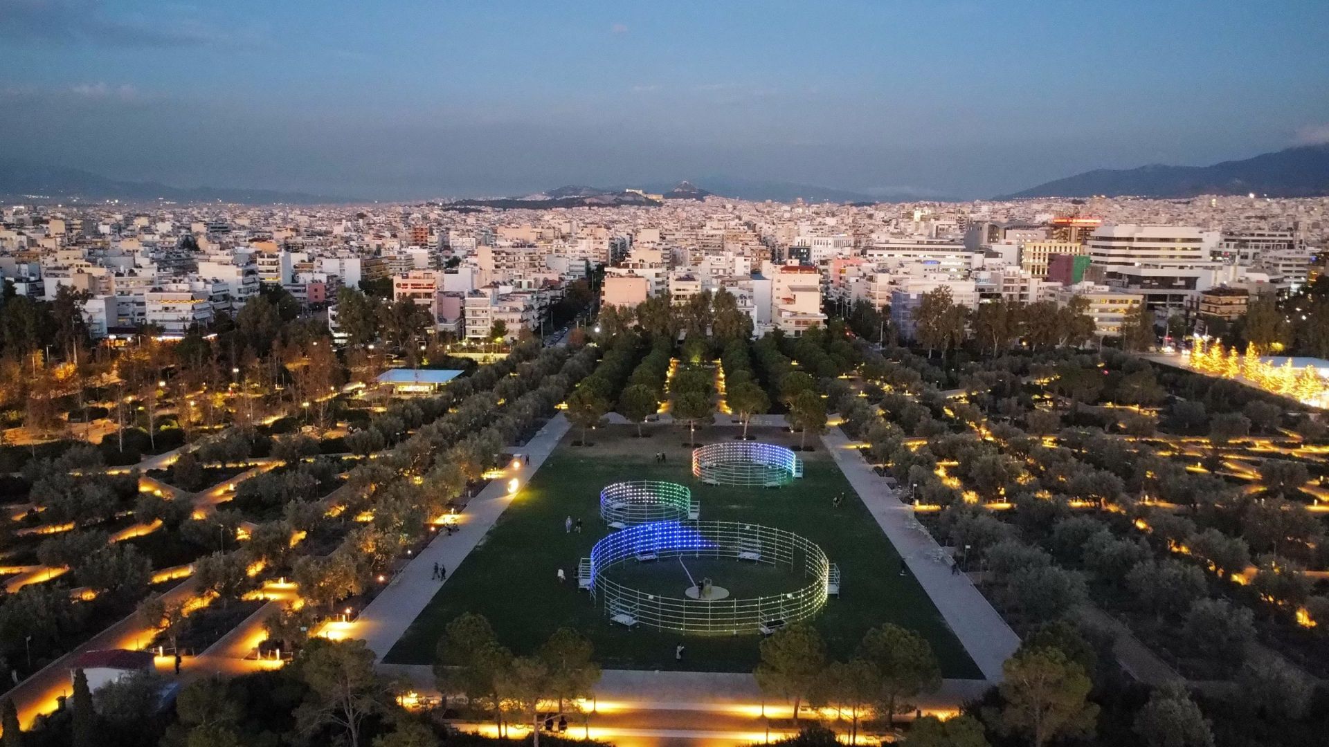
## Description Stavros Niarchos Park is one of the most impressive modern public spaces in Athens and a compelling reason to look beyond the city’s ancient monuments. It is part of the larger Stavros Niarchos Foundation Cultural Center, and it has become known for its open lawns, long walking paths, planted slopes, water features, and elevated views. The park feels spacious and carefully composed, which is a welcome contrast to the denser parts of central Athens. The appeal of the park lies in its blend of architecture, landscape design, and civic function. It is not simply decorative. It was created to give residents and visitors a place for recreation, events, and relaxed outdoor time in a city that can otherwise feel intensely urban. A little-known detail is that the park includes an artificial hill that helps shape the site’s views and gives visitors a raised perspective over Athens and toward the sea. That design choice makes the park feel dynamic rather than flat. Another reason the park stands out is that it reflects a modern chapter in Athens’ story. Many travelers come to the city for antiquity, but this space shows that contemporary Athens also has ambitious public architecture and thoughtful urban design. The result is a place that works for many different types of visitors. Families come to stroll, runners use the paths, couples come for sunset, and architecture enthusiasts come to examine the way the landscape and buildings interact. The park is especially pleasant when the weather is good. Athens has strong sunlight for much of the year, and the open layout makes the site feel bright, clean, and alive. Because it connects cultural programming with everyday outdoor use, it is not just a park you pass through. It is a place to spend real time in, and the experience often changes depending on the hour of the day or the event calendar. ## Location Stavros Niarchos Park is in Athens, Greece, in the Kallithea area near the coastline and south of the city center. It is part of the Stavros Niarchos Foundation Cultural Center, so visitors often experience the park together with the surrounding cultural buildings and public spaces. The easiest way to get there is by public transport, taxi, or rideshare from central Athens. Depending on your starting point, tram or bus connections can also work well. If you are staying in the center, the park is simple enough to include in a half-day plan, especially if you want a break from the dense historic core of the city. Because the site is well connected and clearly marked, it is one of the more straightforward modern attractions to reach. If you have time, combine the visit with a walk through the surrounding area or a stop at the waterfront. That helps show how the park fits into Athens beyond the Acropolis-heavy itinerary most first-time travelers follow. ## Tips Visit in the late afternoon if you want better light and a more relaxed atmosphere. Sunset is especially attractive because the views across the park and toward the city become softer. Bring comfortable shoes. The site is large enough that you will want to walk it properly, and the different levels make a full circuit more interesting than a quick pass-through. Check the event calendar before you go. Public performances, concerts, or cultural activities can add a lot to the experience if your timing is right. If you are with children or want a quieter reset during a busy sightseeing day, this is one of the best modern spaces in Athens for a pause. ## Conclusion Stavros Niarchos Park shows a modern, open, and design-forward side of Athens. It is a highly enjoyable place to walk, relax, and see how contemporary public space can complement the city’s historical identity. ## FAQ **Is Stavros Niarchos Park just a park?** No. It is part of a larger cultural center with architecture, public space, and programming. **Is it worth visiting if I only have time for ancient sites?** Yes, because it gives a different and refreshing view of Athens. **How long should I spend there?** At least one to two hours, more if you want to explore thoroughly or attend an event. **Is it family-friendly?** Very much so. The open layout and walkable design make it easy to enjoy with children. **What is the best time to go?** Late afternoon or sunset is especially good for atmosphere and views. ## Links - [Official website](https://www.snfcc.org/en/) - [Wikipedia](https://en.wikipedia.org/wiki/Stavros_Niarchos_Foundation_Cultural_Center)
GemVoyage Team • World

Comments